AToMS (Airborne Taxonomic Mapping System)
Airborne Sensors
AToMS (Airborne Taxonomic Mapping System)
Overview
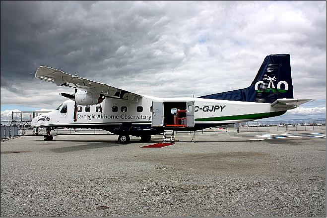
AToMS is an airborne high-resolution imaging instrumentation of CAO (Carnegie Airborne Observatory), a facility of the Carnegie Institution for Science. The CAO instruments are operated onboard a Dornier 228 aircraft with customized avionics, instrument facilities and sensor mounts. The CAO instrumentation is maintained in the Carnegie Institution's Department of Global Ecology on the campus of Stanford University, Stanford, CA, USA. 1) 2) 3) 4) 5)
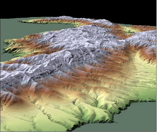
The original Carnegie Airborne Observatory (CAO), which launched in late 2006, used an aircraft-borne spectrometer and laser detection and ranging (LiDAR) to provide three-dimensional mapping of ecosystems at a level appropriate for monitoring deforestation and forest degradation. The original system provided spectral information in the visible and near infrared wavelength regions and vegetation structural information at a spatial resolution of about 1 m, on a scale of approximately 10,000 hectares a day, and at a cost of less than 10 cents per ha (hectare). As a result, it has been used to map millions of ha in countries around the world, leading to scientific discoveries ranging from spatially explicit quantification of forest carbon in remote areas of the Amazon to the impacts of elephants and lions in Africa’s savannas.
• CAO Alpha operated in Central America and Amazonia until early 2011 before being decommissioned. It operated from 2007-2011, and consisted of an integrated VNIR (Visible Near Infrared) imaging spectrometer and waveform LiDAR (Light Detection and Ranging) system.
• The CAO Beta system (decommissioned) was comprised of the CAO LiDAR system integrated with the AVIRIS (Airborne Visible and Infrared Imaging Spectrometer) of JPL. This mode provided spectral information spanning the 380-2510 nm wavelength region, along with high-resolution LiDAR data. The CAO Beta system was the research testbed for the CAO AToMS airborne system.
• The new CAO-II AToMS was launched on June 2 2011 and is operating in the Western Amazon Basin in 2011.
The CAO works by combining laser and spectrometer remote sensing technologies, along with high-tech inertial motion sensors to track the aircraft’s position and orientation to exacting tolerances. The laser technology, called LiDAR, measures the 3D structure of the vegetation and terrain. The spectrometers measure the way that sunlight reflects off vegetation, soils, and other ecosystem components, which yields chemical and physiological information.
The newly developed AToMS instrumentation package is regarded a next generation sensor suite (first flight in the summer of 2011). The system will provide higher resolution laser and spectroscopic information extending from the visible through the shortwave-infrared region of the spectrum. It will be operated from its new Dornier 228 aircraft. The dramatic increase in measurement capability provided by AToMS will provide a major leap forward for CAO science in support of Earth science and exploration, biological conservation, and resource policy development.
Sensor Complement
The AToMS instrument suite was designed by Greg Asner of the Carnegie Institution and manufasctured by many sub-contractors. NASA/JPL (Jet Propulsion Laboratory), Pasadena, CA is the prime contractor for the VSWIR imaging spectrometer.
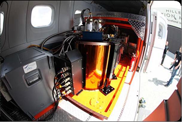
The AToMS instrument package is comprised of three custom-built instruments: 6)
VSWIR (Visible and Shortwave Infrared) Imaging Spectrometer
Measuring reflected solar radiance from 380-2500 nm in 5 nm increments (> 400 bands); the spatial resolution is 0.5-2.0 m, depending on the flight altitude.
Wavelength range (VSWIR) | 380 - 2510 nm |
Spectral resolution | 5 nm |
Spatial resolution | 0.5-2.0 m, depending upon aircraft altitude |
Data quantization | 14 bit |
IFOV (Instantaneous Field of View) | 1 mrad |
FOV | 34º |
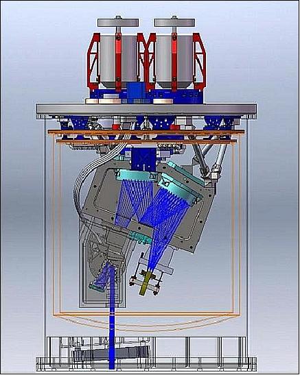
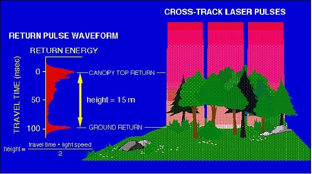
Multi-Pulse Waveform LiDAR (Light Detection and Ranging)
A high-resolution waveform LiDAR system providing contiguous ground coverage and full three-dimensional imaging. The instrument measures up to 400,000 pulses/s with dual laser beams; 0.5-1.0 m spatial resolution.
Wavelength | 1064 nm |
Laser pulse repetition frequency | Up to 400 kHz |
Spatial resolution (laser spot spacing) | 0.25-1.0 m, depending upon aircraft altitude |
Sampling | Dual laser |
Digitization | Full waveform and discrete-return digitization |
FOV (Field of View) | 40º |
VNIR (Visible Near Infrared) Zoom Imaging Spectrometer
A high-fidelity imaging system providing contiguous spectral signatures of targets in VNIR. The instrument measures reflected solar radiance from 367-1060 nm in 5 nm increments; 0.5-1.0 m spatial resolution.
Wavelength range (VNIR) | 365 - 1060 nm |
Spectral resolution | 3 - 10 nm, configurable |
Spatial resolution | 0.25-1.0 m, depending upon aircraft altitude |
Data quantization | 14 bit |
IFOV (Instantaneous Field of View) | 0.5 mrad |
FOV | 40º |
Spectranomics Database
To interpret the new data stream coming from AToMS, the team has developed the world's first Spectranomics Database to link the phylogenetic organization of tropical plants to their spectroscopic and chemical signatures. The Spectranomics Database is a critical step required to advance regional and global biodiversity mapping efforts in the coming decades.
Past CAO Observations
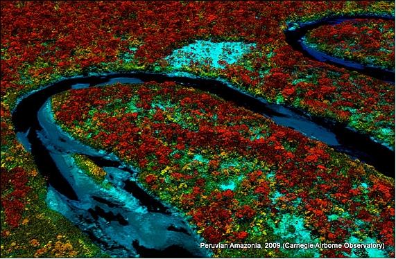
The United Nations REDD (Reduce Emissions from Deforestation and Degradation) program requires high-resolution mapping of tropical forest carbon to support climate change mitigation. With a new integration of satellite imaging, airborne Light Detection and Ranging, and field plots, the CAO project mapped above-ground carbon stocks and emissions at 0.1 ha resolution over 4.3 million ha of the Peruvian Amazon, revealing variation at multiple scales due to geologic substrate, forest type, and land use.
References
1) Greg Asner, “Carnegie Airborne Observatory AToMS - Airborne Taxonomic Mapping System,” June 2, 2011, URL: http://dge.stanford.edu/news/news/CAO-Launch.pdf
2) http://cao.stanford.edu/?page=cao_systems
3) Carnegie Institution for Science, "Carnegie Airborne Observatory Mission," URL: [web source no longer available]
4) ftp://dge.stanford.edu/pub/asner/web/IntroAToMS.pdf
5) Jeff Tollefson, “A new eye on biodiversity - Airborne observatory will use chemical clues to map and assess tropical ecosystems,” Nature, Vol. 474, pp. 13-14, June 1, 2011, URL: http://www.nature.com/news/2011/110601/full/474013a.html
6) Information provided by Gregory P. Asner of Carnegie Institution's Department of Global Ecology, Stanford University
7) http://cao.stanford.edu/?page=images#
The information compiled and edited in this article was provided by Herbert J. Kramer from his documentation of: "Observation of the Earth and Its Environment: Survey of Missions and Sensors" (Springer Verlag) as well as many other sources after the publication of the 4th edition in 2002. - Comments and corrections to this article are always welcome for further updates (eoportal@symbios.space).