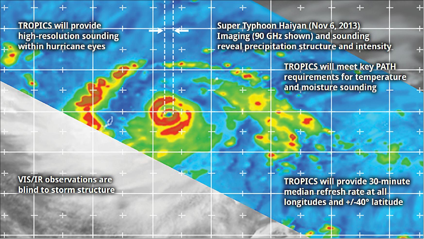
TROPICS (Time-Resolved Observations of Precipitation structure and storm Intensity with a Constellation of Smallsats)
EO
Atmosphere
Liquid water and precipitation rate
Atmospheric Temperature Fields
With all four satellites launched in May 2023, TROPICS (Time-Resolved Observations of Precipitation structure and storm Intensity with a Constellation of Smallsats) is a constellation of four microwave imaging 3U CubeSats (excluding the pathfinder) operated by the National Aeronautical and Space Administration (NASA). It aims to measure temperature, humidity, and precipitation so that we may better understand the evolution and structure of storm systems.
Quick facts
Overview
| Mission type | EO |
| Agency | NASA |
| Mission status | Operational (nominal) |
| Launch date | 30 Jun 2021 |
| Measurement domain | Atmosphere |
| Measurement category | Liquid water and precipitation rate, Atmospheric Temperature Fields, Atmospheric Humidity Fields |
| Measurement detailed | Precipitation intensity at the surface (liquid or solid), Atmospheric specific humidity (column/profile), Atmospheric temperature (column/profile) |
| Instruments | TROPICS |
| Instrument type | Imaging multi-spectral radiometers (passive microwave) |
| CEOS EO Handbook | See TROPICS (Time-Resolved Observations of Precipitation structure and storm Intensity with a Constellation of Smallsats) summary |
Summary
Mission Capabilities
Each TROPICS CubeSat is equipped with a single instrument, a microwave spectrometer. By passively measuring microwaves of different frequencies they will measure temperature, humidity, and precipitation. These measurements will be taken with a higher frequency than previous satellites so that we can acquire a more accurate image of how storm systems change over time.
Performance Specifications
The microwave spectrometer onboard each TROPICS CubeSat observes over 12 spectral bands: seven to measure temperature, three for humidity, one for precipitation, and one for cloud ice. Whilst spinning at 30 rpm, the spectrometer will observe over a swath of 2000 km with a spatial resolution of 25 km.
TROPICS CubeSats will operate in pairs with each pair having its own orbital plane and separation of 180°. Each CubeSat will undertake a non-sun-synchronous orbit with an altitude of 550 km and an inclination of 30°.
Space and Hardware Components
On June 12, 2022, the first two of the originally planned six TROPICS CubeSats were launched from the Cape Canaveral Space Force Station but failed to reach orbit because the second stage engine shut down prematurely. NASA believes that the objectives of TROPICS will still be completed with the remaining four satellites.
TROPICS (Time-Resolved Observations of Precipitation structure and storm Intensity with a Constellation of Smallsats)
Space Vehicles Launch Mission Status Sensor Complement Ground Segment References
In March 2016, NASA selected t two proposals for new Earth science investigations that will put new instruments in low-Earth orbit to track harmful particulate air pollutants and study the development and lifecycles over much of TCs (Tropical Cyclones). The measurements will provide nearly all-weather observations of 3D temperature and humidity, as well as cloud ice, precipitation horizontal structure and instantaneous surface rain rates. These measurements and the increased temporal resolution provided by the CubeSat constellation, are needed to better understand the TC lifecycles and the environmental factors that affect the intensification of TCs. 1) 2) 3)
Observations of small atmospheric aerosols from the MAIA (Multi-Angle Imager for Aerosols) will be combined with health information to determine the toxicity of different particulate matter types in airborne pollutants over the world's major cities.
The TROPICS investigation will develop and launch a constellation of CubeSats to study the development of tropical cyclones through rapid-revisit sampling. William Blackwell of MIT/LL (Massachusetts Institute of Technology'/Lincoln Laboratory) in Lexington is the PI (Principal Investigator) of the TROPICS mission.
The science objectives are: 4) 5)
• Relate the precipitation structure evolution, including the diurnal cycle, to the evolution of the upper-level warm core and associated intensity changes
• Relate the occurrence of intense precipitation cores (convective bursts) to storm intensity evolution
• Relate the retrieved environmental moisture measurements to coincident measures of storm structure (including size) and intensity
• Assimilate microwave radiances and/or retrievals in mesoscale and global numerical weather prediction models to assess impacts on storm track and intensity.
TROPICS mission significance to NASA and NOAA:
• First high-revisit microwave nearly global observations of precipitation, temperature, and humidity
• Fulfills most of the PATH (Precipitation All-weather Temperature and Humidity Soundings) Decadal Survey mission objectives using a low-cost, easy-to-launch CubeSat constellation
• Complements GPM, CYGNSS, and GOES-R missions with high refresh, near-all-weather measurements of precipitation and thermodynamic structure
• Increases understanding of critical processes driving significant and rapid changes in storm structure/intensity.
The TROPICS science program is directly relevant to three of the six NASA Earth Science Focus Areas: Weather, Water and Energy Cycle, and Climate Variability and Change. TROPICS addresses goals and objectives from the 2014 NASA Strategic Plan including advancing the understanding of Earth and developing technologies to improve the quality of life on our home planet (strategic goal 2) and advancing knowledge of Earth as a system to meet the challenges of environmental change and to improve life on our planet (objective 2.2).
The fundamental physical parameters required to address the TROPICS science objectives are 3D atmospheric temperature and humidity, storm intensity, and horizontal precipitation structure. These parameters have a long heritage of being derived from spaceborne PMW imagery and sounding channels (e.g., AMSU, ATMS, SSMIS). Practical considerations of antenna and instrument size and mass for a CubeSat system guide the selection of PMW (Passive MicroWave) channels for TROPICS.
Temperature and moisture profiles are retrievable from seven channels near 118 GHz and three near 183 GHz, respectively. Precipitation structure is obtained from a combination of 90 GHz, 206 GHz, and the temperature and moisture channels, with horizontal resolution matching that of the moisture data due to the high sensitivity to precipitation hydrometeors at 183 GHz. The 206-GHz channel will be sensitive to smaller ice particles than the 90-GHz channel and will generally produce a stronger signal. These observables link back to science requirements and to the primary sensor requirements (horizontal and vertical resolution and sensitivity).
The TROPICS constellation will consist of six 3U CubeSats, each about 30 cm long with a mass of 6 kg, that use scanning microwave radiometers to measure temperature, humidity, precipitation and cloud properties. The CubeSats will be launched into three separate orbital planes to enable the overall constellation to monitor changes in tropical cyclones as frequently as every 21 minutes.
The TROPICS team has previous experience developing CubeSats and analyzing satellite measurements of storms, and includes partnerships with NASA's Wallops Flight Facility in Wallops Island, Virginia, Goddard, several universities and NOAA (National Oceanic and Atmospheric Administration).

MIT/LL (Lincoln Laboratory), Lexington, MA | PI institution, CubeSat development, calibration and testing, Level 1 data product lead, Level 2 algorithm developer, Science Operations Center |
University of Wisconsin – Madison, WI | Data Processing Center, Level 2 data product lead and algorithm developer, science relating warm-core evolution to storm structure and intensity |
NOAA National Weather Service, National Hurricane Center | Study precipitation structure evolution and microwave parameters in statistical storm intensity models |
MIT/SSL (Space Systems Laboratory) | Data validation |
University of Miami, CIMAS (Cooperative Institute of Marine and Atmospheric Studies), Miami, FL | Study relationship between moisture and precipitation to the storm's structure and intensity, diurnal cycle of hurricane structure |
NASA Wallops | FM CubeSat assembly and test, ground stations, Mission Planning Center |
USU (Utah State University) SDL (Space Dynamics Laboratory) | Mission Operations Center, Ground Station Network |
University of Massachusetts, Amherst | Receiver front end |
NOAA AOML (Atlantic Oceanographic Meteorological Laboratory), Miami, FL | Regional assimilation leadership; intensity and track forecasting; operations calibration and validation |
Cornell University, Ithaca, NY | Optimize constellation architecture; orbital analysis to maintain constellation revisit rates |
Tufts University, Medford, MA | Geolocation and calibration |
Space Vehicles
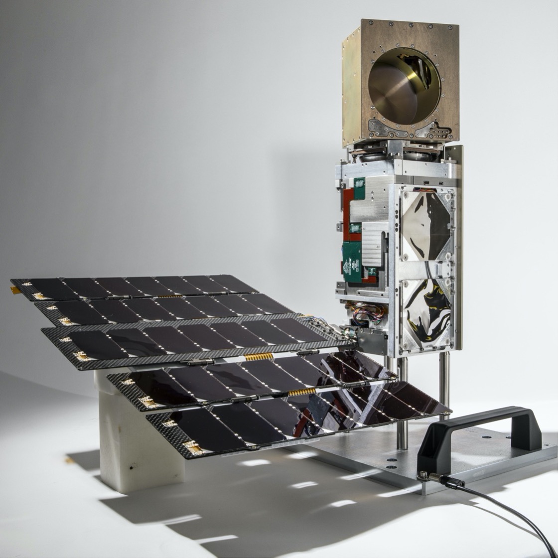
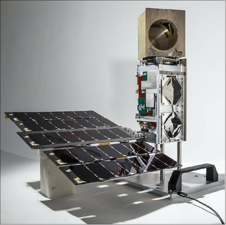
Each TROPICS CubeSat is a dual-spinning 3U CubeSat (6 kg) equipped with a 12-channel passive microwave spectrometer providing imagery near 90 and 206 GHz, temperature sounding near 118 GHz, and moisture sounding near 183 GHz. Each commercially-procured CubeSat comprises a 2U spacecraft bus with ADCS, avionics, power, and communications, and a 1U spinning radiometer payload with highly integrated, compact microwave receiver electronics.
The spectrometer payload consists of a rotating passive RF antenna measuring spectral radiance as it rotates about the CubeSat velocity vector. The payload is based upon a similar design previously flown by MIT/LL on the MicroMAS-2 (Micro-sized Microwave Atmospheric Satellite-2)mission. However, a significant amount of redesign has been required to meet TROPICS performance and mission reliability requirements. The redesign includes:
1) Antenna modification to optimize ground profile while minimizing side lobes
2) Noise reduction in the analog front end
3) Higher-dynamic-range in the analog-to-digital converter
4) Modifications to spectrometer channel center frequencies and bandwidths
5) Higher-reliability control electronics
6) Higher-reliability and lower-power scanner assembly
A notional SV including the bus and payload is shown in Figure 5. The MicroMAS-2 bus does not have sufficient pointing accuracy or power generation capability to meet the TROPICS mission requirements. The TROPICS bus will match much of the functionality of the MicroMAS-2 bus, but will take advantage of recent advances in CubeSat bus technology and reliability.
BCT will build seven identical XACT-based 3U-class CubeSats for the TROPICS (Time-Resolved Observations of Precipitation structure and storm Intensity with a Constellation of Smallsats) mission. The satellites will be divided into three low-Earth orbital planes and will consist of a single high-performance radiometer payload hosted on each spacecraft bus. Each payload includes a BCT-designed motor as well as electronics to control the MIT/LL (Massachusetts Institute of Technology/Lincoln Laboratory) payload spin mechanism. 6)
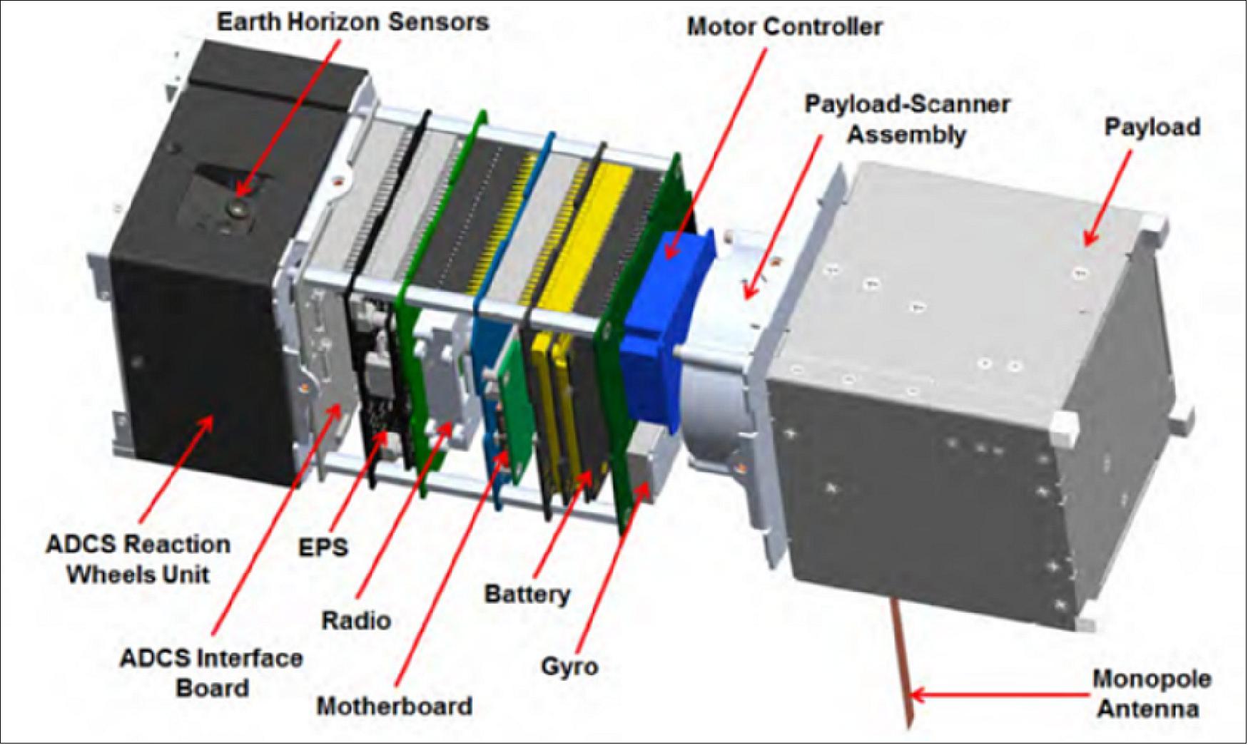
Figure 5: MicroMAS-2 Space vehicle (without solar panels), image credit: TROPICS collaboration
Launch
Launch of TROPICS Pathfinder mission: The TROPICS Pathfinder mission of NASA was launched on the SpaceX Transporter-2 rideshare mission on June 30 2021 at 19:31 UTC from Cape Canaveral SLC-40. The TROPICS Pathfinder CubeSat was one of 88 small satellites on this mission of SpaceX. 11)
Orbit: Sun-synchronous orbit of 550 km altitude.
Launch of TROPICS Constellation: The first two TROPICS 3U CubeSats were lost in a launch failure by Astra Space on the Rocket 3.3 vehicle on June 12, 2022. The satellites were launched from Space Launch Complex 46 at Cape Canaveral Space Force Station in Florida at 18:42 UTC. The mission failed to reach orbit due to the premature shutdown of the second stage engine. 17)
The four remaining TROPICS CubeSats were launched by Rocket Lab on two Electron Rockets.
The first of the two Rocket Lab launches successfully took place on 8 May 2023 at 01:00 UTC, and the second and final of these launches successfully lifted off on 26 May 2023, at 03:46 UTC.
Orbit: Near circular orbit of 600 km altitude (550±50 km tolerance), 30° inclination (±3° tolerance).
Mission Status
• 26 May 2023: The second and final of TROPICS launches successfully lifted off on 26 May 2023 at 03:46 UTC from Rocket Lab’s Launch Complex 1 Pad B in Māhia, New Zealand.
• 8 May 2023: Rocket Lab successfully launched the first two TROPICS cubesats from a pad on Mahia Peninsula, New Zealand at 01:00 UTC.
• November 23, 2022: NASA has selected Rocket Lab to launch the TROPICS satellites as a part of the agency's Venture-class Acquisition of Dedicated and Rideshare (VADR) launch service. Rocket Lab will launch the satellites into their operational orbits over a 60-day period, on two Electron Rockets launched no earlier than May 1, 2023. Following the successful launches, NASA aims to provide observations with TROPICS during the 2023 Atlantic hurricane season, which starts June 1. 18)
• September 28, 2022: Following the failed launch of the first two TROPICS CubeSats, Astra will now launch “comparable scientific payloads” for NASA instead of the four remaining satellites in the constellation, after a contract modification agreement between the two agencies. NASA states that the mission can still achieve its science objectives with only four satellites. After the failed launch, Astra retired the Rocket 3.3 launch vehicle to focus on the larger Rocket 4 for the launch of the remaining TROPICS satellites, however the launcher would have been a poor fit for the CubeSats hence the contract modification was imposed. 19)
NASA announced that the remaining satellites would be launched by a different launch provider prior to the 2023 hurricane season. 20)
• September 13, 2021: On August 8, NASA's TROPICS Pathfinder satellite captured global first light images as well as a look inside the structure of Hurricane Ida before and after it made landfall. 12)
- The satellite launched on June 30, 2021 as the pathfinder – or test – satellite for NASA's Time-Resolved Observations of Precipitation structure and storm Intensity with a Constellation of Smallsats (TROPICS) mission. The Pathfinder satellite provides an opportunity to test the technology, communication systems, and data processing before the six satellites comprising the TROPICS constellation launch in 2022. "[Pathfinder] is like a dress rehearsal of the mission," said Bill Blackwell, the principal investigator for the TROPICS mission and a researcher at the Massachusetts Institute of Technology Lincoln Laboratory in Lexington, Massachusetts.
- The future TROPICS constellation will orbit Earth in three planes, collecting temperature, water vapor, precipitation, and cloud ice measurements on a frequent, near-global scale to study storms and other meteorological events. The idea is that multiple satellites in spread out orbits will collect more frequent measurements around the globe, allowing scientists to study storms as they develop and then use the newly-acquired knowledge to improve forecasting capabilities. The TROPICS research team includes researchers from NASA, the National Oceanic and Atmospheric Administration (NOAA), and several universities and commercial partners.
- "Early in the mission, the Pathfinder satellite has already demonstrated the usefulness of this data – especially the images of Hurricane Ida. We're able to see a lot of features that we want to study with the TROPICS constellation," said Blackwell.
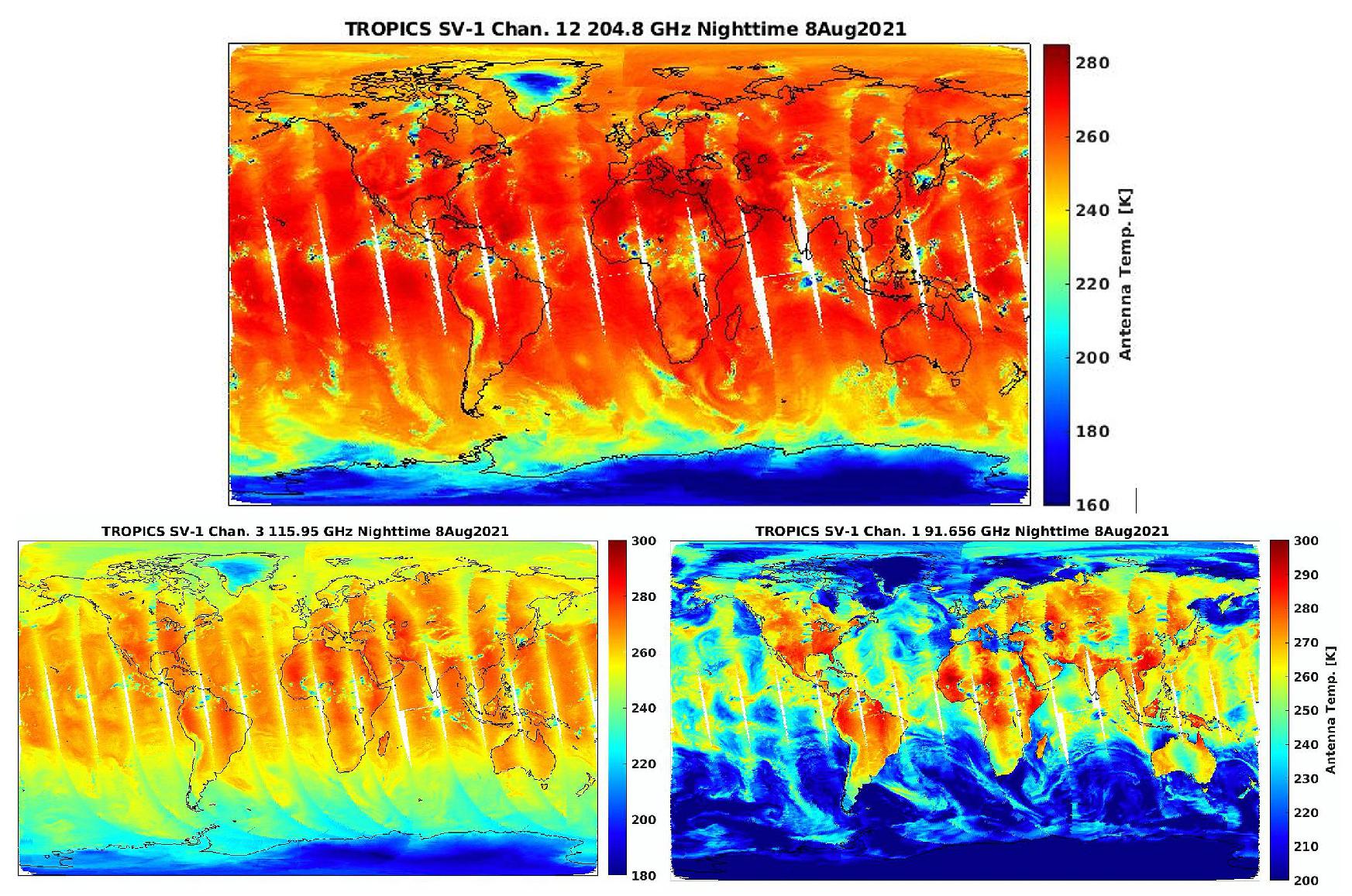
- The global first light images show microwave data collected at several frequencies, each giving scientists a different piece of the larger puzzle of thermodynamics in Earth's atmosphere. The image, comprised of 91 GHz data, shows water vapor, including swirls of atmospheric moisture over the ocean. The data from the 115 GHz frequency provides measurements of temperature at Earth's surface and in the lower atmosphere. The 205 GHz data yields measurements of the precipitation-sized ice particles contained within clouds. "This is the first time we've flown a microwave cross-track sounder using that high of a frequency," said Blackwell. The microwave cross-track sounder is an instrument that collects temperature and water vapor data using microwave radiance observations. "It's very sensitive to observe ice in the cloud tops, which can give us an indication of the intensity of a storm."
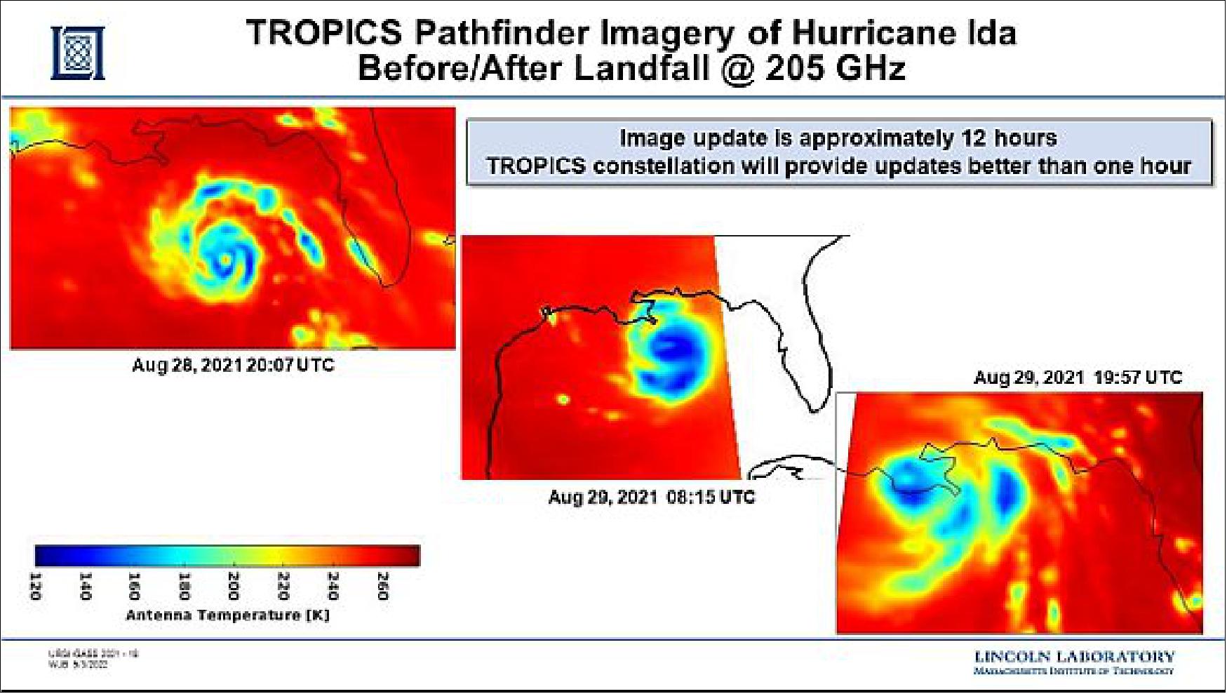
- TROPICS Pathfinder also captured images of Hurricane Ida on August 28 and 29, just before and after the storm made landfall in Louisiana. Read the full story about these images on the NASA Applied Sciences website.
- "What the constellation will give us that we don't have today is higher revisit rates – so we'll be able to observe storms from space at microwave frequencies much more frequently than we can now," said Blackwell.
• September 1, 2021: In 2022, NASA will launch a constellation of six small satellites (smallsats) to improve our understanding of tropical cyclones and support NASA's TROPICS (Time-Resolved Observations of Precipitation structure and storm Intensity with a Constellation of Smallsats) mission. But before then, NASA launched the TROPICS pathfinder, a test satellite that aids the TROPICS mission by enabling full testing of the technology, communication systems, data processing, and data flow to application users in advance of the constellation's launch next year. After being in orbit for only two months, the satellite captured images of Hurricane Ida just before and after it made landfall in Louisiana. 13)
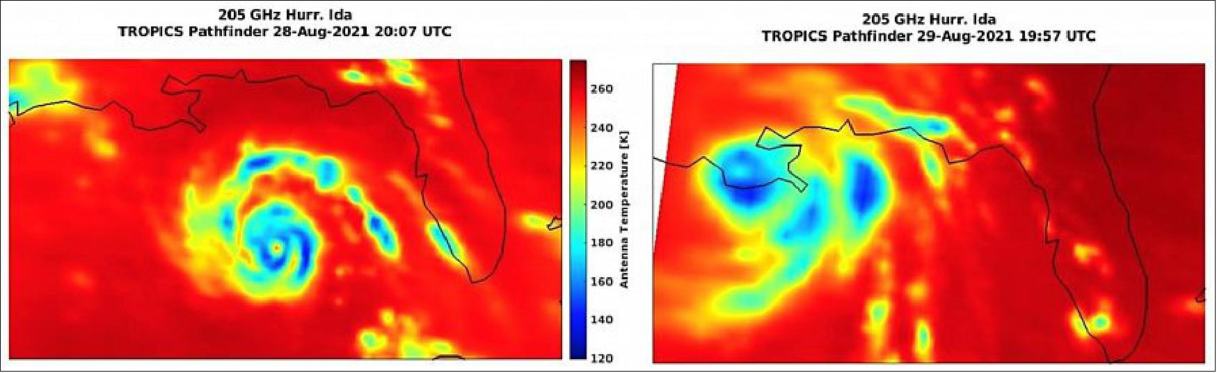
- Aboard the TROPICS pathfinder is an instrument called a microwave radiometer, which detects temperature, moisture, and rainfall in the atmosphere. The satellite's primary mission objective is to relate the structure of the atmospheric characteristics detected by the microwave radiometer to the evolution of tropical cyclone intensity – thus improving the accuracy of storm forecasts. The images of Hurricane Ida, captured at 205 GHz, provide researchers with a first look into how the completely new 205-GHz imaging channel works. "It's really great to see how well the 205-GHz imagery represents Ida's inner core," said Patrick Duran, TROPICS Applications Lead at NASA's Marshall Space Flight Center. "These initial images lend a lot of confidence that the data we receive from the imager will be useful in characterizing a hurricane's structure."
- One thing that really stands out in the Aug. 28 image is the big band of blues and greens most pronounced to the north and east of the storm, far from its inner core. That is a squall line – a line of thunderstorms – associated with a tropical cyclone's 24-hour cycle, which can cause severe weather far from the storm's center. Since TROPICS is a constellation of satellites, it will be able to collect data much more frequently over a given storm, enabling a more in-depth analysis of these squall lines and how they form.
• February 26, 2021: NASA has selected Astra Space Inc. to provide a launch service for the agency's Time-Resolved Observations of Precipitation Structure and Storm Intensity with a Constellation of SmallSats (TROPICS) mission. The TROPICS mission consists of a constellation of six CubeSats and will increase the scientific community's understanding of storm processes. 8)
- The launch service contract for the TROPICS mission is a firm fixed-price contract valued at $7.95 million. NASA's Launch Services Program at the agency's Kennedy Space Center in Florida will manage the launch service.
- The CubeSats, each the size of a shoebox, will provide rapid-refresh microwave measurements that can be used to determine temperature, pressure, and humidity inside hurricanes as they form and evolve. The TROPICS mission's high-revisit imaging and sounding observations are enabled by microwave technology developed at the Massachusetts Institute of Technology's Lincoln Laboratory. These observations will profoundly improve scientists' understanding of processes driving high-impact storms.
- Astra Space will launch the CubeSats on the company's Rocket 3 from Kwajalein Atoll in the Marshall Islands with three separate launches over a 120-day period. The TROPICS mission is targeted for launch between Jan. 8 and July 31, 2022, under a Federal Aviation Administration (FAA) launch license.
• June 30, 2021: The 2020 Atlantic hurricane season was one of the most brutal on record, producing an unprecedented 30 named storms. What's more, a record-tying 10 of those storms were characterized as rapidly intensifying — some throttling up by 100 miles per hour in under two days. 7)
- To bring more data to forecasters and have a more consistent watch over Earth's tropical belt where these storms form, NASA has launched a test satellite, or pathfinder, ahead of a constellation of six weather satellites called TROPICS (Time-Resolved Observations of Precipitation structure and storm Intensity with a Constellation of Smallsats). Planned for launch in 2022, the TROPICS satellites will work together to provide near-hourly microwave observations of a storm's precipitation, temperature, and humidity – a revisit time for these measurements not currently possible with other satellites.
- "As a lifelong Floridian, I've seen firsthand the devastating impact that hurricanes can have on our communities. And as climate change is making hurricanes even stronger, it's more important than ever that NASA and our partners invest in missions like TROPICS to better track and understand extreme weather," said NASA Administrator Bill Nelson. "NASA's innovation is strengthening data models that help scientists improve storm forecasting and understand the factors that feed these monster storms. TROPICS will help to do just that and we look forward to next year's launch of the TROPICS satellite constellation."
- "TROPICS is the beginning of a new era. This mission will be among the first to use a constellation of small satellites for these types of global, rapid-revisit views of tropical storms," said Scott Braun, the TROPICS project scientist and a research meteorologist at NASA's Goddard Space Flight Center in Greenbelt, Maryland.
- Since tropical cyclones and hurricanes can change rapidly as they travel across the ocean, the increased observations from the TROPICS satellites will not only advance the science of understanding storm intensity, they also may improve intensity forecasts.
- "The project holds great promise to boost NOAA's steady improvements in weather and hurricane forecasts by feeding new environmental data into our world-class numerical weather prediction models," said Frank Marks, director of the Hurricane Research Division of NOAA's Atlantic Oceanographic and Meteorological Laboratory. After all six satellites are launched and positioned in 2022, "this new constellation will provide high frequency temperature and humidity soundings as we seek to learn how hurricanes interact with the surrounding temperature and moisture environment—key data that could improve hurricane intensity forecasts."
- A critical step to preparing for the constellation is the launch of a pathfinder satellite, a seventh identical copy of the TROPICS smallsats, that will enable full testing of the technology, communication systems, data processing, and data flow to application users in advance of the constellation's launch. This will allow time for adjustments to the ground system and data products, helping ensure the success of the TROPICS mission.
- "The TROPICS Pathfinder satellite is similar to a screening before the opening night of a big show," said Nicholas Zorn, the Pathfinder program manager from MIT Lincoln Laboratory. "Its mission is a real-world, end-to-end test, from environmental verification through integration, launch, ground communications, commissioning, calibration, operations, and science data processing. Any areas for improvement identified along the way can be reinforced before the constellation launches."
- MIT Lincoln Laboratory's William Blackwell is the TROPICS principal investigator. Six years ago, he submitted TROPICS as a proposal to NASA's Earth Venture Instrument competition series and was awarded funding. The Earth Venture Instrument program calls for innovative, science-driven, cost-effective missions to solve pressing issues related to Earth science.
- Aboard each TROPICS small satellite is an instrument called a microwave radiometer, which detects temperature, moisture, and rainfall in the atmosphere. On current weather satellites, microwave radiometers are about the size of a washing machine. On TROPICS' small satellites the radiometers are about the size of a coffee mug.
- Microwave radiometers work by detecting the thermal radiation naturally emitted by oxygen and water vapor in the air. The TROPICS instrument measures these emissions via an antenna spinning at one end of the satellite. The antenna listens in at 12 microwave channels between 90 to 205 GHz, where the relevant emission signals are strongest. These channels capture signals at different heights throughout the lowest layer of the atmosphere, or troposphere, where most weather we experience occurs.
- By flying the TROPICS radiometers at lower altitude and detecting fewer channels than their larger counterparts, in the channels they do carry, the radiometers deliver comparable performance.
- Miniaturizing the microwave radiometer has been an incremental process over the last 10 years for Blackwell and his team, spurred by the invention of CubeSats, satellites the size of a loaf of bread that are often economical to launch. TROPICS builds on Blackwell and his team's 2018 success in launching the first microwave radiometer on a CubeSat to collect atmospheric profiling data. The instrument aboard the TROPICS' six satellites has been upgraded to provide improved sensitivity, resolution and reliability and will make more targeted and rapid weather observations.
- "These storms affect a lot of people, and we expect that with the increased observations over a single storm from TROPICS, we will be able to improve forecasts, which translates to helping people get to safety sooner, protect property, and overall enhance the national economy," Blackwell says, looking ahead to the full constellation launch next year. "It is amazing technology that we have proven out that allows us to maximize the science from the instrument's size factor. To pull this off has taken contributions of so many people."
- The TROPICS science team includes researchers from MIT Lincoln Laboratory and MIT Department of Aeronautics and Astronautics; NASA's Goddard Space Flight Center; NOAA Atlantic Oceanographic and Meteorological Laboratory; NOAA National Hurricane Center; NOAA National Environmental Satellite, Data, and Information Service; University of Miami; Colorado State University; Vanderbilt University; and University of Wisconsin. The University of Massachusetts Amherst, Texas A&M University and Tufts University contributed to the technology development. Maverick Space Systems provided integration services for the Pathfinder, which was launched from SpaceX's Transporter 2 mission. Astra Space Inc. is providing launch services for the constellation. NASA's Launch Services Program based at Kennedy Space Center procured and is managing the Tropics Pathfinder launch service.
• September 7, 2020: Momentus launch provider of Santa Clara, CA, has announced a service agreement with NASA to transport the TROPICS Pathfinder CubeSat to LEO no later than 30 June 2021. The TROPICS Pathfinder CubeSat in the Planetary System Corporation 3U Canisterized Satellite Dispenser will be integrated onto Momentus' Vigoride transfer vehicle currently scheduled to launch on a SpaceX Falcon-9 dedicated rideshare mission. 9)
• The first TROPICS application workshop was held at the University of Miami, Miami, Florida, USA on 8-10 May 2017.
• NASA selected the mission as the winning proposal for the Earth Venture1–Instrument (EVI-3) Announcement of Opportunity in 2016. William Blackwell of MIT/LL (Massachusetts Institute of Technology/Lincoln Laboratory) is the principal investigator for TROPICS. 10)
Sensor Complement
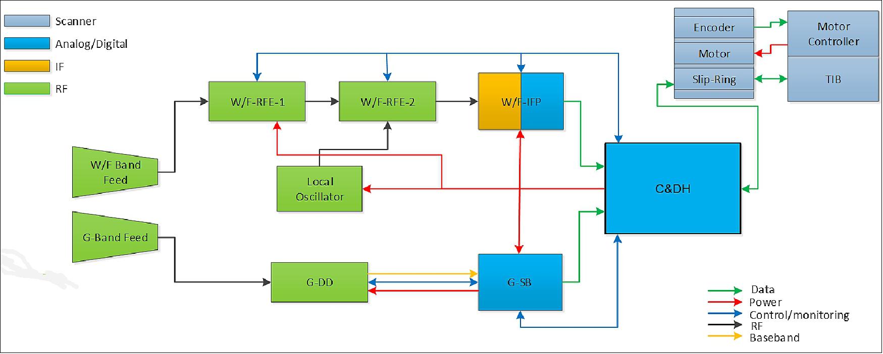
TROPICS will fly two total power radiometers that measure 12 channels spanning approximately 90 to 206 GHz. The "WF-band" radiometer comprises eight channels from 90–119 GHz, and the "G-band" radiometer comprises four channels from 183–206 GHz. The radiometer block diagram is shown in Figure 11. The specific channel properties are shown in Table 2. The full-width at half maximum antenna beamwidths are achieved using an offset parabolic reflector illuminated with two electroformed feed horns that are physically separated, and the beams are combined and collocated using a polarizing wire grid diplexer. 14)
Channel | Center Frequency (GHz) | Bandwidth (MHz) | Beamwidth (º) Down/Cross | NEDT | Cal. Acc. (K) |
1 | 91.655 ± 1.4 | 1000 | 3.00/3.17 | 0.95 | 2.0 |
2 | 114.50 | 1000 | 2.4/2.62 | 0.55 | 1.5 |
3 | 115.95 | 800 | 2.4/.2.62 | 0.60 | 1.5 |
4 | 116.65 | 600 | 2.4/.2.62 | 0.70 | 1.5 |
5 | 117.25 | 600 | 2.4/.2.62 | 0.70 | 1.5 |
6 | 117.80 | 500 | 2.4/.2.62 | 0.75 | 1.5 |
7 | 118.24 | 380 | 2.4/.2.62 | 0.85 | 1.5 |
8 | 118.58 | 300 | 2.4/.2.62 | 1.00 | 1.5 |
9 | 184.41 | 2000 | 1.5/1.87 | 0.60 | 1.0 |
10 | 186.51 | 2000 | 1.5/1.87 | 0.60 | 1.0 |
11 | 190.31 | 2000 | 1.5/1.87 | 0.60 | 1.0 |
12 | 204.8 | 2000 | 1.4/1.76 | 0.60 | 1.0 |
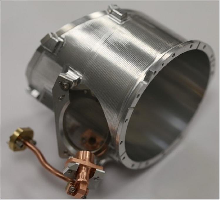
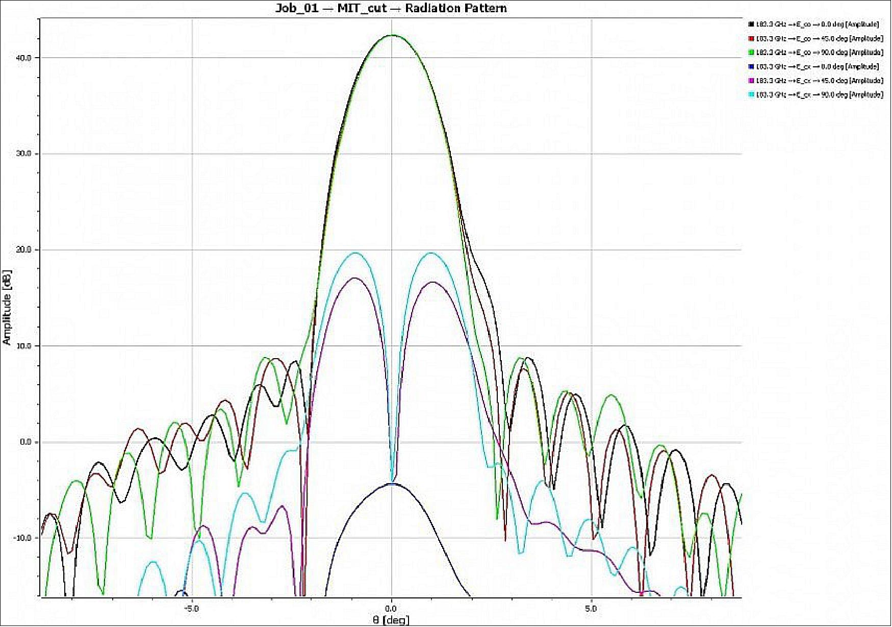
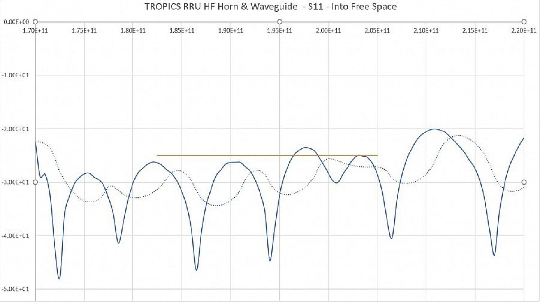
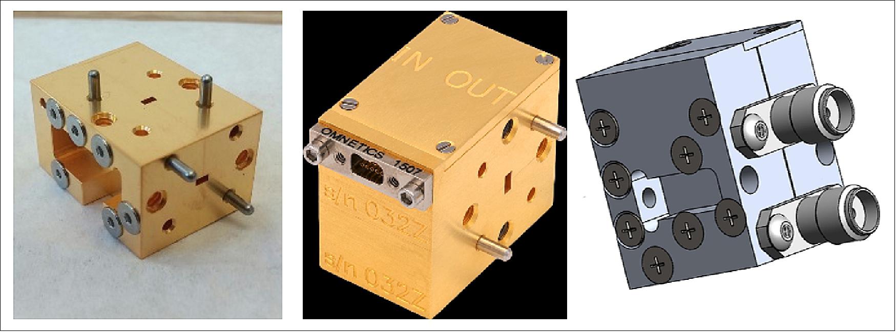
The antenna engineering model is shown in Figure 12. Beam efficiencies for the temperature and water vapor sounding channels are designed to exceed 95%. The simulated G-band antenna patterns are shown in Figure 13 and measured return loss of the G-band feedhorn is shown in Figure 14. Excellent performance is indicated in both the pattern and return loss data. Radiometer calibration is accomplished using weakly coupled noise diodes with known and stable noise output that are turned on and off against the cold space background. Satellite intercalibration is optimized using cross comparisons (15)) and daily calculated numerical model residuals (16)) to derive and implement any needed bias corrections. The W/F-band receiver assembly is shown in Figure 15. A custom SiGe MMIC was developed at UMass-Amherst to provide and RF amplifier, mixer, and IF preamplifier in a highly integrated package.
The radiometer operates in an "integrate-while-scanning" mode that results in elongated footprints in the cross-track direction. The spatial resolution is thus reported as the geometric mean of the minor and major axes of the ellipse projected on the earth, also accounting for earth curvature. As the constellation of six satellites scans the earth, the footprints near the edge of the scan are revisited more often than the footprints near nadir. This is effect is quantified by calculating an "effective" spatial resolution that weights the spatial resolution of each footprint by the relative frequency by which it is revisited. The nadir, mean-across-scan, and effective spatial resolutions are shown in Table 3. The satellite pointing accuracy and sensor mounting requirements are set to ensure geolocation errors are smaller than approximately 10% of the footprint size.
Band | Nadir (km) | Scan Mean (km) | Effective Across Scan (km) |
W (90 GHz) | 29.6 | 42.9 | 50.7 |
F (118 GHz) | 24.1 | 34.9 | 41.2 |
G (183 GHz) | 16.1 | 23.3 | 27.5 |
G (205 GHz) | 15.2 | 22.1 | 26.0 |
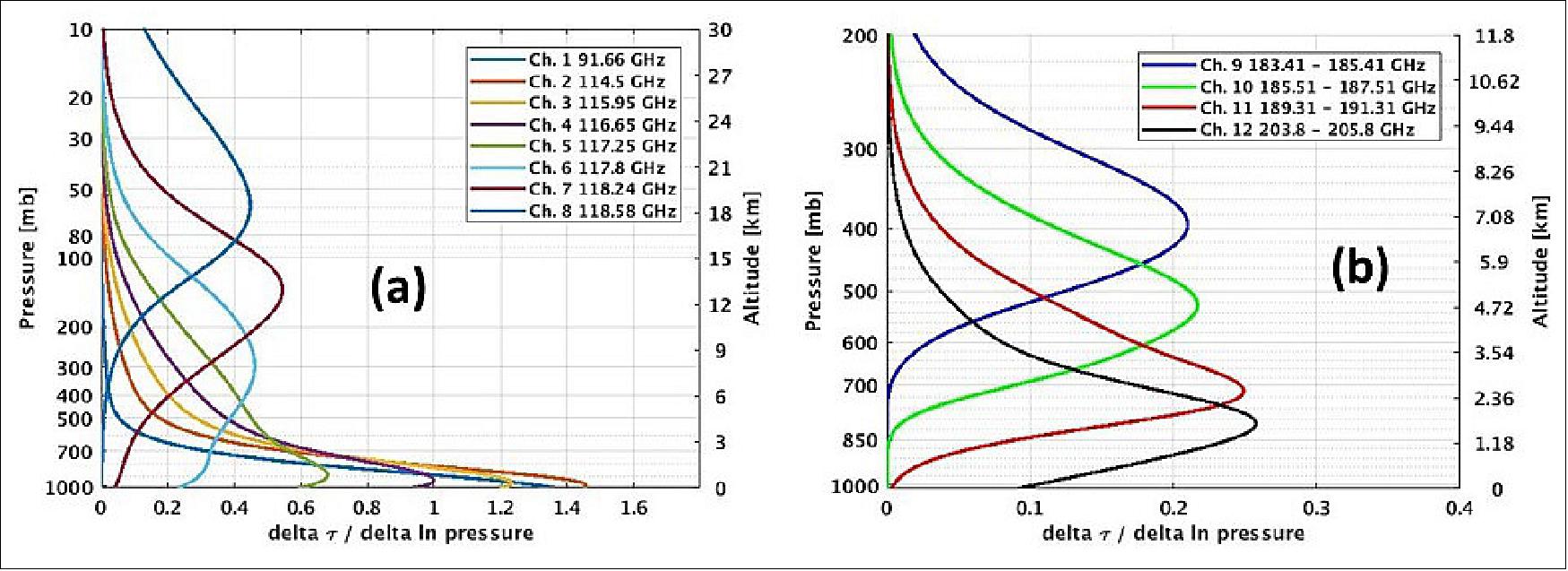
The temperature weighting functions for all 12 TROPICS channels are shown in Figure 16. Channel passbands are designed to span altitudes from the surface up to 20 km for temperature and 10 km for water vapor. Multiple temperature channels probe the upper troposphere to observe tropical cyclone warm core anomalies.
TROPICS summary: TROPICS will be the first demonstration that science payloads on low-cost CubeSats can push the frontiers of spaceborne monitoring of the Earth to enable system science and will fill gaps in our knowledge of the short time scale — hourly and less — evolution of tropical cyclones, where current capabilities are an order of magnitude slower. The TROPICS mission will implement a spaceborne earth observation mission designed to collect measurements over the tropical latitudes to observe the thermodynamics and precipitation structures of TCs over much of the storm lifecycle. The measurements will provide nearly all-weather observations of 3D temperature and humidity, as well as cloud ice and precipitation horizontal structure. These measurements and the increased temporal resolution provided by the CubeSat constellation, are needed to better understand the TC lifecycles and the environmental factors that affect the intensification of TCs (Ref. 3).
Ground Stations
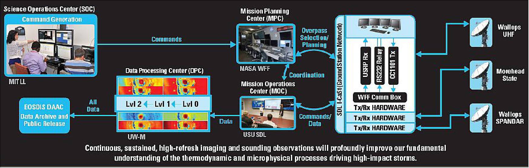
The TROPICS 3U CubeSats will interface with the KSAT-lite ground station network to allow for satellite command and control and downlink of bus and payload telemetry for each CubeSat in the constellation.
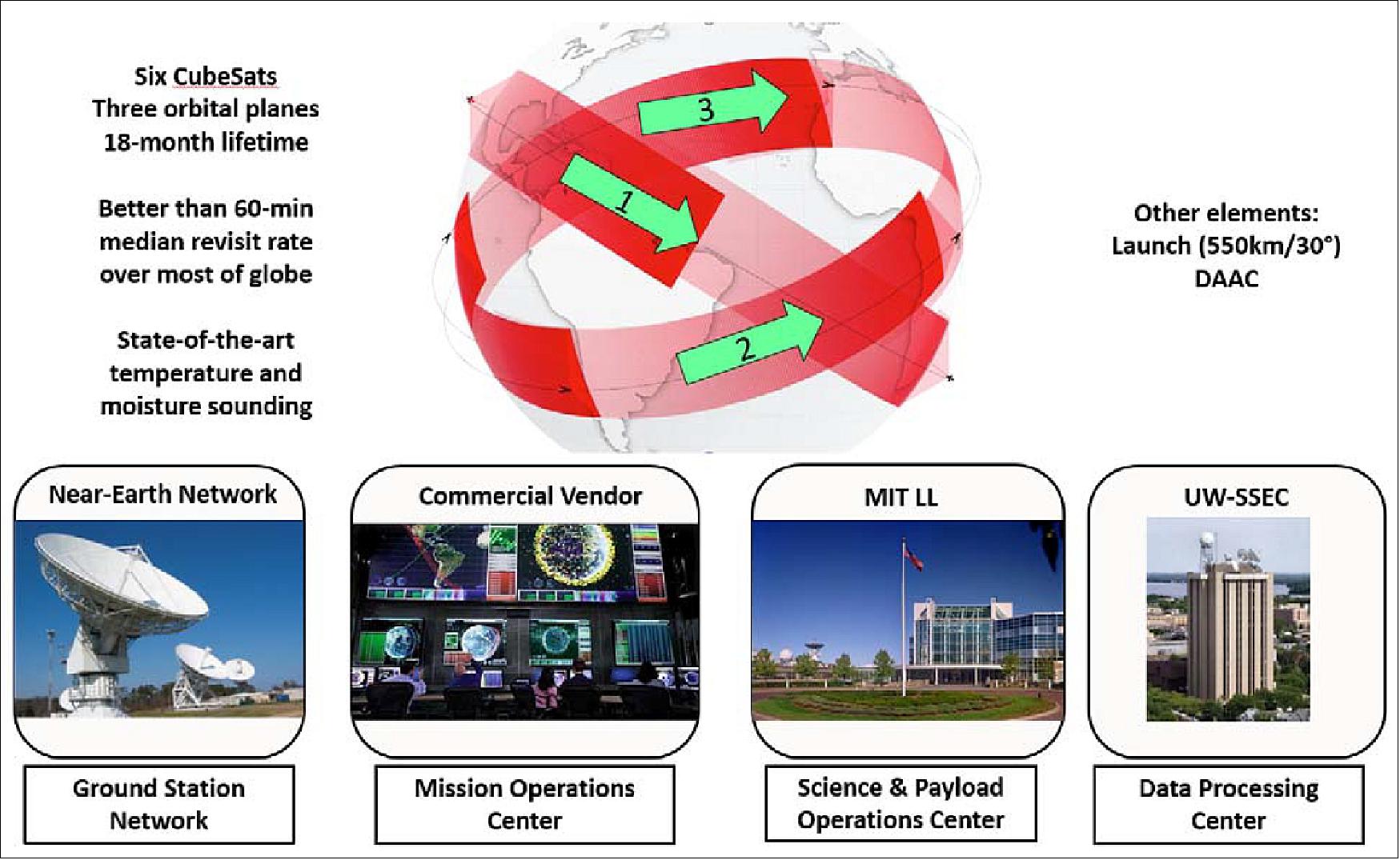
Data Processing: MIT/LL will interact with the mission operations provider to acquire the downlinked raw science data and format it into data products that can be shared with the data processing center at the University of Wisconsin. The data products will be made available to the data processing center via a secured connection. The data will be stored at MIT/LL in a SQL database on a MIT/LL computer system that includes disk redundancy and data backups. The entire mission data set will be stored at MIT/LL for the duration of the TROPICS project. The key elements of the TROPICS mission are shown in Figure 17.
References
1) Steve Cole, "NASA Selects Instruments to Study Air Pollution, Cyclones," NASA/JPL News, March 10, 2016, Release 16-025, URL: https://www.nasa.gov/press-release/nasa-selects-instruments-to-study-air-pollution-tropical-cyclones
2) W. Blackwell, D. Burianek, K. Clark, D. Crompton, A. Cunningham, L. Fuhrman, P. Hopman, S. Michael, "The NASA TROPICS CubeSat Constellation Mission: Overview and Science Objectives," Proceedings of the 31st Annual AIAA/USU Conference on Small Satellites, Logan UT, USA, Aug. 5-10, 2017, paper: SSC17-VI-07, URL: http://digitalcommons.usu.edu/cgi/viewcontent.cgi?article=3640&context=smallsat
3) W. Blackwell, K. Clark, D. Cousins, D. Crompton, A. Cunningham, M. Diliberto, L. Fuhrman, R. Leslie, I. Osaretin, S. Michael, "New Capabilities for All-Weather Microwave Atmospheric Sensing Using CubeSats and Constellations," Proceedings of the 32nd Annual AIAA/USU Conference on Small Satellites, Logan UT, USA, Aug. 4-9, 2018, paper: SSC18-II-07, URL: https://digitalcommons.usu.edu/cgi/viewcontent.cgi?article=4074&context=smallsat
4) TROPICS NASA Fact Sheet, URL: https://tropics.ll.mit.edu/CMS/tropics/pdf/nasaTropicsFactSheet.pdf
5) "TROPICS," MIT, URL: https://tropics.ll.mit.edu/CMS/tropics/
6) "BCT Opening New Small Satellite Manufacturing Center, will Build CubeSat Constellation for NASA Hurricane Observation," Blue Canyon Technologies, 31 October 2017, URL: http://bluecanyontech.com/bct-opening-new-small-satellite-manufacturing-center-will-build-cubesat-constellation-nasa-hurricane-observation/
7) Kylie Foy, Ellen Gray, "Pathfinder Satellite Paves Way for Constellation of Tropical-storm Observers," NASA Feature, 30 June 2021, URL: https://www.nasa.gov/feature/esnt/2021/pathfinder-satellite-paves-way-for-constellation-of-tropical-storm-observers
8) Monica Witt, Josh Finch, Patti Bielling, "NASA Awards Launch Service Contract for TROPICS Mission to Study Storm Processes," NASA Contract Release C21-003, 26 February 2021, URL: https://www.nasa.gov/press-release/nasa-awards-launch-service-contract-for-tropics-mission-to-study-storm-processes
9) "Momentus awarded NASA TROPICS Pathfinder mission," Space Daily, 7 September 2020, URL: https://www.spacedaily.com/reports/Momentus_awarded_NASA_TROPICS_Pathfinder_mission_999.html
10) Bradley Zavodsky,, Jason Dunion, William Blackwell, Scott Braun, Chris Velden, Michael Brennan, "First TROPICS Applications Workshop Meeting Summary," The Earth Observer, November - December 2017, Volume 29, Issue 6, pp: 22-25, URL: https://eospso.nasa.gov/sites/default/files/eo_pdfs/Nov_Dec_2017_color_508.pdf
11) Danny Lentz, "SpaceX successfully launches Transporter 2 mission with 88 satellites," NASA Spaceflight.com, 30 June 2021, URL: https://www.nasaspaceflight.com/2021/06/spacex-f9-transporter-2-rideshare/
12) Sofie Bates, "NASA's TROPICS Pathfinder Satellite Produces Global First Light Images and Captures Hurricane Ida," NASA Feature, 13 September 2021, URL: https://www.nasa.gov/feature/esnt/goddard/2021/nasa-s-tropics-pathfinder-satellite-produces-global-first-light-images-and-captures
13) Gabriella Lewis, "NASA Test Satellite Provides Insight into Hurricane Ida," NASA News, 1 September 2021, URL: https://appliedsciences.nasa.gov/our-impact/news/nasa-test-satellite-provides-insight-hurricane-ida
14) William J. Blackwell, "Design and performance of the TROPICS radiometer components," Proceedings of IGARSS (International Geoscience and Remote Sensing Symposium), Valencia, Spain, July 23-27, 2018
15) Sayak K. Biswas, Spencer Farrar, Kaushik Gopalan, Andrea Santos-Garcia, W. Linwood Jones, Stephen Bilanow, "Intercalibration of Microwave Radiometer Brightness Temperatures for the Global Precipitation Measurement Mission," IEEE Transactions on Geoscience and Remote Sensing, Vol. 51, No. 3, pp: 1465-1477, March 2013, URL: [web source no longer available]
16) R. W. Saunders, T. A. Blackmore, B. Candy, P. N. Francis, T. J. Hewison, "Monitoring Satellite Radiance Biases Using NWP Models." IEEE Transactions on Geoscience and Remote Sensing, Vol. 51, No. 3, pp. 1124-1138,March 2013
17) Jeff Foust, "Astra launch of NASA TROPICS cubesats fails," Space News, 12 June 2022, URL: https://spacenews.com/astra-launch-of-nasa-tropics-cubesats-fails/
18) "NASA Awards Launch Services Task Order for TROPICS CubeSats Mission," NASA TV, 23 November 2022, URL: https://www.nasa.gov/press-release/nasa-awards-launch-services-task-order-for-tropics-cubesats-mission
19) "NASA and Astra modify TROPICS launch contract," Space News, 29 September 2022, URL: https://spacenews.com/nasa-and-astra-modify-tropics-launch-contract/
20) Wikipedia, “TROPICS (spacecraft constellation)”. URL: https://en.wikipedia.org/wiki/TROPICS_(spacecraft_constellation)
The information compiled and edited in this article was provided by Herbert J. Kramer from his documentation of: "Observation of the Earth and Its Environment: Survey of Missions and Sensors" (Springer Verlag) as well as many other sources after the publication of the 4th edition in 2002. - Comments and corrections to this article are always welcome for further updates (eoportal@symbios.space).
Space Vehicles Launch Mission Status Sensor Complement Ground Segment References
Back to top