SIR-B (Shuttle Imaging Radar-B)
Earth Observation
SIR-B (Shuttle Imaging Radar-B) / OSTA-3 Payload on STS-41G Mission
The OSTA-3 (Office of Space and Terrestrial Applications) payload of NASA was the second in a series of Earth observation payloads that flew on the Shuttle. It flew on STS 41-G. The mission objectives were to:
• Evaluate the utility of advanced remote-sensing systems for various types of Earth observations
• Use remote observations of Earth's surface and its atmosphere to improve the current understanding of surface processes and environmental conditions on Earth
The main OSTA-3 payload consisted of three experiments:
• SIR-B (Shuttle Imaging Radar-B), the prime payload of the mission, was a NASA/JPL developed payload assembly
• MAPS (Measurement of Air Pollution From Satellites)
• FILE (Feature Identification and Landmark Experiment).
An international team of scientists participated in the mission, conducting scientific investigations in geology, renewable resources, oceanography, and calibration techniques.
Launch
The STS-41G mission (Challenger) was launched on Oct. 5, 1984 (duration: 1 week, landing on Oct. 13, 1984). The ERBS (Earth Radiation Budget Satellite) spacecraft of NASA was part of the mission; ERBS (primary payload) was deployed by the crew on the first day (using the Canadarm). 1)
Following the Shuttle launch, orbital insertion, and payload activation activities, the ERBS spacecraft was prepared for deployment. The ERBS deployment was delayed from orbit 6 to orbit 9 because of thermally induced problems that delayed deployment of the ERBS antenna. The deployment was accomplished with acceptable tipoff rates. On flight day 3, the initial ERBS maneuver (RCS cal burn) of 3 hours duration placed the ERBS spacecraft in an orbit of 415 km altitude. Subsequent planned burns successfully placed the ERBS spacecraft in its final orbit of 660 km altitude with an inclination of 57º.
Orbit: Shuttle orbit, 350 km x 390 km initial altitude, inclination of 57º, period of 92 min. Note: The Shuttle mission STS-41G was flown at three different orbital altitudes. Orbits 001 - 022 were flown at an average altitude of 352 km; orbits 023 - 036 were flown at an altitude of 272 km; and orbits 037 - 128 were flown at an altitude of 225 km. The objective was to test the SIR-B SAR observation performance from different altitudes and different inclination angles. 2)
Mission Status
SIR-B actually acquired only seven and a half hours of digital data and eight hours of optical data. Three problems affected the amount of data collected:
1) The Ku-band antenna gimbal failed. It could transmit only prerecorded tape data through the TDRSS (Tracking and Data Relay Satellite System) with special orbiter attitudes. This resulted in acquiring only 20% of the planned science data. Therefore, only fifteen investigators received sufficient data (50 to 75%) to meet their objectives, twenty-three investigators received a limited amount of data (10 to 50%), and six investigators received only a token amount of data.
2) The TDRSS link was lost for twelve hours, forty-two minutes during the mission.
3) Anomalies in the radio frequency feed system to the SIR-B antenna reduced transmitter power and, therefore, degraded the data.
Sensor Complement
OSTA-3 carried a modified version of the Shuttle Imaging Radar (SIR-B) and three other flight-proven instruments: LFC (Large Format Camera), MAPS (Measurement of Air Pollution from Satellites) and FILE (Feature Identification and Location Experiment). MAPS and FILE are described under SIR-A. These were re-flies of the sensors flown the OSTA-1 payload of the STS-2 mission.
The SIR-B payload was developed for the Office of Space Science and Applications by Charles Elachi (PI) and his team at NASA’s Jet Propulsion Laboratory, Pasadena, CA.
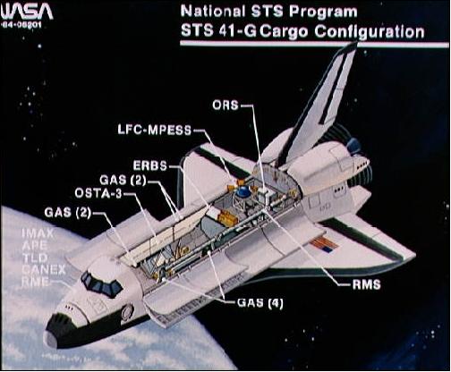
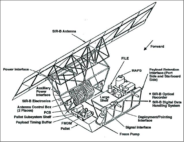
The OSTA-3 payload was mounted on a Spacelab pallet carrier in the payload bay. In addition, there were 8 GAS (Getaway Special) canisters, four middeck experiments and a series of experiments associated with Canada (CANEX). STS-41G was the 13th flight in the Space Shuttle program. Orbiter mass at liftoff of 110,127 kg, total payload mass of 10.643 kg (with OSTA-3 mass of 1.929 kg).
The objectives for OSTA-3 are to record photographic and radar images of the Earth's surface, to measure the global distribution of tropospheric carbon monoxide, and to attempt autonomous classification of scenes. The images will be used for making maps interpreting geological features and resource studies.
SIR-B (Shuttle Imaging Radar-B)
A reflight of an upgraded L-band SAR (Synthetic Aperture Radar) instrument as flown on the STS-2 mission - with the provision of a variable look angle of the SAR antenna. SIR-B provided for the first time the ability to mechanically tilt the SAR antenna over a range of 15 - 55º so that radar imagery from multiple angles of incidence could be obtained. The azimuth resolution was 25 m at all incidence angles; radiometric resolution = 3-6 bit on raw data.
Radar center frequency | 1.275 GHz (L-band) |
Radar wavelength | 23.5 cm |
System bandwidth | 12 MHz |
Range resolution | 58 to 16 m |
Azimuth resolution | 20 to 30 m (4-look) |
Swath width | 20 to 40 km |
Antenna dimension | 10.7 m x 2.16 m |
Antenna look angle | 15 to 65º from vertical |
Polarization | HH |
Transmitted pulse length | 30.4 µs |
Minimum peak power | 1.12 kW |
Data recorder bit rate (on the ground) | 30. 4 Mbit/s |
SIR-B built upon the lessons learned by the Seasat and SIR-A missions and was the next step in JPL's program of using imaging radar for Earth observations. The SIR-B radar instrumentation was significantly upgraded. It had the additional flexibility of imaging geometry, particularly the effect of incidence angle on radar backscatter. One additional panel was added to the SIR-B antenna, bringing its total length to 10.7 m (8 panels); again the antenna was mounted on the starboard side of the payload bay. The southern side of the track was also imaged during the SIR-B flight by rolling the shuttle 75º or yawing it 180º. A final improvement to the antenna was the ability to fold for launch in order to accommodate an additional deployable payload.
A SAR image scene consisted of the swath width of 30 - 60 km (depending on look angle and orbital altitude) x the length of the active radar track. A digital data handling assembly (DDHA) converted the analog signal to a digital signal on-board the Shuttle. The SAR source data were recorded onto HDRR (High Data Rate Recorder). SAR source data were also transmitted via a TDRS link. RF data transmission: Shuttle downlink via TDRS in Ku-band at a data rate of 40 Mbit/s. The digital data were downlinked via White Sands (NM) and via DomSat to NASA/GSFC. The digital tapes were then sent to JPL to be processed to imagery. The optical data were processed by an optical correlator at JPL. 3) 4) 5) 6)
Several problems severely impacted the SIR-B data collection time. These included the Ku-band antenna gimbal failure (this implied that prerecorded tape data transmissions through TDRS could only be made at special orbiter attitudes). This resulted in a TDRSS link loss for more than 12 hours. As a result, only a total of 7.5 hours of digital data and 8 hours of optically recorded data were acquired during the mission. (optical recording of the SAR data took place when problems with the Ku-band transmissions were encountered).
In 1992, radar images collected by SIR-B were used by archeologists to locate the lost city of Ubar in the country of Oman on the Saudi Arabian peninsula.
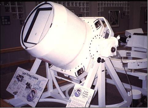
LFC (Large Format Camera)
LFC was a NASA experimental camera based on analog film (PI: B. H. Mollberg), built by Itek Optical Systems (Div. of Litton Systems Inc.), Lexington, MA. The objective was to evaluate the utility of orbital photography for cartographic mapping and land use studies at scales of 1:50,000. 7) 8)
The LFC payload consisted of a camera system mounted inside the Shuttle cargo bay. The film magazine was preloaded with 2400 frames of five different types of 23 cm x 46 cm format high definition film (color-infrared, natural color, and three types of black and white film). In addition, LFC employed ARS (Attitude Reference System), consisting of two orthogonal cameras with 152 mm focal lengths, recording the star field at the point in time of each LFC acquisition of the Earth's surface. The known star field permitted the attitude calculation of the LFC in the orbiter bay. This information was used to calculate the precise image location on Earth's surface to an accuracy of < 1 km.
The LFC assembly had a total mass of 1550 kg (the camera itself had a mass of 450 kg), a single frame covered a surface area of about 60,000 km2; it was operated from the ground by NASA/JSC (Johnson Space Center) controllers.
Snapshot frame imagery was taken along the flight path for preselected target areas. To minimize smearing effects, the camera's film plate moved horizontally along the Shuttle's line of flight when the shutter was open. The film (total length of 1200 m) was driven by a forward motion compensation mechanism when exposed on a vacuum plate. A ground resolution of 10-20 m was achieved at altitudes of 200 to 250 km with standard photographic films. The LFC was able to obtain a forward overlapping stereoscopic coverage along the Shuttle's flight path with base-to-height ratios of 0.3, 0.6, 0.9, and 1.2.
A total of 2289 photographic frames were obtained, and the experiment was considered a success. However, the large and heavy LFC system did not make any reflights (because it required dedicated payload-bay space, attitude-control fuel, and scheduled time, in contrast to hand-held photography). The LFC film products are distributed by the EROS Data Center, Sioux Falls, SD.
High-priority coverage of LFC imagery of Mt. Everest in Nepal was acquired. A special roll maneuver was performed during flight day 8 to obtain oblique photography of Hurricane Josephine off the eastern coast of the United States.
Spectral range | 400 - 900 nm |
Film resolution | 100 lines/mm at 1,000:1 contrast |
Lens focal length, lens aperture | 305 mm, f/6.0 |
Image (film) format | 23 cm x 46 cm (a large format) |
Exposure interval | 7.5 s |
Framing rate | 5 - 45 seconds |
FOV of lens system | 73.7º cross track; 41.1º along track |
Area coverage | 170 km x 340 km (at 225 km altitude) |
Kodak B/W (Neg.) | Panatomic-X Aerocon 3412 |
Kodak B/W (Neg.) | High definition aerial 3412 |
Kodak Color (Pos.) | High definition aerial 3412 |
Kodak Color (Pos.) | Aerial Color SO-242 |
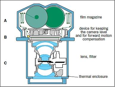
The LFC consists of:
• A - a magazine containing 1220 m of high-resolution film configured for 2400 images in a 460 mm along track x 230 mm across track format. These rather unusual dimensions support acquisition of images covering ground areas of 153 181 km2 (553 km x 277 km) from an altitude of 370 km.
• B - devices for keeping the camera perfectly level during exposure and for compensating forward motion.
• C - a lens with a focal length of 305 mm and an angular aperture of 74°. In addition, the ARS (Altitude Reference System), comprising two cameras with 152 mm focal lengths, records the star field at the point in time of each acquisition. Simultaneous collection of data concerning the satellite’s altitude and position makes for highly precise mapping.
Auxiliary Payloads
Other payloads on the STS-41G Shuttle flight included several additional experiments (which can only be described partially in this article due to a lack of proper references). 10) 11)
The middeck experiments were the IMAX camera, the APE (Auroral Photographic Experiment), the RME (Radiation Monitoring Experiment), and the TLD (Thermoluminescent Dosimeter).
• IMAX camera, flying for the third time.
• CANEX (Canadian Experiment) package. The CANEX experiments consisted of five activities and these were the: VISET (Space Vision System Experiment Development Tests), the ACOMEX (Advanced Composite Materials Exposure), the OGLOW (Orbiter Glow and Atmospheric Emissions) measurements, the SPEAM (Sun Photometer Earth Atmosphere Measurements), and the SASSE (Space Adaptation Syndrome Supplemental Experiments).
• APE (Auroral Photography Experiment). APE consisted of crew-conducted photography from the aft flight deck to document Orbiter encounters with the auroral zone. The experiment used standard 35 mm camera equipment supplemented by a USAF-provided image intensifier and filter assembly. Results obtained from STS -41G are over 200 excellent photographs showing the Earth's aurora and Orbiter glow. These photographs were subsequently analyzed by the USAF Geophysics Laboratory to determine the extent and duration of Orbiter exposure to the high-energy electron flux which creates the Earth's aurora. All activities on STS- 41G were a complete success.
• RME (Radiation Monitoring Equipment). The RME consists of hand-held and pocket-sized monitors which measure the level of background radiation present at various times in orbit. The two devices are self-contained and are powered by 9-volt alkaline batteries. At appointed times, the crew took and recorded measurements of any radiation which penetrates the cabin. RME devices have flown on several previous flights and are part of long-term studies of radiation exposure during spaceflight.
• TLD (Thermoluminescent Dosimeter) provided by Hungary. The six dosimeters were unstowed and located next to the United States PRDs (Passive Radiation Dosimeters) at about 3 hours into the mission. The dosimeters were then collected and read at six different times during the flight. There were no problems or anomalies reported. The postflight results indicate that the TLD measurements were in excellent agreement with the PRDs.
• GAS (Get Away Specials) total of 8 canisters.
• ORS (Orbital Refueling System). The ORS contained ~86 kg of hydrazine and a total of six transfers were successfully completed with no anomalies. An EVA (Extra Vehicular Activity) was used to safely attach a flexline to a typical satellite valve in the payload hardware. Following the EVA, the system was safely leak tested and approximately 60 kg of hydrazine were transferred through the valve. No anomalies were encountered during the EVA and the crew safely accomplished the tasks with no hydrazine contamination. The data acquired during the transfers have been evaluated. The successful accomplishment of the transfers demonstrated the feasibility of on-orbit refueling of satellites from an ORS-type tanker system.
References
1) “Space Shuttle Mission STS-41G,” NASA Press Kit, October 1984, URL: http://www.shuttlepresskit.com/sts-41g/sts41g.pdf
2) J. Cimino, C. Elachi, M. Settle, “ SIR-B-The Second Shuttle Imaging Radar Experiment,” IEEE Transactions on Geoscience and Remote Sensing, Vol. GE-24, Issue 4, July 1986, pp. 445-452
3) SIR-B 1985, URL: http://southport.jpl.nasa.gov/scienceapps/sirb.html
4) C. Elachi, J. Cimino, M. Settle, “Overview of the Shuttle Imaging Radar-B preliminary scientific results,” Science, Vol. 232, 1986, pp. 1511-1516,
5) http://www.jpl.nasa.gov/news/fact_sheets/radar.pdf
6) Lisa Gaddis, Pete Mouginis-Mark, Robert Singer, Verne Kaupp, “Geologic analyses of Shuttle Imaging Radar (SIR-B) data of Kilauea Volcano, Hawaii,” Geological Society of America Bulletin, Vol. 101, pp. 317-332, March 1989, URL: http://www.higp.hawaii.edu/~pmm/Gaddis_GSA.pdf
7) B. H. Mollberg, B. B. Schardt, “Mission Report on the Orbiter Camera Payload System (OCPS) Large Format Camera (LFC) and Attitude Reference System (ARS),” 1988, Johnson Space Center, JSC-23184
8) F. El-Baz, “New Mapping-Quality Photographs of the Earth and Their Applications to Planetary Comparisons,” Lunar and Planetary Science XVI, 1985, pp. 207-208; http://adsbit.harvard.edu/cgi-bin/nph-iarticle_query?1985LPI....16..207E&data_type=PDF_HIGH&type=PRINTER&filetype=.pdf
9) Fernand Verger, Isabelle Sourbès-Verger, Raymond Ghirardi, “The Cambridge Encyclopedia of Space- Missions Applications and Exproration,” Cambridge University Press, ISBN 0 521 77300 8 hardback, p. 8, URL: http://assets.cambridge.org/97805217/73003/sample/9780521773003ws.pdf
10) Space Applications, Vol. 6, Chapter 2, “NASA Historical Data Book,” URL: http://history.nasa.gov/SP-4012/vol6/vol_vi_ch_2.pdf
11) M. A. Collins Jr., A. D. Aldrich, G. S. Lunney, “STS41-G National Space Transportation Systems Program Mission Report,” JSC-20168, Nov. 1984, URL: http://ntrs.nasa.gov/archive/nasa/casi.ntrs.nasa.gov/19920075377_1992075377.pdf
The information compiled and edited in this article was provided by Herbert J. Kramer from his documentation of: ”Observation of the Earth and Its Environment: Survey of Missions and Sensors” (Springer Verlag) as well as many other sources after the publication of the 4th edition in 2002. - Comments and corrections to this article are always welcome for further updates (eoportal@symbios.space).