NigeriaSat-2
EO
Imaging multi-spectral radiometers (vis/IR)
High resolution optical imagers
Land
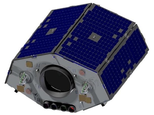
Launched in August 2011, NigeriaSat-2 is a Nigerian government imaging satellite and successor to NigeriaSat-1, produced by SSTL (Surrey Satellite Technology Ltd.) under a contract with the National Space Research and Development Agency (NASRDA) of Nigeria. It aims to provide high-resolution imagery of the Earth’s surface, with applications in supporting food security and agricultural data collection, mapping and security, as well as the provision of data continuity for the NigeriaSat-1 system.
Quick facts
Overview
| Mission type | EO |
| Agency | NASRDA |
| Mission status | Operational (extended) |
| Launch date | 17 August 2011 |
| Measurement domain | Land |
| Measurement category | Multi-purpose imagery (land), Albedo and reflectance |
| Measurement detailed | Land surface imagery, Earth surface albedo |
| Instruments | NigeriaSat Medium Resolution, NigeriaSat 2 Remote Sensing (Med and High Res) |
| Instrument type | Imaging multi-spectral radiometers (vis/IR), High resolution optical imagers |
| CEOS EO Handbook | See NigeriaSat-2 summary |
Summary
Mission Capabilities
The NigeriaSat-2 sensor complement consists of two instruments, the Medium Resolution Imager (MRI) and the Very High Resolution Imager (VHRI). The VHRI instrument is a 5 channel high resolution optical imager that utilises a steerable pushbroom scanning technique. The instrument design is derived from the China Mapping Telescope (CMT) flown aboard the Beijing-1 satellite, and is highly applicable in observation of vegetation and land cover for agricultural and geological purposes, as well as high resolution mapping and disaster observation. The MRI instrument is a 4-channel high resolution optical imager, and is a modified version of SLIM6 (Surrey Linear Imager Multispectral 6 channels), flown on the 1st generation DMC (Disaster Monitoring Constellation) missions, including NigeriaSat-1, with identical applications to the VHIR instrument.
Performance Specifications
The VHRI sensor operates across 4 multispectral bands (Blue, Green, Red, Near-Infrared (NIR)), with one panchromatic imaging channel. VHRI is capable of imaging at a spatial resolution of 2.5m for panchromatic imaging, and 5m for multispectral imaging. The instrument has a field-of-regard of 1200km, and an imaging swath of 20km. MRI also operates in 4 multispectral bands (Blue, Green, Red, NIR), but does not have panchromatic imaging capabilities. This sensor has a spatial resolution of 32m across all bands with an imaging swath of 300km.
NigeriaSat-2 operates in a sun-synchronous orbit of 718km, with an inclination of 98.24°. It has an orbital period of 99.5 min, and an equatorial nodal crossing time of 1015 hours LTAN (Local Time on Ascending Node).
Space and Hardware Components
NigeriaSat-2 utilises a minisatellite bus, the SSTL-300 , with a launch mass of 286 kg. The SSTL-300 bus is 3-axis stabilised, using an Altitude and Orbital Control Subsystem (AOCS) that consists of four Microwheel 10SP momentum wheels, to continuously maintain pointing, alongside four SSTL Smallwheel 200SP wheels, used as zero-momentum reaction wheels, enabling 0.35°/s2 acceleration and a slew rate of 6°/s. NigeriaSat-2 has two SGR-10 (Space GPS Receiver-10) units, to provide PVT (Position, Velocity, Time) data points. This allows the satellite to predict its own orbital trajectory, preempting pointing manoeuvres and geolocate collected images through measurement of payload position and altitude at the time of capture. In terms of radio-frequency communications, NigeriaSat-2 has 16 gigabytes of onboard storage capacity, and payload data is dowlinked in X-band transmissions of up to 210 Mbit/s, using dual X-band links of 105 Mbit/s.
N2 (NigeriaSat-2)
Overview Spacecraft Launch Mission Status Sensor Complement Ground Segment References
In November 2006, NASRDA (National Space Research and Development Agency) of Abuja, Nigeria awarded a contract to SSTL (Surrey Satellite Technology Ltd.) of Guildford, UK, to develop and build NigeriaSat-2, including the related ground infrastructure and image processing facilities, together with an extensive training program to further develop an indigenous space capability in the Federal Republic of Nigeria. NASRDA is an agency under the Federal Ministry of Science and Technology of Nigeria established in 1999.
The objective of the NigeriaSat-2 mission is to provide high-resolution (Pan and MS) imagery in a swath width of 20 km. In addition, the spacecraft also carries a DMC continuity payload to provide observation continuity with NigeriaSat-1, launched in September 2003. - The imagery of both spacecraft will serve as a catalyst to the development of Nigeria's NGDI (National Geospatial Data Infrastructure) program. NASRDA will facilitate efficient production, management, dissemination and use of geospatial information for the attainment of the MDGs (Millennium Development Goals) and the 7-Point Agenda of the Nigerian Government. 1) 2) 3) 4) 5) 6) 7) 8) 9) 10)
The development of NigeriaSat-2 involves also on-the-job training of NASRDA engineers at SSTL. A total of 25 engineers were trained at SSTL, 11 of them have undergone a Master's Degree and obtained the technical know-how to operate the high-resolution minisatellite at NASRDA. The training program is considered a major benefit in capacity building for Nigeria's strive to a modern and industrialized economy. 11)
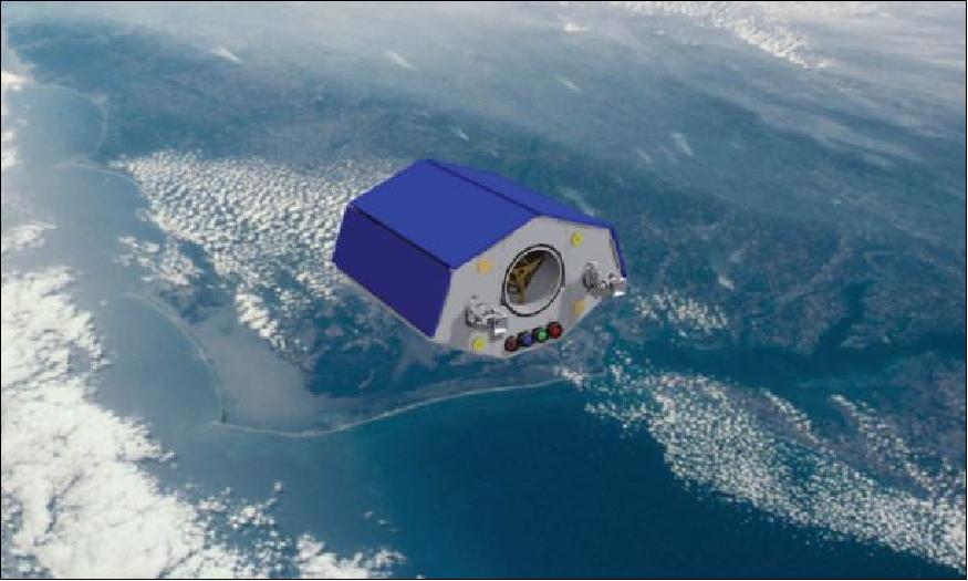
NigeriaSat-2 is designed with some key Nigerian objectives in mind:
• To support food supply security, agricultural and geology applications
• To support mapping and security applications
• To support development of the national GIS infrastructure
• To provide continuity and compatibility with the existing NigeriaSat-1 system.
These objectives place some key requirements on the system. In addition to requiring both medium and high resolution imaging capability, the satellite must also: a) provide timely global imaging access; b) deliver a high data throughput; c) support a number of special imaging modes; d) provide high accuracy geolocation knowledge of the imagery acquired; and e) be capable of fast slew maneuvers.
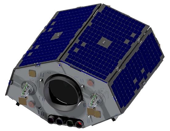
The satellite can be operated as a stand-alone system - but it has also the capability to interface with existing NASRDA systems (NigeriaSat-1) and to provide its services within the DMC (Disaster Monitoring Constellation) consortium.
SSTL completed the Mission Design Review of NigeriaSat-2 to the customer, NASRDA, in mid-April 2007.
Spacecraft
NigeriaSat-2 is a minisatellite of about 300 kg (the actual launch mass is 286 kg), based upon the new generation of high resolution Earth observation satellites. The newly developed bus is referred to as SSTL-300. The design takes full advantage of the latest advanced small satellite technologies developed from the recent and highly successful TopSat and Beijing-1 (DMC+4) missions (which have achieved over 10 years in-orbit heritage). The SSTL-300 bus is very agile and features a fast slew body-pointing capability of ±45º off nadir to increase the FOR (Field of Regard) for imaging coverage services. The design life of NigeriaSat-2 is 7 years (with a goal of up to 10 years). 12) 13) 14) 15) 16) 17)
The spacecraft is 3-axis stabilized. The AOCS (Attitude & Orbit Control Subsystem) builds on extensive heritage from previous SSTL missions but presents some new challenges in small satellite engineering. This mission demands both high accuracy and high agility, a combination that requires an advanced AOCS design. Sub-arcsec/sec platform stability is required to support co-registration of the imager bands so that a range of image products can be produced through automated ground processing. Yaw steering is also maintained during payload activity to counteract the effects of Earth rotation.
The primary actuators for attitude control are four Microwheel 10SP momentum wheels (RW type), used continuously to maintain pointing at the required attitude. In addition, four SSTL Smallwheel 200SP wheels (Figure 3) are used as zero-momentum reaction wheel to give this platform an acceleration capability of > 0.35º/s2 and a slew rate capability of > 6º/s. A 60º roll maneuver from -30º to +30º can be achieved in < 30 seconds. Roll and pitch maneuvers of this nature can then be used in quick succession to support the various imaging modes.
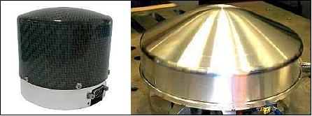
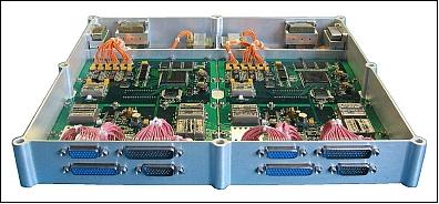
The SSTL-300 platform incorporates a pair of MIRaS-01 (MEMS Inertial Rate Sensor-01) modules, which it uses for supplementing star tracker measurements during high-rate slews for agile imaging operations. - After the BILSAT-1 flight experiment with the RRS01 (Range Rate Sensor-01) of AIS (Atlantic Inertial Systems, Plymouth, UK), SSTL decided to use the RRS01 MEMS device for its subsequent IS (Inertial Sensor) modules. The resulting MIRaS-01 module used on current SSTL missions is shown in Figure 4. 18)
The high agility of the spacecraft is achieved through the following features:
- Use of a compact spacecraft structure
- No liquid propellant. No deployable arrays
- Fast maneuvers can be performed with imaging immediately afterwards.
The RRS01 rate sensor bandwidth is > 50Hz, with most of the noise power concentrated at higher frequencies. The IS module processing board samples these sensors through a low-pass analogue filter with a bandwidth of 10Hz, which greatly reduces to the noise to 0.01ºs-1 Hz-1/2. Samples are taken at 10 Hz by an FPGA, which is able to output attitude rates at lower frequencies by time-averaging samples. This configuration gives a flat power spectral density below 10 Hz.
The MIRaS-01 takes advantage of the temperature sensors inside each RRS01 rate sensor to compensate for bias variation with temperature. With this in place the RMS variation is less than 180º/hour over the module's operating temperature range of -20ºC to +50ºC.
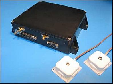
A redundant pair of SGR-10 (Space GPS Receiver-10) is used providing real-time PVT (Position, Velocity, Time) data. Each receiver has two antennas ensuring excellent coverage of the GPS constellation throughout the orbit and across the wide range of slew angles that NigeriaSat-2 allows. A recursive orbit estimator runs on the OBC that uses the GPS PVT data to maintain up-to-date estimates of the orbit ephemeris. This allows NigeriaSat-2 to accurately project forward its own trajectory and make timing and attitude corrections prior to image capture to ensure accurate targeting.
The SSTL-300 bus system is able to geolocate images of its target area to an accuracy of < 35 m (CE90 = Circular Error 90%) without using ground control points. This is achieved through precise measurement of the position and attitude of the payload at the time of image capture.
The minisatellite uses large body-mounted solar arrays for power generation. The two imaging payloads (VHRI, MRI) and the star cameras are being mounted onto a thermoelastic stable optical bench, which is supported by a compliant kinematic mount, to meet the pointing requirements of ~0.001º (Figure 17).
The thermal design of the SSTL-300 platform is mainly passive. The satellite therefore experiences significant changes in mean temperature and temperature gradients. The satellite primary structure is fabricated from aluminum skinned aluminum honeycomb core sandwich panels which distort as a result of the thermal environment.
Parameter / Spacecraft | NigeriaSat-1 | NigeriaSat-2 |
Spacecraft launch date | Sept. 27, 2003 (operational in 2012) | Aug. 17, 2011 |
Spacecraft mass at launch | 98 kg | < 270 kg |
SSO orbital altitude | 686 km | 700 x 733 km |
Propellant | Butane | Xenon |
Spacecraft design life | 5 years | 7.5 years |
AOCS | Gravity gradient stabilized | 3-axis stabilized using star cameras |
On-orbit data storage | 1 GByte (SSDR) | 16 GByte (hard drive storage) |
Swath width | 600 km | 300 km for 32 m resolution (MRI) |
Spacecraft pointing capability | ±30º | ±45º cone from nadir |
Imaging modes | Linear array | Scene, strip, area, and stereo |
Geolocation accuracy | ~ 300 m | 25-35 m |
Data transmission link | S-band | S-band, X-band |
OBC (On-board Computer) | 1 x 386, 1 x 186 | 4 x 386 |
Size of ground station dish | 3.7 m | 7.2 m |
Camera type | pushbroom imager | pushbroom imagers |
Camera | SLIM6 (2 banks of 3 bands each) | MRI (1 bank of 4 bands) |
Data resolution | 32 m | MRI: 32 m VHRI: 2.5 m (Pan), 5 m (MS) |
The SSTL-300 platform is a compact small satellite with the capability to support high-resolution imaging payloads. At the core of the spacecraft structure is a thermo-elastically stable optical bench (Figure 17), which is supported on a compliant kinematic mount. This ensures there are very low distortions between the star cameras and the imager boresight. On NigeriaSat-2 the optical bench is required to support both medium and high resolution imaging capability.
RF Communications
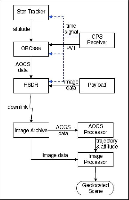
Onboard data storage in hard drive data storage with a capacity of 16 GByte (Figure 7). SSTL developed a new data recorder design, the HSDR (High Speed Data Recorder) which replaces the SSDR (Solid State Data Recorder). The HSDR is in-orbit reconfigurable, making it a very flexible and scalable part of the payload downlink chain. The HSDR employs a PowerPC processor, and solid state memory. 20)
Storage capacity | 16 GByte |
Inputs | 20 LVDS @ 150 Mbit/s |
Outputs | 10 LVDS @ 150 Mbit/s |
HSDR mass, volume | 1 kg, 300 mm x 150 mm x 30 mm |
Power | 15 – 50 V, 7 W standby, 23 W peak |
Radiation tolerance | 10 kRad (>7 years in LEO) |
In order to handle the very high data acquisition rates required to collect data from the VHRI instrument, the project decided to use the Xilinx Virtex-4 FPGA family, as this offered very high performance and had gained favorable results from third party radiation tests. In addition, the Virtex-4 is reconfigurable, potentially allowing for the FPGA configuration to be reconfigured in-orbit. This significantly increases the flexibility of the product as its firmware can be upgraded at a later date to modify its data processing capability.
Having been flown on at least nine missions, the SSDR has significant flight heritage. However, its storage capacity, data acquisition rate and data processing capability is limited. Just to meet the data storage requirements of NigeriaSat-2 it would have been necessary to utilize four SSDRs simultaneously. A DDR2 (Double Data Rate) SDRAM (Synchronous Dynamic Random-Access Memory) interface was selected for the HSDR. The use of high speed DDR2 memory contributes to the HSDR's exceptional data I/O processing capability, in excess of 5 Gbit/s.
As well as handling data flow, the HSDR also needed to operate a file system and SSTL's ARQ (Saratoga Automatic ReQuest) downlink system. Saratoga allows image data to be acquired and downlinked almost completely independently of the platform OBC (On Board Computer), whilst also allowing retransmission of any lost packets. The project implemented a separate microprocessor so that the HSDR would make use of the Virtex-4 FX variant's integral PowerPCs. This solution offers a sufficiently good BER and provides the possibility to operate the payload downlink chain in a "broadcast mode", with no ARQ. The advantage of broadcast mode is that no uplink is required to handle the ARQ; hence, the ground station setup is more straightforward.
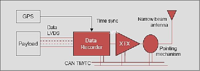
The payload data is downlinked in X-band at data rates of up to 210 Mbit/s (dual X-band links of 105 Mbit/s each, 6 W RF output power, modulation: BPSK or QPSK, mass = 3.25 kg). The main payload downlink elements are shown in Figure 11. 21) 22) 23)
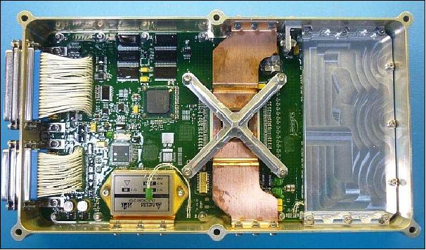
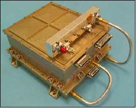
The XTx (X-band Transmitter) hardware was updated to support the higher data rate of 105 Mbit/s using QPSK modulation and ½ rate k=7 convolutional encoding (Figure 12).
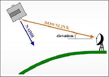
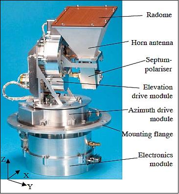
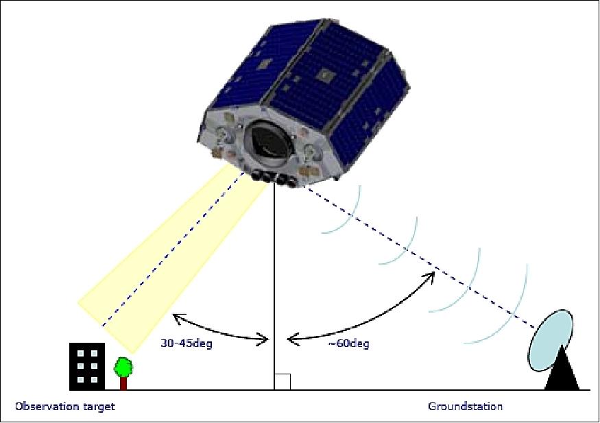
APM (Antenna Pointing Mechanism): A two-axis APM is providing a real-time imaging & downlinking capability in parallel for a range of targets close to the ground station. The APM incorporates a circularly polarized antenna with a narrow 3dB beam-width of 25º and on boresight gain of 15 dBi. It also houses the necessary drive electronics and structural elements to provide a nimble, 2-axis antenna solution that meets the stringent mission requirements. The pointing accuracy is better than 1º and the maximum slew rate is better than 20º/s, at acceleration rates up to 4º/s2. The APM focuses the RF energy into a high-gain spot-beam that can be mechanically steered in two axes to track the position of the ground station during passes even if the satellite performs high slew-rate maneuvers during a pass (Figure 13). 24) 25) 26) 27)
Articulation | 2-axis, ± 110º in elevation, ± 270º in azimuth |
Pointing | 0.024º steps, up to 19º/s rate, 0.72º accuracy |
Gain | 15 dBiC |
Beamwidth | 25º |
Polarization | LHCP or RHCP |
Power, mass, volume | 3.4 W, 2.7 kg, 240 mm x 196 mm x 185 mm |
The finished APM incorporates a very simple horn antenna that is circularly polarized and provides a gain of better than 15 dBiC on boresight with a 3 dB beamwidth of approximately 25º. The pointing accuracy is better than 1º and the maximum slew rate is better than 20º/s, at acceleration rates up to 4º/s2. The range of movement is ± 270º in azimuth and ± 114.7º in elevation. This capability is housed inside a compact body with static dimensions of 272 mm height and 196.2 mm maximum width, with an interface plate diameter of 185 mm. These dimensions also include the drive electronics which would typically sit below the mounting plane and therefore inside the satellite. The total mass, including drive electronics and antenna is 2.7 kg and the unit draws approximately 3.4 W with both axes moving.
NigeriaSat-2 actually has dual polarization capability with one APM antenna configured for left-hand polarization and the other APM antenna configured for right-hand polarization. SSTL typically employs cold redundancy for the payload downlink and a single PDC (Payload Downlink Chain) transmitting at 105 Mbit/s is enough to satisfy the baseline mission requirements for data throughput.
NigeriaSat-2 represents the first installation of the first generation APM technology demonstration. The APM is advantageous in reducing the DC power consumption of the power amplifier, and in turn requires smaller solar arrays. The mechanism is commanded to rotate upon receiving profile files from the MPS (Mission Planning System): which define the slew's duration, direction, rate and other parameters, whilst the APM self-monitors its actual position.
Pointing accuracy, pointing resolution | < 0.25º, ≤ 0.024º |
Slew range | Azimuth: ±270º, Elevation: ±110º |
Slew rate | ≤ 19.1º/s |
First model frequency | > 140 Hz |
Random vibration | 14.97 grms X/Y, 16.48 grms Z |
Radiation | TID at PCA is < 5 krad (Si) |
Design life | 7.5 years |
Life – number of cycles | 28,500 cycles (TVAC) + further 280,000 cycles (VAC only) = 308,500 cycles total |
Survival temperature | -50º to +70ºC mechanics, -30º to +70ºC electronics |
Operational temperature | -40º to +60ºC mechanics ,-20º to +50ºC electronics |
Total mass | 2.7 kg ±5% (including electronics and RF) |
Power | 3.36 W dynamic operation, 1.36 W static operation |
RF frequency | 8.0-8.5 GHz (X-band) |
RF antenna gain | 15 dBiC |
Insertion loss | ~1.2 dB at 6 W |
Telemetry interface | CAN bus |
Electrical interfaces | 50 Ω RF SMA connector. 15-way High-Density D-Type connector |
Data compression: The onboard imagery is compressed using lossless data compression for store-and-forward operations. Furthermore, switchable data encryption standard is available on the telemetry / telecommand, and switchable scrambling on payload data.
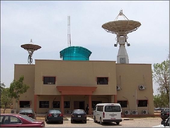
NigeriaSat-2 is designed to be operated from NASRDA's main ground station facility in Abuja, Nigeria.
It is worth noting that although the HSDR development was directed at NigeriaSat-2, this module actually gained already flight heritage on UK-DMC-2, which launched two years earlier. The unforeseen delay by the launch provider had a positive outcome, allowing SSTL to accumulate considerable operational flight heritage with the HSDR prior to its use on NigeriaSat-2 (Ref. 20).
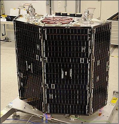
Both NigeriaSat-2 and NigeriaSat-X were completed in the middle of 2010, and the satellites were placed in storage prior to shipping out to the launch site. Both satellites were finally shipped in April 2011 to the Yasniy Cosmodrome via Moscow. The launch site operations included functional test and verification of the key satellite systems, propellant loading, and integration with the DNEPR launch upper stage. The NigeriaSat-X satellite was mounted on the lower section alongside several other co-passengers, and NigeriaSat-2 was mounted on the top-most platform by itself (Ref. 37).
Launch
NigeriaSat-2 was launched on August 17, 2011 on a Dnepr-1 launch vehicle using the SHM (Space Head Module) configuration from the Yasny/Dombarovsky launch site located in the Orenburg Region, Russia. 28)
In Sept. 2009, a contract was signed between ISC Kosmotras and SSTL for the launch of NigeriaSat-2 and NigeriaSat-X spacecraft. 29)
The primary payload of the cluster launch is the Sich-2 spacecraft of NSAU (National Space Agency of Ukraine) with a launch mass of 175 kg.
The secondary payloads on this flight are:
• N2 (NigeriaSat-2) of NASRDA, Abuja, Nigeria, spacecraft mass = 270 kg
• NX (NigeriaSat-X) of NASRDA, Abuja, Nigeria, spacecraft mass = 87 kg
• EduSat of the University of Rome (Sapienza), Italy, spacecraft mass = 10 kg
• RASAT of Tubitak Uzay, of Ankara, Turkey, spacecraft mass = 95 kg
• AprizeSat-5 and AprizeSat-6 of AprizeSat, Argentina built by SpaceQuest, Fairfax, VA, USA, each microsatellite features a next generation AIS (Automatic Identification System) payload. Each spacecraft has a mass of 14 kg. 30)
• BPA-2 (Blok Perspektivnoy Avioniki-2 — or Advanced Avionics Unit-2) of Hartron-Arkos, Ukraine. The BPA-2 experimental payload remained attached to the upper stage of the Dnepr-1 launch vehicle.
Deployment sequence: AprizeSat-5, AprizeSat-6, EduSat, NigeriaSat-X, RASAT, Sich-2, and NigeriaSat-2.
Orbit: Sun-synchronous circular orbit, initial altitude = 700 km x 733 km, inclination = 98.24º, the orbital period is about 99.5 min, the equatorial nodal crossing time is at 10:15 LTAN (Local Time on Ascending Node). Global revisit opportunities of at least every 2 days are possible (70% of the Earth's surface can be revisited in one day). - In due time, the orbit of NigeriaSat-2 will be made near-circular.
Mission Status
• According to a NASRDA paper presented at the SpaceOps conference in June 2016, the NigeriaSat-2 spacecraft and its payload are operating nominally in 2016 in their 5th year on orbit. 31)
• The NigeriaSat-2 spacecraft and its payload are operating nominally in 2015 in its 4th year on orbit (Ref. 32).
• The NigeriaSat-2 spacecraft and its payload are operating nominally in 2014. 32)
• August 2012: NigeriaSat-2 is operating nominally after one year of on-orbit life. So far, NigeriaSat-2 has demonstrated just how much performance can be achieved with a satellite of this class. The mission will enable NASRDA and Nigeria as a whole to reap more benefits from those gained from NigeriaSat-1. 33)
• NigeriaSat-2 is fully operational since May 2012. The official handover ceremony of NigeriaSat-2 between SSTL and NASRDA took place in July 2012. 34)
• NigeriaSat-2 makes its data also available to the DMC (Disaster Monitoring Constellation) consortium. The spacecraft is providing 100 to 400 scenes per day. 35)
• In May 2012, NASRDA disclosed that the testing of NigeriaSat-2 had been completed and that commercial activities would take off soon. 36)
- Along with the rest of the spacecraft systems, the X-band payload downlink chain has been fully commissioned and is now being used supporting nominal operations. The Eb/No levels received on the demodulator from NASRDA's 7.3 m X-band ground station in Abuja and SSTL's ground station in Guildford, UK, have been in line with that expected and a successful X-band downlink achieved from both chains (Ref. 20).
- In addition, two key functionalities have been demonstrated. Firstly, simultaneous imaging and downlink is being performed on a nominal basis. Secondly, simultaneous use of both downlink chains has been demonstrated, validating the concept of doubling data rate through polarization diversity. When operating both downlink chains simultaneously, a total sustained data rate of 210 Mbit/s has been achieved with no noticeable degradation in received Eb/No levels. Although NigeriaSat-2 will not be using this mode as standard, it is likely that future SSTL missions will take advantage of it as a means of increasing the total downlink capability (Ref. 20).
• Before final handover of SSTL to NASRDA in March 2012, propulsion firings were performed to circularize the orbit, followed by the final inertia calibration. Also prior to handover, some minor software modifications were made to the AOCS software and operating procedures to improve the robustness of the AOCS and improve the ease of operations. Finally, with the system in its operational state, a representative scenario involving image capture in all modes has been performed to contractually verify that the system meets its mission requirements. 37)
• As of late November 2011, NigeriaSat-2 was beginning the process of being handed over to the customer with the major AOCS calibration activities having been performed. Regular automated imaging sessions were being performed and the system was producing good quality images. The pointing and geolocation performance was shown to be well within pre-launch expectations and all modes of operation of the AOCS had been tested.
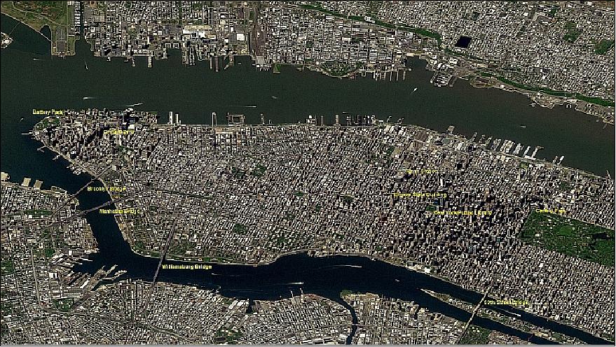
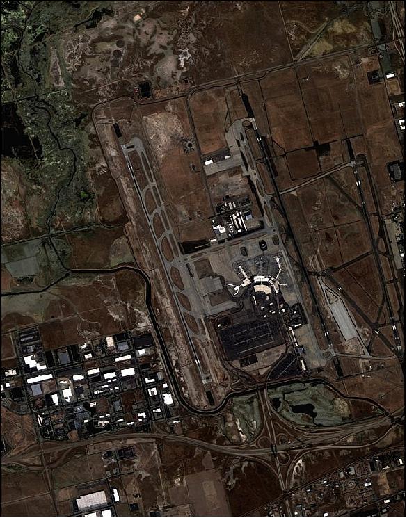
• In late September 2011, the operations team of NASRDA and SSTL continued the successful commissioning of the new satellite from NASRDA's headquarters in Abuja. Testing of all the systems on-board the satellite has been successfully completed, and calibration of the imaging payloads is ongoing with outstanding results already being produced. - On Sept. 28, 2011, NASRDA and SSTL released the first high-resolution imagery of NigeriaSat-2. 38)
- In early October 2011, commissioning is still ongoing, but this is to be expected given the capabilities of the NigeriaSat-2 spacecraft. 39)
• One notable unplanned event occurred three weeks after launch when SSTL Mission Control received a conjunction warning indicating a 26 m miss distance between NigeriaSat-2 and a piece of space debris. Operational plans were changed at 2 days notice to complete commissioning of the propulsion system (including a short test firing) and perform a collision avoidance maneuver. The rapid response to this, at an early stage of the mission, was in part due to the use of the same control mode for imaging and ΔV and therefore, no additional checkout of the AOCS was required beyond a slew to the firing attitude during the propulsion system test firing (Ref. 37).
• With the satellite in an Earth pointing attitude, the commissioning phase began. At this stage, the emphasis moved from AOCS related activities to performing a full check out of the platform in preparation for payload operations. The system is built up in a step-wise fashion with individual units being powered on for the first time and checked out as well as the upload of the OBC software required to operate the payload chain.
- For the AOCS, this meant operating the units that were used for the operational modes without running them in the loop. After performing the initial checkout of the star tracker and bridge, the nominal precise 3-axis mode was entered for the first time on Day 5. This mode was then available to support payload commissioning activities. A major driver for the system commissioning schedule was image acquisition for geometric and radiometric calibration of the imaging system. It was found that no tuning was required to the control system or the star trackers as there were no pointing performance issues that effected payload operations. The first image was captured by the spacecraft 8 days after launch (Ref. 37).
• Once NigeriaSat-2 was found to be in a healthy condition, the application software was loaded to the On-Board Computer during passes over both the Abuja and Guildford ground stations. The first task was to run the housekeeping task, which allows telemetry to be sampled and logged outside of ground station coverage. The first telemetry survey sampled magnetometer measurements around a full orbit, to allow the health of the magnetometers to be assessed and to gain a better estimate of the tumble rate of the satellite before starting to detumble. Following the upload of the housekeeping task, the AOCS software and drive file (containing configuration settings) was loaded (Ref. 37).
• Following confirmation of separation from the launch vehicle, ground stations in Guildford (UK) and Abuja (Nigeria) established contact with NigeriaSat-2 and NigeriaSat-X, respectively.
Two joint NASRDA-SSTL teams are working in parallel in Abuja and Guildford to commission NigeriaSat-X and NigeriaSat-2. After the initial commissioning phase is complete, the NASRDA team in Guildford will return to Nigeria to continue NigeriaSat-X operations from the Abuja ground station.
Sensor Complement
The spacecraft carries two pushbroom imagers offering simultaneous long-swath observations (up to 2000 km). A high duty imaging capability is provided with the high downlink data rate. 40)
The geolocation requirement of < 35 m without ground control points demands in turn that the thermo-elastic distortions between star cameras and the imager bore sight are kept to less than 0.001º. Additionally microvibration of the imager must be kept under control to achieve the required image quality. These issues are managed by mounting the VHRI, MRI payloads and the star cameras on a thermo-elastically stable optical bench which is supported on a compliant kinematic mount.
The compliant kinematic mount consists of a number of compliant links. The design of the compliant link is such that effectively it only constrains the optical bench in the axial direction of the link. Each link constrains 1 degree of freedom of the optical bench payload assembly. Thus with 6 correctly placed links the optical bench payload assembly would be fully constrained. The solution adopted uses 7 links which slightly over constrains the assembly.
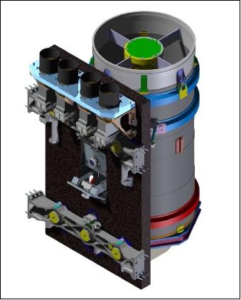
VHRI (Very High Resolution Imager)
The imager is providing 2.5 m panchromatic and 5 m four-band multispectral data (B, G, R, NIR) on a swath of 20 km. The panchromatic band has a spectral range of 450-900 nm. 41) 42) 43)
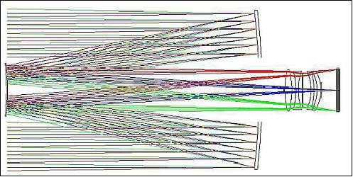
The Cassegrain-derived VHRI instrument design, built by SSTL, is of CMT (China Mapping Telescope) heritage flown on the Beijing-1 mission (also referred to as China DMC+4). SSTL has a philosophy of re-using existing designs wherever possible, to shorten development timescales and lower costs. Optical Surfaces Ltd. of Kenley (Surrey), UK was selected to built the Cassegrain camera.
The diameter of the primary mirror of VHRI is 385 mm, and the length of the telescope is ~ 1000 mm. VHRI is in fact a scaled up version of the CMT instrument (which has an aperture of 310 mm and a length around 800 mm).
The VHRI design is implemented in low expansion materials - carbon fiber composite for the structure, Zerodur and fused silica for the optics and low expansion alloys for optical mounts. The focal plane design is relatively simple, using long linear CCD arrays (e2v) and in-field separation of the color channels to avoid complex beam-splitting in the focal plane assemblies (Figures 18 & 19).
Focus control is implemented by moving one of the corrector lenses located near the centre of the primary mirror, to compensate for moisture release of the carbon fiber composite in orbit which, experience has shown, cannot be easily predicted. Isostatic mounting arrangements take up any differential expansion between the telescope and the satellite, simplifying satellite design and thermal control.
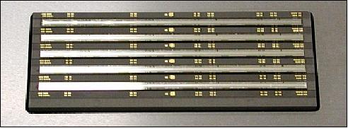
Band | Spectral range | Color |
1 | 450-520 nm | Blue |
2 | 520-600 nm | Green |
3 | 630-690 nm | Red |
4 | 760-900 nm | NIR (Near Infrared) |
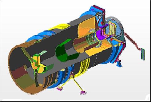
MRI (Medium Resolution Imager)
MRI is a 32 m medium-resolution multispectral imager providing data in 4 spectral bands with a swath width of 300 km. The instrument is an alternate version of SLIM6 (Surrey Linear Imager Multispectral 6 channels - but 3 spectral bands) imager flown on the 1st generation DMC missions - however with only half the original swath (configuration of 1 bank of imagers in 4 spectral bands).
Imaging Modes Supported: (Scene, Strip, Stereo, Area)
Based on its 700 km sun-synchronous orbit, a number of imaging modes are defined for the satellite. The standard modes are the scene and strip modes, and then more complex compound modes make use of the high agility to deliver stereo and area modes (Ref. 17).
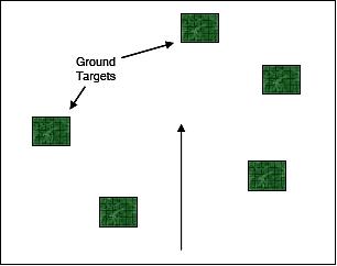
• Scene mode: The standard image product produced by the high-resolution imager is a 20 km x 20 km scene in all 5 available bands. The MRI (Medium Resolution Imager) product is an image 300 km across-track by 20 km along-track in the four spectral bands. When using the ‘scene' mode any location on the ground visible within the roll and pitch capability can be targeted and imaged with either or both of the imagers. Thanks to the high agility of the platform, images that are separated in the cross-track direction but not in the along-track direction can still be imaged. Figure 21 illustrates an example spread of images taken whilst in ‘Scene' mode.
The spacecraft has two maneuver modes: standard and fast response. The standard maneuver mode allows the spacecraft to set itself up for an image event slowly, thus consuming a small amount of power. In instances where image targets are closely located, the fast response maneuver uses a more powerful actuator to quickly achieve the required attitude.
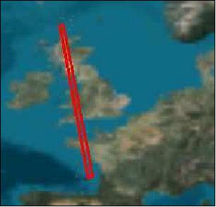
• Strip mode: To support applications such as mapping, individual scenes can be strung together to produce strip images covering long tracts of ground. As with the ‘Scene' mode, target locations anywhere in the wide field of regard can be imaged. Typically, strips would be set up using the standard maneuver mode, reserving the fast response mode for applications where a more responsive image is required.
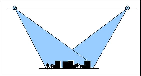
• Stereo mode: The compound modes focus on the use of the high-resolution imager. The first of these modes is the ‘Stereo' mode. This compromises a pair of images taken of the same location on the ground but from different view angles. This allows the two images to then be processed together to obtain height information about the target. Figure 23 gives an illustration of the way a stereo pair is created. The exact angle at which the two stereo images are taken can be varied depending on the application, and the available settling time between images varies accordingly.
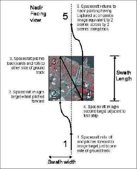
• Area mode: The most complex of the modes is the ‘Area' mode. This uses a combination of roll and pitch maneuvers to artificially widen the swath of the image for a limited period of time. By initially pitching forward and rolling to one side, the spacecraft can image a first strip of images. Following this, the spacecraft pitches back and rolls in the opposite direction to take a second strip, partially overlapping the first. Figure 24 shows the steps for a 2 x 2 area mode image.
N2 Ground Segment
NigeriaSat-2 will be operated by a team of trained NASRDA operations engineers from the recently upgraded ground station in Abuja.
As part of their latest training and development program, five NASRDA engineers undertook operations training, which will enable them to task, download and process image data, as well as manage day to day satellite operations.
For the LEOP (Launch and Early Operations) phase, four SSTL engineers will join the Nigeria operations team in Abuja. LEOP is expected to cover a period of around one week, during which time the satellite will be stabilized. Over the following few weeks, engineers will switch on and test each of the spacecraft modules, including the imaging system. This will be an exciting time when we'll see the first images and operations are handed over to the Nigerian team. 44)

A period of calibration will commence over 2-3 months before the Nigerian team begin downloading and processing targeted images, which will be used to help manage urban planning, deforestation, water and food resources and support emergency relief campaigns through the Disaster Monitoring Constellation. NigeriaSat-2 image data will also be made available commercially, supporting a sustainable space industry for Nigeria.
Data Policy: 45)
• Data access in Nigeria of N2 is free for research applications.
• The company GeoApps Plus Ltd. has been licensed by NASRDA to sell data within Africa.
• An exclusive agreement has been signed with DMCii to market data worldwide, except Africa.
NASRDA has an established RSO (Regional Support Office) within its campus location and provides functional support for all efforts of UN-SPIDER United Nations Platform for -Spaceborne Information for Disaster Management and Emergency Response) in the field of disaster management and Technical Advisory Mission.
The Nigerian regional perspective is integrated in the ALC (African Leadership Conference on Space Science and Technology for Sustainable Development) program, while the National Policy is central to providing Nigerians with data, and decision makers with information.
Dual use of Nigerian EO satellites: 46)
NASRDA is using its EO spacecraft for both security (military) and civilian services. Under the PATTEC (Pan African Tsetse and Trypanomosiasis Campaign), Nigeria launched its Tsetse and Trypanomosiasis eradication project in Nov. 2011, using its Earth observation satellite; likewise surveillance of both terrorist activities and of border monitoring are being undertaken using the Nigerian satellites.
Although the NigeriaSat-2 spacecraft was launched as a second generation DMC (Disaster Monitoring Constellation) satellite, its importance was immediately apparent in the area of health and security issues. Furthermore, Nigeria's collaboration with the spacecraft industry has led to its reaping benefits in technology transfer as well as contributing to disaster management as was evidenced in the use of the NigeriaSat-1 imagery to detect the extent of damages inflicted by hurricane Katrina. The satellite technology is also fostering better relationship with other African countries and has led to the ARMC (African Resource Management Constellation) ; the PATTEC program is benefitting from ARMC.
Note: The PATTEC initiative was created following a decision by the African Heads of State and Government at the AU Summit in Lomé, Togo in July 2000. The reason for creating PATTEC was that individual countries failed in their efforts in controlling the spread of tsetse flies and the realization that only a synergistic approach by African countries can solve the problems of tsetse and Trypanomosiasis.
Nigeria is a member of UN COPUOS (Committee on the Peaceful Uses of Outer Space) and as a nation has been involved in various peacekeeping missions on the African continent. Earth Observation satellites are being employed worldwide in monitoring terrorism. The role of the NigeriaSat-2 spacecraft for geospatial data gathering for a country as large as Nigeria, with over 200 ethnic groups and 774 local government areas cannot be over emphasized. The need to collect and analyze geospatial data and intelligence data has never been more important.
The imaging data of the NigeriaSat-2 is being used in the following areas of national security:
- DTM (Digital Terrain Model)
- High accuracy mapping, location identification and urban intelligence
- Pipeline and illegal oil bunkering monitoring
- Border security and control
- Infrastructure mapping
- Training of military personnel.
Ground Stations
In 2012, Nigeria has two ground receiving stations, one is located at NCRS (National Center for Remote Sensing)), Jos,located on the Jos Plateau ; the other site is at CSTD (Center for Satellite Technology and Development), Abuja, Nigeria.
The NCRS was established under NASRDA, and charged with the responsibility of harmonizing research and development in space science and technology application for sustainable socio-economic development. NCRS, therefore, acquires, process, archive and distribute satellite data from NigeriaSat-1, NigeriaSat-2 and NigeriaSat-X. In order to efficiently do this, NCRS has established Space Application Laboratories in three of the six geopolitical zones of the country: Ile-Ife (South-West), Uyo (South-South), and Kano (North-West). 47)
The Earth observation satellites of Nigeria collect raw data and send it to the Ground Receiving Stations. These data, in their primary state, are then processed. The radiometric and geometric distortions are first rectified and archived in digital form in accordance with the National image acquisition index. The acquired data are in most cases distributed to the laboratories where they are processed using appropriate computerized programs.
The NCRS station in Jos is positioned to receive and archive real time satellite data. Apart from receiving from the Nigerian Earth observation satellites, the Center receives and archives data from the NOAA AVHRR radiometer on a daily basis. In March 2010, the installation of the MODIS (Moderate-Resolution Imaging Spectroradiometer) acquisition equipment (direct broadcast data in Ku-band and S-band) at the NCRS station was completed. Since this time, NCRS Jos is capable of receiving real-time MODIS data from the Terra and Aqua satellites of NASA. In total,the MODIS acquisition equipment is used in support of the following six satellites on a daily basis: Terra, Aqua, MetOp-A, FY (Feng Yun), NOAA-18 and NOAA-19.
The imagery of NigeriaSat-2 and NigeriaSat-X missions cannot be received at NCRS since an X-band reception capability is currently not available at the NCRS station. Only the CSTD (Center for Satellite Technology and Development) in Abuja is equipped for X-band reception.
References
1) "SSTL Signs Contract With Federal Republic Of Nigeria For Supply of Earth observation Satellite," Nov. 6, 2006, URL: https://web.archive.org/web/20120722035535/http://www.technologynewsroom.com/press_releases/company_releases.aspx?story=617
2) M. Sweeting, A. da Silva Curiel, D. Purll, M. Cutter, W. Sun, "Small Satellites for Operational Earth Observation," Proceedings of the Asian Space Conference 2007, Nanyang Technological University (NTU), Singapore, March 21-23, 2007
3) M. A. Cutter, D. Hodgson, P. E. Davies, A. Baker, K. Graham, S. Mackin, M. Vanotti, M. N. Sweeting, "Utilization of DMC Experience and the potential usage of DMC Services to provide additional support to a European global monitoring system program," Proceedings of the 21st Annual AIAA/USU Conference on Small Satellites, Logan, UT, USA, Aug. 13-16, 2007, SSC07-II-11
4) M. Cutter, A. Baker, A. Cawthorne, P. Davies, M. Sweeting, "A High Performance EO Small Satellite Platform," 58th IAC (International Astronautical Congress), International Space Expo, Hyderabad, India, Sept. 24-28, 2007, IAC-07-B1.I.10
5) A. Cawthorne, M. Beard, A. Carrel, G. Richardson, Abdul Lawal, "Launching 2009: The NigeriaSat-2 mission - High-performance Earth observation with a small satellite," Proceedings of the 22nd Annual AIAA/USU Conference on Small Satellites, Logan, UT, USA, Aug. 11-14, 2008, SSC08-III-7
6) Andrew Cawthorne, Andrew Carrel, Martin Sweeting, Abdul Lawal, "NigeriaSat-2 – The high-performance small satellite programme at the service of Nigeria," Proceedings of the 59th IAC (International Astronautical Congress), Glasgow, Scotland, UK, Sept. 29 to Oct. 3, 2008, IAC-08-B4.1.5
7) R. A. Boroffice, "The Nigerian Space Programme: An Update," African Skies/Cieux Africains, No 12, Oct. 2008, URL: http://www.saao.ac.za/~wgssa/archive/as12/boroffice.pdf
8) Keith Clark, Kevin Maynard, "'I Can see you!' - How Satellite Imagery dictates the Need for Speed," URL: http://www.armms.org/images/conference/1-i_can_see_you-sstl.pdf
9) Ganiy I. Agbaje, "Nigeria in Space – an Impetus for Rapid Mapping of the Country for Sustainable Development Planning," Proceedings of the FIG (International Federation of Surveyors) Congress 2010, Sydney, Australia, 11‐16 April 2010, URL: http://www.fig.net/pub/fig2010/ppt/ts03h/ts03h_agbaje_ppt_4621.pdf
10) Martin Sweeting, "Microsatellites: moving from research to constellations meeting real operational missions," Tokyo, June 9-11, 2010, URL: http://unisec.jp/nanosat_symposium/1st/files/11th.PM/Session_5/Presentation_Martin-Sweeting.pdf
11) Olufemi A. Agboola, "Space System and Engineering in Africa: Nigeria as a Case Study," The 4th African Leadership Conference on Space Science and Technology for Sustainable Development-ALC 2011, Mombasa, Kenya, Sept. 26-28, 2011, URL: http://www.oosa.unvienna.org/pdf/bst/ALC2010/10_NIGERIA-ALC-2011-ESS-V1_.pdf
12) M. Cutter, P. Davies, A. Baker, M. Sweeting, "A High Performance EO Small Satellite Platform (SSTL-300)," Proceedings of the 3rd International Conference on RAST (Recent Advances in Space Technologies), Istanbul, Turkey, June 14-16, 2007, URL: http://epubs.surrey.ac.uk/2001/1/fulltext.pdf
13) Ganiy I. Agbaje, "Nigerian National Geospatial Data Infrastructure Programme," UNSDI (United Nations Spatial Data Infrastructure) Global Partners Meeting, ESA/ESRIN, Frascati, Italy, March 1-2, 2007
14) Alex da Silva Curiel, A. Haslehurst, P. Garner, M. Pointer, A. Cawthorne, "Increasing the Data Volume returned from Small Satellites," Proceedings of the 7th IAA Symposium on Small Satellites for Earth Observation, Berlin, Germany, May 4-7, 2009, IAA-B7-0901
15) Andrew R. Carrel, Andrew D. Cawthorne, Guy Richardson, Luis M. Gomes,"How do we do the same as the Big Boys? Enabling Systems and Technologies for Advanced Small Satellite Engineering," Proceedings of the 24th Annual AIAA/USU Conference on Small Satellites, Logan, UT, USA, Aug. 9-12, 2010, SSC10-VII-5
16) Andrew Cawthorne, Andrew Carrel, Joost Elstak, Luis Gomes, Guy Richardson, "Not just Big Customers with Big Bucks: how to get sub-meter imagery from a small satellite," Proceedings of the 61st IAC (International Astronautical Congress), Prague, Czech Republic, Sept. 27-Oct. 1, 2010, IAC-10-B1.2.11
17) Andrew Cawthorne, Andrew Carrel, Alex da Silva Curiel, Philip Davies, Martin Sweeting, "Development of a High Agility Small Satellite Mission," Proceedings of the 61st IAC (International Astronautical Congress), Prague, Czech Republic, Sept. 27-Oct. 1, 2010, IAC-10.B4.2.7
18) Andrew Carrel, Paul Alderton, "MEMS in Space – A New Technology Advancing from Flight Experiment to Proven COTS Product," Proceedings of the 23nd Annual AIAA/USU Conference on Small Satellites, Logan, UT, USA, Aug. 10-13, 2009, SSC09-XI-11
19) F. D. Chizea, J. I. Ejimanya, "NigeriaSat-2: Technical Parameters, Operational Perspectives and Target Applications," URL: http://www.nasrda.net/Earth_Future/NigeriaSat_2_Paper3.doc
20) Mark Brenchley, Peter Garner, Andrew Cawthorne, Katarzyna Wisniewska, Philip Davies, "Bridging the Abyss - Agile data downlink solutions for the Disaster Monitoring Constellation," Proceedings of the 4S (Small Satellites Systems and Services) Symposium, Portoroz, Slovenia, June 4-8, 2012
21) Peter Garner, David Cooke, Andrew Haslehurst, "Development of a Scalable Payload Downlink Chain for Highly Agile Earth Observation Missions in Low Earth Orbit," Proceedings of the 4th International Conference on Recent Advances in Space Technologies (RAST 2009), Istanbul, Turkey, June 11-13, 2009
22) A. da Silva Curiel , A. Haslehurst, P. Garner, M. Pointer, A. Cawthorne, "Increasing the Data Volume Returned from Small Satellites," Proceedings of the 7th IAA Symposium on Small Satellites for Earth Observation, Berlin, Germany, May 4-7, 2009, IAA-B7-0901
23) A. da Silva Curiel, A. Haslehurst, P. Garner, M. Pointer, "Increasing the Data Volume Returned from Small Satellites," Proceedings of the 27th ISTS (International Symposium on Space Technology and Science) , Tsukuba, Japan, July 5-12, 2009, paper: 2009-n-20
24) Peter Garner, Nigel Phillips, Andrew Cawthorne, Alex da Silva Curiel, Phil Davies, Lee Boland, "Follow that Ground Station! And double the data throughput using polarization diversity," Proceedings of the 23nd Annual AIAA/USU Conference on Small Satellites, Logan, UT, USA, Aug. 10-13, 2009, SSC09-V-5
25) Mark Brenchley, Peter Garner, Kevin Maynard, Tim Butlin, Eckhard Krabel, "Supporting Omni-Directional Communications Capability In Variable Attitude Spacecraft," Proceeding of the 4th Microwave & Radar Week, MRW-2010, Vilnius, Lithuania, June 14-18, 2010
26) Mark Ferris, Nigel Phillips, "The Use and Advancement of an Affordable, Adaptable Antenna Pointing Mechanism," Proceedings of the 14th European Space Mechanisms & Tribology Symposium – ESMATS 2011, Constance, Germany, Sept. 28–30 2011 (ESA SP-698), URL: http://www.esmats.eu/esmatspapers/pastpapers/pdfs/2011/ferris.pdf
27) "Antenna Pointing Mechanism (APM) & High Gain X-Band Antenna," URL: http://www.sstl.co.uk/Downloads/Datasheets/Subsys-datasheets/Antenna-Pointing-Mechanism-ST0118003-v002-00
28) "Successful launch of Dnepr launch vehicle performed on 17 August 2011," ISC Kosmotras, August 17, 2011, URL: https://web.archive.org/web/20111030095234/http://www.kosmotras.ru/en/news/110/
29) "Highly advanced NigeriaSat-2 small satellite launch date announced," SSTL, May 11, 2010, URL: https://web.archive.org/web/20100717173216/http://www.sstl.co.uk:80/News_and_Events/Latest_News/?story=1569
30) "Dnepr launches AprizeSat-5 and AprizeSat-6," SpaceQuest, August 17, 2011, URL: http://www.spacequest.com/Articles/AprizeSat_Launch_8-17-11.pdf
31) Ikpaya O. Ikpaya, Spencer O. Onuh, Christopher U. Achem, Fidelis Y. Madalla, "Quest of Nigeria into Space for Sustainable Development," Proceedings of the 14th International Conference on Space Operations (SpaceOps 2016), Daejeon, Korea, May 16-20, 2016, paper: AIAA 2016-2345, URL: http://arc.aiaa.org/doi/pdf/10.2514/6.2016-2345
32) Information provided by Audrey Nice of SSTL and by Dave Hodgson of DMCii, Guildford, UK
33) Alex da Silva Curiel, Andrew Carrel, Andrew Cawthorne, Luis Gomes, Martin Sweeting, Francis Chizea, "Commissioning of NigeriaSat-2 High Resolution Imaging Mission," Proceedings of the 26th Annual AIAA/USU Conference on Small Satellites, Logan, Utah, USA, August 13-16, 2012, paper: SSC12-XI-6, URL: http://digitalcommons.usu.edu/cgi/viewcontent.cgi?article=1092&context=smallsat
34) "Nigeria receives two Earth Observation Satellites," July 10, 2012, URL: http://www.channelstv.com/home/2012/07/10/nigeria-receives-two-earth-observation-satellites/
35) J. Paul Stephens, "New sensors; Update on developments in the DMC Constellation," Proceedings of the 11th Annual JACIE (Joint Agency Commercial Imagery Evaluation ) Workshop, Fairfax, Va, USA, April 17-19, 2012, URL: http://calval.cr.usgs.gov/wordpress/wp-content/uploads/Stephens_JACIE_DMCii_presentationApr2012.pdf
36) "Nigeria to commercialize satellite services: official," Space Daily, May 14, 2012, URL: http://www.spacedaily.com/reports/Nigeria_to_commercialize_satellite_services_official_999.html
37) Alex da Silva Curiel, Andrew Carrel, Andrew Cawthorne, Luis Gomes, Martin Sweeting, Francis Chizea,"Commissioning of the NigeriaSat-2 high resolution imaging mission," Proceedings of the 4S (Small Satellites Systems and Services) Symposium, Portoroz, Slovenia, June 4-8, 2012
38) "Nigeria's new satellite demonstrates stunning high resolution capability," SSTL, Sept. 28, 2011, URL: https://spaceref.com/press-release/nigerias-new-satellite-demonstrates-stunning-high-resolution-capability/
39) Robin Wolstenholme, "NigeriaSat-2 and NigeriaSat-X orbiting Earth," SSTL, Oct. 12, 2011, URL: http://blog.sstl.co.uk/archives/387-NigeriaSat-2-and-NigeriaSat-X-orbiting-Earth.html
40) M. Cutter, P. Davies, A. Baker, M. Sweeting, "A High Performance EO Small Satellite Platform & Optical Sensor Suite," Proceedings of IGARSS 2007 (International Geoscience and Remote Sensing Symposium), Barcelona, Spain, July 23-27, 2007
41) Adam M. Baker, Mike Cutter, Andrew Cawthorne, Alex da Silva Curiel, "Reading the Fine print from Orbit: Its not just about the resolution," Proceedings of the 22nd Annual AIAA/USU Conference on Small Satellites, Logan, UT, USA, Aug. 11-14, 2008, SSC08-IV-5
42) Andrew Cawthorne, David Purll, Stuart Eves, "Very High Resolution Imaging Using Small Satellites," 6th Responsive Space Conference, Los Angeles, CA, USA April 28 - May 1, 2008, AIAA-RS6-2008-4007, URL: https://web.archive.org/web/20130319104956/http://www.responsivespace.com/Papers/RS6/SESSIONS/SESSION%20III/4007_CAWTHORNE/4007P.pdf, URL of presentation: https://web.archive.org/web/20120824051336/http://www.responsivespace.com/Papers/RS6/SESSIONS/SESSION%20III/4007_CAWTHORNE/4007C.pdf
43) Andrew Cawthorne, "Very High Resolution Imaging Using Small Satellites," 6th Responsive Space Conference, Los Angeles, CA, USA April 28 - May 1, 2008 URL: https://web.archive.org/web/20120824051336/http://www.responsivespace.com/Papers/RS6/SESSIONS/SESSION%20III/4007_CAWTHORNE/4007C.pdf
44) "The road to commissioning NigeriaSat-2 in Abuja," SSTL, August 15, 2011, URL: http://blog.sstl.co.uk/archives/381-The-road-to-commissioning-NigeriaSat-2-in-Abuja.html
45) Halilu Ahmad Shaba, "Nigerian Space Program and African regional perspectives," Proceedings of the 49 Session of UN COPUOS (Committee on the Peaceful Uses of Outer Space), STSC (Scientific and Technological Subcommittee), Vienna, Austria, Feb. 6-17, 2012, URL: http://www.oosa.unvienna.org/pdf/pres/stsc2012/2012ind-03E.pdf
46) Olojo. O. Olabamiji, Toyin .O. Osazuwa, Stephen A. Adegoke, Mabel U. Ogar, "The dual role of Nigerias Earth observation satellites as it relates to health and national security," Proceedings of the 63rd IAC (International Astronautical Congress), Naples, Italy, Oct. 1-5, 2012, paper: IAC-12.B1.6.6
47) John Olusoji Nester, Eguaroje Ezekiel, S. O. Mohammed, Irepagamoye Joyce Adejube, "Remotely-Sensed Data Management System in Nigeria: the Role of National Centre for Remote Sensing, Jos." Proceedings of the 63rd IAC (International Astronautical Congress), Naples, Italy, Oct. 1-5, 2012, paper: IAC-12-B1.4.11
The information compiled and edited in this article was provided by Herbert J. Kramer from his documentation of: "Observation of the Earth and Its Environment: Survey of Missions and Sensors" (Springer Verlag) as well as many other sources after the publication of the 4th edition in 2002. - Comments and corrections to this article are always welcome for further updates (eoportal@symbios.space).
Overview Spacecraft Launch Mission Status Sensor Complement Ground Segment References Back to top