Monitor-E (Monitor Experimental)
EO
ROSKOSMOS
Mission complete
Imaging multi-spectral radiometers (vis/IR)
Quick facts
Overview
| Mission type | EO |
| Agency | ROSKOSMOS |
| Mission status | Mission complete |
| Launch date | 26 Aug 2005 |
| End of life date | 21 Jan 2008 |
| Measurement domain | Land |
| Measurement category | Multi-purpose imagery (land), Albedo and reflectance, Landscape topography |
| Measurement detailed | Land surface imagery, Earth surface albedo, Land surface topography |
| Instruments | RDSA, PSA |
| Instrument type | Imaging multi-spectral radiometers (vis/IR) |
| CEOS EO Handbook | See Monitor-E (Monitor Experimental) summary |
Monitor-E (Monitor Experimental)
Monitor-E is a Russian Earth observation mission of KhSC (Khrunichev Space Center) on a small-class generic satellite series. The spacecraft was designed and developed by KhSC of Moscow, Russia. 1) 2)
The Monitor-E mission represents the first operational use of the newly developed modular and multipurpose Yakhta platform, intended for use in various remote sensing, communications, and space research applications.
Spacecraft
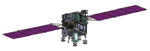
The spacecraft is 3-axis stabilized using the generic Yakhta platform with a launch mass of 720 kg. The attitude pointing accuracy is 0.1º, the attitude rate control accuracy is 0.001º/s (angular drift). Power of 1400 W (max at EOL) is provided by two solar panels. The spacecraft features a cross-track pointing capability of ±30º from nadir by using a flywheel system, thereby providing a FOR (Field of Regard) for observation coverage considerably beyond that of the nominal swath width. This new S/C agility is provided by the introduction of a CMG (Control Moment Gyro) subsystem, an actuator within the ADCS (Attitude Determination and Control Subsystem), developed by Russian industry. KhSC refers to the ADCS as ICS (Integrated Control System). The S/C system design life is 5 years.
Note: The Monitor-E spacecraft is of Monitor-E heritage (same name of previous and current missions) which was launched on June 30, 2003 from Plesetsk on a Rockot KS vehicle. On this flight, Monitor-E functioned as a mock-up (or prototype) spacecraft of KhSC with a mass of 700 kg. The spacecraft Monitor-E remained attached to the upper stage of the launch vehicle, it was used for demonstration purposes.
RF communications
The payload data are being received in X-band by ground stations of federal, regional, and local levels in Russia. An effort is being made to acquire the data in near real-time in support of fast reaction response applications.
Orbit: Sun-synchronous near-circular orbit: mean altitude = 540 km, inclination = 97.5º.
Launch
A launch of Monitor-E took place on Aug. 26, 2005 on a Rockot Breeze-KM launch vehicle of Eurockot Launch Services from the Plesetsk Cosmodrome, Russia.
Mission Status
• In August 2008, Monitor-E was removed from service (Ref. 1).
• In Feb. 2007, the Monitor-E spacecraft experienced another malfunction of the ADCS. This anomaly required an extensive investigation of the problem. As of July 2008, the project is still updating the software of the ADCS. During the checkout phase, observations are being realized only periodically. 3)
Up to Feb. 2007, Monitor-E was operational. So far, the spacecraft has collected imagery of more than 80 million km2 (Ref. 3).
• After launch and orbit insertion, the spacecraft experienced initial attitude control problems (flight controllers lost contact with the satellite). However, the flight controllers have regained control of Monitor-E, all systems are operating nominally and the spacecraft is in the commissioning phase as of early November 2005 (the checkout phase is estimated to last for up to 6 months to test the new components of the platform and the payload - and to conduct various operational experiments).
• In Sept. 2006, Monitor-E experienced a malfunction of its ADCS (Attitude Determination and Control Subsystem). After analysis of the problem nature, a software work-around procedure was developed and successfully installed onboard...
Sensor Complement
PSA, RDSA
The spacecraft payload consists of two optoelectronic pushbroom imagers designed and developed for the Khrunichev Space Center by the subcontractor S. A. Zverev Mechanical Plant of Krasnogorsk, Russia. The total payload mass is 270 kg and the power consumption is 450 W. The objectives are to use the panchromatic and multispectral imagery for a wide spectrum of applications such as in agriculture, forestry, environmental monitoring, geological mapping and prospecting of natural resources, and risk management. 4)
PSA, a panchromatic (Pan) imager for Earth surface monitoring. The instrument is also referred to as Gamma-L.
RDSA, a multispectral (MS) imager for Earth surface monitoring. The instrument is also referred to as Gamma-C.
Both instruments can be operated simultaneously. The instrument operation offers ground surface imagery in the following modes:
1) Along-track imaging (default mode) - where the imagers observe the ground in nadir-pointing fashion
2) Stripmap imaging for target-oriented observations - in this case the spacecraft uses its a body-pointing capability in the cross-track direction (±30º) to increase its FOR (Field of Regard). The intent is to cover targets of user requests or special events in the nearby ground-track vicinity.
3) In another mode, the agile S/C is able to offer stereo imagery by pointing quickly in the along-track direction in the range of ±30º.
Parameter | PSA (Pan Imager) | RDSA (MS Imager) |
Spectral band (s) | 0.536-0.843 µm | 0.528-0.585 µm |
Spatial resolution | 8 m | 20 m (40 m) |
Swath width | 96 km | 160 km |
FOR (Field of Regard) in cross-track | 780 km | 890 km |
Data transmission rate | 15.36 or 61.44 or 122.88 Mbit/s | |
The final data products are images with standard radiometric and geometric corrections, geocoded images in geographic projection, ortho-rectified images, mosaics, and digital maps. Maps of scale 1:50,000 may be generated.
References
1) http://eng.ntsomz.ru/spacecraft/monitor_e/
2) Information provided by Inessa Glazkova of the Khrunichev Space Center, Moscow
3) Information provided by Inessa Glazkova of the Khrunichev Space Center, Moscow
4) V. V. Asmus, V. N. Dyaduchenko, O. E. Milekhin, A. B. Uspensky, “Remote Sensing Products and Applications: Roshydromet Program,” EUMETSAT Meteorological Satellite Conference, Dubrovnik, Croatia, Sept. 19-23, 2005
The information compiled and edited in this article was provided by Herbert J. Kramer from his documentation of: ”Observation of the Earth and Its Environment: Survey of Missions and Sensors” (Springer Verlag) as well as many other sources after the publication of the 4th edition in 2002. - Comments and corrections to this article are always welcome for further updates (eoportal@symbios.space).