JERS-1 (Japan Earth Resources Satellite)
EO
JAXA
Mission complete
High resolution optical imagers
JERS-1 generated data on geological phenomena, agriculture and forestry land usage, coastal regions and environment and disaster management. The mission, launched in February 1992, had a nominal design life of two years. It was eventually extended by three additional years, ending in October 1998.
Quick facts
Overview
| Mission type | EO |
| Agency | JAXA, NASDA |
| Mission status | Mission complete |
| Launch date | 11 Feb 1992 |
| End of life date | 12 Oct 1998 |
| Measurement domain | Land, Snow & Ice |
| Measurement category | Multi-purpose imagery (land), Vegetation, Albedo and reflectance, Landscape topography, Sea ice cover, edge and thickness, Snow cover, edge and depth |
| Measurement detailed | Land surface imagery, Vegetation type, Fire fractional cover, Earth surface albedo, Land cover, Land surface topography, Sea-ice cover, Snow cover, Normalized Differential Vegetation Index (NDVI), Iceberg fractional cover, Iceberg height, Glacier motion, Above Ground Biomass (AGB), Snow melting status (wet/dry) |
| Instruments | L-band SAR, OPS, JERS-1 Comms |
| Instrument type | High resolution optical imagers, Communications, Imaging microwave radars |
| CEOS EO Handbook | See JERS-1 (Japan Earth Resources Satellite) summary |
Related Resources

Summary
Mission Capabilities
Three instruments were carried onboard JERS, namely:
- L-band SAR,
- OPS
- JERS-1 Comms.
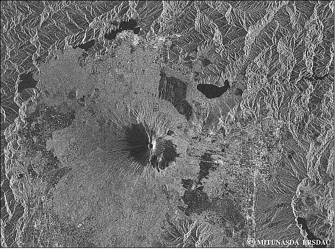
L-band Synthetic Aperture Radar (L-band SAR) was a microwave radar used for imaging land and ice, used in Earth resource management and interferometry.
OPS (Optical Sensor) was a high-resolution multi-spectral imager for land applications. The purpose of SAR and OPS was to generate global data sets to survey resources and establish an integrated Earth observation system.
JERS-1 Comms was the communications package for JERS-1.
Performance Specifications
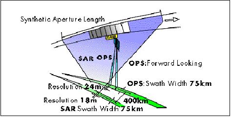
The waveband for measurement was microwave L-Band (1275 MHz). As for OPS, it possessed a swath width of 75 km and a resolution of 18.3 metres x 24.2 metres.
It had three measurement wavebands:
- 0.4 - 0.75 µm for visible light (VIS),
- 0.76 - 0.89 for Near InfraRed (NIR) light,
- 1.3 - 3 µm for Short Wave InfraRed (SWIR).
JERS Comms also communicated at a Medium Wave length waveband (0.1 to 100 cm).
JERS-1 operated in a sun-synchronous orbit with an inclination of 97.7° and an altitude of 568 kilometres. SAR had a swath width of 75 km with a surface resolution of 18 metres.
Space and Hardware Components
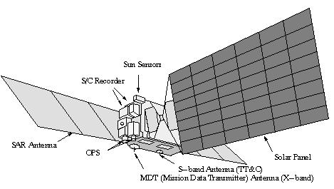
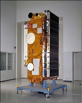
JERS-1 was built by Mitsubishi Electric, consisting of a rectangular bus 0.9 m x 1.8 m x 3.2 m, with a single 2 kW solar array. The satellite also contained an eight-segmented SAR antenna, weighing a total of 1400 kilograms.
In August 1997, the satellite lost the capability to record data and limited coverage areas only to JERS-1 ground station areas. In October 1998, an error, which was assumed to be an altitude control system failure, caused the satellite to terminate. JERS-1 re-entered the atmosphere in December 2001.
The main ground station was the NASDA Earth Observation Centre (EOC), complemented by several licensed foreign receiving stations.
JERS-1 (Japan Earth Resources Satellite) / Fuyo-1
JERS-1 (nickname of Fuyo-1) is a joint NASDA/MITI/STA [National Space Development Agency (Japan)/Ministry of International Trade and Industry (Japan)/Science and Technology Agency (Japan)] radar satellite project (NASDA/STA developed the satellite (built by Mitsubishi Electric Co.); MITI sponsored the instruments).
The overall objectives call for:
- Generation of global data sets with SAR and OPS sensors in order to survey resources;
- Establishing an integrated Earth observation system, verifying instrument/system performances.
The mission applications focus on:
- survey of geological phenomena,
- land usage (agriculture, forestry),
- observation of coastal regions,
- geologic maps,
- environment,
- disaster monitoring, etc.
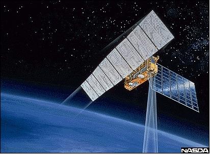
The spacecraft carries two closely matched Earth observation sensors:
- the active SAR instrument
- the passive OPS multispectral imager. 1)
Note: JAXA is the new name (merger) of the three former Japanese space organizations into a single national agency, namely: NASDA (National Space Development Agency of Japan), ISAS (Institute of Space and Astronautical Science), and NAL (National Aerospace Laboratory of Japan). The merger took place on Oct. 1, 2003.
Spacecraft
The JERS-1 spacecraft, built by Mitsubishi Electric Co. as the prime contractor, consists of a net rectangular bus (0.9 m x 1.8 m x 3.2 m) with a single 2 kW solar array (3.5 m x 7.0 m) and an eight-segmented SAR antenna. The spacecraft is three-axis stabilized with a zero momentum bias system using reaction wheels and magnetotorquers. The attitude is sensed by an Earth sensor, an inertial reference unit and two sun sensors (0.3º attitude knowledge). A hydrazine propulsion system is used for orbit maintenance.
Nominal mission design life = 2 years.
Satellite mass = 1400 kg at launch. 2) 3) 4) 5)
Launch
The JERS-1 satellite was launched on Feb. 11, 1992, from Tanegashima Space Center by a two-stage H-I launch vehicle of NASDA.
Orbit: Sun-synchronous subrecurrent polar orbit; inclination = 97.7º; repeat cycle = 44 days (westward); altitude = 568 km; period = 96 minutes, local mean time = 10:30 - 11:00 AM on descending node.
RF communications: The spacecraft employs MDR (Mission Data Recorder) permitting a recording time of up to 20 minutes of SAR and OPS data (data capacity of 7.2 x 10⁴ Mbit). JERS-1 transmits its payload data in two X-band frequencies: F1 and F2. F1 operates in the 8025-8175 MHz range and F2 in the 8215-8400 MHz range. The S/C EIRP is 32 dBm (nadir) and 47 dBm (66º from nadir). The links employ QPSK (Quadra-Phase Shift Keying) modulation at a data rate of 60 Mbit/s (right-hand circular polarized antenna onboard the S/C).
Mission Status
• The JERS-1 spacecraft reentered around 67º south latitude and 20º west longitude over the south Antarctic offshore Antarctica on December 3, 2001 (information released by NASA).
• On Oct. 11, 1998, a malfunction occurred on JERS-1 (very probably an attitude control system failure) causing the termination of satellite operations. Hence, a total of about 6 1/2 years of observation time could be achieved with JERS-1 (with a design life of 2 years). - Already in August 1997, the JERS-1 spacecraft had lost the ability to record data, therefore limiting its coverage to areas within JERS-1 ground station masks.
Sensor Complement
SAR (Synthetic Aperture Radar)
Measurement in L-band (1.275 GHz) in HH polarization. The instrument consists of the following subsystems: antenna, transmitter/receiver, and signal processor. The SAR antenna is composed of eight 2.2 m x 1.5 m panels, measuring 2.2 m x 11.9 m in total. A honeycomb sandwich structure is used. The signal processor performs several functions. First, it performs the A/D conversion of I and Q video signals from the transmitter/receiver. Secondly, after formatting the A/D converted I and Q data plus other data necessary for processing on the ground, it transmits the I and Q channel data. Finally, it controls itself and the transmitter/receiver based on commands received from the ground stations. The range of incidence angles within a typical image is fixed between 32º at the near range and 38º at the far range. SAR transmits 1,500 pulses/s from the antenna with a mean off-nadir angle of 35º to the right side of the satellite. - The L-band SAR of JERS-1 demonstrated also two-pass SAR interferometry for change detection. 7) 8) 9)
Calibration: SAR onboard calibration is for receiver gain. The parameter derived from the SAR image mode is the normalized radar backscattering coefficient, sigma-zero. The absolute accuracy of the image product is dependent upon the calibration efforts undertaken at each processing facility. 10) 11)
Centre frequency | 1.275 GHz (L-band, 23.5 cm wavelength) |
Bandwidth | 15 MHz |
Spatial resolution | 18 m (range) x 18 m (azimuth, 3 looks) |
Swath width | 75 km |
Transmitting power | 1100-1500 W |
Pulse width | 35 µs |
PRF (Pulse Repetition Frequency) | 1505.8 - 1606.0 Hz |
Antenna | Array of 1024 microstrip radiation elements |
Data quantization | 3 bits |
Data rate | 60 Mbit/s |
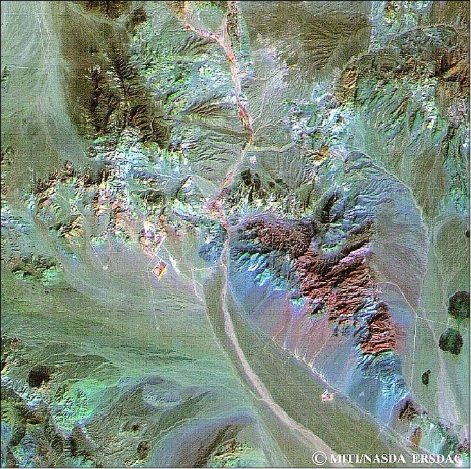
OPS (Optical Sensor)
OPS is a high-resolution radiometer (a passive instrument) with the objective to measure sunlight reflected by the Earth's atmosphere in eight bands (colour imagery).
OPS consists actually of two independent radiometers:
- the VNIR band instrument
- the SWIR radiometer.
Swath width = 75 km, spatial resolution = 18.3 m (cross-track direction) x 24.2 m (along-track direction).
Band 4 is for off-nadir viewing (15.33 forward in flight direction); bands 3 and 4 make a stereo pair (an effective two-line stereoscopic along-track imaging capability). The stereo images are useful for geomorphology and digital elevation model (DEM) construction.
Data from the 4 SWIR bands allow hydrothermal, vegetation, and soil moisture mapping as well as discrimination between snow and cloud coverage.
IFOV=32.2 µrad, FOV=7.55º, stereoscopic view angle=15.33º (B/H=0.3), Nr. of pixels=4096 per band, data rate=30 Mbit/s in two channels (each), data quantization=6 bits. 13)
Band No | Spectral range | General application |
1 | 0.52 - 0.60 µm VIS (green) | Vegetation surveys, land use, water monitoring |
2 | 0.63 - 0.69 µm VIS (red) | Chlorophyll absorption for vegetation differentiation |
3 | 0.76 - 0.86 µm NIR | Biomass surveys (nadir viewing) |
4 | 0.76 - 0.86 µm NIR | Biomass surveys (forward looking, at 15.3º to give stereo coverage with band 3) |
5 | 1.60 - 1.71 µm (SWIR) | Vegetation moisture |
6 | 2.01 - 2.12 µm (SWIR) | Hydrothermal mapping (eg. soils; geology) |
7 | 2.13 - 2.25 µm (SWIR) | Hydrothermal mapping (eg. soils; geology) |
8 | 2.27 - 2.40 µm (SWIR) | Hydrothermal mapping (eg. soils; geology) |
The VNIR radiometer has a telescope with aspherical lenses (refractive optics) and a dichroic prism. The telescope aperture is 43 mm in diameter with an f/Nr.5 and a focal length of 215 mm. The Si-CCD detectors have 4096 elements. There are four detectors, one for each band. A reference light source unit emits a calibration light during the eclipse period of the orbit to check the radiometric performance of the radiometer. The VNIR instrument mass is 32 kg.
The SWIR radiometer telescope uses reflective and refractive optical systems. The aperture is 200 mm in diameter with an f/1.55 and a focal length of 310 mm. Detectors: PtSi Schottky CCDs with 2048 pixels per row and 4096 pixels per band. The CCDs are cooled to 77-82 K. A reference light source provides sensor calibration. The SWIR mass is 60 kg. The total instrument mass (common electronics = 82 kg) is 174 kg. The total instrument power is 250 W.
Ground Segment
The Tracking and Control Center (TACC) is located at the Tsukuba Space Center and is responsible for operating the spacecraft in accordance with mission requirements. It maintains the JERS-1 orbit, monitors the spacecraft's health and coordinates DARs (Data Acquisition Requests). The JERS-1 tracking and control network is composed of multiple Japanese Tracking and Control Stations (TACS) and the TACC.
NASDA/EOC (Earth Observation Center) is responsible for data acquisition, processing, distribution and archiving. There are also a number of licensed foreign receiving stations.
Some ground stations which receive JERS-1 data are:
NASDA/EOC (Hatoyama, Japan)
Tokai University (Kumamoto, Japan)
National Institute of Polar Research, Japan (Syowa, Antarctica)
Alaska SAR Facility (ASF, Fairbanks, Alaska)
Canada, CCRS (Gatineau, Prince Albert)
ESA (Kiruna, Tromsoe)
National Research Council of Thailand (Bangkok, Thailand)
ACRES (Australia)
DLR/DFD station (O'Higgins, Antarctica)
etc.
References
1) Japanese Earth Resources Satellite (JERS-1, FUYO-1), URL: http://www.jaxa.jp/projects/sat/jers1/index_e.html
2) The Japanese nickname for JERS-1 is Fuyo-1, the name of a Japanese flower.
3) Y. Nemoto, et al., "Japanese Earth Resources Satellite-1 Synthetic Aperture Radar," Proceedings of the IEEE, Vol. 79, No. 6, June 1991, pp. 800-809
4) http://www.eorc.jaxa.jp/JERS-1/en/index.html
5) JERS-1 Data User's Handbook, provided by NASDA/EOC
6) http://www.eorc.jaxa.jp/en/hatoyama/satellite/satdata/jers_e.html
7) Masanobu Shimada, "User's Guide to NASDA's SAR products Version 3," July 12, 2002, NDX-000291, URL: http://www.eorc.jaxa.jp/JERS-1/en/user_handbook/User_handbook_sar_ver3.pdf
8) http://earth.esa.int/object/index.cfm?fobjectid=1494
9) A. Rosenqvist, M. Shimada, B. Chapman, K. McDonald , G. De Grandi , H. Jonsson, C. Williams, Y. Rauste, M. Nilsson, D. Sango, M. Matsumoto, "An overview of the JERS-1 SAR Global Boreal Forest Mapping (GBFM) project," Proceedings of IGARSS 2004, Anchorage, AK, USA, Sept. 20-24, 2004, URL: http://www.eorc.jaxa.jp/ALOS/kyoto/ref/IGARSS04_GBFM-overview.pdf
10) M. Shimada, "Radiometric and geometric calibration of JERS-1 SAR," Advances in Space Research, Vol. 17, Issue 1, 1996, pp. 79-88
11) T. Shimada, H. Kawamura, M. Shimada, I. Watabe, S.-I. Iwasaki, "Evaluation of JERS-1 SAR images from a coastal wind retrieval point of view," IEEE Transaction on Geoscience and Remote Sensing, Vol. 42, Issue 3, March 2004, pp. 491-5000
12) http://www.ersdac.or.jp/Projects/JERS1/JSAR/JSAR_E.html#SAR-Coverage
13) http://www.ersdac.or.jp/Projects/JERS1/JOPS/JOPS_E.html
The information compiled and edited in this article was provided by Herbert J. Kramer from his documentation of: "Observation of the Earth and Its Environment: Survey of Missions and Sensors" (Springer Verlag) as well as many other sources after the publication of the 4th edition in 2002. - Comments and corrections to this article are always welcome for further updates (eoportal@symbios.space).