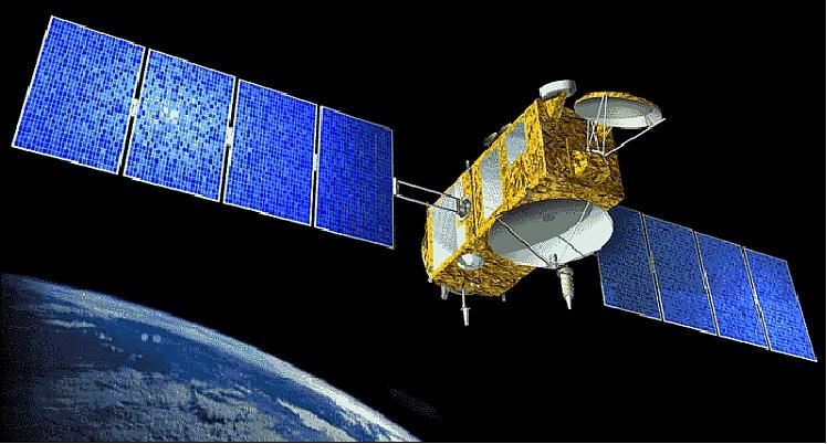
Jason-2/OSTM
EO
Atmosphere
Ocean
NASA
Launched in June 2008, Jason-2, also referred to as the Ocean Surface Topography Mission (OSTM), was the follow-on mission from Jason-1 and Posiedon/TOPEX. In this mission, the National Aeronautics and Space Administration (NASA) and Centre National d’Etudes Spatiales (CNES) worked collaboratively with the National Oceanic and Atmospheric Administration (NOAA) and European Organization for the Exploitation of Meteorological Satellites (EUMETSAT) to extend the existing time series of ocean surface topography measurements. Jason-2 successfully obtained a continuous record of observations in line with previous missions which included measurements of time-averaged ocean circulation, global sea-level change and improved open ocean tide models, until it was decommissioned in October 2019.
Quick facts
Overview
| Mission type | EO |
| Agency | NASA, NOAA, EUMETSAT |
| Mission status | Mission complete |
| Launch date | 20 Jun 2008 |
| End of life date | 10 Oct 2019 |
| Measurement domain | Atmosphere, Ocean, Land, Gravity and Magnetic Fields |
| Measurement category | Gravity, Magnetic and Geodynamic measurements, Atmospheric Humidity Fields, Landscape topography, Ocean topography/currents, Ocean surface winds, Ocean wave height and spectrum |
| Measurement detailed | Atmospheric specific humidity (column/profile), Land surface topography, Wind speed over sea surface (horizontal), Significant wave height, Geoid, Sea level, Ocean dynamic topography, Gravity field |
| Instruments | LRA, AMR, GPSP, POSEIDON-3, DGXX |
| Instrument type | Precision orbit, Imaging multi-spectral radiometers (passive microwave), Radar altimeters |
| CEOS EO Handbook | See Jason-2/OSTM summary |

Summary
Mission Capabilities
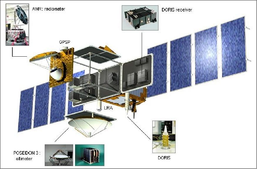
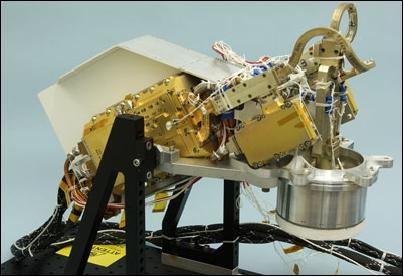
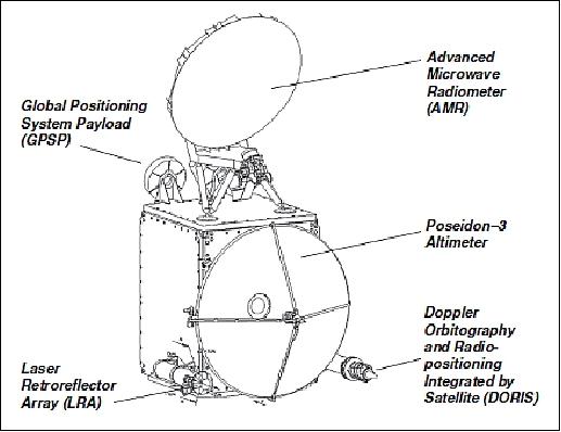
The sensor complement was developed based on the instruments flown on Jason-1, but with significant enhancements to improve performance and reliability. Jason-2 carried five instruments onboard: Positioning Ocean Solid Earth Ice dynamics Orbiting Navigator-3 (Poseidon-3), Advanced Microwave Radiometer (AMR), Doppler Orbitography and Radiopositioning Integrated by Satellite (DORIS), Turbo Rogue Space Receiver-2 (TRSR-2) and Laser Reflector-Array (LRA). Funded by CNES and built by Thales Alenia Space (TAS), the primary instrument, Poseidon-3, was a solid-state radar altimeter which mapped the topography of the sea surface for calculating ocean surface current velocity, measuring ocean wave height and wind speed. It also featured an experimental mode to support measurements closer to coastal zones, lakes and rivers using an open loop tracker. AMR, developed by NASA’s Jet Propulsion Laboratory (JPL), provided a path delay correction for the altimeter. DORIS was a precision orbit determination system used to provide position and ionospheric correction for Poseidon-3, and was developed by CNES and Thomson. Also referred to as the Global Positioning System Payload (GPSP), TRSR-2 was provided by NASA and built by Spectrum Astro Inc. with the objective of providing supplementary positioning data to DORIS in support of the Precision Orbit Determination (POD) and to enhance gravity field models. LRA was a JPL instrument that provided a reference target for satellite laser ranging measurements, necessary for the calibration of POD and Poseidon-3.
In addition to the primary instruments, Jason-2 also carried three auxiliary instruments: Environment Characterization and Modelisation-2 (CARMEN-2), Light Particle Telescope (LPT) and Time Transfer by Laser Link (T2L2).
Performance Specifications
Jason-2 mission objectives required a measurement accuracy of 33 mm with the goal of achieving 25 mm, and to maintain the stability of the global mean sea level measurement with a drift less than 1 mm/year over the life of the mission.
NASA had initially planned to employ a new experimental instrument and interferometric configuration called Wide Swath Ocean Altimeter (WSOA) which could demonstrate ocean topography of 200 km swaths. However this was cancelled by NASA in 2005 due to project cost overruns.
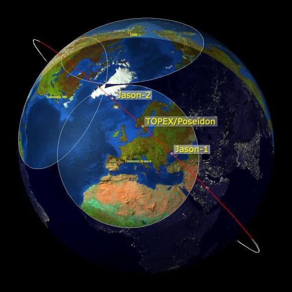
Jason-2 underwent a circular non-sun-synchronous orbit at an altitude of 1336 km and inclination of 66°. It had a period of two hours with a 9.9 day repeat cycle and was able to join Jason-1 in a 10 day repeat cycle which enabled verification and cross-calibration of data.
Space and Hardware Components
Developed with an original design life of five years, Jason-2 employed the Proteus bus developed by CNES/TAS. With a launch mass of approximately 550 kg, it was three-axis stabilised and nadir pointing, maintained by reaction wheels and magnetic torque rods. Power was provided by two solar panels and a hydrazine propellant system was used for orbital maintenance. Communication was provided by S-band radio frequencies with a downlink rate of 838 kbit/s and an uplink rate of 4 kbit/s.
Jason-2 / OSTM
Spacecraft Launch Mission Status Sensor Complement Ground Segment References
Overview
Jason-2 is a follow-on satellite to the joint CNES/NASA oceanography mission Jason (or Jason-1, with a launch Dec. 7, 2001). Jason-1, in turn is a follow-on mission of TOPEX/Poseidon, the ocean surface topography since its launch in 1992 (operations ceased on Oct. 9, 2005).
At NASA and at NOAA, the Jason-2 mission is also referred to as OSTM (Ocean Surface Topography Mission). Initially, NASA/JPL planned OSTM to come with a promising new experimental instrument and interferometric radar configuration (an additional feature to the core mission) called WSOA (Wide Swath Ocean Altimeter). The objective was to demonstrate ocean topography over 200 km swaths (parallel to the regular altimeter mission). 1) 2) 3)
However, this WSOA option was cancelled by NASA in the spring of 2005 due to project cost overruns. Hence, the agreed-upon Jason-2 mission under development in 2005 will simply consist of the core mission configuration. 4)
The science objectives of Jason-2/OSTM are to extend the time series of ocean surface topography measurements to: a) obtain a continuous record of observations (with the previous missions), b) to determine the variability of ocean circulation at decadal time scales from combined data record with T/P and Jason, c) improve the measure of the time-averaged ocean circulation, d) improve the measure of global sea-level change, and e) improve open ocean tide models.
The mission objectives call for the provision of the same measurement accuracy of Jason (3.3 cm) with a goal of achieving 2.5 cm, and to maintain the stability of the global mean sea level measurement with a drift less than 1 mm/year over the life of the mission. The overall goal is to better understand the forces behind global changes of climate and to predict seasonal anomalies in weather patterns; this is vital to understand the physics of the ocean.
Introduction of New Operations Concept for Jason-2/OSTM
While spacecraft operations of Jason-1 are still being conducted by NASA and CNES - the operational function of Jason-2 will be carried out by NOAA and EUMETSAT, respectively (the operators of US and European weather satellites). This programmatic switch of service support from research institutions to operational institutions is a definite sign of a service mature enough to become operational. 5) 6) 7)
The four partners of the Jason-2 mission have agreed on mutual cooperation and division of responsibilities. Project management is still in the hands of NASA and CNES, but now with the support of NOAA and EUMETSAT as partners. This new program organization is expected to reinforce the transition of the Jason-2 mission towards operational applications in the fields of oceanography, marine meteorology, seasonal prediction and climate monitoring.
CNES is providing the Proteus bus of Jason-2, including the altimeter and the DORIS receiver, while NASA delivers the radiometer, the GPS Receiver, and the LRA (Laser Retroreflector Array). NASA procures the launcher and launch services and CNES is in charge of overall system integration. EUMETSAT and NOAA provide Earth terminals and part of the ground network. In addition, they are responsible for near-real-time product processing, archiving, product dissemination and user support. The OSTM Science Working Team selected by the four agencies assists the project in science algorithm development and further calibration and validation activities.
Spacecraft
Jason-2 employs the Proteus bus of CNES/Thales Alenia Sapce and a payload module, with Thales Alenia Space as the prime contractor of the spacecraft. Jason-2 is three-axis stabilized and nadir pointing - maintained by reaction wheels and magnetic torque rods. Power (580 W) is provided by two solar panels. A hydrazine propellant system is being used for orbital maintenance. Jason-2 has a launch mass of about 550 kg; the design life is 5 years. 8)
Platform dry mass, payload mass | 277 kg, 255 kg |
Propellant mass | 28 kg of hydrazine |
Spacecraft launch mass | 553 kg |
Electrical power | 550 W (EOL) |
Spacecraft pointing accuracy | 0.15º (1/2 cone) |
Onboard data storage capacity | 2 Gbit |
Spacecraft design life | 5 years |
RF communications: Downlink data rate at 838 kbit/s (S-band, QPSK modulation), uplink at 4 kbit/s (S-band). The CCSDS communication protocol standard is used in the forward and return link mode (use of virtual channels). Convolutional coding is also applied to telemetry.
Launch
A launch of Jason-2/OSTM took place on June 20, 2008 on a Delta-2-7320-10 launch vehicle from VAFB, CA, USA. The launch provider was ULA (United Launch Alliance).
Orbit
Circular non-sun-synchronous orbit; 1336 km altitude (2 hour period), inclination = 66.038º, 9.9-day repeat orbits (127 revolutions), ground track repeatability = ±1 km cross-track at the equator. The drift of the orbital plane with respect to the inertial reference frame is -2º per day.
Jason-2 is scheduled to join Jason-1 in the same orbit with a 10 day repeat observation cycle(9.9156 days to be precise, i.e., 10 days minus two hours). Both satellites will pass within minutes of each other over the same ocean surface, thus enabling verification and cross-calibration of the collected data. Together, they will provide a vital contribution to the expanding network of global ocean observations and their application in meteorology, operational oceanography and climate monitoring.
Mission Status
• October 4, 2019: The Jason-2/Ocean Surface Topography Mission (OSTM), the third in a U.S.-European series of satellite missions designed to measure sea surface height, successfully ended its science mission on Oct. 1. NASA and its mission partners made the decision to end the mission after detecting deterioration in the spacecraft's power system. 9)
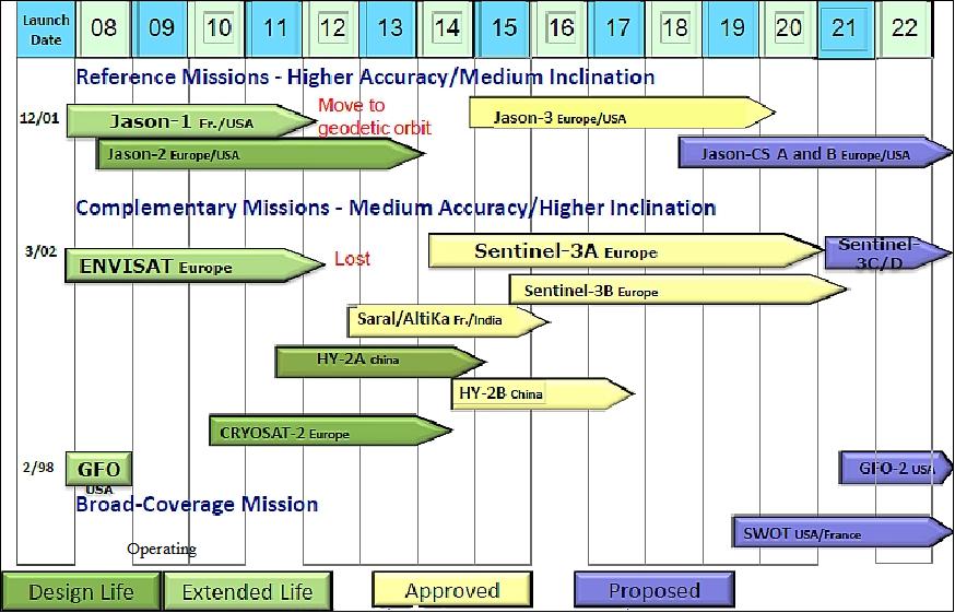
- Jason-2/OSTM, a joint NASA mission with the French space agency Centre National d'Etudes Spatiales (CNES), the National Oceanic and Atmospheric Administration (NOAA), and the European Organisation for the Exploitation of Meteorological Satellites (EUMETSAT), launched in June 2008. The mission extended the long-term record of sea surface height measurements started by the NASA-CNES TOPEX/Poseidon and Jason-1 missions. Jason-2/OSTM’s 11-year lifetime well exceeded its three-year design life. These measurements are being continued by its successor, Jason-3, launched in 2016.
- "Today we celebrate the end of this resoundingly successful international mission," said Thomas Zurbuchen, associate administrator of the Science Mission Directorate at NASA Headquarters in Washington. “Jason-2/OSTM has provided unique insight into ocean currents and sea level rise with tangible benefits to marine forecasting, meteorology and our understanding of climate change.”
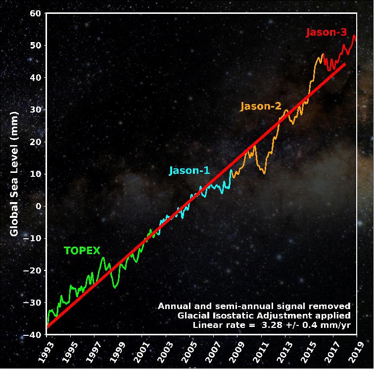
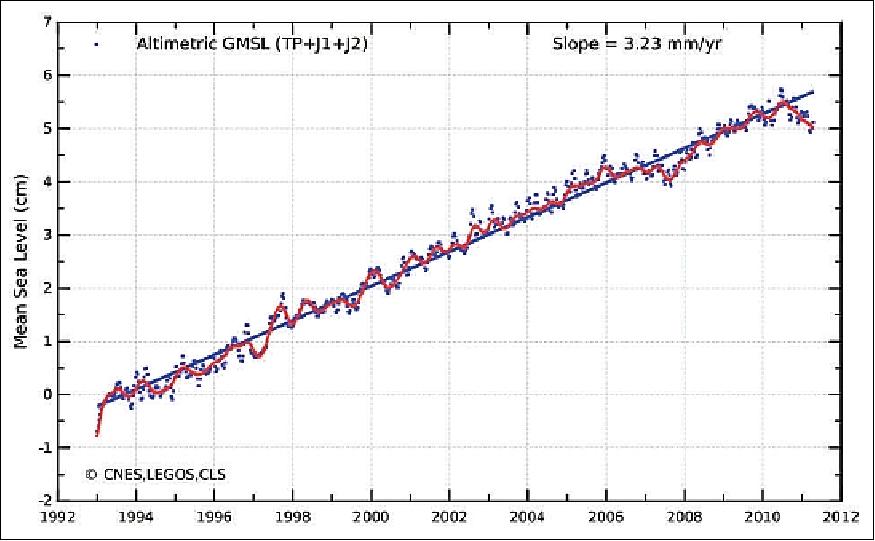
- Since its launch, Jason-2/OSTM charted nearly 5 cm of global sea level rise, a critical measure of climate change. The mission has also resulted in the distribution of over a million data products and the publication of more than 2,100 science papers.
- "Jason-2/OSTM was a high point of operational satellite oceanography as the first Jason mission to formally include EUMETSAT and NOAA as partners," said Steve Volz, assistant administrator of NOAA’s Satellite and Information Service. “During its 11-year run, Jason-2/OSTM helped improve NOAA’s hurricane intensity forecasts and provided important observations of marine winds and waves and in doing so has anchored these essential ocean altimetry observations in NOAA’s operational observing system requirements.”
- With the recent degradation of the spacecraft's power system, mission partners decided to end the mission to decrease risks to other satellites and future altimetry missions, and to comply with French space law. Final decommissioning operations for Jason-2/OSTM are scheduled to be completed by CNES on Oct. 10.
- "With the involvement of EUMETSAT and NOAA, Jason-2 brought high precision monitoring of ocean surface topography and mean sea level to operational status," said Alain Ratier, EUMETSAT's director general. "Its 11-year lifetime in orbit was rewarding for the four program partners and the ocean and climate user community."
- Jason-2/OSTM’s mission might have ended earlier if not for the ingenuity of its mission teams. In July 2017, the degradation of critical onboard components and control systems required that Jason-2/OSTM move from its original science orbit, deplete excess propellant reserves, and be maneuvered into a slightly lower orbit away from functioning satellites. In close collaboration with the Ocean Surface Topography Science Team, mission partners identified an orbit that would allow for the continuation of the Jason-2/OSTM measurements, while still being compatible with orbital debris mitigation constraints and of scientific benefit.
- This new orbit resulted in less frequent observations of the same location on Earth but overall resolution of the data improved because the ground tracks of the observations were closer together. This improved resolution is extremely useful for marine gravity studies and the mapping of seafloor topography. It also allowed for valuable operational oceanographic and science observations.
- "Not only did Jason-2 extend the precise climate record established by TOPEX/Poseidon and continued by Jason-1, it also made invaluable observations for small to medium-scale ocean studies in its second, interleaved orbit," said CNES President Jean-Yves Le Gall. "Even when moved to the 'graveyard' orbit, Jason-2 continued to make unprecedented new observations of the Earth's gravity field, with precise measurements right until the end."
- The technological advancements proven on Jason-1, Jason-2/OSTM, and Jason-3 will be put to use well into future decades. Following Jason-3 will be two future Sentinel-6/Jason-CS satellites, planned for launch in 2020 and 2025.
• June 20, 2018: An international oceanography satellite that is tracking the ongoing rise in global sea level marks its 10th year in orbit today. 10)
- Designed for a three-to-five-year mission, the joint U.S./European Ocean Surface Topography Mission (OSTM) on the Jason-2 satellite has now made more than 47,000 trips around our home planet, measuring sea level change across the globe, observing ocean currents, studying climate phenomena such as El Nino and La Nina, and monitoring the long-term rise in global mean sea level. In January 2016, it was joined in orbit by its follow-on mission, Jason-3. NASA's Jet Propulsion Laboratory in Pasadena, California, manages NASA's portion of both missions.
- In July 2017, Jason-2 began a new science mission when it was maneuvered into a slightly lower orbit. In this new orbit, Jason-2 is collecting data along a series of very closely spaced ground tracks, just 8 km apart. It will take just over a year for Jason-2 to complete one cycle of these new ground tracks, which provide a very accurate and high-resolution estimate of the mean sea surface. The pull of gravity from underwater mountains and other features of the sea floor helps to shape the mean sea surface. These new surface measurements are already being used by scientists to improve maps of the shape and depth of the sea floor, resolving many previously unknown seamounts and other geologic features on the ocean bottom. The new maps will also allow for advances in ocean modeling, naval operations and solid Earth dynamics.
- Jason-2 data from the new orbit are used by operational agencies to provide societal and strategic benefits, such as realtime information used for deriving ocean currents; improving marine, fishery and naval operations; and calculating tropical cyclone heat potential to improve forecasts of the intensity of tropical hurricanes and cyclones.
- "Along with Jason-3, Jason-2 has extended the record of global sea level rise into a third decade," said Glenn Shirtliffe, Jason-2 project manager at JPL.
- NASA is currently working with its partners — ESA (European Space Agency), NOAA (National Oceanic and Atmospheric Administration), CNES (Centre National d'etudes Spatiales) and EUMETSAT (European Organization for the Exploitation of Meteorological Satellites) — on future generations of satellite altimeters. The instruments are projected for launch in the next decade. They include the Sentinel-6/Jason-CS (Jason Continuity of Service) and the SWOT (Surface Water and Ocean Topography) missions.
- "In addition to measuring ocean circulation and revealing the ocean's role in Earth's climate, Jason-2 and Jason-3 measure the rise in global sea level caused by global warming," said Josh Willis, JPL oceanographer and NASA's project scientist for both missions. "Melting ice and expanding seawater drive global sea levels higher and higher each year. The rise has become a powerful reminder of how fast humans are changing the climate. These missions keep our finger on the pulse of climate change."
- Other significant science results from the Jason-2 mission include studies of ocean circulation; the ties between the ocean and the atmosphere; and improved global climate forecasts and predictions.
- "The 10th anniversary of the launch of Jason-2 is also a landmark in the development of operational oceanography, as this was the first Jason mission involving two operational agencies, EUMETSAT and NOAA," said EUMETSAT Director-General Alain Ratier. "This paved the way for the transition from highly successful research missions to an operational altimeter system, which has now turned to reality with Jason-3, Jason-CS/Sentinel-6 and Sentinel-3 providing data until 2030."
- "After 10 years of excellent service, we're excited that Jason-2 is continuing to help forecast hurricane intensity and monitor winds and waves, while taking on a new mission of mapping unexplored parts of the ocean," said Eric Leuliette, NOAA's Jason program and project scientist.
• June 30, 2017: The Jason-2/OSTM partnership mission of NASA, NOAA, CNES and EUMETSAT marked its ninth year in orbit on June 20. Designed to fly three to five years, Jason-2/OSTM has now completed more than 42,000 trips around our planet, contributing to a database of satellite altimetry that dates back to the launch of the U.S./French Topex/Poseidon satellite in 1992. 11)
- Over the past nine years, Jason-2/OSTM has precisely measured the height of 95 percent of the world's ice-free ocean every 10 days. Since its launch in June 2008, it has measured a 4 cm increase in global mean sea level, which has been rising at a rate of about 3 mm a year since satellite altimetry records began in 1993. It has also tracked changes in regional sea level; monitored the speed and direction of ocean surface currents; enabled more accurate weather, ocean and climate forecasts; and observed multiple El Niño and La Niña events. Since October 2016, it has operated in a tandem mission with its successor, Jason-3, launched in January 2016, doubling coverage of the global ocean and improving data resolution for both missions.
- But as Jason-2/OSTM's onboard systems age and key components begin to show signs of cumulative space radiation damage, it has become prudent to move the older satellite out of its current shared orbit with Jason-3. On June 20, Jason-2's four mission partner agencies agreed to lower Jason-2's orbit by 27 km in early July, from 1,336 to 1,309 km, placing it in a new orbit with a long repeat period of just more than one year. The move is designed to safeguard the orbit for Jason-3 and its planned successor, Jason-CS/Sentinel-6, planned for launch in 2020.
- In its new orbit, Jason-2/OSTM will also undertake a new science mission. The long-repeat orbit will allow Jason-2/OSTM to collect data along a series of very closely spaced ground tracks just 8 km apart. The result will be a new, high-resolution estimate of Earth's average sea surface height.
- The shape of the sea surface is partly determined by underwater hills and valleys, which pull the water due to the force of gravity. Scientists will use these new Jason-2/OSTM data to improve maps of the shape and depth of the sea floor, resolving many presently unknown seamounts (underwater mountains) and other geologic features on the ocean bottom. These new maps will permit advances in ocean modeling, tsunami wave forecasting, and naval operations support, and will boost understanding of the dynamics of the solid Earth.
- The data will also help prepare for the next generation of global satellite altimetry missions, including the NASA/CNES/Canadian Space Agency/UK Space Agency SWOT (Surface Water and Ocean Topography) mission, planned for launch in 2021; and Sentinel-3B, to be launched by the European Space Agency in early 2018.
- "It's still too early for OSTM/Jason-2 to sail off into the sunset," said OSTM/Jason-2 and Jason-3 Project Scientist Josh Willis of NASA/JP ( Jet Propulsion Laboratory) in Pasadena, California. "The ocean covers more than 71 percent of Earth's surface, so improving our knowledge of the shape of the sea floor is like mapping a whole new world. These new data will also help pave the way for satellite altimetry missions that don't need to follow traditional satellite ground tracks."
- While OSTM/Jason-2 is leaving its old orbit, data from its new orbit will continue to be used by operational agencies to provide societal and strategic benefits ranging from deriving ocean currents and improving marine, fishery and naval operations; to assisting in forecasting the intensity of tropical hurricanes and cyclones by identifying regions of high thermal energy in the ocean.
• June 28, 2017: The Jason-2 high-precision ocean altimetry mission launched in 2008 and exploited in partnership with NOAA, NASA and CNES was extended for two years, from 1 January 2018 until the end of 2019, to complement Jason-3, operational since July 2016. 12) 13)
- The Council also welcomed Ireland as the 16th Participating State in the Jason-CS Program, the contribution of EUMETSAT to the cooperative Sentinel-6 mission expected to replace Jason-3 in 2021. The mission involves also ESA, the European Union and the United States through NASA and NOAA.
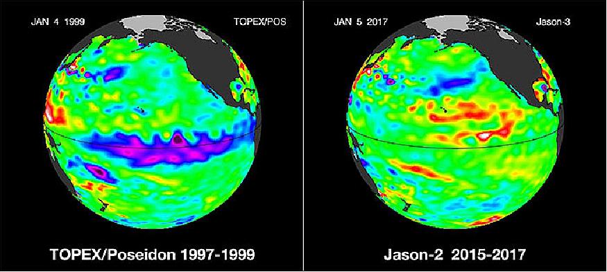
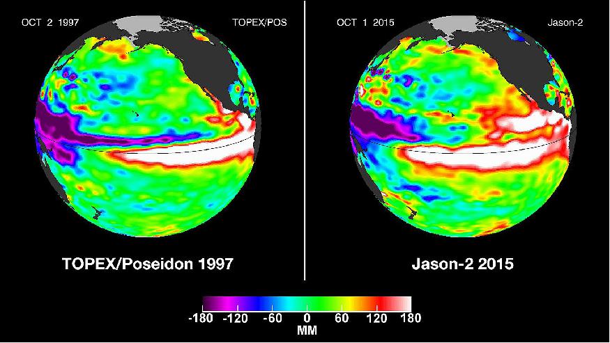
• January 5, 2017: The super El Niño of 2015-2016 is waning. Here we provide side by side comparisons of Pacific Ocean SSH (Sea Surface Height) anomalies of what is presently happening to the Pacific Ocean El Niño signal with the famous 1997-1998 El Niño (which peaked in November 1997). The present El Niño, which peaked in January 2016, was longer lasting than the 1997-1998 episode and was larger in area. The El Niño of 2015-2016 was similar to the Niño of 1997-1998, but not an exact repeat. Each El Niño episode has a unique timing and variations in impacts. Also, remember that 2014 – 2015 was a weak, central Pacific Niño, so this one had a jump start. The El Niño of 2015-2016 was a continuing El Niño that first appeared in 2014-2015. Comparing present conditions with 1997-1998, a large area of the northeastern tropical Pacific (north of the equator) still contains a large area of positive (warmer than normal) heat content. The El Niño footprint is still strong. Looking ahead, many El Niño experts expect a transition to a La Niña, the cool sibling of El Niño. They put the probability of La Niña developing this summer or early fall at 70%. Stay tuned! 14)
- These 1997-1999 and 2015-2017 El Niño animations were made from data collected by the TOPEX/Poseidon (1997-1998) and the OSTM/Jason-2 (2015-2016) satellites. In January 2016, the Jason-3 mission was successfully launched and is already operational. Jason-2 and Jason-3 continue to provide an uninterrupted time-series that originated in 1992 with TOPEX/Poseidon. For the past 24 years, TOPEX/Poseidon, Jason-1, Jason-2 and Jason-3 have used space-based radar altimetry to collect sea surface height data of all the world's oceans. Here, these images are processed to highlight the interannual signal of SSH. The mean signal, seasonal signal, and the trend have been removed.
• October 17, 2016: The Jason-2/OSTM satellite has successfully completed its transfer to the interleaved orbit. The mission is now on the targeted ground track and the Poseidon-3 altimeter is back to operation since October 14th, 20:00:00 UTC. 15)
- From 2008 to Oct.2016, Jason-2 wa located on its nominal orbit. From Oct.2016 (at the end of cycle 303), after more than 8 years of service on this nominal ground track, Jason-2 swiched to the interleaved orbit that was used by Topex from 2002-2005 and by Jason-1 from 2009-2012.
• Sept. 22, 2016: The Jason-2/OSTM satellite will be moved to a new ground track in early October, after the end of repeat cycle 303. - The satellite spent more than eight years of service on the nominal ground track. 16)
- The Jason-3 satellite will continue the long term climate data record on the primary TOPEX, Jason-1 and Jason-2 ground track.
- The Jason-2 satellite will be moved to the same interleaved orbit that was used by TOPEX from 2002–2005 and Jason-1 from 2009–2012.
- Several maneuvers will be performed beginning on 2 October 2016, with the interleaved orbit achieved by 14 October 2016.
• Dec. 29, 2015: The current strong El Niño brewing in the Pacific Ocean shows no signs of waning, as seen in the latest satellite image from the U.S./European Ocean Surface Topography Mission (OSTM)/Jason-2 mission. El Niño 2015 has already created weather chaos around the world. Over the next few months, forecasters expect the United States to feel its impacts as well. 17)
- The images show nearly identical, unusually high sea surface heights along the equator in the central and eastern Pacific: the signature of a big and powerful El Niño. Higher-than-normal sea surface heights are an indication that a thick layer of warm water is present.
- El Niños are triggered when the steady, westward-blowing trade winds in the Pacific weaken or even reverse direction, triggering a dramatic warming of the upper ocean in the central and eastern tropical Pacific. Clouds and storms follow the warm water, pumping heat and moisture high into the overlying atmosphere. These changes alter jet stream paths and affect storm tracks all over the world.
- This year's El Niño has caused the warm water layer that is normally piled up around Australia and Indonesia to thin dramatically, while in the eastern tropical Pacific, the normally cool surface waters are blanketed with a thick layer of warm water. This massive redistribution of heat causes ocean temperatures to rise from the central Pacific to the Americas. It has sapped Southeast Asia's rain in the process, reducing rainfall over Indonesia and contributing to the growth of massive wildfires that have blanketed the region in choking smoke.
- The new Jason-2 image shows that the amount of extra-warm surface water from the current El Niño (depicted in red and white shades) has continuously increased, especially in the eastern Pacific within 10 degrees latitude north and south of the equator. In the western Pacific, the area of low sea level (blue and purple) has decreased somewhat from late October. The white and red areas indicate unusual patterns of heat storage. In the white areas, the sea surface is between 6 and 10 inches (15 to 25 cm) above normal, while in the red areas, it is about 4 inches (10 cm) above normal. The green areas indicate normal conditions. The height of the ocean water relates, in part, to its temperature, and is an indicator of the amount of heat stored in the ocean below.
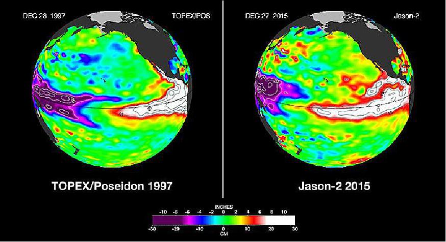
Legend to Figure 9: Interest in the present developing 2015 El Niño is high. Here we provide side by side comparisons of Pacific Ocean SSH (Sea Surface Height) anomalies of what is presently happening in 2015 with the Pacific Ocean signal during the famous 1997 El Niño. These 1997 and 2015 El Niño animations were made from data collected by the TOPEX/Poseidon (1997) and the OSTM/Jason-2 (2015) satellites. Jason-2 continues to provide an uninterrupted time-series that originated in 1992 with TOPEX/Poseidon. TOPEX/Poseidon, Jason-1 and Jason-2 are using spaceborne radar altimetry to collect sea surface height data of all the world's oceans.
• October 2015: Every two to seven years, an unusually warm pool of water — sometimes 2 to 3º Celsius higher than normal — develops across the eastern tropical Pacific Ocean to create a natural short-term climate change event. This warm condition, known as El Niño, affects the local aquatic environment, but also spurs extreme weather patterns around the world, from flooding in California to droughts in Australia. This winter, the 2015-16 El Niño event will be better observed from space than any previous El Niño. 18)
- This year's El Niño is already strong and appears likely to equal the event of 1997-98, the strongest El Niño on record, according to the WMO (World Meteorological Organization). All 19 of NASA's current orbiting Earth-observing missions were launched after 1997. In the past two decades, NASA has made tremendous progress in gathering and analyzing data that help researchers understand more about the mechanics and global impacts of El Niño.
- "El Niño is a fascinating phenomenon because it has such far-reaching and diverse impacts. The fact that fires in Indonesia are linked with circulation patterns that influence rainfall over the United States shows how complex and interconnected the Earth system is," said Lesley Ott, research meteorologist at NASA/GSFC (Goddard Space Flight Center), Greenbelt, Maryland.
- Using NASA satellite observations in tandem with supercomputer processing power for modeling systems, scientists have a comprehensive suite of tools to analyze El Niño events and their global impacts as never before. Throughout this winter, NASA will share the latest scientific insights and imagery updates related to El Niño.
- For instance, scientists are learning how El Niño affects the year-to-year variability for fire seasons in the western United States, Amazon and Indonesia. El Niño may also affect the yearly variability of the ground-level pollutant ozone that severely affects human health. Researchers will be keenly focused on how the current El Niño will affect the drought in California.
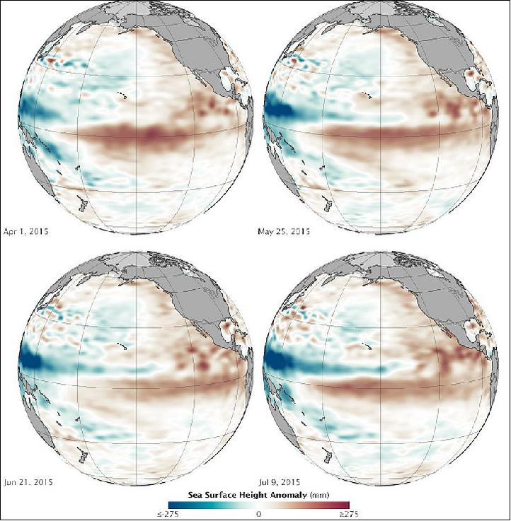
• August 5, 2015: When scientists declared in March 2015 that El Niño conditions had developed in the Pacific Ocean, the consensus was that the event was too weak and too late to have much effect on North America. But in the past several months, warm water has been sloshing from the western Pacific toward the Americas and El Niño has strengthened. Surface waters have grown significantly warmer in the central and eastern Pacific, and conditions have become somewhat cooler and drier in the west. By the end of July 2015, scientists at NASA and other agencies started to see some similarities between current conditions and the development of the potent El Niño event of 1997–98. 19)
- The maps of Figure 11 provide NASA’s view of Pacific Ocean conditions. The maps show snapshots of the averaged sea surface height anomalies at four different moments since March 2015. Shades of red indicate where the ocean stood above normal sea level because warmer water expands to fill more volume (thermal expansion). Shades of blue show where sea level and temperatures were lower than average (thermal contraction). Normal sea-level conditions appear in white. The maps are based on altimetry measurements made by the OSTM/Jason-2 satellite and analyzed by scientists at NASA’s Jet Propulsion Laboratory.
- This El Niño is getting billed as the ‘great wet hope.’ Many people in the American West are looking to El Niño to save them from drought. El Niño typically peaks between December and April, so only time will tell if this event will be potent. Many of the models and observations suggest it will be, but other factors such as the “warm blob” in the North Pacific and the apparent shift in the Pacific Decadal Oscillation could affect further development.
- Scientists from NASA’s Goddard Space Flight Center and other institutions recently found that California has accumulated a “rain debt” of about 50 cm between 2012 and 2015. That is the amount that would normally fall in an entire year in the state.
• March-April 2015: In its seventh year on orbit, CNES and EUMETSAT have approved the Jason-2 mission to be extended up to 2017 and it is anticipated that NASA will give similar approval during the 2015 Earth Science Senior Review, which should conclude this summer. Although Jason-2 is performing well, the project requested consideration of an Extension of Life (EOL) phase when the risk of losing control of the satellite becomes high. 20)
• January 2015: The Jason-2/OSTM mission operations are nominal. However, the Jason-2 mission (launch June 20, 2008) is in 2015 already beyond its design life of 5 years.
- The launch of the Jason-3 mission will probably be delayed from the scheduled March 2015 launch to mid-2015 due to delays in NASA’s certification of the Space Exploration Technologies Corp. Falcon 9 rocket that will carry Jason-3. The launch of Jason-3 will most likely be delayed due to a combination of SpaceX CRS-6 [space station cargo supply] acceleration in the production queue for the launch vehicle, range availability and to ensure readiness to launch the mission. 21)
• May 14, 2014: Data from ocean-observing satellites and other ocean sensors indicate that El Niño conditions appear to be developing in the equatorial Pacific Ocean. Conditions in May 2014 bear some similarities to those of May 1997, a year that brought one of the most potent El Niño events of the 20th century. 22)
During an El Niño, easterly trade winds in the Pacific falter and allow giant waves of warm water—known as Kelvin waves—to drift across from the western Pacific toward South America. Surface waters in the central and eastern Pacific become significantly warmer than normal, altering weather patterns and affecting fisheries along the west coasts of the Americas. El Niño also can have a significant influence on weather and climate far from the tropics.
The maps of Figure 12 show the ten-day average of sea surface height centered on May 2, 1997 (left), and May 3, 2014. Shades of red and orange indicate where the water is warmer and above normal sea level. Shades of blue-green show where sea level and temperatures are lower than average. Normal sea-level conditions appear in white. The 1997 map was assembled from data collected by the TOPEX/Poseidon satellite, while the 2014 data comes from the Jason 2/OSTM (Ocean Surface Topography Mission) satellite.
The height of the sea surface is a good indicator of the amount of heat stored in the water. As the ocean warms, the surface rises; as it cools, its falls. This is due to thermal expansion and contraction; the molecules in warmer water are farther apart than in cooler water. Above-normal sea surface heights in the equatorial Pacific indicate El Niño conditions, while below-normal heights indicate La Niña.
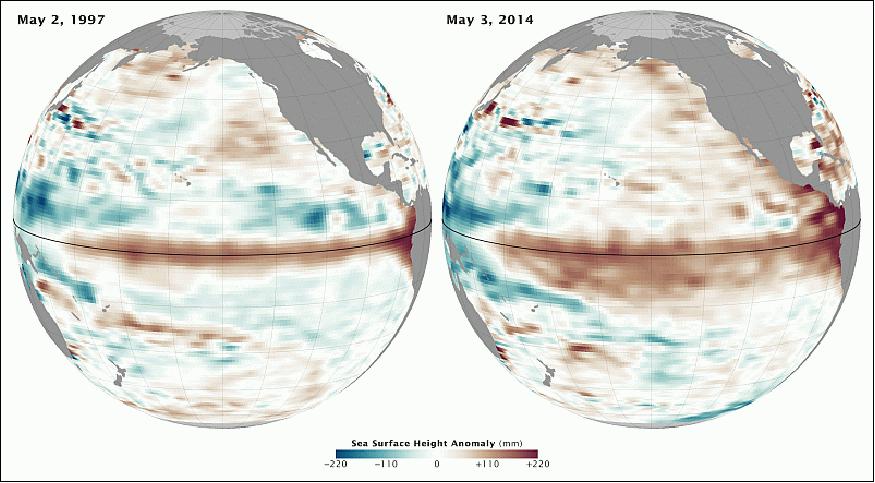
The years 1997–98 brought El Niño out of the scientific literature and onto the front pages and evening newscasts. It was one of the strongest El Niño events observed, with extreme weather impacts on several continents. North America had one of its warmest and wettest winters on record, particularly in California and Florida. Peru, Mexico, and the rest of Central and South America endured devastating rainstorms and flooding. Indonesia and parts of Asia saw disastrous droughts.
Scientists at the Climate Prediction Center of the National Weather Service (NWS) announced on May 8 that they foresee a 65% chance of a transition to El Niño in the summer of 2014. “There remains uncertainty as to exactly when El Niño will develop and an even greater uncertainty as to how strong it may become,” NWS reported.
• The Jason-2/OSTM spacecraft and its payload are operating nominally in 2014.
• June 2013: The 2013 Senior Review evaluated 13 NASA satellite missions in extended operations: ACRIMSAT, Aqua, Aura, CALIPSO, CloudSat, EO-1, GRACE, Jason-1, OSTM, QuikSCAT, SORCE, Terra, and TRMM. The Senior Review was tasked with reviewing proposals submitted by each mission team for extended operations and funding for FY14-FY15, and FY16-FY17. Since CloudSat, GRACE, QuikSCAT and SORCE have shown evidence of aging issues, they received baseline funding for extension through 2015. 23)
- The mission extension of Jason-2/OSTM is rated as Low Risk. The Technical Review Panel has identified 2 Major Strengths, 2 minor strengths, no Major Weaknesses and no minor weaknesses that influence the risk determination. The Jason-2/OSTM instrument systems continue to perform very well and all retain full redundant. The OSTM bus has operated exceptionally well providing high confidence that it will remain fully functional during the proposed mission extension period until the end of 2015. - Also, the 3 passenger payloads: Carmen-2 (Environment Characterization and Modelisation-2), LPT (Light Particle Telescope), and the T2L2 (Time Transfer by Laser Link) continue to perform very well with redundancy.
• June 20, 2013, marked the fifth anniversary of the launch of the OSTM (Ocean Surface Topography Mission) on the Jason-2 satellite from Vandenberg Air Force Base in California. In just a few hours after its early morning launch, the spacecraft had made its first full revolution around Earth. The satellite has now made more than 25,550 orbits around our planet, keeping its highly accurate radar altimeter tuned to measure changes in the dynamic topography of our ocean. Day-by-day, month-by-month, and year-after-year, Jason-2 has continued to seamlessly add to the more than 20-year record of global sea surface height measurements begun by TOPEX/Poseidon in 1992. 24)
• The Jason-2/OSTM spacecraft and its payload are operating nominally in early 2013.
• Sept. 2012: The current OSTM/Jason-2 mission status is OK. 25)
- Stationkeeping maneuvers: The equatorial nodal crossing requirement calls for ±1 km deviation (max) from reference nodes. The Jason-2 stationkeeping maneuvers are made with only one thrust above land on any orbit. The remaining propellent is > 23 kg.
- The core payload () Poseidon-3, DORIS, AMR, GPS) is fully operational after > 4 years on orbit; the passenger payloads (T2L2, CARMEN-2, LPT) perform satisfactorily.
- The global Jason-2 system availability is 99.9%.
• June 20, 2012 marked 4 years on-orbit of the Jason-2/OSTM spacecraft. 26)
- Several significant events occurred which impact the altimetry constellation. The Envisat mission of ESA ended on April 8, 2012, exactly two years after the launch of their Cryosat-2 satellite. Jason-1 suffered a pair of safehold events in the spring of 2012, and for safety reasons wasmoved to a new geodetic orbit with a long 406-day repeat period. Routine generation of Jason-1 data resumed on May 7, 2012. Operational users, as well as researchers, have had to adapt their processing to exploit Jason-1 data in its geodetic orbit as well as Cryosat-2 data in lieu of Envisat.
- The contributions of Jason-2 to the altimetry constellation have become more important than ever, as the Jason-3 and Jason-CS (Jason-Continuity of Service) missions are being developed to ensure the continuity of observational services for operational applications as well as climate assessment. 27)
• The Jason-2/OSTM spacecraft and its payload are operating nominally in early 2012 after more than 3 ½ years on orbit. The global Jason-2 system availability is 99.9%. The passenger (auxiliary) payloads (T2L2, Carmen-2, LPT) are performing satisfactorily. The DORIS receiver is functioning nominally. 28) 29)
- The Jason-2/OSTM mission extension is rated as Low Risk for a two-year and four-year extension. In June 2011, the NASA Earth Science Senior Review recommended an extension of the Jason-2/OSTM mission as baseline to 2013 and for another baseline to 2015. 30)
The Technical Review team has identified 2 major strengths, 3 minor strengths and 3 minor weaknesses that influence the risk determination. All of the Jason-2 primary instruments have operated without incident for the 3-year primary mission and retain full as-launched redundancy. The spacecraft is in excellent health, remains fully redundant and is expected to survive for several more years. The DORIS instrument is performing well. The AMR instrument has operated without incident to date and retains full redundancy (Ref. 30).
• Jason-2 is operating nominally in 2011. NOAA continues to operate the satellite from Suitland , MD. Data is processed by NOAA, EUMETSAT, and CNES and the products are being provided to the users well above the requirements. 31)
On June 20, 2011, Jason-2 was 3 years on orbit - providing state-of-the-art data to more than 2,000 teams around the world for use in a wide range of studies and applications.. Since the beginning of the mission data availability is very high thanks to a very reliable system and associated ground procedures. In average, only 0.18% of data are missing since launch - and this very low number is mainly related to planned operations (altimeter software upload, routine calibrations, ...). 32) 33)
• The Jason-2 spacecraft and its payload are operating nominally in 2010. 34) 35) 36)
• The Jason-2 spacecraft and its payload are operating nominally in 2009. 37)
• The Jason-2 ground tracks are maintained within ±1 km from the reference grid. Improvement wrt Jason-1: for Jason-2 station keeping, maneuvers are made with only one thrust above Earth on any orbit (with 2 thrusts and on the last orbit of the 10-day cycle for Jason-1). 38) 39)
• Starting shortly after the launch of Jason-2 in June 2008, both spacecraft, Jason-1 and Jason-2 attained tandem orbits with about 1 minute shift. Jason-1 and Jason-2 started their coordinated science operations on July 12, 2008 with cycle 240 (Jason-1) and cycle 01 (Jason-2).
However, in mid-February 2009 (starting on repeat cycle 262), Jason-1 assumed a new orbit midway between its original ground tracks but with a time lag of approximately 5 days with Jason-2 (hence, the start time of Jason-1 and Jason-2 differ now by about 5 days). This new tandem configuration better suits for real-time applications. The former TOPEX/Poseidon ground tracks are now being overflown by the Jason-2 spacecraft. The orbit change implies also that Jason-2 is from now on regarded the prime spacecraft of the mission.
• Jason-2 mission declared operational: On Dec. 15, 2008, the new Jason-2 OGDR (Operational Geophysical Data Record) service started. After five months of calibration and validation activities an international team of scientists, including representatives from NOAA, EUMETSAT and CNES, declared the near real-time Jason-2 data were ready for public distribution.
Jason-2 products are now available and distributed to operational meteorology users in near-real time (~ three hours delay after reception). Climate users will have access to offline data later in 2009.
• On Oct. 29, 2008, CNES handed over to NOAA the monitoring and control function of Jason-2 for the start of routine operations. This was preceded by four months of tests and qualification of the entire satellite and the ground segment by CNES. 40)
• As of early August 2008, Jason-2 begins mapping the oceans. The first complete maps were calculated from the first 10 days of Jason-2's operational orbit starting on July 4, 2008.
• On July 4, 2008, Jason-2 reached its operational orbit some 1,336 km above the Earth at a 66º inclination. The Jason-2 orbit is just 58 seconds behind that of Jason-1. Jason-1 and Jason-2 will now fly in formation for a few months, making nearly simultaneous measurements to allow scientists to precisely calibrate Jason-2's instruments. This will allow Jason-2 to become fully operational by the end of 2008.
Sensor Complement
The sensor complement is based on the one flown on Jason-1 but with significant enhancements to improve performance and reliability to progress the sensor suite towards an operational capability. 42) 43)
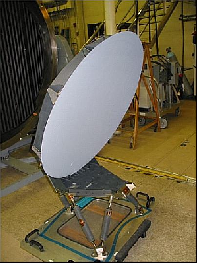
Poseidon-3 (Solid-State Radar Altimeter)
Poseidon-3 is funded by CNES and of Poseidon-2 heritage (built by Thales Alenia Space). Poseidon-3 is a dual-frequency (5.3 and 13.6 GHz) nadir-looking radar altimeter with the objective to map the topography of the sea surface for calculating ocean surface current velocity and to measure ocean wave height and wind speed. Poseidon-3 has a measurement precision identical to its predecessor Poseidon-2.
Transmission frequencies | 5.3 GHz (C-band), 13.575 GHz (Ku-band) |
Transmitted pulse width | 105.6 µs |
Bandwidth | 320 MHz (Ku-band and C-band) |
PRF (Puls Repetition Frequency) | 2060 Hz interlaced (3 Ku-1C- 3 Ku-band) |
Peak output power | 8 W for Ku-band, 25 W for C-band |
Max. RF power output to antenna | 38.4 dBm Ku-band, 42 dBm for C-band |
Antenna diameter | 120 cm |
Antenna beamwidth | 1.28º (Ku-band), 3.4º (C-band) |
Noise figure | 3.2 dB (Ku-band), 0.9 dB (C-band) |
Data rate | 22.5 kbit/s including waveform data and onboard parameters |
Redundancy | Yes |
Special features | Solid-State Power Amplifier (SSPA). |
In addition, Poseidon-3 features an experimental mode to support measurements closer to coastal zones, as well as on lakes and rivers. This will be achieved by an open loop tracker: the satellite to surface distance will be estimated by the altimeter using the real-time orbit position predicted by DIODE (on board navigator based on DORIS receiver) and using the elevation of the surface with respect to the Earth GRIM5 geoid stored in a DEM (Digital Elevation Model) within the altimeter. The instrument's RFU is recurrent from Poseidon-2, while the PCU (Processing & Control Unit) largely reuses electronics from the SIRAL radar altimeter on the CryoSat mission of ESA.
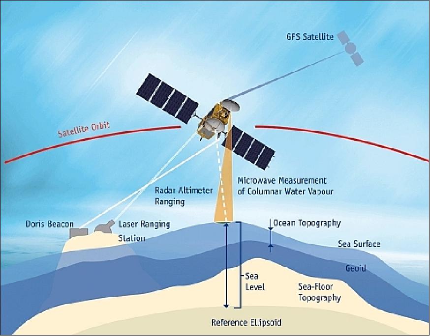
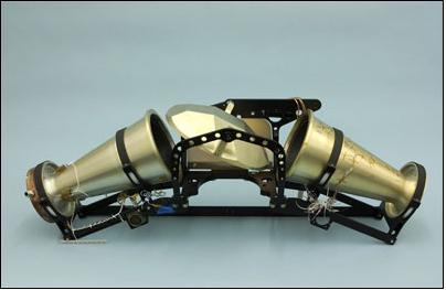
AMR (Advanced Microwave Radiometer)
AMR is a JPL instrument of TMR and JMR (Jason Microwave Radiometer) heritage. AMR is a passive microwave radiometer measuring the brightness temperatures in the nadir column at 18.7, 23.8, and 34 GHz, providing path delay correction for the altimeter (the brightness temperatures are converted to path-delay information). The 23.8 GHz channel is the primary water vapor sensor, the 34 GHz channel provides a correction for non-raining clouds, and the 18.7 GHz channel provides the correction for effects of wind-induced enhancements in the sea surface background emission. 44) 45)
The AMR consists of two subsystems: ESA (Electronics Structure Assembly) and RSA (Reflector Structure Assembly). The ESA is developed by JPL, while the RSA is developed by ATK Space Systems, San Diego, CA.
DORIS (Doppler Orbitography and Radiopositioning Integrated by Satellite)
DORIS is a CNES/Thomson development. DORIS is a precision orbit determination system providing position and ionospheric correction for Poseidon-2. Doris measurements are also used for geophysical studies, in particular through the International Doris Service (IDS). Doris is a dual-frequency instrument able to determine atmospheric electron content. 46)
The DORIS flight segment consists of a two-channel, two-frequency (401.25 MHz and 2036.25 MHz) Doppler receiver capable of tracking signals from a worldwide network of about 50 ground beacons. The Jason-2 DORIS-DIODE (Immediate Onboard Orbit Determination by Doris) receiver is the same second generation device as the one developed for the ENVISAT mission. Its main functional improvements over first-generation receivers are its capability to receive two beacons simultaneously and to produce onboard the orbit ephemeris in real time with a precision of 1 m. The receiver is controlled by an ultra-stable oscillator delivering the reference frequency with a stability of 5 x 10-13 over a 10-100 second interval and delivering an on-board time output within 0.1 ms accuracy. The DORIS instrument mass is 31 kg, power = 30 W. 47) 48)
• Seven dual-frequency channels providing a capacity to track up to 7 beacons simultaneously (Ref. 38)
- Increases data quantity
- Makes available low elevation measurements
- Improves pass distributions.
• Hardened USO. Frequency stability through SAA providing a better quality of MOE. Jason-2 is useful for beacon locations.
• New DIODE navigation software
- No more numerical limitation thanks to ERC32 processor
- Improved accuracy better quality of NRT products (OGDR).
TRSR-2 (Turbo Rogue Space Receiver-2)
TRSR-2 is also referred to as GPSP (Global Positioning System Payload). The instrument is of GPS/MET (Microlab) heritage (of a design as flown on CHAMP) and is being provided by NASA/JPL and built by Spectrum Astro Inc. of Gilbert, AZ. BlackJack is a 16-channel GPS receiver with the objective to provide supplementary positioning data to DORIS in support of the POD (Precision Orbit Determination) function and to enhance and/or improve gravity field models. Radial accuracies of 1-2 cm are obtained in post-processing. TRSR-2 is a fully redundant unit (two independent receivers operating in cold redundancy). Each unit is comprised of an omnidirectional antenna, low-noise amplifier, crystal oscillator, sampling down-converter, and a baseband digital processor assembly, communicating through a 1553 bus interface. Instrument mass = 10 kg (2), power = 17.5 W.
In its current configuration, the TRSR-2 on Jason-2 can track up to 16 GPS satellites simultaneously in dual-frequency mode. From these signals, BlackJack acquires measurements of the GPS carrier phase providing range measurements with an accuracy of about 1 mm; the absolute pseudo range (defined as the absolute range plus receiver time offset from GPS time) has an accuracy of about 10 cm. TRSR-2 provides also onboard solutions for S/C position and time, accurate to about 50 m and 150 ns, respectively. 49)
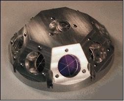
LRA (Laser Retroreflector Array)
LRA is a JPL instrument of TOPEX/Poseidon heritage, built by ITE Inc. under NASA/GSFC contract. LRA provides a reference target for satellite laser ranging (SLR) measurements, which are necessary to calibrate the POD system and the altimeter throughout the mission. The LRA is placed on the nadir face of the satellite. It is a totally passive unit that consists of nine quartz corner cubes arrayed as a truncated cone with one in the center and the other eight distributed azimuthally around the cone. This arrangement allows laser ranging at FOV (Field-of-View) angles of 360º in azimuth and 60º elevation around the perpendicular. The retroreflectors are optimized for a wavelength of 532 nm (green), offering a FOV of about 120º. The LRA instrument mass is 2.2 kg.
The LRA is a passive instrument that acts as a reference target for laser tracking measurements performed by ground stations. Laser tracking data are analyzed to calculate the satellite's altitude to within a few millimeters. However, the small number of ground stations and the sensitivity of laser beams to weather conditions make it impossible to track the satellite continuously. That is why other onboard location systems are needed.
Auxiliary Instruments
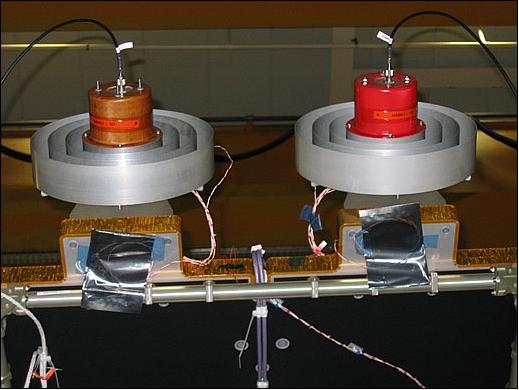
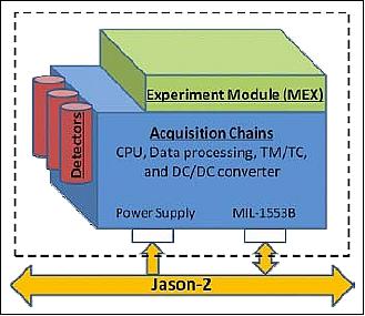
Carmen-2 (Environment Characterization and Modelisation-2)
These are radiation detectors developed by CNES. The Carmen-2 instrumentation is dedicated to study the influence of space radiation on advanced components to measure e-, p+ (high-energy particle flux of electrons and protons) and ion fluxes in the energy ranges responsible for component effects (as ionizing dose, single event effect and displacement damage), to measure associated effects on test components, to characterize the local radiation environment for DORIS USO and to evaluate its potential drifts inside the SAA.
The instrument is composed of a spectrometer (detectors and acquisition chains) and an experiment module (MEX). The energy range for electrons is expected to be 250 keV to 4 MeV. One for protons is 8 to 120 MeV/(mg/cm2). MEX includes three types of dosimeters to measure accurately the exposed dose and several components under test which are memories, linear and optoelectronic devices, power MOSFETs and so on. 50) 51)
The instrument was powered on on June 22, 2008 and is performing well since then (Ref. 38).
LPT (Light Particle Telescope)
LPT is a detection unit of JAXA (Japan Aerospace Exploration Agency), Tokyo, Japan. LPT complements the radiation measurements of Carmen-2. In June 2006, JAXA and CNES signed a MOU (Memorandum of Understanding) with the intent to load the JAXA instrument LPT (Light Particle Telescope) onto the Jason-2 spacecraft of CNES. 52)
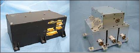
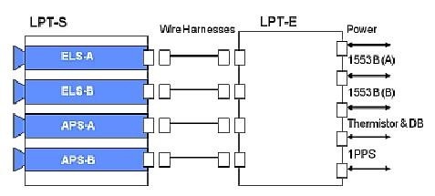
LPT consists of two units, which are LPT-E and LPT-S. Figure 25 shows the external views of LPT-E (left) and LPT-S (right). A block diagram of LPT is shown in Figure 26. LPT-E is mounted inside of the satellite and LPT-S is outside.
LPT-E provides functions of the electrical I/F with the Jason-2 satellite system. It receives primary power supply from satellite system and provides sensors and electrical circuits with secondary power. It also receives telecommands and sends telemetry data via the MIL-1553B bus using protocols specified by the PROTEUS standard satellite bus which is used for the Jason-2.
LPT-S consists of four sensors. Specifications of each sensor are shown in Table 3. Each sensor counts number of interesting particles irradiated from inside of the view angle with the specific energy of each channel every one second (time resolution).
Name | Configuration | Measurement range | No of channels | FOV (Field of View) |
ELS-A | 4 SSD | e-: 22 keV - 1.2 MeV | 20 | ±10.0 |
ELS-B | 1 SSD, GSO+PMT | e-: 0.4 - 19 MeV (TBD) | 13 | ±16.7 |
APS-A | 3 SSD | p: 0.27 - 33MeV | p: 20 | ±16.8 |
APS-B | 4 SSD | p: 1.3 - 230MeV | p: 12 | ±14.0 |
The LPT-S device has a FOV in the zenith direction; it is accommodated on the outside of the spacecraft. The LPT-E device is installed inside of Jason-2.
LPT-S consists of 4 sensor units; ELA-A, ELS-B for counting electrons, APS-A and APS-B for protons. Each unit includes a set of radiation detectors, their preamplifiers, high voltage supplies, analog and digital board for data processing and analyzing. They measure energies of incident particles and identify particle species by the ΔE x E method. The counts of each particle are accumulated for a second and transmitted to LPT-E. There is an electrical interface between LPT-S and the satellite bus system. LPT-E includes a CPU board for data handling, receiving commands, and transmitting telemetry data in order to control the LPT-S according to a command. LPT-E also supplies LPT-S with power. 53)
Each sensor has 2 measurement modes. The nominal mode is called “count mode”, which obtains count data in energy bins for each particle. Another “list mode” transmits analog-to-digital converted data indicating energy of incident particles. The list mode is used for checking health and gain drift of the detector and electronics while the volume of data to be transferred is limited.
Initial performance check: LPT was initially checked out from June to November 2008 and the LPT was working correctly. The electrical noise was measured for ELS-A, APS-B and APS-A using regular test pulses. The full width of half maximum (FWHM) derived from the test pulses corresponded to 16.3 keV for ELS-A. For APS-A and APS-B, the electrical noise was smaller than a digit of the ADC (Analog–to-Digital Converter) in LPT. Those FWHMs are consistent with the technical requirement.
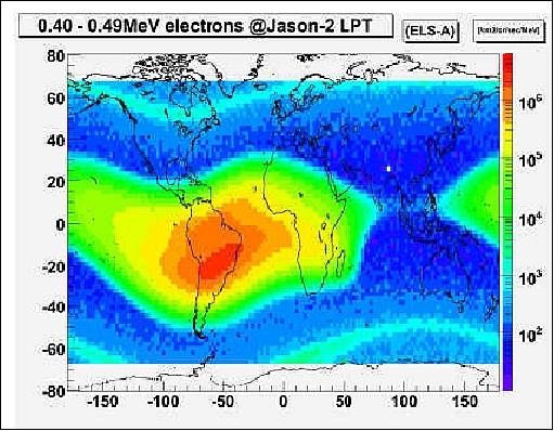
A world flux map for electrons measured by ELS-A in the 400 – 490 keV energy range is shown in Figure 27. The map shows averaged data for 4 months from November 2008 to February 2009. It is easily found that the border of SAA (South Atlantic Anomaly) at that altitude of 1336 km is extended from the middle of Indian Ocean to the western edge of Pacific Ocean. The slot region between the inner radiation belt and the outer radiation belt is also seen clearly.
The observational data of LPT helps to improve the radiation environment knowledge and characterize the local radiation environment to evaluate errors of other mission instruments. An improved LPT device will be also onboard JASON-3 which has the same orbit as JASON-2.
T2L2 (Time Transfer by Laser Link)
T2L2 refers to detectors for ultra-precise time transfer. The instrument is provided by the Riviera Observatory OCA (Observatoire de la Côte d'Azur) in Grasse, France, and by CNES. The T2L2 system on Jason-2 will allow the precise characterization of the USO (Ultra-Stable Oscillator) used by the DORIS positioning system. Relying on this clock, T2L2 may also permit to perform some orbit restitutions of Jason-2 uniquely by one-way laser ranging. 54) 55) 56) 57)
The main function of the T2L2 instrument is to allow comparison and follow-up of distant clocks, either of an embarked clock relative to a ground clock or of two (or more) ground clocks. The means used to establish a link between these clocks is the transmission and the dating of laser pulses. For this purpose the system is based on an embarked instrument connected to a clock and on a network of laser telemetry stations equipped with clocks.

The principle of this link is as follows: A ground station fires laser pulses to the satellite and records the local times of the firings. Aboard the satellite the T2L2 instrument composed of a detector and a dating system connected with the on-board clock, records the arrival dates of photons in the on-board reference time frame. A system of retro-reflectors reflects a certain ratio of the photons back towards the ground station, which, again, records the return dates in local time. Departure and return dates are measured in an accurate way with respect to the ground clock; arrival dates on the satellite are given to an arbitrary reference.
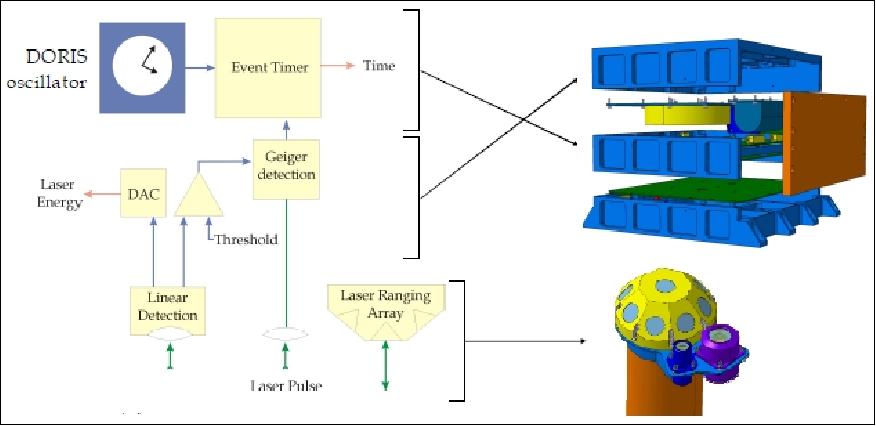
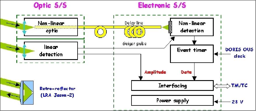
Legend to Figure 29: The photo detection unit includes two avalanche photo detectors: One in linear mode for energy measurement and trigger and the other in Geiger mode for precise chronometry.
The T2L2 satellite payload is composed of two subsystems (both subsystems are linked by electric connections and an optical fiber):
- The optical subsystem that insures the functions of electronic activation (linear detection) and collection of the laser pulse for the dating (non-linear optic). It constitutes an assembly of two small cases, one for each function.
- The electronic subsystem that insures the functions of non-linear detection, dating, instrument management and interfacing with the satellite. The set is assembled in a unique case.
The T2L2 tracking data are being collected by participating SLR stations on a global scale. The T2L2 Mission Center (CMT) processes and archives every pass and determines the corresponding time and frequency gaps for every SLR pass.
The T2L2 instrument is fully operational since June 30, 2008 and is working properly. The in-flight measurements are compliant with the instrument and system requirements (Ref. 38).
The T2L2 instrument has a mass of 8 kg (electronics unit) + 1.1 kg (optics unit). The power consumption is 42 W.
Thales-SESO (Société Européenne de Systèmes Optiques, Aix en Provence, France) was in charge of the design and realization of a demonstrator for a large and massive corner cube on Jason-2. This corner cube was foreseen to reflect the light coming from different (DORIS) laser stations located on ground. The operating mode was requesting a very wide angular field of view (> ±60°) and a unique component. This was possible to achieve only using a massive corner cube (i.e. not a hollow one) and cut from a very high index material (S-LAH65 in the present case). One of the main challenges for the mechanical mount was to design simultaneously: 58)
- a sufficiently light global assembly, as the mass of the optical cube only, with such glass and such optical material, was already important
- having sufficient stiffness to withstand environmental loads
- but also providing sufficient thermal dilatation possibilities (to avoid cube constraints) taking into account the very wide operating temperature range (-40°C to +40°C).
Performances of the Corner Cube:
• High index massive corner cube in order to procure a very wide angular retro reflection possibilities (i.e. at least ±60°) with a unique component
• Deviation accuracy: <2 arcsec
• Dihedral angle: <0,5 arcsec
• Size: Ø180 mm (corner to corner)
• Mounting: Aluminum Housing + flexible annular ring (attachment of cube with space qualified glue).
Ground Segment
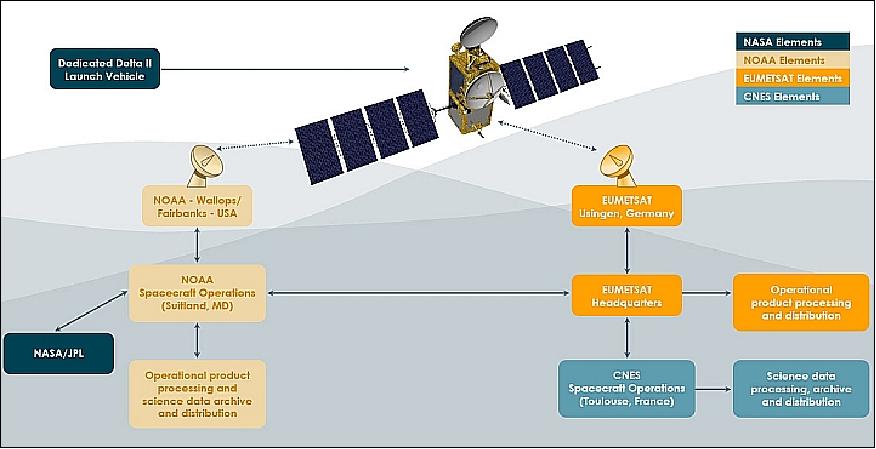
The Jason-2/OSTM ground segment is comprised of the integrated ground segment capabilities of NOAA, NASA, CNES and EUMETSAT - consisting of the control ground system and a mission ground system. 59) 60)
Control Ground System
- The Jason-2 Control Center is located at CNES in Toulouse, France. It monitors and controls the satellite during its entire mission life.
- All flight operations scheduling activities are allocated to SOCC (Satellite Operations Control Center) at NOAA. This includes command plan preparation, command transmission and telemetry acquisition and routing.
For command transmission and data acquisition, the CNES control center and the NOAA SOCC rely upon a ground terminal network of Earth terminal/stations suitably located to allow the required orbit coverage compliant with the data latency requirement. NOAA is providing its stations at Wallops Island, VA, and at Poker Flats, AK; EUMETSAT is providing its station in Usingen, Germany.
Mission Ground System
- CNES mission center: The mission center functions consist in instrument programming and monitoring (altimeter and Doris), commands requests generation (altimeter and Doris), mission management and operation plan definition, Precise Orbit Determination (POD), algorithm definition and POD data production and validation, scientific altimeter data processing and validation of altimetry product, data distribution and archiving.
- EUMETSAT and NOAA near real-time processing centers: The objective is to process and disseminate the near real-time altimeter product within 3 hours of data acquisition. In particular, EUMETSAT and NOAA will deliver OGDR (Operational Geophysical Data Record). The OGDR will be released within every three hours, containing surface wind speed and wave data and a first SSHA (Sea Surface Height Anomaly) estimate. To meet the timeliness requirements, the OGDR generation will be driven by telemetry availability and the SSHA will be based on the on-board computed DORIS ephemeris data. The OGDR will also be disseminated on the GTS [Global Telecommunications System (of the World Meteorological Organization (WMO)] and EUMETCast. 61)
The data of the three location systems, DORIS, TRSR-2 (GPSP), and LRA are being used in support of the POD (Precision Orbit Determination) function. In addition, three different data products are produced and distributed to the users: 62)
• The Operational Geophysical Data Record (OGDR) with a latency of 3-5 hours
• The Interim Geophysical Data Record (IGDR) with a latency of 1 -2 days
• The Geophysical Data Record (GDR) with a specified latency smaller than 60 days.
The GDR provides fully-validated data produced usually within five to six weeks of the events being recorded and covers sea surface height, principally for climate monitoring and climate modelling. The main users of this product are within the climate research community, for climate model verifications, for routine sea level station validation, and for the International Panel for Climate Change Assessment Report on rising sea levels. The orbits used for generating these products are generated by CNES and are called POE (Precise Orbit Ephemeris). They are computed using all three location systems: DORIS, GPSP, and LRA. They have an RMS orbit accuracy specification of 1.5 cm in the radial direction.
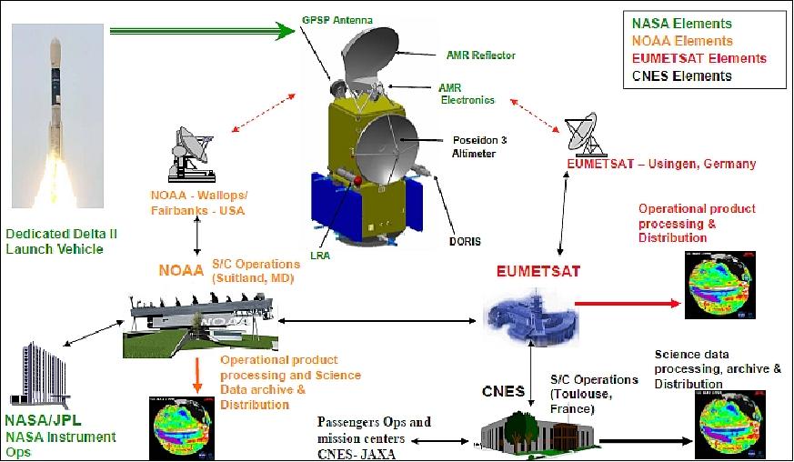
The general data flow for the Jason-2 ground system is shown in Figure 34. Raw telemetry data streams from the Jason platform are captured at NOAA’s Wallops and Fairbanks CDAS (Command and Data Acquisition Stations) and at EUMETSAT’s tracking station located at Usingen, Germany. These streams are then forwarded to other Jason-2 subsystems at NOAA’s SOCC (Satellite Operations Control Center), referenced as NOAA Spacecraft Operations in Figure 34) in Suitland, Maryland for further action.
A SOCC server functions as a centralized data exchange and distribution hub for data transfers between NOAA internal subsystems, and between NOAA and its partners. The ESPC (Environmental Satellite Processing Center), collocated with the SOCC in Suitland, generates near real-time operational data products using software provided by CNES. These products are made available to NASA/JPL, EUMETSAT and CNES via the centralized data server located at SOCC, and also staged to the ESPC primary data distribution server for dissemination to the general user community and to the NOAA long-term CLASS (Comprehensive Large Area Data Stewardship System) data archive. A similar process is followed at EUMETSAT for generation and delivery of operational data products to the partners. In addition, data products of improved accuracy are generated by CNES and distributed to NOAA and EUMETSAT in non-real-time fashion, usually with a latency of several days.
As shown in Figure34 , a bi-directional flow of data and information exists between the SOCC and EUMETSAT. The flow from SOCC to EUMETSAT includes the flow of Near-Real-Time operational products, stored payload telemetry, stored housekeeping and real-time housekeeping telemetry. The flow from EUMETSAT to SOCC includes spacecraft raw payload and housekeeping telemetry sent from the Usingen via the EUMETSAT communications network, offline (non-near real-time) geophysical data products generated by CNES, near real-time products generated by EUMETSAT, and earth station telemetry from Usingen.
References
1) E. Rodriguez, B. D. Pollard, “Centimetric Sea Surface Height Accuracy Using the Wide-Swath Ocean Altimeter,” Proceedings of IGARSS 2003, Toulouse, France, July 21-25, 2003
2) B. D. Pollard, E. Rodriguez, L. Veilleux, et al., “The Wide Swath Ocean Altimeter: Radar Interferometry for Global Ocean Mapping with Centimetric Accuracy,” Proceedings of the IEEE Aerospace Conference, Big Sky, MT, March 9-16, 2002
3) E. Rodriguez, B. D. Pollard, “The Measurement Capabilities of Wide-Swath Ocean Altimeters,” http://www.deos.tudelft.nl/gamble/docs/wsoa.pdf
4) P. B. de Selding, “Data Continuity May Be Affected By Delays in Jason-2 Development,” Space News, May 30, 2005, pp. 1 and 4
5) Y. Menard, L. Fu, F. Parisot, S. Kaki, A. Ratier, R. Cheney, “The Jason 2 Mission: Monitoring Ocean Surface Topography from Space,” Sept. 16, 2002, Presentation to EUMETSAT Scientific and Technical Group, http://ibis.grdl.noaa.gov/SAT/pubs/Jason2_paper.doc
6) “OSTM/Jason–2,” URL: http://sealevel.jpl.nasa.gov/files/ostm/Spacecraft-OSTM_Fact_Sheet_Final.pdf
7) G. Tavernier, “Jason-2: mission status, DORIS data delivery,” IDS Analysis Working Group Meeting, Paris, France,June 5-6, 2008, URL: http://ids-doris.org/documents
/report/AWG200806/IDSAWG0806_GTavernier_Jason2MissionStatus.pdf
8) “OSTM/Jason-2,” NASA/JPL, URL: http://sealevel.jpl.nasa.gov/missions/ostmjason2/
9) Steve Ciole, Esprit Smith, Pascale Bresson, Raphaël Sart, John Leslie, Neil Fletcher, Sean Potter, ”Ocean-Monitoring Satellite Mission Ends After 11 Successful Years,” NASA Press Release 19-079, 4 October 2019, URL: https://www.nasa.gov/press-release
/ocean-monitoring-satellite-mission-ends-after-11-successful-years
10) Alan Buis, ”Prolific Sea-Observing Satellite Turns 10,” NASA/JPL, 20 June 2018, URL: https://www.jpl.nasa.gov/news/news.php?release=2018-143
11) Alan Buis, ”Veteran Ocean Satellite to Assume Added Role,” NASA/JPL, June 30, 2017, URL: https://www.jpl.nasa.gov/news/news.php?release=2017-184
12) ”EUMETSAT extends Jason-2 operations and approves contracts for the deployment of EPS-Second Generation and the improvement of data access services,” EUMETSAT, 28 June 2017, URL: http://www.eumetsat.int/website/home/News/DAT_3536769.html?lang=EN&pState=1
13) ”EUMETSAT's 87th Session Results Include Extending Jason-2 Operations and Contracts to Deploy EPS' Second Gen System,” Satnews Daily, June 28, 2017, URL: http://www.satnews.com
/story.php?number=1801151497
14) ”El Niño: 1997-1998 vs. 2015-2016 — Will El Niño 2015-2016 flip to La Niña 2016-2017?,” NASA/JPL, January 5, 2017, URL: http://sealevel.jpl.nasa.gov/elnino2015/index.html
15) ”OSTM/Jason-2 has successfully completed its transfer to the interleaved orbit,” AVISO News, Oct. 17, 2016, URL: http://www.aviso.altimetry.fr/en/news/front-page-news/news-detail.html?
tx_ttnews%5Btt_news%5D=2037&cHash=b25642dcfcfb5e45d5c9a78ed67dfb49
16) ”Jason-2 to be moved to an interleaved orbit,” EUMETSAT, Sept. 22, 2016, URL: http://www.eumetsat.int/website/home/News/DAT_3212287.html?lang=EN&pState=1
17) ”El Niño: 1997 vs. 2015 — A Still-Growing El Niño Set to Bear Down on US,” NASA/JPL, Dec. 29, 2015, URL: http://sealevel.jpl.nasa.gov/elnino2015/index.html
18) Kasha Patel, Alan Buis, ”NASA Studying 2015 El Niño Event As Never Before,” NASA/JPL, News Release 2015-319, Oct. 19, 2015, URL: http://www.jpl.nasa.gov/news/news.php?feature=4740
19) “El Niño Conditions Are Growing Stronger,” NASA Earth Observatory, August 5, 2015, URL: http://earthobservatory.nasa.gov/IOTD/view.php?id=86341&src=eoa-iotd
20) Pascal Bonnefond, “Ocean Surface Topography Science Team Meeting,” The Earth Observer,” NASA, Volume 27, Issue 2, March-April 2015, pp: 41-45, URL: http://eospso.gsfc.nasa.gov/sites/default/files/eo_pdfs/Mar_Apr_2015_color_508.pdf
21) Peter B. de Selding, “Thales Alenia Space Nabs $94 Million Contract for U.S.-French Ocean Topography Satellite,” Space News, Jan. 6, 2015, URL: http://spacenews.com
/thales-alenia-space-nabs-94-million-contract-for-u-s-french-ocean-topography-satellite/
22) “Is El Niño Developing?,” NASA Earth Observatory, May 14, 2014, URL: http://earthobservatory.nasa.gov/IOTD/view.php?id=83653
23) Elizabeth Ritchie (Chair), Ana Barros, Robin Bell, Alexander Braun, Richard Houghton, B. Carol Johnson, Guosheng Liu, Johnny Luo, Jeff Morrill, Derek Posselt, Scott Powell, William Randel, Ted Strub, Douglas Vandemark, “NASA Earth Science Senior Review 2013,” June 14, 2013, URL: http://science.nasa.gov/media/medialibrary/2013/07/16/2013-NASA-ESSR-FINAL.pdf
24) “Jason-2 is Five Years Old,” NASA/JPL, June 21, 2013, URL: http://sealevel.jpl.nasa.gov/newsroom
/featurearchive/index.cfm?FuseAction=ShowNews&NewsID=435
25) Thierry Guinle, “Jason-2 Project Status,” OSTST (Ocean Surface Topography Science Team) 2012 meeting, Sept. 27, 2012, Venice, Italy, URL: http://www.aviso.oceanobs.com/fileadmin/documents
/OSTST/2012/oral/01_thursday_27/01_general/04_jason2_status_Guinle.pdf
26) “Happy 4th Anniversary OSTM/Jason-2,” NASA/JPL, June 19, 2012, URL: http://sealevel.jpl.nasa.gov/newsroom/featurearchive/index.cfm?FuseAction=ShowNews&NewsID=401
27) John Lillibridgea, Hans Bonekamp , Josh Willis, Pascal Bonnefond, “Preface, Marine Geodesy, Vol. 35, supp 1, 1-2, 2012
28) T. Guinle, “OSTM/Jason-2 Mission overview,” OSTM (Ocean Surface Topography Meeting), San Diego, CA, USA, Oct. 19-21, 2011, URL: http://www.aviso.oceanobs.com/fileadmin/documents/OSTST
/2011/oral/01_Wednesday/Plenary/Program%20Status/08%20OSTST_2011_
Jason-2_mission_overview_tg_v3.pdf
29) F. G. Lemoine, N. P. Zelensky, S. Melachroinos, D. S. Chinn, B. D. Beckley, D. D. Rowlands, S. B. Luthcke, “GSFC OSTM (Jason-2) Jason-1 & TOPEX POD Update,” OSTM (Ocean Surface Topography Meeting), San Diego, CA, USA, Oct. 19-21, 2011, URL: http://www.aviso.oceanobs.com/fileadmin/documents/OSTST/2011
/oral/02_Thursday/Splinter%203%20POD/03%20rev%20Lemoine_etal_SWT2011_v01.pdf
30) George Hurtt (Chair), Ana Barros, Richard Bevilacqua, Mark Bourassa, Jennifer Comstock, Peter Cornillon, Andrew Dessler, Gary Egbert, Hans-Peter Marshall, Richard Miller, Liz Ritchie, Phil Townsend, Susan Ustin,“NASA Earth Science Senior Review 2011,” June 30, 2011, URL: http://science.nasa.gov/media/medialibrary
/2011/07/22/2011-NASA-ESSR-v3-CY-CleanCopy_3x.pdf
31) Information provided by Walid Bannoura of NOAA, Suitland, MD, USA.
32) N. Picot, “Jason-2 -three years in orbit,” Aviso Special Issue, July 1, 2011, URL: http://www.aviso.oceanobs.com/fileadmin/documents
/newsstand/Newsletter/aviso_special_issue_3years_Jason2.pdf
33) “An Altimetry Milestone 3rd Anniversary OSTM/Jason-2 Completes Prime Mission,” NASA/JPL, June 16, 2011, URL: http://sealevel.jpl.nasa.gov/newsroom
/featurearchive/index.cfm?FuseAction=ShowNews&NewsID=379
34) Josh K. Willis, Lee-Lueng Fu, Eric Lindstrom, Margaret Srinivasan, “17 Years and Counting: Satellite Altimetry from Research to Operations,” Proceedings of IGARSS (IEEE International Geoscience and Remote Sensing Symposium) 2010, Honolulu, HI, USA, July 25-30, 2010
35) T. Guinle, /OSTM/Jason-2 Mission Overview,” 2010 OSTST (Ocean Surface Topography Science Team) meeting, Lisbon, Portugal, Oct. 18-20, 2010, URL: http://www.aviso.oceanobs.com/fileadmin/documents/OSTST/2010/oral/Guinle.pdf
36) G. Zaouche, J. Perbos, T. Lafon, V. Couderc, J. Lambin, J. D. Desjonqueres, C. Jayles, E. Jurado, P. Vaze, L. Fu, S. Brown, F. Parisot, H. Bonekamp, W. Bannoura, J. Lillibridge, “OSTM/Jason-2: Assessment of the System Performances (Ocean Surface Topography Mission: OSTM),” Marine Geodesy, Vol. 33, Supplement 1, 2010, pp. 26-52
37) G. Zaouche, “OSTM/Jason-2 Mission overview,” Proceedings of the OSTST (Ocean Surface Topography Science Team) 2009 meeting, Seattle WA, USA, June 22-24, 2009
38) G. Zaouche, “OSTM/Jason-2 Mission overview,” 2008 OSTST (Ocean Surface Topography Science Team Meeting) Meeting, Nice, France, Nov. 10-12, 2008
39) Josh K. Willis, “Early Results from the Jason-1/Jason-2 Tandem Mission,” Proceedings of the OSTST (Ocean Surface Topography Science Team) 2009 meeting, Seattle WA, USA, June 22-24, 2009
40) G. Tavernier, “Jason-2: mission status, DORIS data delivery,” IDS Analysis Working Group Meeting, Paris, France, June 5-6, 2008, URL: http://ids-doris.org/documents/report/AWG200806/IDSAWG0806_GTavernier_Jason2MissionStatus.pdf
41) “Mission /Program Status,” OSTST (Ocean Surface Topography Science Team) 2012 meeting presentations, Sept. 27, 2012, Venice, Italy, URL: http://www.aviso.oceanobs.com/fileadmin/documents
/OSTST/2012/oral/01_thursday_27/01_general/02_program_status_Parisot.pdf
42) “OSTM/Jason-2 Products Handbook,” August 3, 2009, URL: http://www.osdpd.noaa.gov/ml/ocean/J2_handbook_v1-4_no_rev.pdf
43) http://earth.eo.esa.int/brat/html/missions/jason2/instruments/welcome_en.html#doris
44) JPL's AMR Instrument on OSTM/Jason-2,” August 1, 2006, URL: http://sealevel.jpl.nasa.gov/newsroom/spotlights
/index.cfm?FuseAction=ShowNews&NewsID=304
45) http://www.nasa.gov/mission_pages/ostm/main/index.html
46) “International DORIS Service,” URL: http://ids-doris.org/
47) http://earth.eo.esa.int/brat/html/missions/jason2/instruments/doris_en.html
48) Flavien Mercier, Luca Cerri, Jean-Paul Berthias, “Jason-2 DORIS phase measurement processing ,” Advances in Space Research, Volume 45, Issue 12, 15 June 2010, pp. 1441-1454
49) B. Haines, W. Bertiger, S. Desai, Da Kuang, “Initial Orbit Determination Results for Jason-1: Towards a 1 cm Orbit,” ION-GPS 2002, Portland, OR, Sept. 24-27, 2002
50) F. Bezerra, E. Lorfevre, R. Ecoffet, D. Falguere, P. Bourdoux, “CARMEN/MEX test board for the study of radiation effects on electronic components aboard JASON-2 and SAC-D satellites ,” RADECS 2007 (Radiation and its Effects on Components and Systems 2007), Deauville, France, Sept. 10-14, 2007
51) “OSTM/Jason-2 Products Handbook,” January 20, 2009, URL: http://www.osdpd.noaa.gov/ml/ocean/J2_handbook_v1-3_no_rev.pdf
52) Tatsuto Komiyama, Haruhisa Matsumoto, Tateo Goka, Takahiro Obara, “JAXA/CNES Joint Radiation Experiment onboard Jason-2 Satellite,” Proceedings of the 27th ISTS (International Symposium on Space Technology and Science) , Tsukuba, Japan, July 5-12, 2009, paper: 2009-r-2-24
53) Osamu Okudaira, Haruhisa Matsumoto, Takahiro Obara, Tatsuto Komiyama, “Observation Result of Light Particle Telescope onboard JASON-2 Satellite,” Proceedings of the 28th ISTS (International Symposium on Space Technology and Science), Okinawa, Japan, June 5-12, 2011, paper: 2011-r-57
54) P. Exertier, O. Minazzoli, “T2L2/Jason2 : first results of ground to ground TTcampaigns in common view,” Proceedings of the GPhyS (Gravitation and Fundamental Physics in Space) Kick-Off Colloquium, Les Houches, France, Oct. 20-22, 2009, URL: http://gphys.obspm.fr/LesHouches2009/GPhyS1009/oct20/GPHYS_oct09_new_Exertier.pdf
55) Philippe Guillemot, Pierre Exertier, Etienne Samain, Francis Pierron, Jean-Marie Torre, Sylvie Leon, “Time Transfer by Laser Link: Results of the first year of operation,” 41st Annual Precise Time and Time Interval (PTTI) Meeting, Santa Ana Pueblo, NM, USA, Nov. 16-19, 2009, URL: http://www.dtic.mil/cgi-bin/GetTRDoc?AD=ADA518021
56) E. Samain, “T2L2 on Jason-2,” URL: http://cddis.gsfc.nasa.gov/lw15/docs/presents/Wednesday1615.pdf
57) https://t2l2.oca.eu/spip.php?article25
58) Denis Fappani, Déborah Dahan, Vincent Costes, Clément Luitot, “Thales SESO's hollow and massive corner cube solutions,” Proceedings of the ICSO (International Conference on Space Optics), Ajaccio, Corse, France, Oct. 9-12, 2012, paper: ICSO-054
59) “JASON-2 Ground Segment,” CNES, URL: http://missions-scientifiques.cnes.fr
/JASON2/GP_segment_sol.htm
60) “Jason-2 Ground Segment,” Aviso, URL: http://www.aviso.altimetry.fr/en
/missions/present-missions/jason-2/ground-segment.html
61) H. Bonekamp, F. Parisot, D. Klaes, “EUMETSAT and Operational Oceanography,” Symposium: 15 Years of Progress in Radar Altimetry, Venice, Italy, March 13-18, 2006
62) Y. Andrés, P.L. Righetti, C. Marquardt, “Near Real-Time Precise Orbit Determination for Radio Occultation and Altimetry Missions,” Proceedings of ION GNSS 2010, Portland, OR, USA, Sept. 21-24, 2010
The information compiled and edited in this article was provided by Herbert J. Kramer from his documentation of: ”Observation of the Earth and Its Environment: Survey of Missions and Sensors” (Springer Verlag) as well as many other sources after the publication of the 4th edition in 2002. - Comments and corrections to this article are always welcome for further updates (eoportal@symbios.space).
Spacecraft Launch Mission Status Sensor Complement Ground Segment References Back to top