ISS: Imagery from 2017 to 2016
Human Spaceflight
Related resources
ISS: Imagery in the Period 2017 to 2016
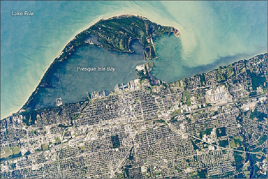
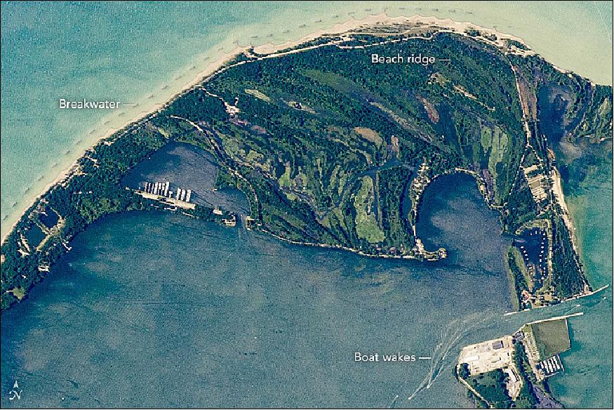
• December 23, 2017: An astronaut aboard the International Space Station focused a long-lens camera on the southern coastline of Lake Erie (Figure 1). The curved peninsula of Presque Isle State Park juts into the Great Lake, while the city in the lower part of the image is the deep-water port of Erie, Pennsylvania. Several V-shaped wakes show boat traffic around the port. 1)
- The lake water just offshore tends to be light-toned because significant river and beach sediment is regularly moved eastward by the action of wind and waves. The detailed image shows the swells made by these winds.
- Sediment has piled up to build this sand spit over thousands of years. Now covered with vegetation, Presque Isle State Park includes dozens of beach ridges—with each line representing a coastline from the past. The formation of the peninsula also has enclosed Presque Isle Bay, the site of modern port facilities.
- Because the sediment is constantly moved along the shore by waves, the exposed beach facing the lake has been protected from erosion. To do this, many short breakwaters (barriers) have been built just offshore for nearly the entire length of the beach.
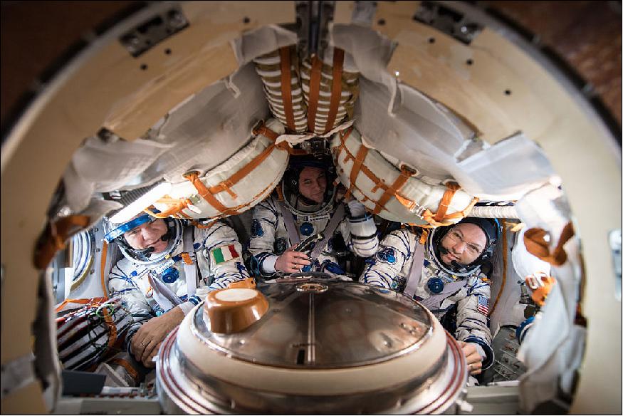
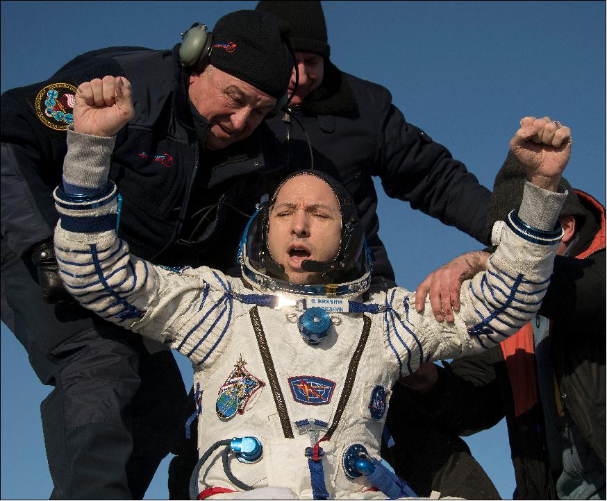
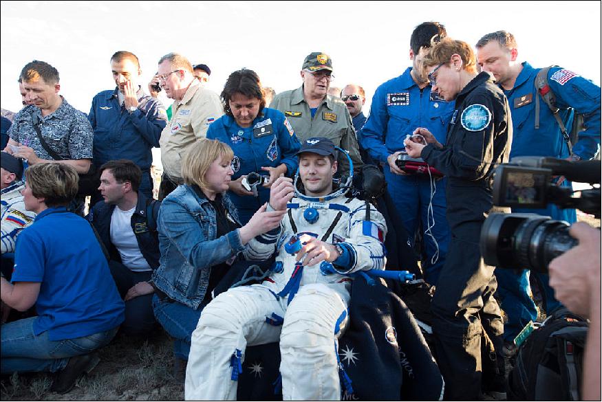
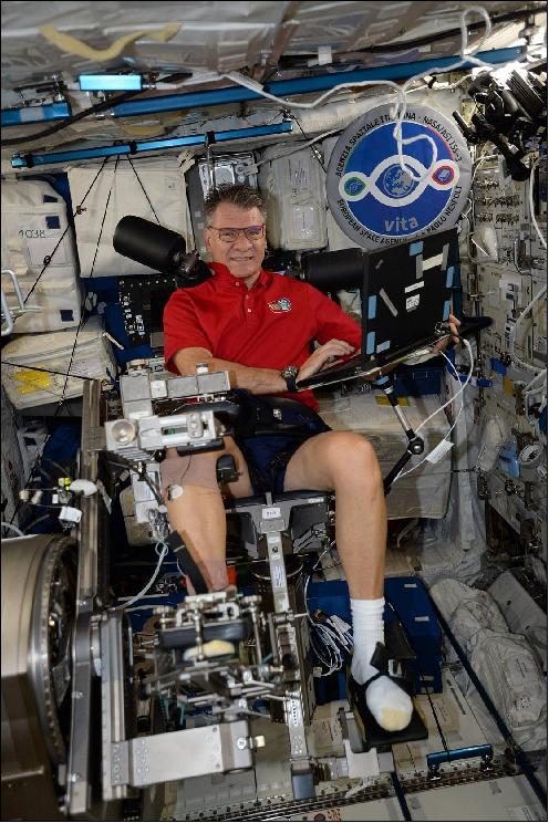
• December 14, 2017: ESA astronaut Paolo Nespoli and his colleagues Randy Bresnik (Expedition 53 commander) of NASA and Sergei Ryazansky of Roscosmos returned to Earth from the International Space Station on 14 December in their Soyuz MS-05 spacecraft landing at 08:37 GMT in Kazakhstan. 2) 3)
- The ride home from the International Space Station saw the trio brake from 28 800 km/h to a standstill at touchdown in barely three hours.
- Paolo completed more than 60 experiments during his Vita mission, which stands for Vitality, Innovation, Technology and Ability.
- Paolo's body was itself an arena for research: his eyes, headaches, sleeping patterns and eating habits were monitored to learn more about how humans adapt to life in space. Temperature recordings, muscle exercises and plenty of blood and saliva samples will add to the picture and prepare humans for missions further from Earth.
- During his time on the orbital complex, Bresnik ventured outside the confines of the space station for three spacewalks. Along with NASA astronauts Mark Vande Hei and Joe Acaba, Bresnik lead a trio of spacewalks to replace one of two latching end effectors on the station's robotic arm, Canadarm2. They also spent time lubricating the newly replaced Canadarm2 end effector and replacing cameras on the left side of the station's truss and the right side of the station's U.S. Destiny laboratory.
- Sergei Ryazansky of Roscosmos conducted one spacewalk with fellow cosmonaut Fyodor Yurchikhin in August to deploy several nanosatellites, collect research samples, and perform structural maintenance.
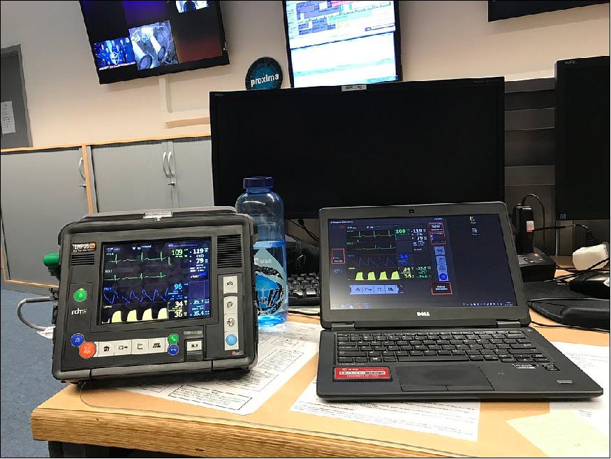
- Tempus Pro, a portable vital-signs monitor capable of telemedicine via satellite, is helping medics at ESA astronaut landings.5) On Sept. 29, 2017, Thomas Pesquet was the first to benefit following his Proxima mission.
- At Paolo Nespoli's landing a set of features of this device including the ultrasound probe, developed during the ESA Amazon project, were used under the harsh Kazakh winter conditions.
- Remote Diagnostic Technologies in the UK developed the Tempus device with funding and support from the Business Applications part of ESA's Advanced Research in Telecommunications Systems program.
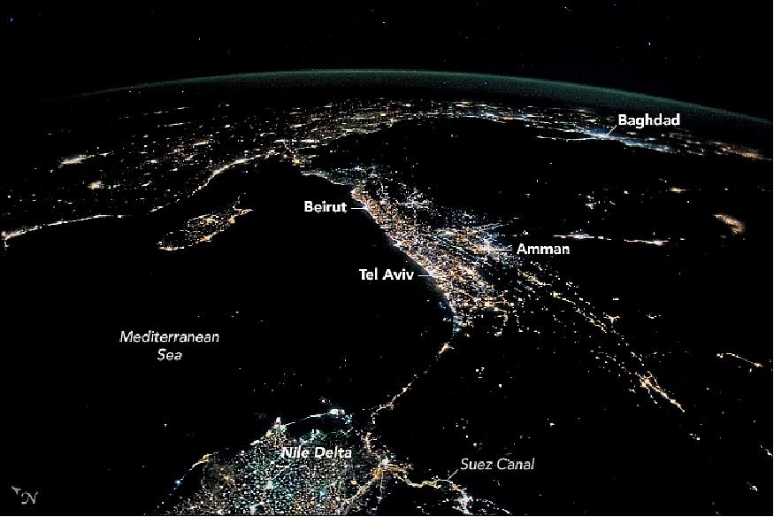
• December 11, 2017: This photograph of Figure 6, taken from the ISS (International Space Station), shows the sweep of the coastline of the eastern Mediterranean Sea. The cluster of lights at image center includes the major population centers of the Levant. The brightest lights are the cities of Tel Aviv in Israel, Amman in Jordan, and Beirut in Lebanon. Other light clusters include the Nile Delta in Egypt, and a nearby thin string of lights revealing the Suez Canal. The more scattered lights of the Turkish coastline and the country's mountainous interior arc from top left to top center. 6)
- Populations are small in the deserts of the Middle East, so few lights appear in vast portions of Saudi Arabia (right), Syria (top center) and Iraq (top right). The largest population centers cluster where water is available, especially along the great rivers of the region, the Tigris and Euphrates. In Iraq, the capital city Baghdad stands as the brightest spot where these rivers meet.
- Images such as this also show the hints of conflict. In Syria, darkness now reigns along a 300 km stretch where lights use to line the Euphrates River in the east of the country. This has left most of eastern Syria in the dark.
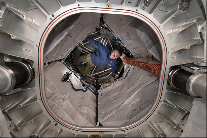
• December 5, 2017: ESA astronaut Paolo Nespoli completes some tests in the BEAM (Bigelow Expandable Activity Module) on the International Space Station (Figure 7). The crew routinely monitors the new expandable habitat for its suitability in space. The module was compressed for launch and expanded to its full volume in space, offering low-mass but larger constructions than traditional hulls. BEAM serves as an additional storage facility on the ISS, also used for crew operations. 7)
- As for beaming back to Earth, Paolo will rely on a Soyuz rather than a Scotty.
- Paolo and Expedition 52/53 crewmates Randy Bresnik of NASA and Sergei Ryazansky of Roscosmos will record a total of 139 days in space when they return to Earth on 14 December. They will hitch a ride back to Earth in Soyuz MS-05, landing on the Kazakh steppe in the early hours.
- By the end of his Vita mission, Paolo will have completed over 60 experiments covering biology, material sciences, technology, education and human research. During this time Paolo, Randy and Sergei also welcomed five visiting vehicles – a Soyuz crew vehicle and four cargo ferries – two of which Paolo captured with the 16 m-long Canadarm2 robotic arm.
- With the 139 days of Vita, Paolo totals 313 days in space across his three flights.
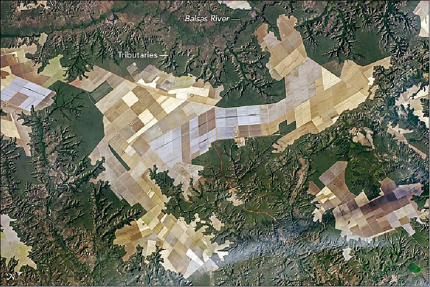
• December 4, 2017: An astronaut aboard the International Space Station focused a camera on the geometric patterns of farms on some plateaus in northeast Brazil. Here the fields, mainly soybeans and maize, have been planted right up to the edges of the small plateaus. The edges are ragged lines marked by cliffs (Figure 8). 8)
- The many flat plateau surfaces of southern Maranhão State are ideal for the wheeled machinery of mechanized agriculture. In fact, the capital city of the region, Balsas, is known as the "capital of mechanized agriculture."
- The steep-sided river valleys—such as that of the Balsas River—lie fully 200 meters below the plateaus. Numerous finger-like tributaries are eroding and creating smaller valleys, which are poor landscapes for mechanized farming. One result is that the forests around the valleys remain in their pristine form, even though southern Maranhão is part of Brazil's long "arc of deforestation" on the southern margin of a dense forest zone.
• November 16, 2017: Astronauts aboard the International Space Station are now busily unloading nearly four tons of science experiments, research gear, station equipment and crew supplies – following the launch of the Orbital ATK Antares rocket earlier this week on Sunday Nov. 12 from Virginia's eastern shore that propelled the Cygnus cargo freighter to an on time arrival two days later on Tuesday Nov. 14. The Orbital ATK Cygnus spacecraft was christened the S.S. Gene Cernan and named in honor of NASA's Apollo 17 lunar landing commander, Gene Cernan. 9)
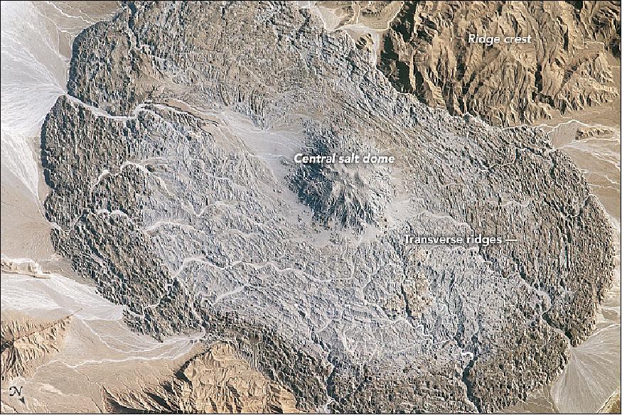
• November 13, 2017: The scale and form of many impressive features on Earth's surface can only be fully appreciated through an overhead view. The astronauts onboard the International Space Station may enjoy the best overhead view of all. 10)
- The Zagros Mountains of southeastern Iran are the location of numerous salt domes and salt glaciers, formed as a result of the depositional history and tectonic forces operating in the region. While many of these landscape features are named on maps, the salt glacier in this photograph remains unnamed on global maps and atlases (Figure 10).
- The vaguely hourglass (or bowtie) shaped morphology of the salt glacier is due to the central location of the salt dome, which formed within the central Zagros ridge crest (top and lower left). Salt extruded from the dome and then flowed downslope into the adjacent valleys. For a sense of scale, the distance across the salt glacier from northwest to southeast is approximately 14 km.
- Much like what happens in flowing ice glaciers, concentric transverse ridges have formed in the salt perpendicular to the flow direction. While bright salt materials are visible in stream beds incising the salt glacier, older surfaces—those farther from the central salt dome—appear dark, most likely due to windblown dust deposition over time or entrainment of sediments in the salt during flow.
• November 9, 2017: A Full Moon is a sight to behold on or off planet. ESA astronaut Paolo Nespoli didn't miss the chance to photograph this one. Taken from the International Space Station – its solar panels take up much of the frame – the Moon still manages to draw the eye (Figure 11). 11)
- After more than 40 years, the Moon is once again in the spotlight of space agencies worldwide, as a destination for both robotic missions and human explorers.
- Why now? Relying on the success of the International Space Station partnership, the space community sees the Moon as a springboard to continue human exploration of the Solar System, with Mars as the next goal.
- Moving away from one-shot orbital missions, bold ambitions foresee humans exploring the polar regions hand-in-hand with robots, in international cooperation and commercial participation.
- This return to the Moon envisages a series of human missions starting in the early 2020s that would see astronauts interact with robots on the surface from orbit. Robots will land first, paving the way for human explorers.
- Lunar rovers, telerobotics and hybrid surface power are some of the innovative approaches that are being developed to support these early missions.
• November 7, 2017: Life on Earth has a myriad of problems, but gravity isn't one of them – staying grounded means organisms can soak up the light and heat that enables growth. — It's no wonder that the free-floating environment of space stresses organisms, which survive only if they can adapt. Like humans, plants have proven their robustness in space. Now, thanks to the International Space Station, we know more on how they cope with weightlessness. 12)
- To understand how light and gravity affect plant growth, researchers from the US and Europe have grown more than 1700 thale cress seedlings in Europe's Columbus module.
- Germinated in prepacked cassettes and monitored by ground control, the seedlings were harvested after six days, frozen or preserved and returned to Earth for inspection.
- Researchers are now working with realtime images of the seeds as they grew and genetic and molecular analyses of the returned seedlings.
- What were they hoping to find? — On Earth, roots grow down into the soil, reaching for water and minerals. Weightless disrupts this natural route, altering cell growth unless the plant can overcome it.
- The results so far are pointing to some interesting conclusions. Obviously, seedlings in microgravity grew random roots but they still managed to grow. Plant genes known to overcome environmental stresses on Earth – heat, frost, salinity – kick into gear. Red light seems to help re-regulate cell growth interrupted by weightlessness.
- The most recent lettuce harvest on the Space Station shows plants can already mature in space. So why study the seedlings?
- In this case, knowledge of how plants overcome gravitational stress to mature into harvestable crops is growing power.
- The new results suggest gravity may not be the biggest obstacle to growing plants in space, which is good news for future Moon and Mars colonies. We won't make it far into space if we can't grow our own food along the way.
- Back on Earth, global climate change is affecting agriculture, and understanding how plants respond to stress and adapt at genetic and molecular levels means we can help to increase agricultural efficiency in general.
- It may be a while before space farm to space table becomes the next big thing, but the latest experiments have taken us one step closer.
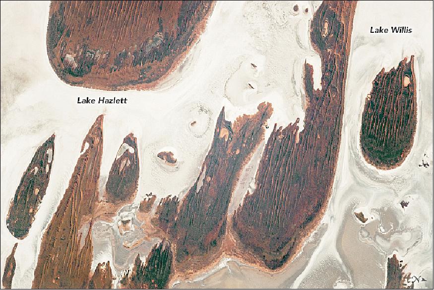
• October 30, 2017: Astronauts aboard the International Space Station photographed Lake Hazlett and Lake Willis in Western Australia's Great Sandy Desert (Figure 14). Hundreds of ephemeral salt lakes are peppered throughout the arid Australian Outback. When occasional flood waters pour into the lakebeds and then evaporate, they leave salt mineral deposits and create bright, expansive layers that are readily visible from space, as seen in this image taken by the Expedition 52 crew on the station. 13)
- The reddish-brown linear sand dunes are slightly higher in elevation (1.5 to 3 meters) and align with the general east to west wind flow in the region. Approximately 32 km south of the lakes lies Lake Mackay, the fourth largest salt lake in Australia. The Pintubi tribe and other Australian Aborigine survived around these lakes for thousands of years in what is now called the Kiwirrkurra Community.
• October 24, 2017: Astronauts have a wealth of knowledge to absorb before they can fly to the International Space Station: from piloting spacecraft to conducting spacewalks and maintaining one of the most advanced structures ever built by humans. -Having intricate knowledge of every component is impossible, so astronauts do regular refresher trainings while in space and ground control helps during complex operations. 14)
- Detailed checklists with step-by-step instructions are sent to the Space Station's computers for the astronauts to follow, but this has a large drawback: reading and clicking on to the next step in the instructions requires that the astronaut has to let go of any tools and divert attention to the detailed procedure list.
- ESA is working on the MobiPV mobile procedure viewer, which allows ground control to see what the astronauts sees and the wearer to work hands-free. MobiPV has been tested underwater and in space using commercially available parts but, just like mobile phones, the engineers are constantly upgrading the system to do more.
- Here, ESA astronaut Paolo Nespoli has set up the latest version of MobiPV to check the system is working as planned (Figure 15).
- This model allows multiple ground control stations to watch the video streamed from a camera in the glasses – useful for tasks that involve researchers and engineers from different countries as the International Space Station is run by USA, Japan, Russia, Canada and ESA.
- The download and upload speed has been improved, while the software was upgraded to allow for situations when there is no direct contact with ground control, preparing for missions further afield such as on the Moon or Mars.
- Unlike with mobile phones, any updates to MobiPV cannot cause unintended effects – performing any task in space allows no room for error. A lost connection or problem with the system cannot be allowed to impair the astronaut in any way, so MobiPV is robust.
- Paolo is set to use MobiPV to maintain a water pump in Europe's Columbus space laboratory.
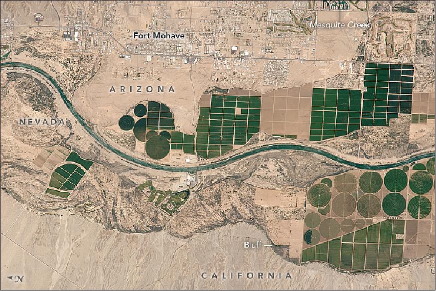
• October 23,2017: Looking down on the desert vistas of the southwestern United States, an astronaut took this photograph of a short section of the Colorado River. This reach of the river is marked by dark-toned agricultural fields, both rectangular and round, restricted to the narrow zone of arable land on the floodplain close to the river. For scale, the larger crop circles are 750 meters in diameter. Note that from the astronaut's perspective here, north is to the left. 15)
- The towns of Fort Mohave and Mesquite Creek are more difficult to see and occupy slightly higher ground—separated from the floodplain by steep bluffs that appear along the lower margin of the image. This area lies within the Fort Mohave Indian Reservation; it is also where the state boundaries of Arizona, Nevada, and California meet. The Mohave people have leased much of the reservation to agribusinesses for cultivation of commodity crops such as alfalfa, corn, and soybeans. This has led to an influx of non-native people, such that the Mohave now make up less than half of the population of the reservation.
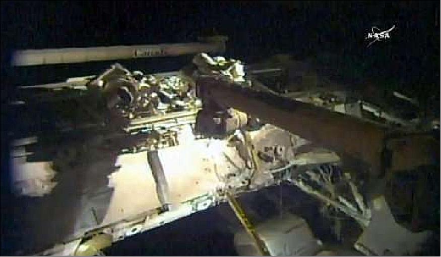
• On 20 October 2017, two NASA astronauts floated outside the International Space Station for the third spacewalk this month aimed at repairing the orbiting outpost's robotic arm and replacing old video cameras. During a six hour, 49 minute spacewalk, NASA's Joe Acaba and Randy Bresnik put the finishing touches on repairs to the 17 m long Canadarm 2. 16)
- Canadarm 2 has been a key piece of equipment at the orbiting outpost for 16 years, but in August it lost its ability to grip effectively.
- Astronauts inside the station maneuver the external arm to latch on to incoming spaceships that are packed with food and supplies for the rotating crew of six living in low-Earth orbit. It is also used to move equipment and people around outside the space station.
- The next US supply shipment, delivered on an unmanned Cygnus cargo ship launched by Orbital ATK, is expected to arrive November 13.
- In a rush to get the repairs done before then, NASA organized a rapid-fire succession of three spacewalks in three weeks — October 5, October 10 and October 20.
- During the October 20 outing, the astronauts replaced a poorly focusing camera system at the end of the robotic arm — necessary to get a good view of the approaching cargo ships — and fixed a fuse on the robotic arm's extension, called Dextre.
- They also installed another new high definition video camera outside the ISS.
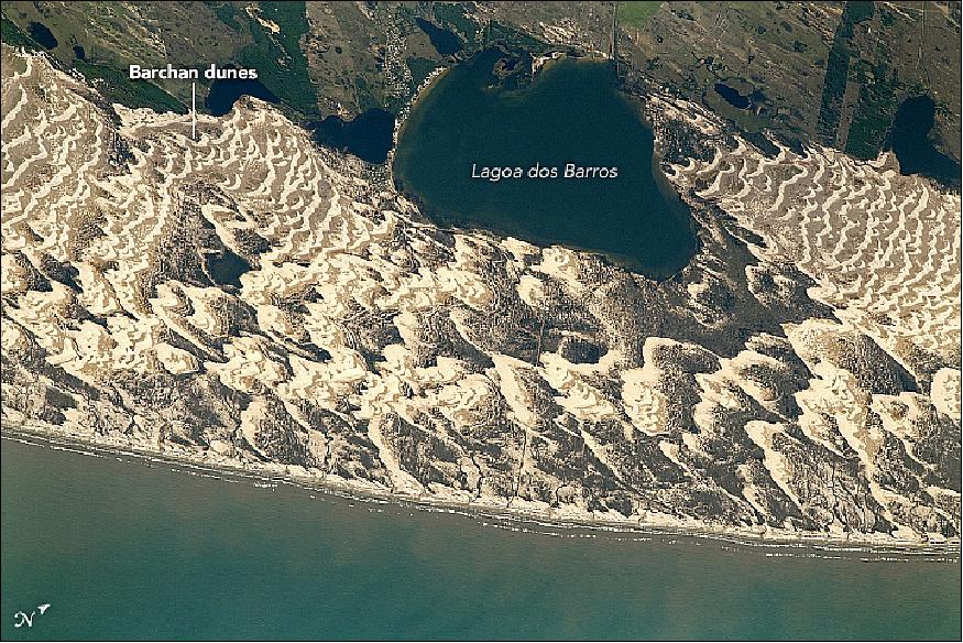
• October 16, 2017: An astronaut aboard the ISS captured this photograph of Lagoa dos Barros and crescent-shaped barchan dunes on the Atlantic coastline of southern Brazil. Lagoa dos Barros is approximately 4.5 km long. The lagoons along the Brazilian coast formed around 400,000 years ago as part of the cyclic rise and fall of sea level—known to geologists as the transgression-regression cycle. The formation of Lagoa dos Barros is similar to what occurred alongside Lagoa Mirim, 340 kilometers to the south-southwest. 18)
- Strong winds blowing in from the Western Atlantic sculpt the sand along the coast into distinctive crescent shapes. Multiple dunes have overlapped and coalesced to form dune fields, with prominent examples visible to the northeast and southwest of the lake. The tips of barchan dunes point downwind, indicating the prevailing wind direction. These fragile formations act as barriers keeping the wind and waves from penetrating inland, blunting the effect of storms and minimizing coastal erosion.
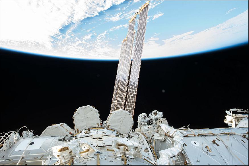
• October 10, 2017: Talk about an image making your head spin: ESA astronaut Paolo Nespoli took this stunning image of NASA astronauts Randy Bresnik and Mark Vande Hai during last week's spacewalk (Figure 19). 19)
- During this excursion, the duo replaced part of the Station's Canadarm2 robotic arm. The spacewalk took just under seven hours and saw the astronauts not only complete their main task but also accomplish some ‘get-ahead' tasks.
- Spacewalks are intensive for both crewmembers and ground support, so any opportunity to get ahead is welcomed.
- This is the first of three spacewalks planned this month. Randy and Mark will venture out again on 10 October, followed by Randy and NASA astronaut Joe Acaba on 20 October.
- The next spacewalks will again work on the robotic arm and replace some of the Station's cameras.
- Paolo will remain inside the Station and help the spacewalkers in and out of their suits. He will also be sure to take more stunning photographs.
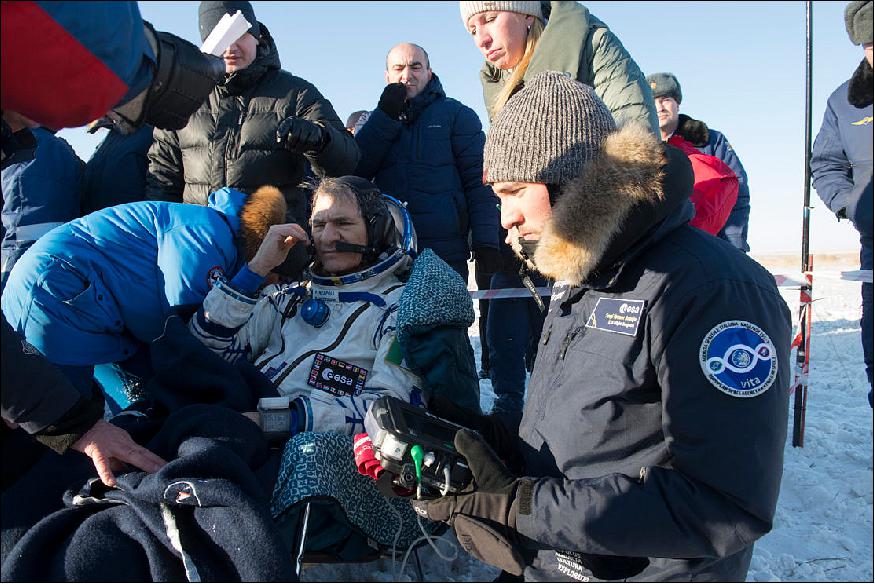
• September 29, 2017: Tempus Pro, a portable vital-signs monitor offering telemedicine via satellite, is helping medics at ESA astronaut landings. Thomas Pesquet was the first to benefit at the end of his mission in May. Remote Diagnostic Technologies in the UK developed the Tempus device with funding and support from the Business Applications part of ESA's Advanced Research in Telecommunications Systems program.
- Astronauts returning from space must readjust to life on Earth. Gravity influences the body's balance, cardiovascular functions, and especially the muscles, so astronauts are carefully monitored as soon as they are out of their reentry capsule.
- As he was feeling gravity for the first time in six months, several sensors were attached to his body and connected to the device to gather important medical information.
- This was repeated in the medical tent, during the helicopter ride back to Karaganda in Kazakhstan and on the aircraft back to Cologne in Germany, to allow doctors to detect any changes in his condition.
- "In the challenging environment of an astronaut landing, Tempus Pro allowed us to track and log medical information quickly and easily and to share this in real time with our medical colleagues at ESA's European Astronaut Center in Cologne," commented Sergi Vaquer, ESA's flight surgeon. - The secured satellite link with the astronaut center required a portable satellite antenna connected to the unit.
- All data were recorded in his encrypted patient record on the device and sent from Kazakhstan via a secured satellite link to the rest of the medical team at the European Astronaut Center in Cologne.
- Tempus Pro is compatible with all conventional instruments typically used for emergency monitoring and intensive care such as blood oxygen saturation and contact temperature sensors, electrocardiogram leads, laryngoscope and a USB ultrasound probe. It includes a GPS chip and has wi-fi, Bluetooth, GPRS (General Packet Radio Service) and Ethernet connectivity, and can exchange voice, video and medical data.
• During the week of 25-29 September 2017, the space community has gathered in Adelaide, Australia for the 68th IAC (International Astronautical Congress), the largest yearly event of the space community. At this conference, astronauts, researchers, space agencies and industry are discussing the latest in space exploration, including human and robotic villages on the Moon and Mars. - While scientific discoveries are important, the increasing role of business is a major theme of discussions. 20)
- ESA Director General Jan Woerner joined counterparts from Russian, American, Japanese, Canadian, Chinese and Indian space agencies in a plenary session to present ESA's plans to increase scientific research via new business opportunities.
- ESA has already taken the first steps in exploration innovation: last week, commercial enterprises were invited to submit proposals for technology, landers and payloads to help shape humanity's sustainable return to the Moon.
- A demonstrator mission is just one of ESA's ambitious plans for the next decade of exploration to take us from the Space Station to the Moon, a deep-space gateway and a Mars landing.
- This new age of exploration will be achieved not in competition, but through international cooperation. ESA is already working with partners globally to achieve its exciting vision of human and robotic exploration.
- While ESA targets deep space, the agency is still investing in LEO (Low Earth Orbit) facilities like the International Space Station. ESA will continue to support the Station to the end of its life in 2024 because it offers out-of-this-world facilities for science as well as stunning photographs such as this one taken by ESA astronaut Samantha Cristoforetti in 2015 (Figure 22).
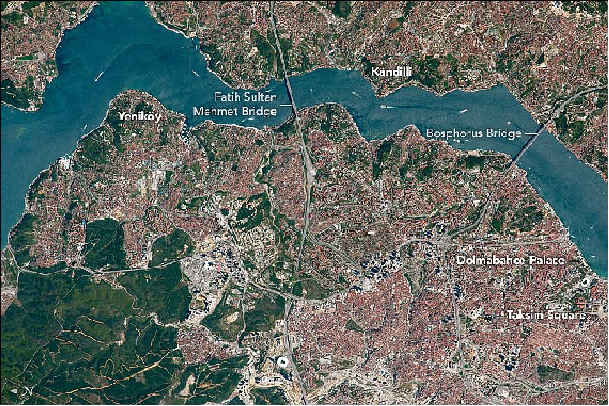
• September 25, 2017: An astronaut aboard the International Space Station (ISS) focused a camera on the Bosphorus (or Bosporus), also called the Istanbul Strait, which famously divides Europe (lower half of the image) from Asia (upper). Turkey's largest city, Istanbul, flanks both shorelines (Figure 23). 21)
- Forested parks (lower left) contrast with the red roof tiles of the cityscape, one of the most striking features of Istanbul when viewed from space. Three bridges connect the opposite shores, two of which appear in the image—the Bosphorus Bridge and the Fatih Sultan Mehmet Bridge, which is named for Mehmed the Conqueror.
- Highways lace the city, connecting clusters of high-rise buildings that stand out from the tiled roofs and cast more shadow than shorter buildings. Taksim Square is the center of modern Istanbul. It appears as an open space near the Dolmabahce Palace, the administrative heart of the Ottoman Empire in pre-republic centuries.
- The Bosphorus enables significant amounts of international shipping to move between the Mediterranean Sea and the Black Sea. It is especially important as an outlet for Russian oil products.
- In this photograph, a few ships are visible in the waterway. At several points they need to make dangerously sharp turns, with coastlines obstructing visibility. This is especially true at Yeniköy and Kandilli Point. Navigation is made more hazardous because currents can reach 7 to 8 knots (3.6 to 4.1 m/s). The risks of navigating the Bosphorus are multiplied by the heavy ferry traffic linking the European and Asian shores.
- To reduce the number of ships and to improve safety in this narrow waterway—just 1050 m at the Bosphorus Bridge—officials have proposed to dig a new waterway. The Kanal Istanbul would connect the Mediterranean and Black Sea at a point 70 km to the west of Istanbul.
• September 1, 2017: This weekend ESA astronaut Paolo Nespoli will say farewell to three of his crewmates who will leave the International Space Station back for Earth. 22)
- Fyodor is the current commander of the Space Station so he will hand over duties to NASA astronaut Randy Bresnik on Friday, 1 September at 20:30 CEST (Central European Standard Time) in a formal ceremony that will be broadcast live via NASA television. This ceremony will mark the end of Expedition 52.
- The flight home for the trio will leave late at night European time with Peggy, Fyodor and Jack saying goodbye at 20:00 CEST and closing the hatch between Soyuz MS-04 and the Space Station at around 20:40 CEST. The spacecraft is scheduled to undock around midnight CEST with landing at 3:22 CEST on Sunday morning.
- Paolo will stay in space with Randy and Roscosmos astronaut Sergei Ryazansky looking after the Space Station and continuing their science duties.
- The next trio to visit are already gearing up for launch on 12 September. NASA astronauts Mark Vande Hei and Joe Acaba will join Russian commander Alexander Misurkin in their Soyuz MS-06 spacecraft.
- Peggy Whitson returned to Earth on September 3, 2017 after she accrued a total of 665 days in space over the course of her career. This total was more time in space than any other woman worldwide and any other American of any gender.
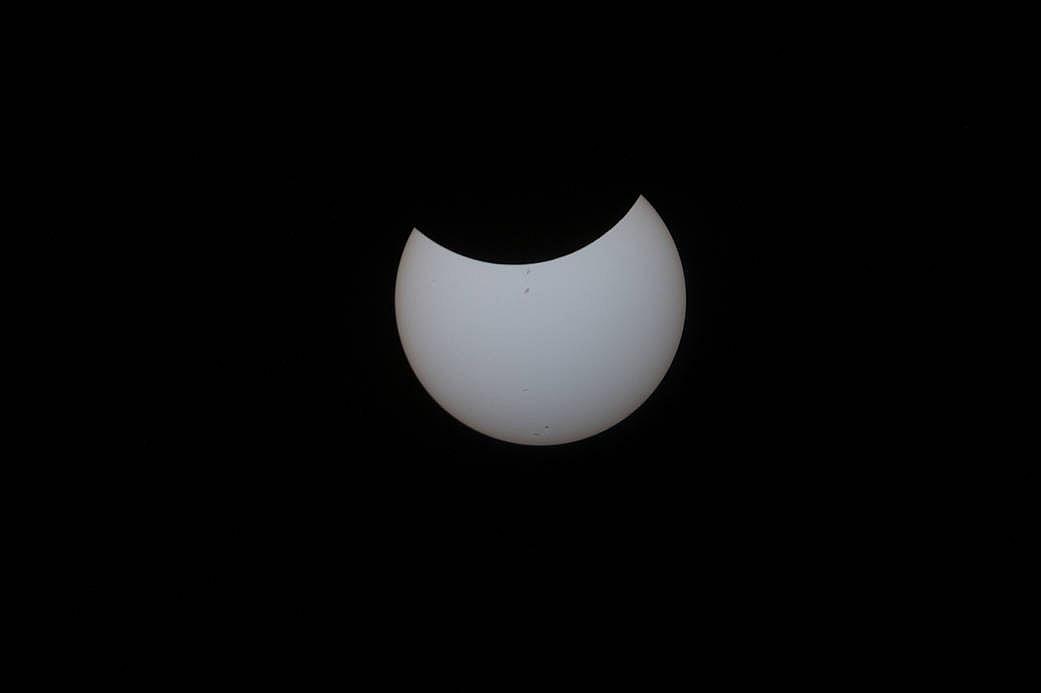
• August 22, 2017: Aboard the International Space Station, NASA Flight Engineer Randy Bresnik took still images of the partial solar eclipse as seen from the unique vantage of the Expedition 52 crew on August 21. Witnessing the eclipse from orbit with Bresnik were NASA's Jack Fischer and Peggy Whitson, ESA (European Space Agency's) Paolo Nespoli, and Roscosmos' Commander Fyodor Yurchikhin and Sergey Ryazanskiy. The space station crossed the path of the eclipse three times as it orbited above the continental United States at an altitude of 400 km. 23)
- On August 21, 2017, the Earth crossed the shadow of the moon, creating a total solar eclipse. Eclipses happen about every six months, but this one is special. For the first time in almost 40 years, the path of the moon's shadow passed through the continental United States.
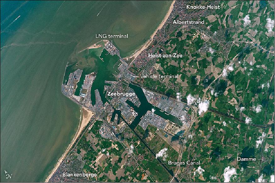
• August 21,2017: Looking down on the narrow seas between Europe and England, an astronaut took this photograph of the small town of Zeebrugge, one of Europe's most important modern ports (Figure 27). This Belgian town has just 4,000 inhabitants, but it takes 11,000 people to operate the port, so workers stream in from neighboring coastal towns such as Knokke-Heist, Heist-aan-Zee, and Blankenberge. 25)
- Zeebrugge is a town of superlatives. It is the world's largest port for the import and export of new vehicles, with more than 1.6 million handled in 2010. Zeebrugge is also the site of Europe's largest LNG (Liquid Natural Gas) terminal, receiving the gas via an undersea pipeline from the North Sea.
- The port at Zeebrugge accommodates "ultra-large" container ships, so it is one of the most important European hubs for containerized cargo. The most important function of the port is intense "RoRo traffic" (roll-on roll-off) between cities on the Continent, Great Britain, Scandinavia, and Southern Europe. The port handles more than 2.5 million standard containers,TEUs (Twenty-foot Equivalent Units) and 50 million tons of cargo each year.
- Being close to the United Kingdom, the coastal town also functions as a passenger ferry terminal. It attracts tourists to its cruise ships as well as its beaches, which are well developed north of the harbor in Albertstrand. Zeebrugge is also Belgium's most important fishing port, and its wholesale fish market is one of the largest in Europe.
- Hundreds of years ago, an arm of the sea extended well inland as far as the village of Damme, which acted as a port for centuries. When this inlet silted up, Zeebrugge became the port for the famous historical inland city of Bruges (just outside the lower right of the photo) with which it is still connected by a straight canal. Zeebrugge means Bruges by the sea.
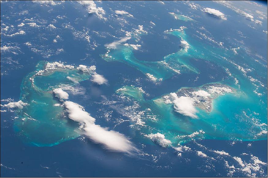
• Aug. 16, 2017: One of the most recognizable points on the Earth for astronauts to photograph is the Bahamas, captured in striking images many times from the vantage point of the International Space Station. Expedition 52 Flight Engineer Randy Bresnik of NASA took this photo on Aug. 13, 2017, and shared it with his followers on social media (Figure 28). Bresnik said, "The stunning Bahamas were a real treat for us. The vivid turquoise of the water over the reef was absolutely captivating." 26)
• August 3, 2017: The newest crewmember on the International Space Station, ESA astronaut Paolo Nespoli, has hit the ground running. After arriving in the early hours of 29 July and taking the rest of the day off, Paolo and the crew were back to work by 30 July. 27)
- First up on Paolo's schedule is a human physiology experiment using the Mares (Muscle Atrophy Research and Exercise System). MARES, housed in Europe's Columbus laboratory module, is a three-in-one muscle-measuring machine that monitors astronauts' muscles as they work out. - Muscle strength decreases during spaceflight and researchers need to know why in order to prepare for long missions and safe space tourism.
- The measurements are part of the Sarcolab-3 experiment that is assessing how weightlessness affects the calf and ankle muscles, the parts of the leg that carry the load of the rest of the body. "This is important, as establishing the mechanisms involved in space-related muscle deterioration will help us to devise optimized countermeasures," says Thu Jennifer Ngo-Anh, head of ESA's Human Research Office.
- Sarcolab-3 is a unique experiment, involving scientists from NASA, ESA and the Russian Institute of Biomedical Problems – an example of international cooperation benefitting scientific research.
• July 31, 2017: An astronaut aboard the International Space Station shot this photograph of Crater Lake, in the Cascade Mountains of southwest Oregon. Snow still blankets most of the slopes surrounding the crater in late June, and clouds cast dark shadows on the lake surface. Wizard Island, a cinder cone volcano, is almost hidden by the clouds over the western part of the lake (Note that north is to the bottom of the photo). 28)
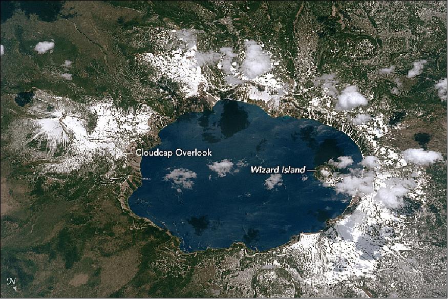
- Crater Lake is the surface expression of a caldera that formed when Mount Mazama—a composite volcano whose peak once towered 3,600 meters above sea level—exploded and collapsed in a catastrophic eruption approximately 6,000 to 8,000 years ago. The lake now stands 1,883 meters above sea level.
- Fed by rain and snow, and with no rivers flowing in or out, Crater Lake is the deepest in the United States and ninth deepest in the world. The depth of the lake (592 m) was first calculated by geologist Clarence Dutton and his team using 168 measurements made with piano wire and lead weights. He was assisted by William Steel, who later campaigned to establish Crater Lake as a national park in the late 1800s. The original measurement of depth was only 53 feet off from modern sonar measurements.
- The lake is 8.0 by 9.7 km across, with a caldera rim ranging in elevation from 2,100 to 2,400 m and an average lake depth of 350 m. The lake's maximum depth has been measured 594 m which fluctuates slightly as the weather changes.
- In 1902, Crater Lake and the surrounding 740 km2 were established as Crater Lake National Park. In 2016, more than 750,000 people visited the park. Part of the reason the lake has so many visitors is the fishing. In the late 1800s, Steel and colleagues introduced six species into the lake, though there are only rainbow trout and Kokanee salmon (the landlocked version of sockeye salmon) remaining today. Since none of them were native to the lake, fishermen are not required to obtain a permit.
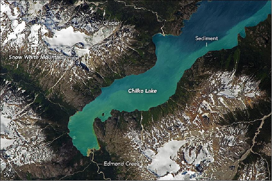
• July 17, 2017: Astronauts aboard the ISS (International Space Station) took this photograph of the south end of Chilko Lake in the Coast Mountains of British Columbia (Figure 31). Seen here are the southern 11 km of the lake (with a total length of 65 km, a surface area of 184 km2 and a water volume of 21.2 km3). The lake surface lies at 1,175 m in elevation, with neighboring mountains reaching so high (more than 2,200 m) that they support permanent ice fields and glaciers. 29)
- Occupying a valley carved by glaciers, the remote lake dominates Ts'yl-os Provincial Park (pronounced "sigh-loss"). The lake, 250 km north of Vancouver, is the largest natural high-elevation lake in Canada. The park is administered as the traditional territory of the Xeni Gwet'in people, one of the First Nations of British Columbia. The park is also named Ts'il-os in the Athabaskan Chilcotin (Tsilhqot'in) language. Ts'il-os is also the Tsilhqot'in name for Mount Tatlow 3,063 m, which stands in the ranges between the Chilko and Taseko Lakes.
- Edmond Creek has built a small delta at the head of the lake. Its glacial meltwater feeds fine white sediment (glacial flour) into the lake, changing its color. Most of the lake appears a deep blue color because of its depth (366 meters), but the glacial flour lightens the water color near the delta. The pattern of light-colored water hugging the southeastern shoreline shows that currents in the lake flow counter-clockwise and draw the muddy water northward. The currents are driven by the dominant westerly winds in this region of Canada.
- Seen from space, the extreme topography of the Canadian Coast Mountains creates a distinctive contrast between snowpack and ice on high peaks, such as Snow White Mountain, and dark valleys nearby. The valleys are dominated by forests and are often in shadow, partly because of the low sun angle at this latitude (51°16'N 124°3'W). Some north-facing slopes never receive direct sunlight.
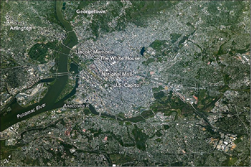
• July 10, 2017: An astronaut aboard the International Space Station took this photograph (5 m spatial resolution) of Washington D.C., the capital of the United States of America (Figure 32). Here the Potomac River flows south toward Chesapeake Bay and forms the geographic boundary between Virginia and Washington (as well as Maryland), while the Anacostia River links to the Potomac on the eastern side of the city. 30)
- Wedged between Maryland and Virginia, the District of Columbia was established in 1790 to serve as the permanent seat of the U.S. federal government. Originally the territory was relinquished by Virginia and Maryland as a 100-square-mile plot (259 km2) on both sides of the Potomac River. At the time, Georgetown, Maryland, and Alexandria, Virginia (just out of the scene to the lower left), were successful ports located on the eastern and western sides of the river. Georgetown remains as an historic neighborhood of Washington, D.C. In 1846, Virginia gained back the land contributed to the District of Columbia as a result of neglect of the area by Congress (known as retrocession). Those areas eventually became the cities of Arlington and Alexandria. There are 40 boundary stones that mark the original District boundary and stand as the oldest federal monument in the country.
- The past 200 years have painted Washington rich with social and political history. Hundreds of monuments and sculptures are peppered throughout the city to honor the nation's founders, its presidents, its military and cultural heroes, and other men and women who have shaped the nation. Among the most popular places are the Lincoln Memorial, the National Mall, the White House, and the United States Capitol.
- According to the US Census Bureau, more than 681,000 people reside in Washington. Commuters from Virginia and Maryland swell the daytime, work-week population past one million.
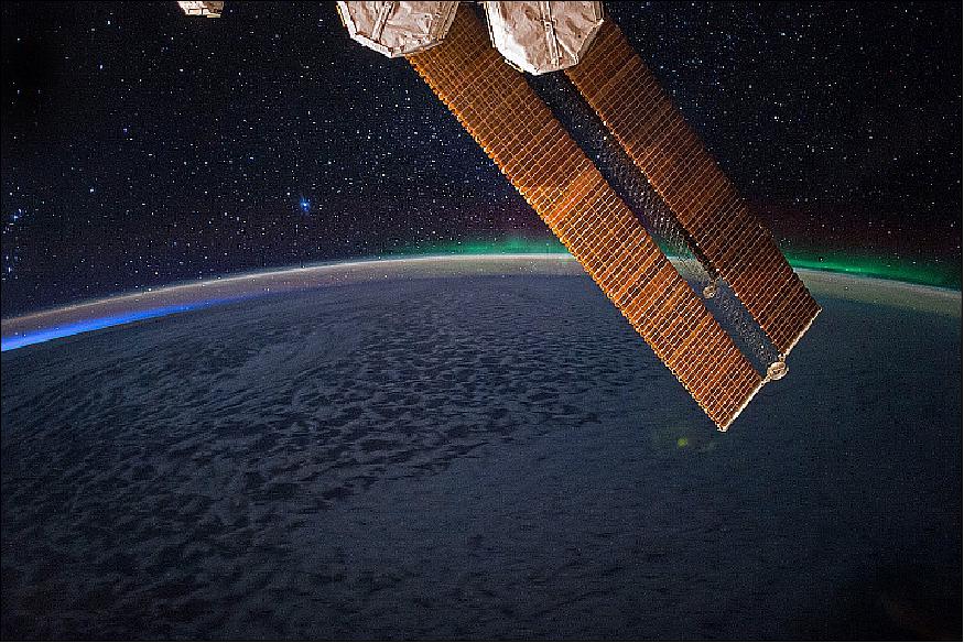
• July 2, 2017: While passing over the Great Australian Bight and the cloud-covered Indian Ocean, NASA astronaut Jack Fischer looked south from the International Space Station and photographed the glowing green lights of the aurora australis. The blue glow of dawn appears at the far left, the ISS solar arrays jut into the foreground, and stars fill the space above the edge of the atmosphere. 31)
- The aurora australis (southern lights) occurs when charged particles from the magnetosphere (the magnetic space around Earth) are accelerated by the solar wind or storms from the Sun. The pressure and magnetic energy of solar plasma stretches and twists the magnetic field, particularly on the night side of Earth. This energizes particles trapped in our magnetic field, and that energy is released suddenly as the field lines snap the particles down field lines toward the north and south magnetic poles.
- These fast-moving electrons collide with Earth's upper atmosphere, transferring their energy to oxygen and nitrogen molecules and making them chemically "excited." As the gases return to their normal state, they emit photons—small bursts of energy in the form of light. The color of light reflects the type of molecules releasing it; oxygen molecules and atoms tend to glow green, white, or red, while nitrogen tends to be blue or purple. This ghostly light originates at altitudes of 100 to 400 km.
- The fainter arc of light that parallels the horizon—airglow—is another manifestation of the interaction of the Earth's atmosphere with radiation from the Sun.
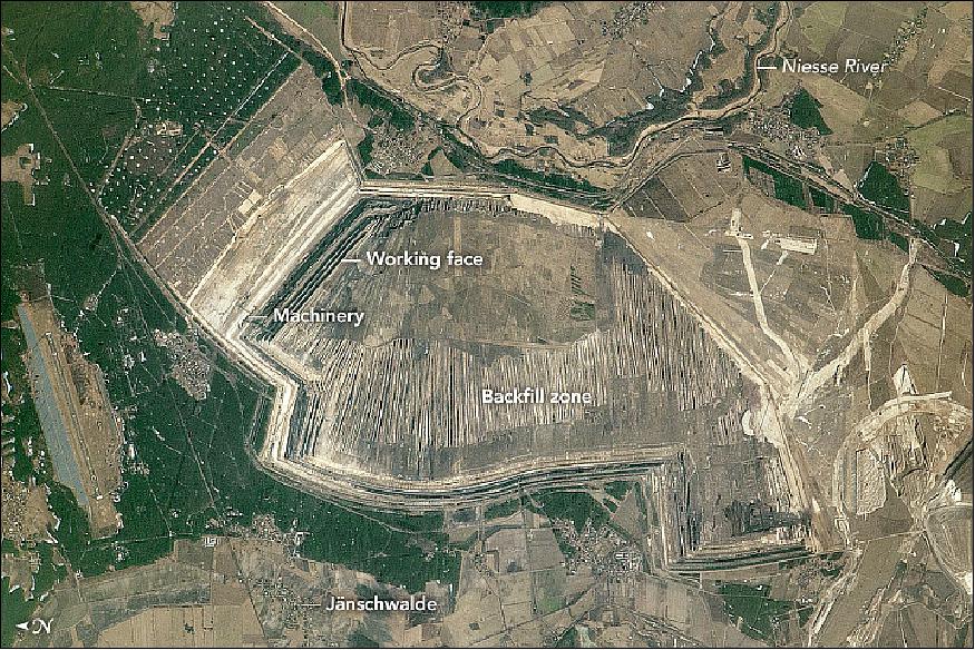
• June 26, 2017: An astronaut on the International Space Station took this photograph of a strip mine in Germany (Figure 34), located along the Polish border at the Neisse River (Nysa in Polish). Here lignite, also known as soft brown coal, is being mined in large quantities to supply one of Germany's largest power stations near the village of Jänschwalde. 32)
- Using a long lens, the astronaut managed to capture the size and detail of the artificial landscape that results from strip mining. The rock face that is being actively worked casts a series of straight, dark shadows. Another strip mine is active immediately south (lower right).
- Immense excavator machines rip up the lignite; these can be seen at the west end of the face in the high-resolution download of the image. At this mine, the machines scrape off the overlying non-fuel rock layer (known as overburden), dig up the lignite, and then replace the mined strip with the overburden material as the rockface advances. This reclaimed "backfill zone" appears in the image as a series of lines parallel to the mining front, but lacking the shadow.
- Jänschwalde power station (just outside the bottom of the photo) is the third largest in Germany, with yearly power output of 22 billion kilowatt hours. At peak production it requires 80,000 tons of lignite fuel daily. Lignite is only economically mined if it lies near the surface and spread over a wide area. The area set aside for this mine is greater than 30 km2.
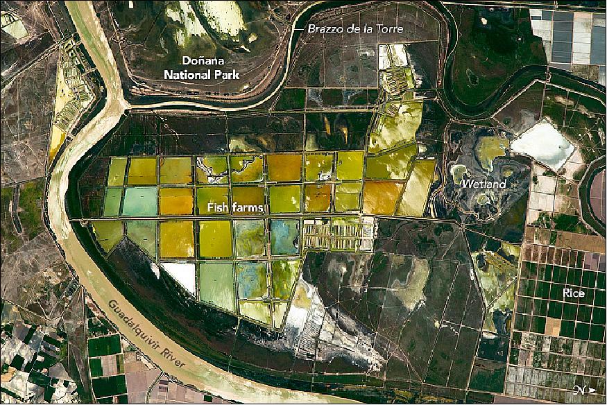
• June 19, 2017: An astronaut took this photograph of a section of Isla Mayor, an island in the delta of the Guadalquivir River in southwestern Spain (Figure 35). The Doñana National Park is a marshland nature reserve that has been proclaimed a UNESCO World Heritage site. The larger, multi-colored geometric shapes in the scene are fish ponds, while the smaller, dark rectangles are rice fields. 33)
- The fish farming practiced here tries to mimic natural conditions—maintaining the original wetland conditions—more closely than many "intensive" fish farms around the world. These larger ponds are fed with river water, which contains natural food types, especially algae and shrimp, without commercial fish feed or antibiotics. Such larger fish ponds reduce problems, such as fish diseases and degradation of the pond water, and raise marketability. Species farmed here include sea bass, grey mullet, meagre, and shrimp.
- Cattle raising and rice farming are being progressively phased out of the area as part of a wider plan to surround the Doñana park with environments that resemble the original wetlands. The region is becoming one of the largest bird refuges in Europe, attracting almost 250 species of migratory birds each year. Fish taken from the ponds by birds—amounting to about 20 percent of the fish population—are viewed as part of an ecosystem in balance.
• June 15,2017: Space is an inhospitable environment for the human body but we adapt remarkably well. Within hours, the brain adjusts to the lack of an up or down, as if floating is all it has ever known. Now researchers are learning how our internal clock similarly adjusts to the restrictions of space. An ESA-sponsored experiment has found that while you can take the body out of Earth, you can't take an Earth-based rhythm out of the body. 34)
- At the core: Circadian rhythms describe the changes our bodies undergo over about 24 hours. This internal clock is regulated by core temperature, which tells our bodies when its day or night and triggers systems such as metabolism and the sleep cycle.
- On Earth, our core temperature is a steady 37°C, with half a degree decrease in the early morning and increase in the early evening.
- "If our bodies are an orchestra, core body temperature is the conductor, signalling when hormones and other systemic functions should come into play," explains Dr. Hanns-Christian Gunga of the University of Berlin, principle investigator of the experiment.
- The circadian rhythm is a smooth wave that synchronizes with our day of 24 hours. — What happens to this wave in space? Researchers predicted that the lack of regular sunlight and the artificial environment of the ISS (International Space Station) would flatten it. In other words, core temperature would drop and the human body would lose its rhythm.
- To test this theory, 10 astronauts measured their core temperatures for 36 hour periods before, during and after spaceflight using two sensors strapped to the forehead and the chest.
- The results so far have amazed researchers. Core body temperature increased overall, and the half-degree fluctuations within 24 hours gradually shifted by about two hours.
- In order to keep its rhythm going, the body works harder and runs warmer. Triggers to eat, metabolize and sleep, for example, shift to account for this. Researchers are not yet sure why this is the case, but these initial results have important implications.
- Astronauts are shift workers with tight schedules. To ensure they work when they're most alert and focused and rest when they need to, we must understand and anticipate enhanced circadian rhythms during spaceflight. Mission controllers can then more effectively plan longer missions to ensure crew are healthy and efficient.
- The role of core temperature in tuning our clocks also suggests important research avenues for shift work studies on Earth. The non-invasive sensor developed to measure temperature on the Station can also be used to conveniently track core temperature in clinics or field studies.
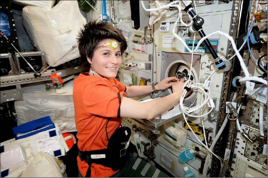
- ESA astronaut Alexander Gerst working on an experiment in the microgravity glovebox on the ISS. On his forehead he has a thermometer to measure his temperature continuously (Figure 37). 36)
- ESA astronaut Paolo Nespoli will be the next astronaut to take part this year, followed by Japanese astronaut Norishige Kanai in 2018, by when the experiment will have collected all of its data and more conclusions can be made.
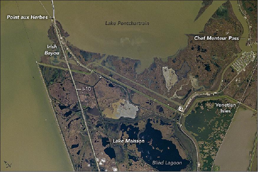
• June 12, 2017: An astronaut aboard the International Space Station took this photograph of eastern New Orleans, along the southeastern shores of Lake Pontchartrain (Figure 38). Known as the rural side of New Orleans, the landscape is largely lakes, marshes, and bayous, widely dispersed suburbs, and Bayou Sauvage National Wildlife Refuge, the largest urban refuge in the United States. 37)
- The geographic names of the region—Point aux Herbes, Lake Maisson, Irish Bayou—reflect the influence of European settlers. New Orleans was established by French colonists in the 1700s, later ruled by Spain, and then finally sold to the United States as part of the Louisiana Purchase in 1803. The Irish cultural heritage stems from a wave of immigration in the early nineteenth century.
- In contrast with the significantly older downtown area, most of the development in Eastern New Orleans began in the 1960s. Hurricane Katrina (2005) caused extensive damage to this area, closing a large number of businesses and halting development—a situation from which the area has not yet recovered.
- Interstate 10, the fourth largest and the southernmost interstate highway in the U.S., runs through the scene. It stretches from downtown New Orleans (approximately 33 km south of Blind Lagoon) and across the Twin Span Bridge at the top of the image.
- According to National Weather Service records, an estimated 106 tropical cyclones have hit Louisiana since the 1850s, or every 2.8 years. With an average elevation below sea level, the entire New Orleans area is particularly vulnerable to these violent storms. The geometry of the eastern Louisiana coastline and of the Mississippi River delta creates a "corner" that sticks out into the Gulf of Mexico. When there is a storm surge, it is amplified by these coastal features, frequently leading to severe flooding.
• May 26, 2017: ESA astronaut Thomas Pesquet at work on the International Space Station during maintenance of the Biolab. Biolab is an experiment facility located in the European Columbus laboratory that supports biological experiments on micro-organisms, cells, tissue cultures, small plants and small invertebrates. Performing life science experiments in space identifies the role that weightlessness plays at all levels of an organism, from the effects on a single cell up to a complex organism including humans. 38)
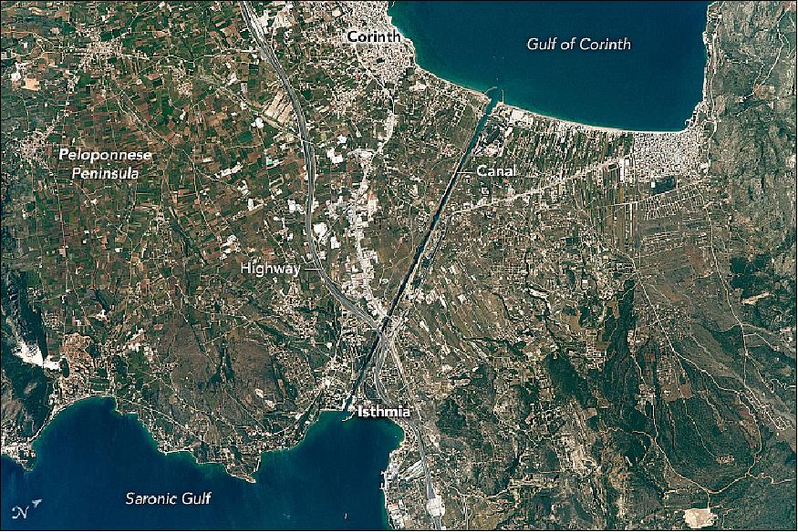
• May 22,2017: This photograph (Figure 40), taken by an astronaut aboard the International Space Station, shows the straight line of the Corinth Canal as it crosses a narrow isthmus between mainland Greece (right) and the Peloponnese Peninsula. The canal cuts through the narrowest part of the isthmus of Corinth. The towns of Corinth and Isthmia stand near the west and east ends (north is to the upper right). Near the center of the image, a highway crosses the canal and connects Athens to the Peloponnese. 39)
- Twenty-six hundred years ago, the ruler of Corinth—Periander—proposed digging a canal to connect the central Mediterranean Sea (via the Gulf of Corinth) to the Aegean Sea (via the Saronic Gulf). The goal was to save ships from the dangerous 700 km voyage around the ragged coastline of the peninsula. But the canal was still too ambitious a digging project and construction was not started.
- Not Julius Caesar, nor the Roman Emperors Caligula or Nero, were able to complete their plans for this ambitious project. The Venetians laid plans to dig the canal in the late 1600s but they never started it. In lieu of a water passage, boats have been hauled overland for centuries on a portage created by Periander. It runs roughly along the line of the modern canal.
- Construction of the modern Corinth Canal — which is 6.4 km — was started in 1882 and completed by 1893. The canal is narrow (only 21.3 meters), making many ships too wide for it. Landslides from the steep walls have occasionally blocked the canal, while channeled winds and tides also can make navigation difficult.
- An overview of the location of the Corinth Canal within Greece is provided in Figure 41.
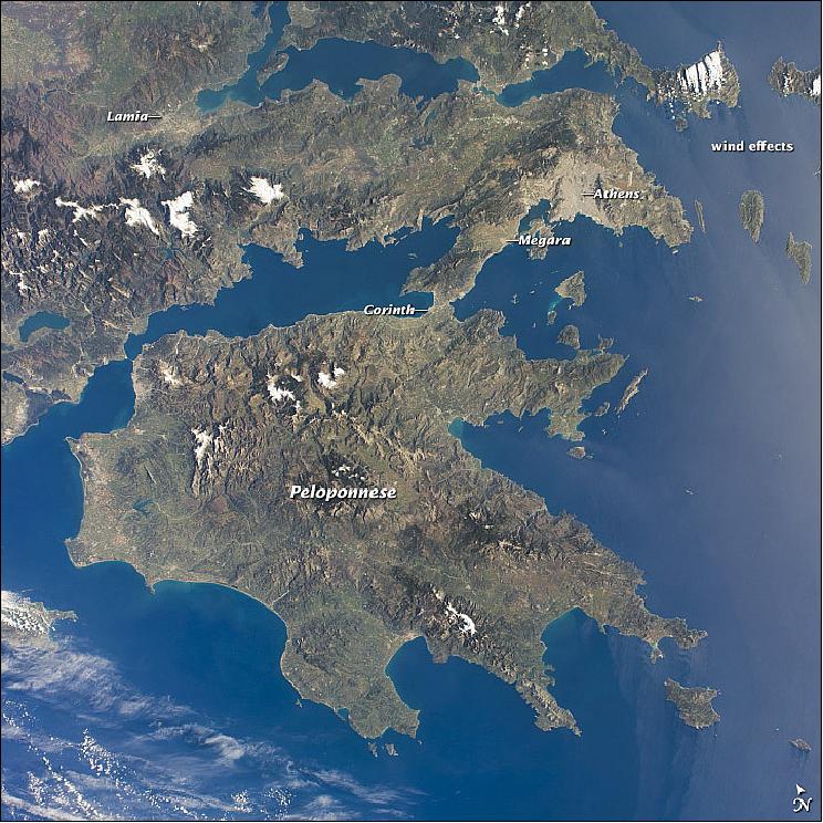
• July 14, 2014: This photo from an astronaut on the International Space Station shows much of the nation of Greece. The urban region of Athens is recognizable due to its size and light tone compared to the surrounding landscape; the smaller cities of Megara and Lamia also stand out. Dark-toned mountains with snow-covered peaks contrast with warmer, greener valleys where agriculture takes place. The intense blue of the Mediterranean Sea fades near the Sun's reflection point along the right side of the image, and numerous wind streaks in the lee of the islands become visible. 40)
- The Peloponnese—home in ancient times to the city-state of Sparta—is the great peninsula separated from the mainland by the narrow isthmus of Corinth. Several times over the centuries these narrows have acted as a defensive point against attack from the mainland. More recently in 1893, the narrows provided a point of connection when a ship canal was excavated between the gulfs to the west and to the east.
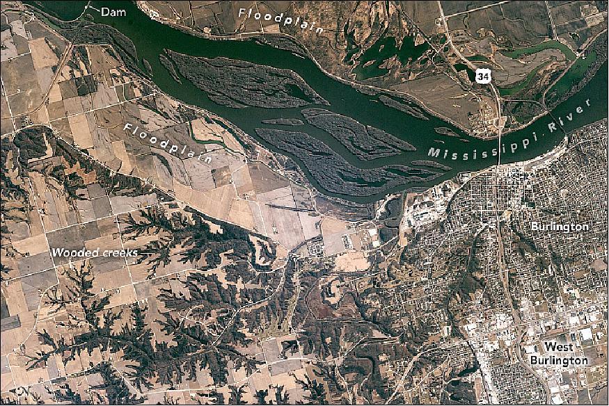
• May 15, 2017: The city of Burlington, Iowa, is situated on high bluffs next to the Mississippi River. The city thus has a commanding view of the wooded, finger-like creeks that lead down to the river; of the low floodplain and its farm fields; and the forested islands in the middle of the river. The Mississippi narrows significantly at Burlington, making a convenient location for two bridges. (For scale, the Interstate 34 bridge is 660 meters long.) A dam slows flow of the Mississippi River, but includes a lock to allow barge traffic to pass. 41)
- Major floods along the Mississippi tend to spill water onto the low floodplain, such that the view from Burlington—which stands about 40 meters above the river—would show the islands and floodplain entirely under water. The largest flood recorded at Burlington occurred in June 2008, when the river rose to 7.84 m, more than 3 m above flood stage.
• May 12, 2017: Expedition 51 Commander Peggy Whitson and Flight Engineer Jack Fischer of NASA concluded their spacewalk at 1:21 p.m. EDT (17:21 GMT). During the spacewalk, which lasted just over four hours, the two astronauts successfully replaced a large avionics box that supplies electricity and data connections to the science experiments. 42) 43)
- The astronauts also completed additional tasks to install a connector that will route data to the AMS-02 (Alpha Magnetic Spectrometer-02), repair insulation at the connecting point of the Japanese robotic arm, and install a protective shield on the PMA-3 (Pressurized Mating Adapter-3). This adapter will host a new international docking port for the arrival of commercial crew spacecraft.
- Spacewalkers have now spent a total of 1,247 hours and 55 minutes working outside the station during 200 spacewalks in support of assembly and maintenance of the orbiting laboratory. The first spacewalk in support of International Space Station assembly and maintenance was conducted on Dec. 7, 1998, by NASA astronauts Jerry Ross and Jim Newman during space shuttle Endeavour's STS-88 mission. Astronauts completed attaching and outfitting of the first two components of the station, the Russian Zarya module and the U.S. Unity module.
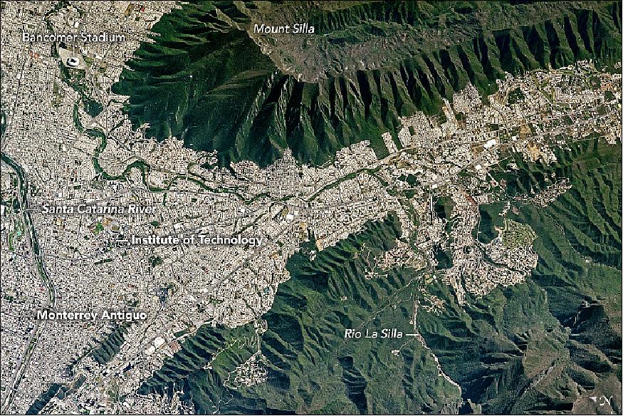
• May 10, 2017: An astronaut aboard the International Space Station captured this view of the southeastern portion of Monterrey, capital of the Mexican state of Nuevo Leon (Figure 44).
- Mount Silla—also referred to as Cerro De La Silla or Saddle Hill—is an iconic landscape feature of the region. When viewed from the west, the ridges and peaks resemble a saddle. Mount Silla has been declared a natural monument under the guidelines of the World Commission on Protected Areas. The Monterrey metropolitan area sits 1300 m below the steep, forested flanks of the mountain.
- Monterrey straddles several large rivers flowing out of the mountains. The Santa Catarina River cuts through the older parts of the city (such as Monterrey Antiguo). Major highways follow the river to the nearby cities of Guadalupe, San Pedro Garza, and Santa Catarina. Rio La Silla (Chair River) flows from the northern Sierra Madre Oriental mountain range and joins the Santa Catarina just outside the top left corner of the image. The semi-arid climate keeps these rivers dry for much of the year.
- Nuevo Leon state is home to the third largest economy in Mexico thanks to Monterrey's extensive manufacturing facilities and infrastructure. The size and reputation of Monterrey was built by the concentration of national and foreign industries; various metal products, chemicals, textiles, plastics, and glass are all made here. The city is also home to the massive Bancomer Stadium and one of Mexico's largest universities, the Monterrey Institute of Technology and Higher Education.
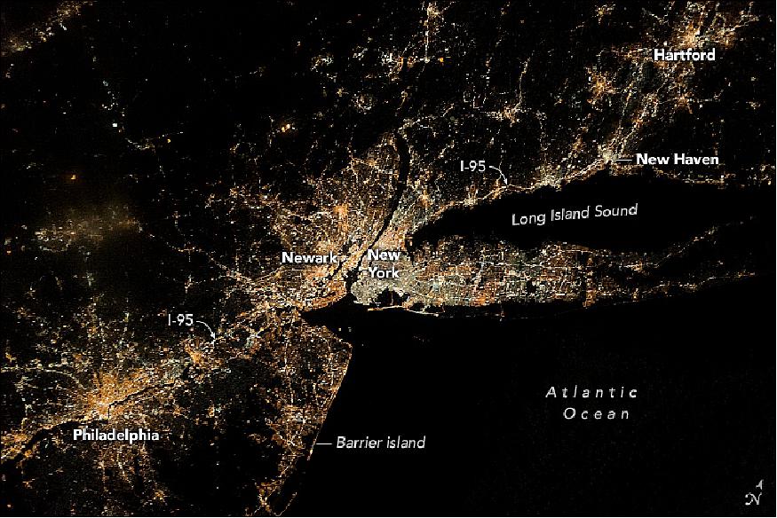
• May 01, 2017: An astronaut aboard the International Space Station centered this photograph on the largest group of lights in the northeastern United States (Figure 45). New York City and Newark, New Jersey, lie at the center of a string of city lights stretching roughly 300 kilometers from Philadelphia to Hartford. The characteristic shape of Long Island, during night and daylight overpasses, is one of the most recognizable features to an astronaut looking at the Northeast coast. 44)
- Night-light intensity indicates population densities, a phenomenon well-known to urban geographers. An important pattern is the progressive decline of population density away from the cores of the largest cities. Lower population densities appear in the southern counties of New Jersey, though the barrier islands are defined by narrow shoreline developments. Some rural areas in the photo have fewer lights than shipping lanes of the North Atlantic Ocean.
- A network of thin lines indicates highways and main roads—which can be difficult to discern in daylight images—radiating from the major cities. One of the brightest lines is Interstate 95 (I-95), which crosses the entire image from a point west of Philadelphia through New York—where it is overwhelmed by city lights—and along the coast of Connecticut.
• April 28, 2017: Astronauts in space are valuable sources of scientific data. Researchers collect blood and urine samples to understand what effects living in weightlessness has on their bodies. For one experiment, investigators are interested in their breath. The Airway Monitoring experiment measures the level of nitric oxide in astronauts' lungs, a naturally occurring molecule produced in the lungs to help regulate blood flow. Small amounts are normal, but excess levels indicate airway inflammation caused by environmental factors such as dust and pollutants or diseases like asthma. — The Karolinska Institutet in Stockholm, Sweden, is analyzing astronauts' exhaled air to probe lung health. The results so far have been breathtaking. 45)
- A breath of pressurized air: With each lungful of air, our bodies absorb oxygen and exhale waste-product molecules such as carbon dioxide – and the important signalling molecule nitric oxide. The Airway Monitoring experiment looks at the amount of nitric oxide the astronauts expel in the airlock. 46)
- Aboard the Station, astronauts breathe into an analyzer at normal pressure and in the reduced pressure of the Quest airlock – similar to the pressure in future habitats on Mars and lunar colonies. The measurements are then compared to those taken before flight.
- Preliminary results are surprising. While nitric oxide levels were lower throughout astronauts' stays in space, as expected, they found that the levels initially decreased just before flight. Researchers are not yet sure why this is the case. - But the lower nitric oxide levels in astronauts' lungs means researchers have to reset the level considered to be ‘healthy' for spaceflight.
- If what is considered a normal level of nitric oxide in humans on Earth could in fact be a sign of airway inflammation for astronauts in space, researchers have a more accurate standard from which to conduct further research on lung health in space.
- This information is key to ensuring the health and safety of astronauts on longer missions further from Earth. Understanding the effects of weightlessness and reduced pressure on airway health allows us to solve future problems. This in turn will help space explorers monitor, diagnose and treat lung inflammation during spaceflight.
- For now, data from the remaining astronaut participants are needed before definitive conclusions can be made. But, overall, researchers have a better understanding of the lungs that will go a long way towards developing better diagnostic tools for airway diseases in patients on Earth.
• April 24, 2017: 534 days, 2 hours, 49 minutes and counting. NASA astronaut Peggy Whitson flew through the standing record for cumulative time spent in space by a U.S. astronaut at 6:27 GMT on April 24, 2017, and with the recent extension of her stay at the International Space Station, she has five months to rack up a new one. 47)
- Record holder is a familiar title for Whitson – she's held several over the course of her NASA career. In 2008, Whitson became the first woman to command the space station, and on April 9 became the first woman to command it twice. In March, she seized the record for most spacewalks by a female. Now, after launching on Nov. 17 with 377 days in space already under her belt, she's surpassed astronaut Jeff Williams' previous United States record of 534 days, 2 hours and 48 minutes of cumulative time in space.
- This is Whitson's third long-duration stay onboard the space station, and in March her mission was extended into September, increasing the amount of valuable astronaut time available for experiments on board the station. When she returns to Earth, she'll have spent more than 650 days in space, and decades supporting spaceflight from the ground.
- Whitson began her NASA career in the 1980s. With a doctorate in biochemistry, she held a number of research-related positions, and in 1992 was named project scientist of the Shuttle-Mir Program. She also served as deputy division chief of the Medical Sciences Division at NASA's Johnson Space Center in Houston and co-chair of the U.S.-Russian Mission Science Working Group before being selected as an astronaut in 1996.
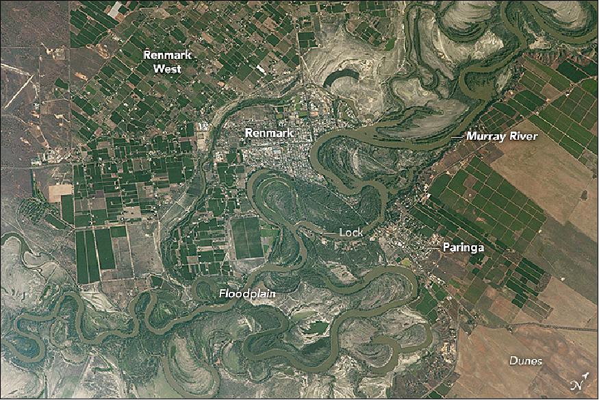
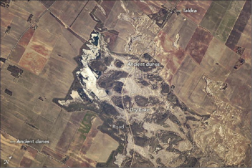
• April 24, 2017: An astronaut aboard the International Space Station captured these photographs of agricultural patterns in the Riverland region of South Australia. The use of a powerful lens makes it possible to see individual buildings in the small towns, a bridge joining the towns, and one of the many locks on the river. 48)
- Renmark is one of the major towns in a line of settlements along the Murray River. The image of Figure 48 shows the winding course of the Murray in a wide floodplain, with numerous small farm plots clustered along its banks. This heavily irrigated country is a mix of grapevines, almond groves, stone-fruit orchards (like peaches and apricots), and citrus orchards. More than half of South Australia's famed wine production comes from this area.
- The intensely farmed landscape contrasts with the arid landscape in Figure 49, which shows an area just 20 km south of Renmark. A large, dry lake is crossed by a winding road. Rounded, ancient dunes stand south of the settlement of Taldra. The dry lake has been the site of growth trials for a salt-tolerant giant cane crop, according to local agriculture officials.
- Surrounding the lake is sparser vegetation that allows the underlying linear dunes to remain visible from space. The surrounding fields show faint parallel lines that indicate a plowing pattern. These fields are part of a mixed farming agriculture in which crops (mainly wheat and barley) are grown for two years, after which the fields provide pasture for grazing livestock.
• April 20, 2017: If anything should break in space, let it be records. The astronauts of Expedition 50 have done just that by setting a new record for most time spent on scientific research on the International Space Station. ESA astronaut Thomas Pesquet, NASA astronauts Shane Kimbrough and Peggy Whitson, and cosmonauts Oleg Novitsky, Andrei Borisenko and Sergei Ryzhikov clocked a combined 99 hours of science in the week of 6 March. 49)
- To put this into perspective, astronauts average a 40 hour working week split between science experiments, Station maintenance and exercising for 2.5 hours a day. The record-breaking hours exclude these non-science tasks.
- Mission control tracks these statistics, as the number of hours devoted to science has fluctuated over the years on account of the Station's construction. Built over the years in segments, astronauts needed to assemble and maintain the orbital complex while also running experiments.
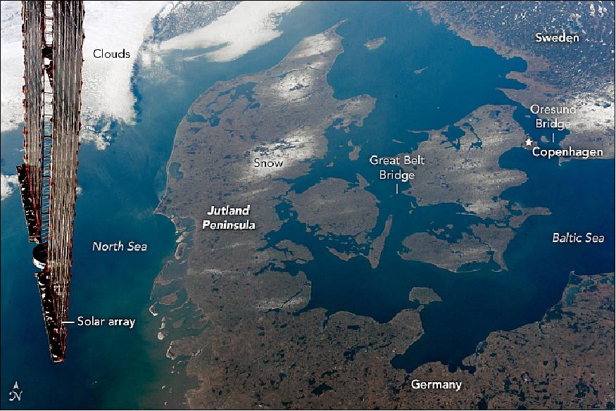
• April 17, 2017: Shot by an astronaut aboard the International Space Station, this oblique photograph (Figure 52) shows most of the Kingdom of Denmark. This Nordic country lies between the Baltic Sea to the east and the North Sea to the west. The winding channels that connect the two seas are international waterways known as the Danish Straits. 51)
- The long Jutland Peninsula of western Denmark is connected to northern Germany, while the eastern half is comprised mostly of smaller islands in the Danish Archipelago. The larger islands are joined by some of the longest bridges in the world—the Storstrom, the Great Belt, and the Oresund, which joins Denmark to Sweden. The names correspond to the straits between the islands.
- During the last Ice Age (referred to as the Pleistocene Epoch), much of northwest Europe was covered with thick glaciers. Glacial deposits and kettle lakes were left behind when the ice retreated. Lowland areas now dominate Denmark, which has a mean elevation of just 34 meters above mean sea level.
- Much of the landscape is covered by wetland ecosystems of bogs filled with peat. This decayed plant matter is used as a natural resource in energy production in several northern European countries. Bogs in Europe often contain major archeological sites, and peat harvesters have stumbled upon ancient human remains that tend to be very well preserved by the highly acidic peat. The most famous Denmark "bog body" is Tollund Man, who lived in the 4th century BCE (Before Common Era).
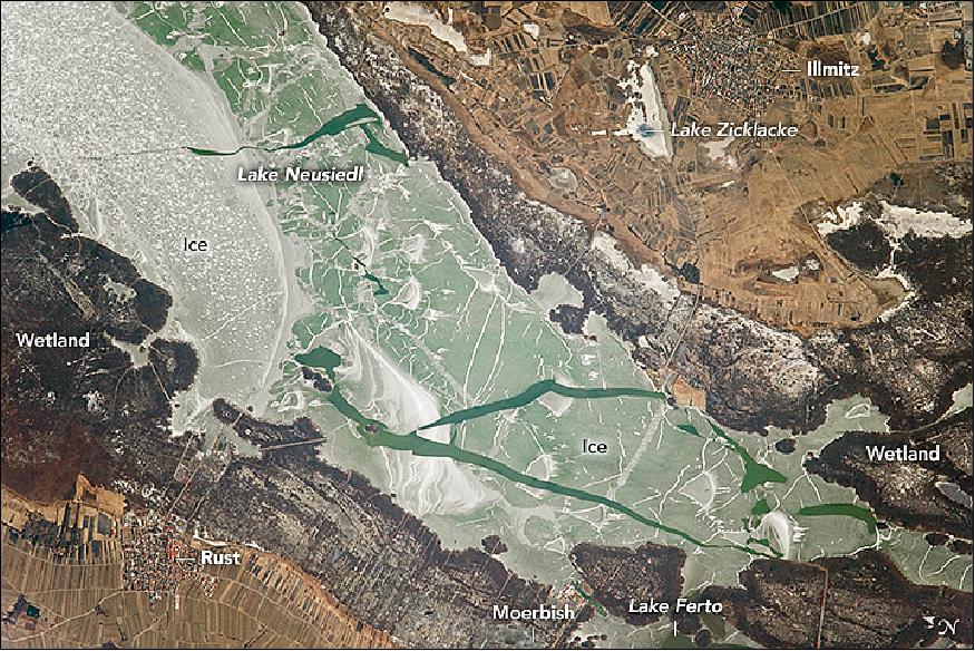
• April 10, 2017: An ISS astronaut took this photograph of the south end of Lake Neusiedl (Figure 53), which spans the border between Austria and Hungary (it is known as Lake Ferto in Hungary - literally meaning a swamp). The pattern of open-water cracks amidst the ice hint at the beginning of a spring warm-up in the middle of this 30 km long lake. 52)
- In summer, the lake is a popular vacation locale, situated about 45 km southeast of Vienna, Austria. Lake Neusiedl is also known as the "Sea of the Viennese." Extensive boating facilities line the shore, based primarily near the villages of Rust and Moerbisch. - At just 2 meters maximum depth, the lake is one of the shallowest in Central Europe. One well-known event for vacationers is the "annual freestyle mass crossing" of the lake from the village of Moerbisch to the village of Illmitz.
- The wide, reed-covered wetland that fringes the lake is crossed by drainage canals and agricultural fields. Historical records indicate that these reed beds have been entirely under water at times because the lake size varies greatly with weather conditions. For example, the lake expanded to double its present size in 1768. More dramatically, the lake has dried up completely on several occasions: 1740–1742, 1811–1813, and 1866–1871. At very low stages, the lake has been described as a swamp because the reeds dominated the middle of the lake. Small depressions like Lake Zicklacke (upper center) dry up and fill on shorter time spans.
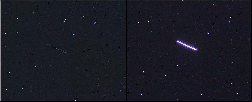
• On March 30, 2017, NASA astronauts Shane Kimbrough and Peggy Whitson ventured outside the International Space Station on a seven-hour spacewalk. The duo's work included installing four thermal shields on the US Tranquility module, protecting a docking port. Unfortunately, one shield (blanket) was lost during the spacewalk and floated away. It posed no immediate danger to the astronauts and they went on to install the remaining shields on the port. The lost shield is in orbit some distance in front of the Station and is visible from Earth through a pair of good binoculars. 53) 54)
- During the evening of 3 April, Marco Langbroek, from Leiden, the Netherlands, photographed the shield passing over in the night sky, using a Canon EOS 60D DSLR camera and a Samyang 1.4/85 mm lens.
- "The item poses very little risk to navigation, and an accidental release like this is not unexpected given the complexity and challenges of working outside during a spacewalk," says Holger Krag, Head of ESA's Space Debris Office. He says the incident does, however, put a spotlight on the current space debris situation. "There are some 750,000 debris objects 1–10 cm in orbit, and any one of these could damage or destroy a functioning satellite."
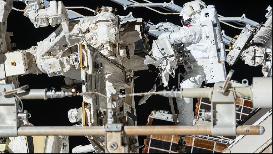
• March 28, 2017: ESA astronaut Thomas Pesquet completed his second spacewalk on Friday, 24 March 2017 along with NASA astronaut Shane Kimbrough. NASA astronaut Peggy Whitson remained inside to help the duo suit up, exit and reenter the Station. 55) 56)
- Spacewalks often include routine maintenance of the International Space Station. The to-do list this time included disconnecting cables and electrical connections on the PMA-3 (Pressurized Mating Adapter-3) to prepare for its robotic move on March 26. The astronauts also , lubricated the latching end effector on the Dextre robotic hand, inspected a radiator valve, and replaced cameras on the Japanese segment of the outpost. In this photo (Figure 55), Thomas is working on the Canadarm2 robotic arm. Standing on a foot restraint, he is using a lubrication tool (it resembles a selfie stick) to oil Dextre. The spacewalk lasted 6 h 34 min.
- The PMA-3 provides the pressurized interface between the station modules and the IDA (International Docking Adapter), which will accommodate commercial crew vehicle dockings.
- Thomas is scheduled to complete one of the two remaining spacewalks for Expedition 50. He will next venture out with Peggy, bringing his spacewalk total up to three on his first mission.
• Between EVA-40 and EVA-41, robotic operations conducted the relocation of the PMA-3 (Pressurized Mating Adapter-3). In its old location on Node 3 Port, PMA-3 was unusable as a docking port due to clearance issues with the station structure. The last time that PMA-3 was actually used for a docking was during the STS-98 shuttle mission in February 2001, and since that time it has been shuffled around different ports on the ISS and used for storage. 57)
- However, with commercial crew vehicles soon coming online, which will use the "direct handover" model for crew transfers, PMA-3 has now found a use once again as a second docking port for commercial crew vehicles.
- At one time a plan was under consideration to return PMA-3 to Earth on the final Space Shuttle flight, STS-135, in July 2011, as it was not envisaged at that time that PMA-3 would ever be used again, since the plan then was to build two Common Docking Adapters (CDAs), which were flat devices to convert ISS Common Berthing Mechanism (CBM) ports to commercial crew docking ports.
- However, it was subsequently decided to retain the PMAs as docking ports for commercial crew vehicles, rather than build a brand-new docking adapter, as the PMA's tunnel-like design provides a good amount of spacing between visiting vehicles and the ISS, thus avoiding any clearance issues between vehicles and the station structure.
- With PMA-3 relocated to Node 2 Zenith by robotic means, it will need to have an International Docking Adapter (IDA) installed onto its end, in order to convert its Androgynous Peripheral Attachment System (APAS) compatible docking port to a Soft Impact Mating Attenuation Concept (SIMAC) compatible port for future crew vehicles.
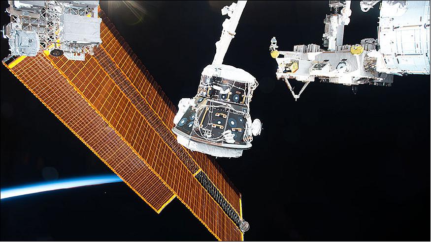
Legend to Figure 56: Ground-based robotics teams remotely commanded the International Space Station's robotic Canadarm2 to move the Space Shuttle-era PMA-3 to the forward end of the outpost. The March 26, 2017, relocation was part of a multi-year effort to prepare the ISS for future commercial crew spacecraft.
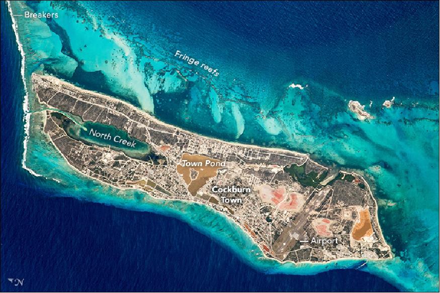
• March 20, 2017: An astronaut aboard the International Space Station took this photograph of Grand Turk Island, situated on the southern end of the Bahamas archipelago in the Turks and Caicos Islands. Grand Turk Island is just 10 km long, and much of the island is occupied by Cockburn Town (population about 5,000), the capital of Turks and Caicos (Figure 58). 59)
- Much of the land surface is covered by reddish-brown salt evaporation ponds and a saline lake known as Town Pond, around which Cockburn Town developed. The town was established in 1766 to support the growing salt industry. McCartney Airport, on the southern end of the island, is the largest airport.
- Grand Turk sits on a large carbonate bank, which is almost double the size of the island. Waves breaking against the carbonate platform appear as a white line along the left margin of the image. The complex patterns on the east coast of Grand Turk (top of the image) are a fraction of a vast reef ecosystem that stretches discontinuously for nearly 1000 kilometers, as far as the northern Bahamas.
- The color of the water in this photo tells us something about the depth: clear, shallow water is electric blue where the light-toned sands almost meet the surface; deeper blues indicate deeper water. The darkest blues indicate the deep ocean (lower left) and the Columbus Passage. Dipping at least 2150 m in depth, the passage is known to divers for majestic underwater caverns, coral gardens, and black-coral formations. Tourists visit the passage every January through March to watch thousands of Atlantic humpback whales migrate to their mating grounds.
- Grand Turk Island has an important historical connection to NASA and the United States. The first crewed orbital mission of the United States was launched with John Glenn piloting the Friendship 7 spacecraft in 1962. He successfully orbited the Earth three times and, after various complications, splashed down in the vicinity of Grand Turk Island. Glenn was taken to Cockburn Town for several days for medical checkups and debriefing.
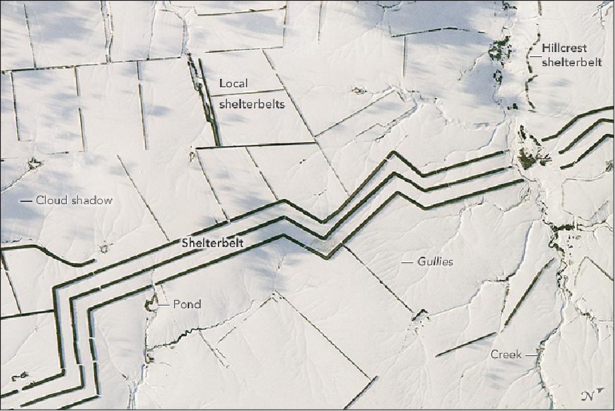
• March 13, 2017: The dark, angular lines crossing this snowy landscape attracted the attention of an astronaut looking down from the International Space Station. The photograph of Figure 59 shows the parallel lines of a major shelterbelt—also known as a windbreak—crossing the steppes of southern Russia near the Volga River (Volgograd Oblast). The image shows a 14-kilometer section of an extensive system of shelterbelts planted to protect crops and reduce the erosion of steppe soils by wind. The shelterbelt is broken where it meets a local stream. 60)
- Each of the north-south trending lines is a dense mass of trees about 60 meters wide. The trees throw shadows to the east in this late afternoon view (north is to the right). Together the three lines span about 800 meters, and there is enough space between the rows of trees for narrow fields to be tilled.
- Shelterbelt construction began when open steppe landscapes were first settled by Russian famers in the early 1700s. At present, more than 2 million hectares (200 km2) of the steppes have been planted. The soils within the main shelterbelts in this region have been shown to be significantly improved, becoming richer in organic carbon than virgin soils that have never been plowed.
- The photograph also shows narrower lines of trees along farm boundaries; these protect individual fields from winds and associated gully erosion. The trees also protect water bodies from evaporation by the steady winds, and they prevent ponds and streams from filling with blown sand and silt. Lines of trees at the crest of the creek bank protect the creek valley (top right).
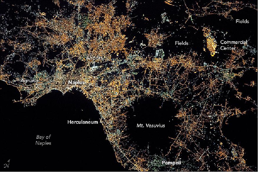
• March 6, 2017: An astronaut aboard the International Space Station took this photograph of the city lights of Naples and the Campania region of southern Italy. A regional view of Italy from 2014 shows the Naples region to be one of the brightest in the country. Roughly three million people live in and around this metropolitan area (Figure 60). 61)
- The different colors of lights in the scene reflect some of the history of development in the area. The green lights are mercury vapor bulbs, an older variety that has been replaced in newer developments by orange sodium bulbs (yellow-orange). To the northeast, the lightless gaps between the homes and businesses are agricultural fields. The bright yellow-orange complex amidst the fields is the CIS emporium, the largest commercial retail facility in Europe.
- The large black circular area in the photo is Mount Vesuvius, the only active volcano on Europe's mainland. Vesuvius is a stratovolcano, made up of different materials—pyroclastic flows, lava flows, and debris from lahars—that accumulated to form the volcanic cone. Although any volcanic materials can endanger surrounding communities, pyroclastic flows of superheated ash and gas are among the most dangerous, moving at speeds of hundreds of kilometers per hour. The cities of Pompeii and Herculaneum were destroyed in 79 AD by pyroclastic flows, which trapped more than 16,000 people.
- Such historic catastrophes—and the fact that 600,000 people live in the immediate vicinity—are the reason the volcano is one of the most heavily monitored in the world, with several dozen sensors located at many points on and around the cone. By dating lavas, scientists know that Mount Vesuvius has had eight major eruptions in the past 17,000 years.
- Vesuvius is part of the Campanian Volcanic Arc which includes the Campi Flegrei caldera/geothermal field to the west of Naples near Agnano and Mount Etna in Sicily.
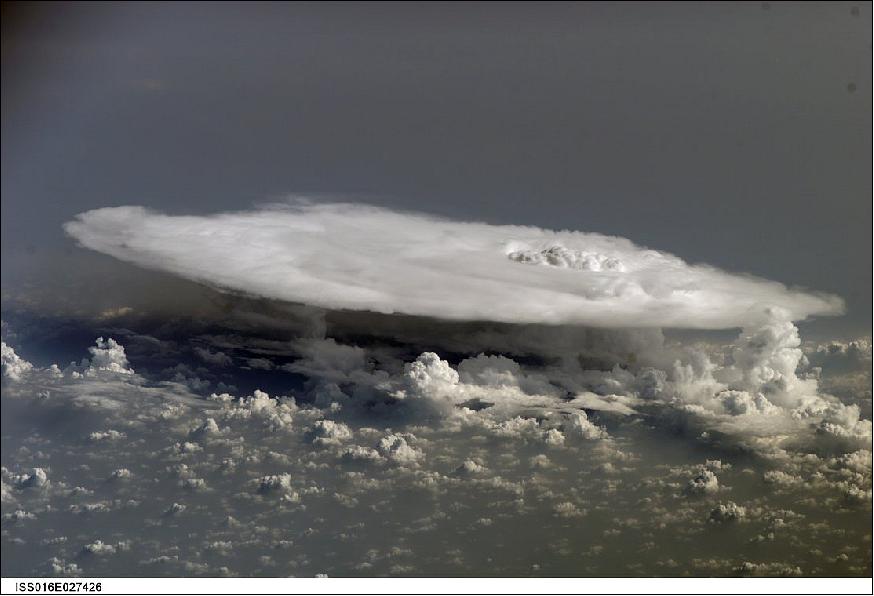
• February 8, 2017: For years, their existence has been debated: elusive electrical discharges in the upper atmosphere that sport names such as red sprites, blue jets, pixies and elves. Reported by pilots, they are difficult to study as they occur above thunderstorms. — ESA astronaut Andreas Mogensen during his mission on the International Space Station in 2015 was asked to take pictures over thunderstorms with the most sensitive camera on the orbiting outpost to look for these brief features. 62)
- Andreas aimed for cloud turrets – cloud pillars extending into the upper atmosphere – and shot a 160 second video showing 245 blue flashes from the top of a turret that drifted from the Bay of Bengal's thunderstorm. The blue discharges and jets are examples of a little-understood part of our atmosphere. Electrical storms reach into the stratosphere and have implications for how our atmosphere protects us from radiation.
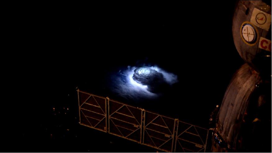
- Satellites had probed these events but their viewing angle is not ideal for gathering data on the scale of the blue jets and smaller blue discharges. In contrast, the Station's lower orbit is ideally placed to capture the sprites and jets.
- ESA astronaut Tim Peake took the image of Figure 62 circling Earth 400 km up in the International Space Station. He commented: "Sometimes looking down on Earth at night can be kinda spooky." - Although this picture was taken in Tim's free time, the Station is used for research into elusive phenomena in the upper atmosphere during thunderstorms – red sprites, blue jets and elves. Some of the most violent electric discharges are very difficult to capture from the ground because of the atmosphere's blocking effect. From space, astronauts can judge for themselves where to aim the camera, where to zoom in and follow interesting regions for researchers.
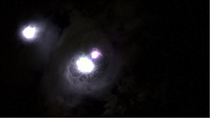
- Denmark's National Space Institute has now published the results, confirming many km-wide blue flashes around 18 km altitude, including a pulsating blue jet reaching 40 km. A video recorded by Andreas as he flew over the Bay of Bengal at 28 800 km/hr on the Station shows the electrical phenomena clearly – a first of its kind. 63)
- Thunderstorm clouds may reach the lower stratosphere, affecting the exchange of greenhouse gases between the troposphere and stratosphere. This region of the atmosphere is difficult to access experimentally, and our knowledge of the processes taking place here is incomplete. We recently recorded color video footage of thunderstorms over the Bay of Bengal from the International Space Station. The observations show a multitude of blue, kilometer-scale, discharges at the cloud top layer at ~18 km altitude and a pulsating blue discharge propagating into the stratosphere reaching ~40 km altitude. The emissions are related to the so-called blue jets, blue starters, and possibly pixies. The observations are the first of their kind and give a new perspective on the electrical activity at the top of tropical thunderstorms; further, they underscore that thunderstorm discharges directly perturb the chemistry of the stratosphere with possible implications for the Earth's radiation balance.
- The Thor Experiment: Named after the Nordic mythological god of thunder and lightning, the Thor experiment is designed to study processes at the top of thunderstorms and the atmosphere just above. The science objectives of the experiment are the formation of cloud turrets, the generation of high-altitude electrical processes, and generation of internal gravity waves from thunderstorm convection. In the experiment astronauts on the ISS image thunderstorms under conditions defined by the science team and the observations from the ISS are correlated data from other sources such as meteorological satellites and radars and ground-based lightning detection systems.
- Thor was carried out for the first time from 2 to 11 September 2015, during the Iriss mission of Denmark's first astronaut, Andreas Mogensen. A science team on the ground forecasted thunderstorm activity up to 3 days in advance, predicting storm locations, observation time windows for ISS overflights, and camera pointing angles, and the information was uploaded to the ISS every 24 hr. The forecasting procedure allowed mission schedulers to plan for several observation periods in the busy timeline of the astronaut. The measurements presented here were taken from the Cupola, a module underneath the ISS with a full view of the Earth.
- The camera was a Nikon D4 set at 6400 ISO and recording 24 frames per second at 1920 x 1080 pixels, down-scaled from 4928 x 2768 pixels of the sensor. It was mounted with a 58 mm/f1.2 lens, giving a 34.4° x 19.75° field of view corresponding to 1.07 arcsec/pixel. With these settings, the camera resolution was 130 m at nadir, 728 m at the limb, and 203 m for the discharge events pictured in Figures 64 and 65. Based on the ISO setting (giving the light level for minimum darkening) and assuming a linear response, we estimate the camera response to be 10 nW/bit. The data were recorded on a memory card and downloaded within a few hours to the supporting science team.
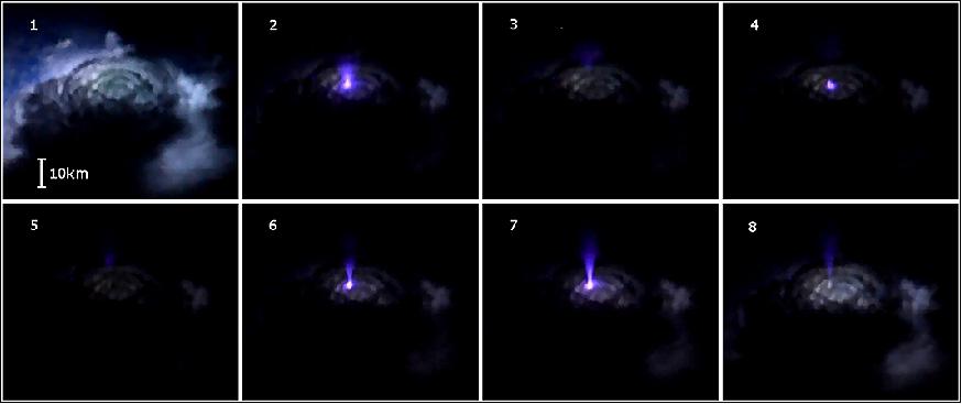
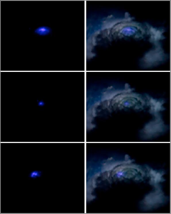
The images of Figures 64 and 65 are from a video of a thunderstorm over the eastern coast of India and the Bay of Bengal. It is 160 s in duration and is taken on the night of 8 September 2015, around 22:20 UTC (03:50 LT).
• February 6, 2017: Flying over southeastern Australia, an astronaut aboard the International Space Station took this photograph of the center of Melbourne (Figure 66). With a population of about 4.5 million people (as of 2015), greater Melbourne is the second-most populous city in Australia after Sydney. 64)
- The city straddles the Yarra River, which runs through the view as a darker line. Like most high-rise city centers, the center of Melbourne appears darker due to the long shadows cast by closely-spaced, tall buildings. The riverside sector is the tourist and conventioneer magnet; the Convention Center is one of the largest buildings in the neighborhood.
- Angular patterns along the river (the Docklands) and the protected shoreline of Port Phillip Bay are transhipment facilities—interchanges between road, rail, and sea transportation. Melbourne is Australia's busiest container port, with a well-developed railroad and freeway network to distribute goods, as shown by the tracks and highways immediately north of the Docklands.
- Green patches in the image are parks, the largest being immediately east of the city center. The Sports and Entertainment Precinct occupies one of these open spaces. It is home to the largest (circular) stadium in the southern hemisphere, the iconic Melbourne Cricket Ground (founded in 1853). On the opposite bank of the Yarra River lies the state governor's mansion known as the Government House. A smaller park hosts the Royal Exhibition Building, the venue of the first Parliament of Australia. With a design based partly on Florence Cathedral, the building was the first non-Aboriginal cultural site in Australia to win UNESCO's World Heritage listing.
- Various place names reflect the time when Melbourne was founded. At its founding in 1835, the city was named in honor of the British Prime Minister (William Lamb, 2nd Viscount Melbourne). In 1851, it became the capital of the newly founded colony of Victoria, named for the British Queen. Roads and parks are also named after Queen Victoria's husband Prince Albert.
• On January 24, 2017, teachers from Romania, Ireland, and Portugal, had the opportunity to talk with ESA Astronaut Thomas Pesquet, who is currently living and working on the ISS (International Space Station). Hundreds of primary and secondary school teachers and students, as well as space scientists and engineers, gathered at national events in Timisoara, Limerick, and Lisbon to participate in the call with Thomas – the opportunity of a lifetime. Several teachers had the opportunity to ask questions surrounding the theme: space in our daily lives. 65)
- "Today was fantastic. I'm really looking forward to taking this back to the classroom and to talk to the students so that they can share this with their friends and family. I'm sure they will have many more questions tomorrow," said Mary Gorky, a teacher from Ireland.
- ''It's not every day that we, especially high school students, get to learn things about space in this unusual and fun way. I personally think that the information we learned today covers a little part of the theoretical background regarding the space outside our own planet that each one of us should have. The conversation we had with Thomas, but also with the people who talked to us in the local presentations before the call, as well as the questions that were asked, are the sort of things that spark one's interest," said Roxana Drăghia, an 11th grade Romanian student.
- "The students were very interested in the possibility of working in space technology in the future, and the event gave me material that can be developed further in the classroom," said César Marques, one of the many Portuguese teachers attending the event in Lisbon.
Thomas Answered the Following Questions
1) When we think of space, most people think of exploration. What are some other activities related to space that society may not be aware of?
2) What kind of research are you conducting during your Proxima mission that could contribute to new technologies to be used in our daily lives?
3) How long does it take for the research, experiments, and new findings done on the ISS to be used in technologies and medicine here on Earth?
4) How does your time in space help us to improve methods of caring for sick people here on the ground?
5) How do you test for water and bacterial contamination on the ISS? Are these testing methods also used on Earth for other purposes?
6) When a natural disaster happens on Earth, can you see it from space? Is there a way that you or ESA can send a warning back to Earth?
7) What new technologies related to navigation are being used on the ISS and in space, which can benefit us here on Earth?
8) Do you think it is possible to live in a completely self-sustainable environment in space? Are there any technologies from Earth that are helping this become a reality?
9) What do you think is one of the most significant discoveries or inventions for society created from research carried out in space, and in particular, on the ISS?
10) I have heard that astronauts' eyesight can change in space. Will the research done related to this have other applications, such as helping prevent people on Earth from losing their sight?
About the Local Events
- The events in each country were coordinated by three of the European Space Education Resource Offices (ESERO): ESERO Romania, ESERO Ireland, and ESERO Portugal.
- Romania: the event took place in Universitatea de Vest, Timisoara; Ireland: the event took place in Limerick Institute of Technology, Limerick; and Portugal: the event took place in Pavilhão do Conhecimento Science Centre, Lisbon.
- In addition to the inflight call, the local events featured a range of activities, including talks from national space experts about the many benefits of space technologies, exploration, and research, encouraging teachers and students to explore how space contributes to the advancement of society through spinoffs and innovation, promoting international cooperation, and providing inspiration.

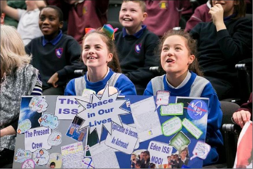
- The inflight call with Thomas Pesquet is part of a vast range of educational activities organized by ESA's Education Office and jointly delivered by its ESERO project. There are currently 10 operational ESERO Offices across Europe, covering 13 ESA Member States. ESA's ESERO project is a collaboration between ESA, national space agencies, and science education partners.
- ESEROs design, develop, and disseminate classroom resources – all tailored to the national school curricula and language - which make use of space as a rich and inspirational context for teaching STEM subjects. In addition, they offer teacher training workshops and conferences for both primary and secondary school teachers, and support educational hands-on projects in their country. Through their activities, ESEROs also raise awareness about STEM-related career prospects, particularly in the space sector, and promote the importance of space in our daily lives (Ref. 65).
• January 23, 2017: The panorama of Figure 71, photographed by an astronaut aboard the International Space Station, shows nearly the full length of Lake Powell, the reservoir on the Colorado River in southern Utah and northern Arizona. Note that the ISS was north of the lake at the time, so in this view south is at the top left of the image. 66)
- At full capacity, the reservoir impounds 24,322,000 acre-feet of water (30 km3), a vast amount that is used to generate and supply water to several western United States, while also aiding in flood control for the region. It is the second largest reservoir by maximum water capacity in the United States (behind Lake Mead).
- Landscape elevation changes are hard to see from space, but astronauts learn to interpret high and low places by their color. Green forests indicate two high places in the image that are cooler and receive more rain than the dry, low country surrounding the lake. The isolated Navajo Mountain is a sacred mountain of the Native American Navajo tribe and rises to 3,154 meters. The long, narrow Kaiparowits Plateau rises nearly 1200 m from Lake Powell to an elevation of more than 2300 m. More than 80 km long, the plateau gives a sense of horizontal scale.
- The region draws nearly 2 million people every year, even though it is remote and has few roads. Most of the area in view is protected as part of the Glen Canyon National Recreation Area and the Grand Staircase-Escalante National Monument—the largest amount of protected land in a U.S. national monument.
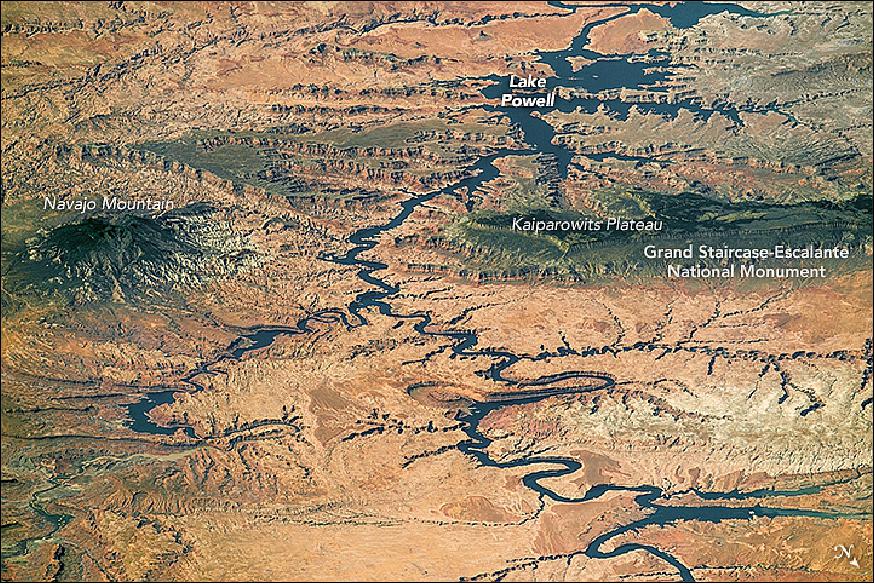
• January 9, 2017: An astronaut aboard the ISS used a long lens to capture the fleeting features of the Sun's reflection point around islands in Lake Titicaca (Figure 72). Located on the high plateau of the Andes Mountains, between Peru and Bolivia, Titicaca is the largest lake in South America with a surface area of 8,372 km2. At 3812 m above sea level, it is also one of the highest commercially navigable lakes in the world. 67)
- Astronauts see numerous complex "sunglint" patterns like these as they look down on Earth. In this photo, reflection-point patterns are strongly affected by the wind because wind-ruffled water and smooth water reflect sunlight differently. Strong westerly winds blow across Titicaca in most months of the year, disturbing the water surface and enhancing bright reflections. Wind is also channeled between steep-sided islands, making for strong reflections on both sides of Isla Suriqui. But in wind-protected zones — such as the area downwind (northeast) of Suriqui — there is no brilliant reflection to blot out the color of the lake water.
- The sunglint patterns tell other stories, too. The curved line near the top left seems to show a pulse of water entering the lake through a narrow strait. The parallel lines at image top center may represent a packet of earlier water pulses. At the lower right, straight lines of boat wakes cut across curved wind-streak lines.
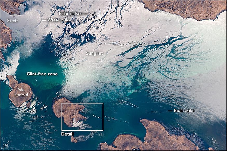
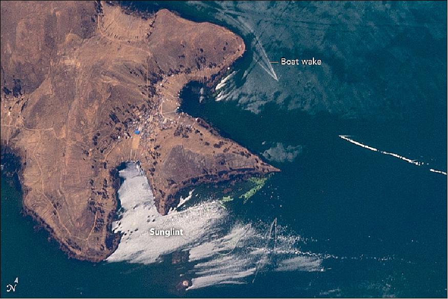
• January 2, 2017: Astronauts aboard the International Space Station used an 1150 mm lens to capture this photograph of a variety of agricultural patterns near an oasis in eastern Libya (Figure 74). This area is one of the most remote places in Africa, more than 900 km from the nearest major city. The cluster of buildings, roads, and small farming operations near the top of the photo is the town of Al Jawf. 68)
- Each farming pattern in the image is related to different irrigation methods. The honeycombs in the center are what remains of the first planned farming method in the Libyan Desert, implemented around 1970. The large circles (about 1 kilometer wide) of center-pivot irrigation systems (lower left) replaced the honeycombs in order to conserve water. The grid system (upper left) is perhaps one of the oldest known to planned agriculture, but it is still used alongside the more modern patterns.
- Near Al Jawf, the oasis is covered in lush green gardens and palm trees that survive due to pumping from the largest known fossil water aquifer in the world: the Nubian Sandstone Aquifer. More than 20,000 years ago, the Saharan landscape was wet, and heavy rainfall continuously refilled the aquifer. Today the region receives less than 0.25 cm of rain a year, making this aquifer a non-renewable resource. An agreement was recently hashed out between Libya and the UN Food and Agriculture Organization to improve food security in the region by developing the country's agriculture industry. This means the use of fossil water (ground water) will continue, and the agricultural patterns we see today are likely to survive for years to come.
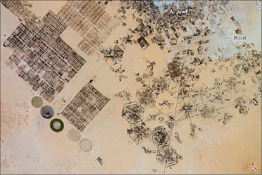
• December 11, 2016: This bright blue lake, with its tight swirl of a light-toned sediment, caught the eye of an astronaut on the International Space Station. Situated on the Idaho-Utah border, Bear Lake is one of the bigger lakes in the Rocky Mountains (Figure 75). 69)
- The two swirls near the center of the 30 km long lake are rotating in the deepest water—perhaps from outflow from Swan Creek or Fish Haven Creek. North Eden Creek has laid down a little delta at its mouth. Two center-pivot irrigation fields sit on the delta, one of the few flat places in this mountainous landscape.
- The more diffuse swirls at the north end of the lake (lower right) likely formed from sediment entering from North Eden Creek. This sediment is carried north along the shoreline by lake currents, joining with sediment eroded from the white beaches.
- When the north-end beach formed, it cut off of Bear Lake from the Mud Lake lagoon. Muddy sediments subsequently collected to form a dark-toned, vegetated wetland now protected as the Bear Lake National Wildlife Refuge. A much larger protected area is the Cache National Forest, visible across the entire top part of the image. Dramatic canyons like Fish Haven Canyon cut deeply into the Wasatch Mountains.
• November 29, 2016: MARES (Muscle Atrophy Research and Exercise System) is a three-in-one muscle-measurement machine on the International Space Station to monitor astronauts' muscles as they work out. 70)
- Muscle strength drops during spaceflight and researchers need to know why this happens in order to prepare for long missions and safe space tourism. MARES is an exercise bench that offers detailed information about how muscles behave in space. Looking at muscle contraction at a single moment gives little information but MARES provides a full overview of muscle speed and force as an elbow or knee joint bends.
- Our bodies are amazing machines that perform wonderful feats daily without us even noticing. Hold a glass in your hand and fill it with water and your arm muscles will automatically hold the glass steady and stable despite the changing weight as it fills.
- MARES can chart this fine motor control as well as give a precise overview of muscle torque and speed. Astronauts move their joints to follow a graph or dot on a screen as a motor generates counterforce.
- This week, ESA astronaut Thomas Pesquet is installing the machine in Europe's Columbus space laboratory and he will be the first test subject for researchers on Earth. Thomas' fellow ESA astronauts Andreas Mogensen, Samantha Cristoforetti and Tim Peake, tested the machine to make sure it works correctly ready for use.
- Thomas is one week into his six-month Proxima mission on the International Space Station.
• November 21, 2016: An astronaut aboard the ISS used a long lens to document what crews have termed one of the most spectacular features of the planet: the dunes of the Namib Sand Sea. Looking inland (from an ISS position over the South Atlantic) near sunset, the highest linear dunes show smaller linear dunes riding along their crests (Figure 77). Linear dunes are generally aligned parallel to the formative wind—in this case, strong winds from the south. Southerly winds explain the parallel north-aligned linear dunes on the left side of the image. 71)
- But this simple pattern is disrupted near the Tsondab valley. The valley acts as a funnel for winds from the east. These less frequent but strong winter winds are channeled down the valley and usually carry large amounts of sand, similar to the Santa Ana winds in California. These strong easterly winds significantly deflect all the linear dunes near the valley so that they point downwind (image center).
- Further inland (right), the north-pointing and west-pointing patterns appear superimposed, making a rectangular pattern. Because the Namib Desert is very old—dating from the time when the cold, desert-forming Benguela ocean current started to flow about 37 million years ago—wind patterns and dune patterns have shifted over time. North-oriented dunes have shifted north and east with drier climates and stronger winds, overriding but not removing earlier dune chains and making the rectangular dune network we see today.
- The Tsondab River is a well-known Namib Desert river because it is blocked by linear dunes (just outside the left margin of the image) 100 km from the Atlantic Ocean. Research has shown that during wetter times, it did reach the ocean. The name Tsondab means "that which is running is suddenly stopped" in the local Khoisan language.
- Along the edge of the dune-free Tsondab River valley, we can see star dunes, which are smaller and display multiple arms (top left).
• Nov. 7, 2016: The Bahama Islands are one of the most recognizable places on Earth for astronauts and one of their favorite areas to photograph. The eyes are naturally drawn to the large areas of shallow seas, known as banks, that appear in light blue. The edge of the Little Bahama Bank in the northern Bahamas is marked by the straight line of a coral reef (Figure 78). White breaking waves appear on the seaward edge of the reef, and the sea floor rapidly deepens north of this line (darker blue on the lower right). 72)
- This long-lens view shows all kinds of detail in the shallow water. The brightest swirls are shelly sands molded into sweeping shapes; they give a strong sense of the flow of water moved repeatedly onto and off the bank. The largest sand feature (a U-shape at image center) lies opposite the widest break in the coral reef—where the tidal flow is strongest. A gap in the line of breakers shows the opening.
- The small island known as Strangers Cay is 3.6 km long, giving some perspective on the large stretches of seafloor affected by the tides on this shallow bank. Other black shapes are the shadows of clouds.
- Regular patterns of swells appear in the deeper water (lower right). The quieter, shallow water in the center of the image—protected from the open sea by the reef—was streaked by a brisk northeast wind on the day this photo was taken.
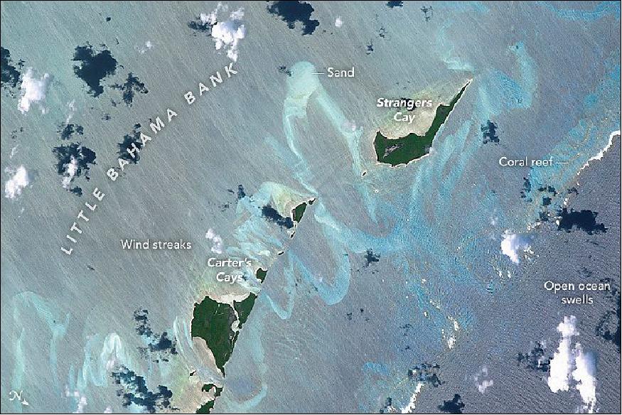
• October 24, 2016: Looking south to the horizon, an astronaut aboard the International Space Station (ISS) took this photograph of most of the Caspian Sea and neighboring countries in inner Asia. Shorelines of water bodies are key features for astronauts trying to orient themselves over Earth (Figure 79). 73)
- The south shore of the sea appears as a nearly straight line against the dark ranges of the Elburz Mountains of northern Iran. At a right-angled corner—a telltale feature of the Caspian Sea for astronauts looking down at Earth—the coastline veers due north, where it meets the 160 km-wide bay in Turkmenistan known as Kara-Bogaz Gol Basin (Zaliv Kara-Bogaz Gol). The narrow spit that divides this gulf from the Caspian Sea is another well-known feature. The saltwater Sarygamysh Lake lies on the Turkmenistan-Uzbekistan border, and the narrow Sor Kayduk channel in Kazakhstan shows its characteristic pink tone.
- The west side (right in this south-facing image) of the Caspian Sea lies under a thin smog layer, which partly obscures the finger of the Absheron Peninsula, the center of Azerbaijan's oil producing region.
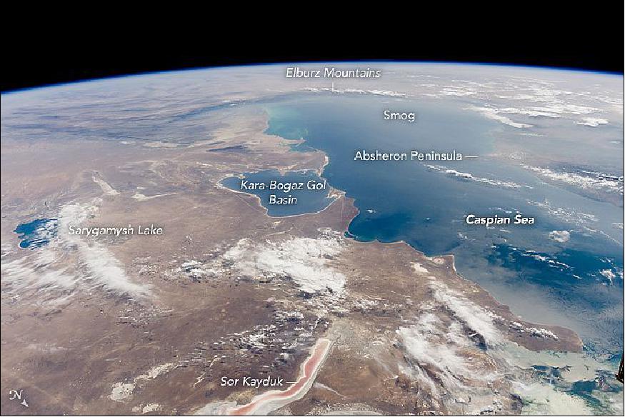
• October 17, 2016: The photograph of Figure 80, taken from the ISS, depicts the Greek Santorini islands in the Aegean Sea, arranged in an oval shape. They are all that remains of what was once a large, circular volcano. 74)
- The largest island in the ring is the tourist mecca of Santorini (also known as Thira), while the other islands are Thirasia and Aspronisi. The three pieces are what remains after an enormous eruption destroyed most of a volcanic island. Water from the Aegean Sea rushed in to fill the void, forming the central, 12 km long lagoon. The lagoon is surrounded by high, steep cliffs on three sides. Several towns occupy the top of these impressive, near-vertical cliffs (roughly 300 m, appearing as white stipple patterns from the traditional whitewash paint that is almost exclusively used on these islands.
- Santorini is one of the most famous tourist islands on Earth. Ships arrive at the bottom of the cliffs near the town of Fira. Tourists then climb a switchback road up the cliffs to the town—a classic Greek village on a cliff face looking out into the great lagoon. West of Fira, the water has a darker, ruffled texture from wind streaking across the lagoon on the downwind side of the islands. The wake of a boat also appears between Thirasia and Aspronisi.
- The caldera explosion that made this lagoon is one of the largest known to geologists. An estimated 100 km3 of material blew out of the volcano, four times as much as the well-recorded eruption by Krakatoa in 1883. Santorini has been designated a "Decade Volcano" because it poses more than one volcanic hazard to people living near it.
- The date of the Santorini explosion has been carefully researched and is now known to have taken place between 1600 and 1627 BCE (Before Common Era). Archaeological excavations at the town of Akrotiri are revealing exciting remains of a Minoan-age town with streets, three-story houses, and frescoes well preserved under ash layers, much like those preserved at Pompeii.
- Since the volcano is still active, the central peak has grown and then erupted repeatedly. Nea Kameni is the most recent peak of the underwater volcano to appear above water (popping up in 1707). There have been three eruptions in the twentieth century alone. Recent lava flows appear as dark-toned areas, compared with the lighter-toned surfaces of the older outer islands.
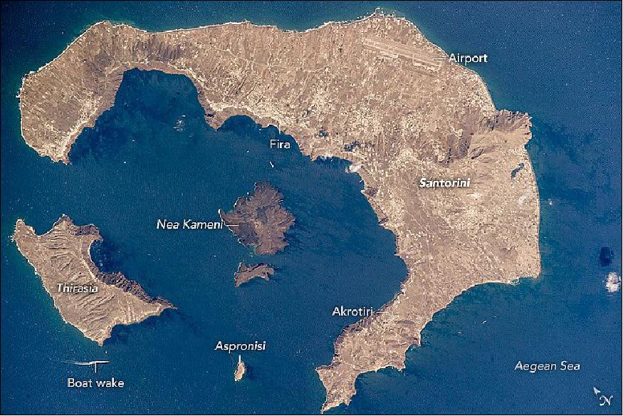
• Sept. 26, 2016: An astronaut aboard the International Space Station looked west from more than 700 km away and focused an 800 mm lens on the shorelines of Utah Lake and other water bodies in Utah (Figure 81). Shorelines are easy to see from space and often indicate interesting centers of human activity. 75)
- Utah Lake is so shallow that surface waves stir up light-toned muds from the bottom, giving the lake a light green-blue hue. Across the middle of the image, gray tones show the Provo-Orem metropolitan area that fringes the length of the lake, which is 33 km long. The lake's only outlet is the Jordan River (right), which leads water to the Great Salt Lake (at times when Utah Lake stands high).
- The Veterans Memorial Highway is a straight white line running through the metropolitan area from Provo to Lehi. Most of the green tones fringing the cities are farms that stretch right down to the water's edge. The lower part of the image shows the thickly wooded Wasatch Range, which rises so high above the city that it captures rain. Provo Peak and Mount Timpanogos are two well-known local peaks.
- Finding water for a population of 527,000 people and for local farming has always been problematic in Utah. Luckily snow and rainfall on the Wasatch Range nearby provide enough water—when there is careful conservation and reuse of water. The main water supply points are Utah Lake and rivers like the Provo, which cuts through the main Wasatch Range in a dramatic canyon. The Provo River connects to Deer Creek Reservoir on the east side of the mountains.
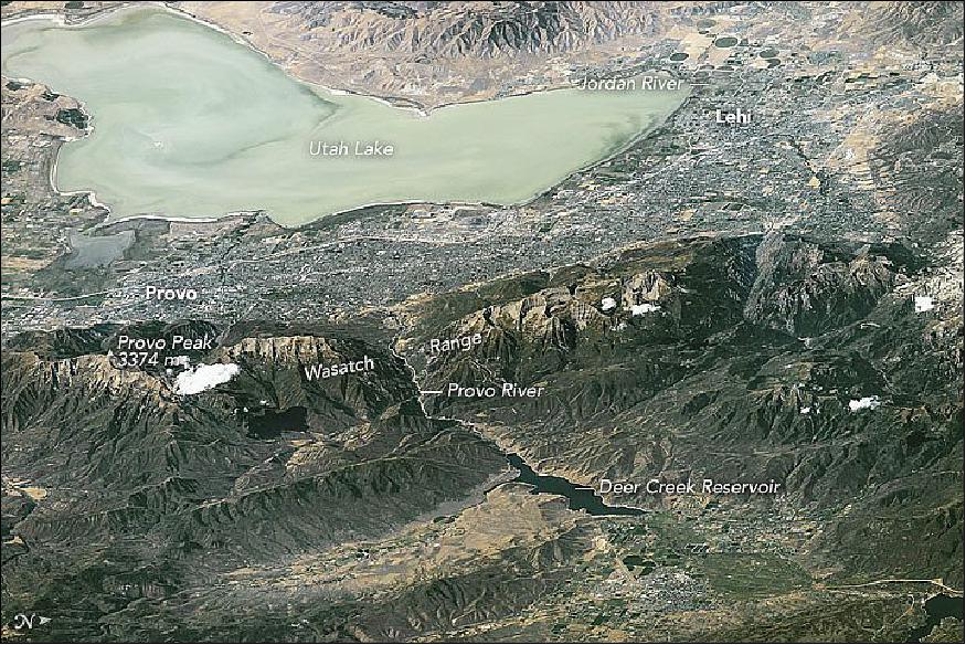
• August 29, 2016: While orbiting over the South China Sea, an astronaut aboard the ISS (International Space Station) took this oblique photograph of the blocky red and gray urban pattern of Manila and surrounding cities. Manila is sandwiched between the salt water of Manila Bay—with its scatter of anchored ships—and Laguna de Bay. The great docks at the port can be seen jutting into Manila Bay (image center left), while the heart of the city lies immediately inland of the port. A forested nature reserve with a lake is located within one of the mountainous areas surrounding the metro zone (top left). 76)
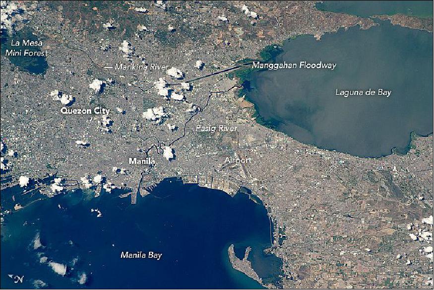
- The combined population of Manila and neighboring Quezon City is 4.7 million people. Manila itself has one of the highest population densities in the world, with 42,857 people per square kilometer. The metropolitan area is the political and economic hub of the Philippines, and its international trade connections are so widespread the Globalization and World Cities Research Network classed Manila as a global city. Manila's history has always been connected to trade. Arriving from Mexico, the conquistadors founded Manila in 1571, and soon the city became the Far East anchor of the Acapulco-Manila Galleon trade route connecting Spanish America with Asia. This represents one of the earliest examples of globalization.
- The dark lines of several waterways are prominent amidst the gray cityscape. The Pasig River winds through the middle of the city. The straight line of the Manggahan Floodway is a flood-control channel engineered to divert water from the Marikina River away from the city center and into Laguna de Bay. Engineering works along the floodway also control tidal saltwater flow into Laguna de Bay.
• July 25, 2016: An astronaut aboard the ISS (International Space Station) used the highest power lens available to document the complex patterns around Cape Coral, a master-planned city born in 1957. The development is a hub of the Fort Myers metropolitan area—one of the youngest cities in the United States and home to 680,000 people (Figure 83). 77)
- Cape Coral is also known to some as the "Waterfront Wonderland." Many of the dark lines through this development on the Gulf of Mexico are not streets but a vast network of constructed canals totaling more than 640 km — perhaps the longest canal shoreline in the world. The canal system is so extensive that local ecology and tides have been affected.
- Boat wakes (image center) appear as thin white lines on the wide Caloosahatchee River, which separates Cape Coral from Iona. The Caloosahatchee has been extensively engineered to assist river traffic. One such channel is the straight line (top left) cutting through the small islands, or keys. The 1,000 m long Cape Coral Bridge (lower right) was opened in early 1964, just a few years after the founding of the city. The bridge significantly reduces travel times to the cities of Iona and Fort Myers on the opposite side of the river. Another bridge (on the left) leads to Sanibel Island, a popular tourist destination.
- Many of the shorelines are extensively covered by mangrove wetlands. Several areas in the region are protected, partly because mangroves protect coastlines against erosion. Manatees abound in the waters of Florida, and a wildlife refuge for manatees has been established on San Carlos Bay.
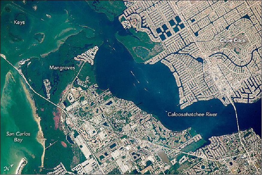
• June 27, 2016: From a distance of 700 km over the Pacific Ocean, an astronaut aboard the ISS captured this oblique image of a part of the Andes Mountains (Figure 84) . The mountain range crosses the entire image and forms the border between Chile and Argentina's wine country . 78)
- This view is notable because it reveals the canyons and valleys followed by the Pan-American Highway. The spacecraft and Sun were in just the right positions for the Sun's reflection to illuminate the thin rivers that run through the same deep valley that contains the highway. This pass through the Andes is the main route between Chile's capital, Santiago, whose outskirts appear in the lower right of the image, and Mendoza, the heart of Argentina's wine making industry.
- The highway route over the Andes starts just north of Chile's capital city Santiago at the small town of Los Andes and snakes its way up the forested Juncal River valley, where it passes close to Aconcagua, the highest mountain in the Western Hemisphere (6959 m). Near Aconcagua, the highway crosses the international boundary into the Mendoza River valley and passes through a high, treeless desert valley. Then the highway bends southeast and descends to the Mendoza basin, marked here by a blanket of haze. Haze, a variable mix of smoke, dust, and fog, is a typical winter phenomenon on windless days, as seen also in the basins in Chile where Santiago and Los Andes are located.
- The Pan-American Highway is an almost continuous road, 30,000 km long, that joins seventeen countries in the Americas, from southernmost South America up through North America to the Arctic Ocean.
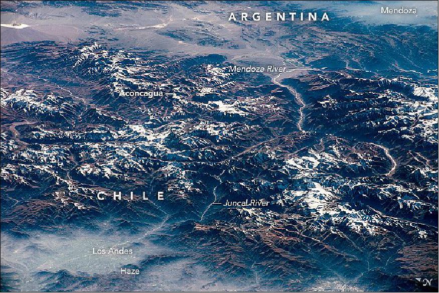
• June 20, 2016: Scanning the monotonous, tan-colored surface of the Sahara Desert, an astronaut aboard the International Space Station saw small, dark patches next to a long, ragged cliff in Egypt's Western Desert. The dark patches are date and olive groves in the Bahariya Oasis (population 27,000), one of several small places in Egypt's deserts where people can live. The town of Bawiti, where most people live, is harder to detect (Figure 85). 79)
- The steep cliffs surround a depression in the desert surface, at the bottom of which lies a small lake. The depression is punctuated by a flat-topped hill (mesa) surrounded by lower cliffs. Bahariya is one of several large depressions west of the Nile that are deep enough to reach underground water.
- The oasis has a rich history, going back at least to Egypt's Middle Kingdom (2000-1800 BCE), when agricultural products from the oasis were exported to the Nile Valley. Alexander the Great may have passed through this oasis, even though it is so remote (380 km southwest of Cairo). The Valley of the Golden Mummies in Bahariya purportedly holds as many as 10,000 undisturbed mummies of Roman and Greek aristocrats, dating from 332 B.C.E. to 395 A.D. Aqueducts built by the Roman Empire are still used today to carry water to groves and farms.
- In recent years, a new road between Bahariya and Cairo has brought significant traffic in tourists coming to see the remnants of ancient life. A nearby iron mine also supports many people from Bahariya.
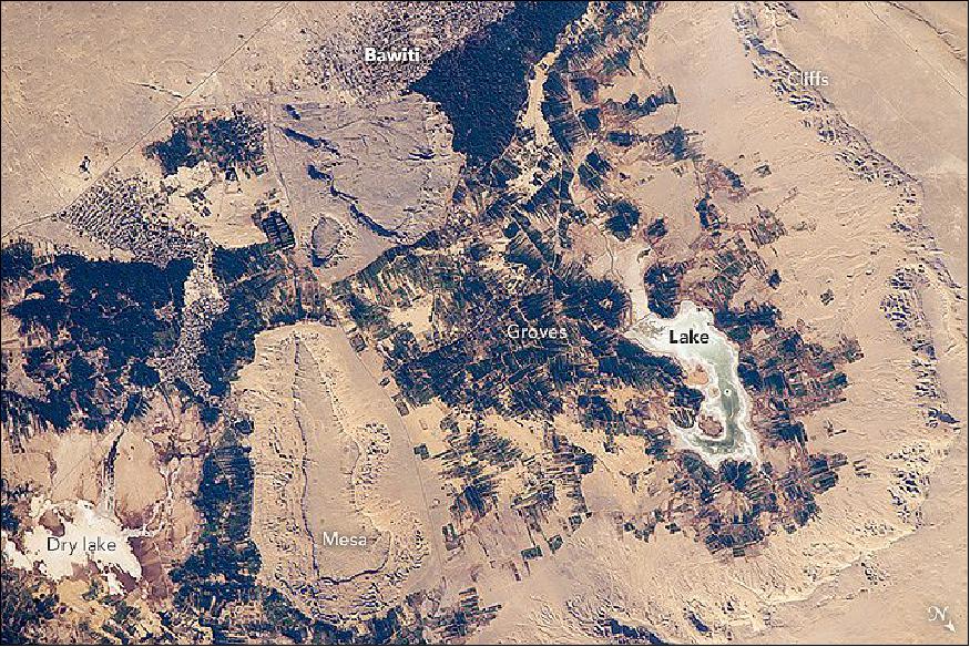
• June 13, 2016: In orbit above the semi-desert grasslands in Kazakhstan, an astronaut aboard the International Space Station spotted one of the few features that stand out. Lake Tengiz is the only large lake (1590 km2) in northern Kazakhstan. Through white wisps of cloud, the crew member photographed the 50 km long eastern shore of the lake, with its thin, winding islands and white beaches (Figure 86). 80)
- The islands and intervening waterways make a rich habitat for birds in this part of Asia. At least 318 species of birds have been identified at the lake; 22 of them are endangered. It is the northernmost habitat of the pink flamingo. The lake system is Kazakhstan's first UNESCO World Heritage Site, and it has been declared a RAMSAR wetland site of international importance.
- Part of the richness of area is its complex hydrology. Fresh water enters the system via the Kulanutpes River, so there are small lakes (lower right) full of fresh water. But in this closed basin, the water in the main lake (top) slowly evaporates, becoming salty. Winds stir up bigger waves on the main lake, dispersing sediment and salt and making the water a cloudier and lighter blue-green.
- The strange shape of the islands is not easy to interpret. They may be drowned remnants of delta distributaries of the Kulanutpes River. Westerly winds probably have had a smoothing effect on the shorelines, especially in a shallow lake like Tengiz, which is only about 6 m deep.
- The lake has an exciting history for people who follow space exploration. In 1976, a Soyuz spacecraft landed in the lake near the north shore (top right). The capsule crashed through the ice and sank during an October snowstorm when temperatures were -22°C. Because of low power, the capsule was unheated and the crew was feared lost. It was many hours before the airtight capsule was located and divers could attach flotation tanks to get the capsule to the surface. It was then dragged ashore across the ice by helicopter. The rescue effort took nine hours before the crew was able to safely exit the capsule.
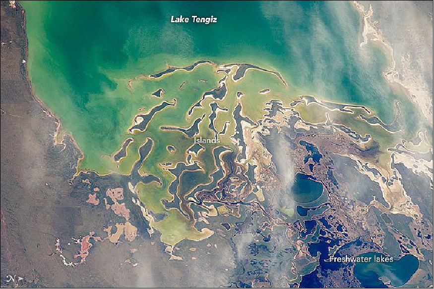
• May 31,2016: An astronaut aboard the International Space Station used a powerful lens to photograph these three reefs in Australia's Great Barrier Reef (Figure 87). The photo area spans about 15 km of the 2300 km reef system. Reefs are easy to spot from space because the iridescent blues of shallow lagoons contrast sharply with the dark blues of deep water. 81)
- The Great Barrier Reef is the largest reef system on Earth, with more than 3,000 separate reefs and coral cays. It is also one of the most complex natural ecosystems, with 600 types of corals and thousands of animal species from tiny planktons to whales. Corals look like plants, but are in fact colonies of very small animals known as coral polyps—closely related to jellyfish. The color differences in the photo relate to different habitats for coral growth; that is, the habitats strongly relate to two sources of energy and nutrients.
- Agitated water—as in the surface zone, where waves break against the reef—provides more plankton nutrients than still water, especially for reefs like these that lie far from land sources of nutrients (75 km from the Queensland coastline). The best-developed reef crests face the open ocean (image right) for this reason. The dark, narrow channels between the lagoons also allow deeper, nutrient-rich water to reach the reef-crest corals. But waves are also destructive, so only robust types of coral live within the breaker zone.
- The other source of energy is the Sun, which is needed by symbiotic, single-cell organisms that provide most of the nutrients for coral growth. The dark blues in the image are zones where too little light penetrates the water. Tropical corals disappear where the light fades away: about 60 m below the sea surface. By contrast, the shallow water within the lagoons has the strongest light supply and displays numerous patches of coral. Although lagoons are protected from the full force of waves, they lack the plankton supply from constant wave agitation. This limits the amount of living coral within the lagoon, as seen in the empty zones. But the lagoons have so many microhabitats that they boast the greatest number of species in the reef ecosystem—with mollusks, worms, and crustaceans often dominating the visible fauna.
- The Great Barrier Reef is now protected in a marine park. The three reefs captured here — part of the planning area for the Whitsunday group of islands, which are 900 km north of Brisbane in Queensland — have different types of protected status. The reef at top left is a habitat protection zone, controlling potentially damaging activities such as trawling. The reef on the lower left is a conservation park, which has limited fishing. The reef at the center of the image is a marine national park, with no fishing or collecting.
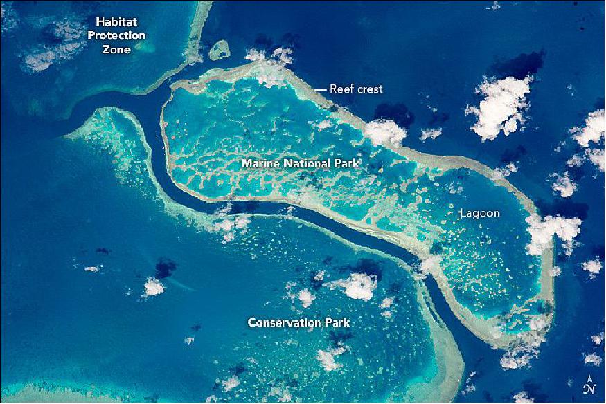
• May 16, 2016: Astronauts aboard the ISS (International Space Station) see the world at night on every orbit —that's 16 times each crew day. An astronaut took this broad, short-lens photograph of Earth's night lights (Figure ) while looking out over the remote reaches of the central equatorial Pacific Ocean. ISS was passing over the island nation of Kiribati at the time, about 2600 km south of Hawaii. 82)
- Knowing the exact time and the location of the ISS, scientists were able to match the star field in the photo to charts describing which stars should have been visible at that moment. They identified the pattern of stars in the photo as our Milky Way galaxy (looking toward its center). The dark patches are dense dust clouds in an inner spiral arm of our galaxy; such clouds can block our view of stars toward the center.
- The curvature of the Earth crosses the center of the image and is illuminated by a variety of airglow layers in orange, green, and red. Setting stars are visible even through the dense orange-green airglow.
- The brightest light in the image is a lightning flash that illuminated a large mass of clouds. The flash reflected off the shiny solar arrays of the ISS and back to the camera. The dim equatorial cloud sheet is so extensive that it covers most of the sea surface in this view.
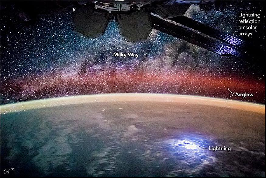
• On May 17, 2016, ESA astronaut Tim Peake took this picture (Figure 89) from the International Space Station and commented: "Today the International Space Station completed its 100 000th orbit of our beautiful planet Earth! An amazing feat of science, engineering and international cooperation – congratulations Space Station." 83)
- The odometer was set when the first module, Zarya, was launched on 20 November 1998. Each orbit takes around 90 minutes to complete, but relative to Earth, the Station moves to the west by around 2200 km each time.
- Europe's Columbus module was added to the complex in 2008 and passed its own milestone last month: 26 April 2016 marked its 3000th day of operation in space. The Solar facility on Columbus has been observing the Sun for most of these 3000 days, tracking our star's output to help understand its influence on our climate.
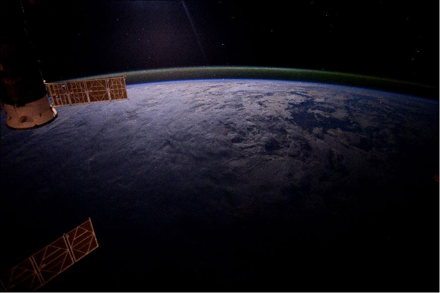
• May 13, 2016: The Expedition 47 crew poses for the 3 millionth image taken aboard the International Space Station. For more than 15 years, station crews have been taking photographs of the Earth and inside activities. In the photo: (front row from the left) ESA (European Space Agency) astronaut Timothy Peake, NASA astronaut Timothy Kopra and Roscosmos cosmonaut Yuri Malenchenko. (back row from left) Russian cosmonauts Oleg Skripochka and Alexey Ovchinin along with NASA astronaut Jeff Williams. 84)
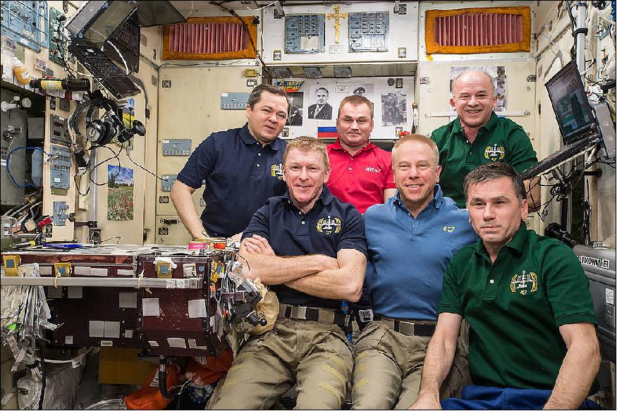
• May 9, 2016: An astronaut aboard the ISS (International Space Station), a member of the Expedition 46 crew, shot the image of Figure 91, in recognizing an unusual river that vanishes in a sand field well before it reaches the sea. The Hamra River (As Saquia al Hamra in Arabic) ends about 15 km from the Atlantic Ocean in a dark blue lake. The river has cut into the landscape, making low cliffs on both sides. The river has its source in the mountains 300 km inland, and it provides a persistent water supply for El Aaiún, the biggest city in Western Sahara. The country 'Western Sahara' is a disputed territory ( 266,000 km2) in the Maghreb region of North Africa, bordered by Morocco to the north, Algeria to the northeast, Mauritania to the east and south, and the Atlantic Ocean to the west. One of the most sparsely populated countries in the world, Western Sahara has a population of nearly half a million people; nearly 40% of them live in El Aaiún. 85)
• April 4, 2016: Looking almost straight down onto the Sahara Desert, a crew member aboard the International Space Station took this late afternoon photograph of the Grand Erg Oriental. Astronauts have a unique vantage point from which to view the large areas of Algeria and Libya covered by seas of sand. 86)
- Winds have organized vast quantities of sand into straight lines in what geologists call "compound linear chains." The chains are about 1.5 km wide in this view and rise 150 m above the smooth, intervening flats. The compound chains are made up of numerous smaller linear dunes with sharply defined crests (also known as seif dunes, after the Arabic word for sword). Linear dunes sometimes converge to a point with long tentacle-like arms called star dunes. An astronaut snapped a photo of individual, well-developed star dunes just 20 seconds after this photo was taken (Figure 94).
- Geologists now know that different wind patterns are responsible for different dune shapes. Winds that blow from one direction build linear dunes and, ultimately, chains like those in this image. The slight variation in wind direction pushes sand from one side of the dune and then from the other, making the sharp crests of the small linear dunes. These winds also stretch out the dune in the average direction of the winds (southward in this part of Algeria).
- By contrast, winds that blow with roughly equal strength from several directions make the star dunes. This suggests that the wind regime changed with time, first building the chains over a long period of time, and then becoming more multidirectional, so that the star dunes formed on top of the chains.
- Transverse dunes form at right angles to the wind direction. Relatively small transverse dunes can be seen at many points in this image. They were made by north winds channeled by the chains, especially along the outer flanks and in hollows within the chains.
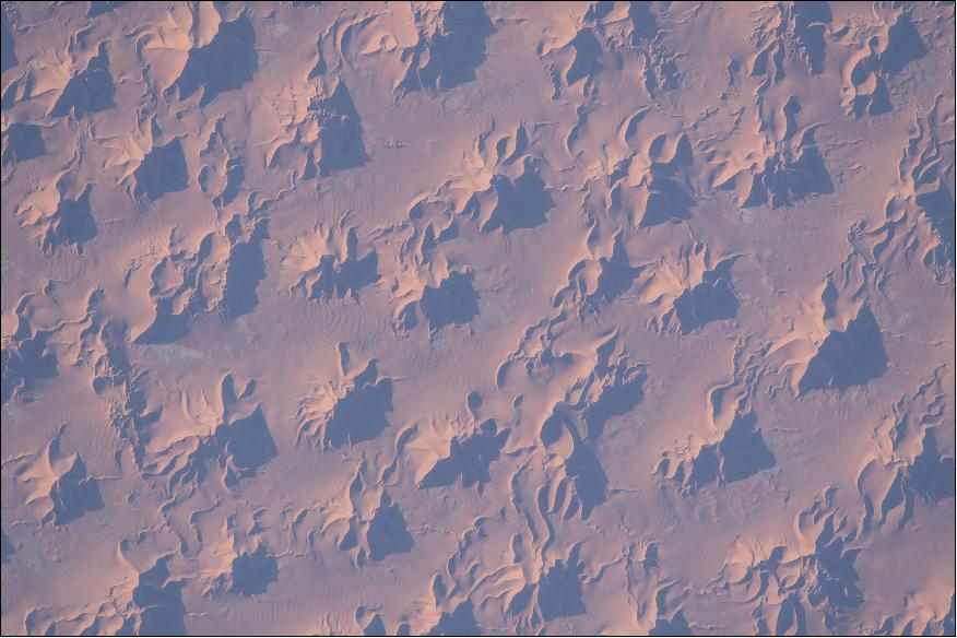
• March 30, 2016: ESA astronaut Tim Peake photographed the iceberg in the Antarctic Sea (Figure 95) from the ISS and downlinked the image to ESA. In response, the ESA team tracked down the iceberg with the help of Leif Toudal from the Danish Meteorological Institute, ably assisted by Europe's Sentinel-1A radar satellite and NASA's Aqua satellite, both flying well above the Space Station at roughly 700 km. 88)
- Thanks to Leif and his spaceborne assistants, we now know that the iceberg in Tim's picture is "A56" and is around 26 km by 13 km, meaning it would fit inside London's Circular Road along its length with room to spare over its width. It has been estimated to be 30 m high, which means it could extend 270 m below the sea, considering most icebergs conceal 90% of their volume underwater.
- A56 originates from the Bellinghausen Sea and has been drifting around the area for at least nine months, slowly heading northeast into the Atlantic Ocean, floating more than 1500 km since July 2015. It is now off the coast of the South Georgia and the South Sandwich Islands.
- The International Space Station's orbit of 56.2 º inclination offers no clear view of Antarctica and a picture of an iceberg taken by an astronaut in space is a rare occurrence. Sentinel-1, however, is designed for continuous monitoring of sea ice and icebergs in the polar regions. Its advanced radar provides images regardless of weather or darkness, making it an invaluable tool for monitoring our environment and supporting ship navigation through these treacherous waters. View the very same A56 iceberg as seen by Sentinel-1A's radar on 23 July 2015 in the image of Figure 96.
• March 28, 2016: Astronauts need oblique views and low sun angles to get a strong sense three dimensions when they take photographs from the International Space Station. This photo of Figure 97 was taken with the most powerful lens presently on board. The low afternoon sun emphasizes the conical shape of Japan's most famous volcano, Mount Fuji. Other details enhance the sense of topography in the image, including numerous gullies in the flanks, as well as shadows cast in the summit- and side crater (Hoeia). 89)
- From orbit, even the highest mountains can look flat if the astronaut looks straight down and if the sun is high—a strange sensation for humans who know mountains from a ground-level standpoint. Figure 98 shows a slightly less detailed image of Mount Fuji, taken with an 800 mm lens when the sun was at a higher angle.
- Mount Fuji is one of Japan's most striking symbols, and tourism in the area is highly developed. The switchbacks of a climbing toll road can be seen clearly on the upper center margin of the image (Figure 97). As a satisfyingly symmetrical peak, Fuji is extensively photographed. As the highest peak in Japan (3776 meters or 12,389 feet), it is visible from great distances with a brilliant snow cap for many months of the year. Mount Fuji has great cultural importance in Japan as a hallowed mountain in the Shinto religion. Pilgrims have climbed the mountain as a devotional practice for centuries, and many shrines dot the landscape around the volcano, and are even located within the summit crater. For this reason, Mount Fuji is now a UNESCO World Heritage Cultural Site.
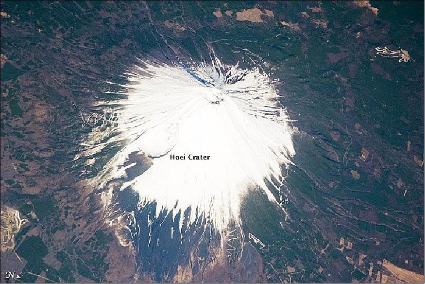
• March 9, 2016: ESA astronaut Tim Peake took this image (Figure 99) circling Earth 400 km up in the International Space Station. He commented: "Sometimes looking down on Earth at night can be kinda spooky." Astronauts often spot thunderstorms and are impressed by how much lightning they observe. 90)
- Although this picture was taken in Tim's free time, the Station is used for research into elusive phenomena in the upper atmosphere during thunderstorms – red sprites, blue jets and elves. Some of the most violent electric discharges are very difficult to capture from the ground because of the atmosphere's blocking effect. From space, astronauts can judge for themselves where to aim the camera, where to zoom in and follow interesting regions for researchers.
• March 2, 2016: NASA astronaut and Expedition 46 Commander Scott Kelly and his Russian counterpart Mikhail Kornienko returned to Earth Tuesday after a historic 340-day mission aboard the International Space Station. They landed in Kazakhstan at 4:26 UTC on March 2. — Joining their return trip aboard a Soyuz TMA-18M spacecraft was Sergey Volkov, also of the Russian space agency Roscosmos, who arrived on the station Sept. 4, 2015. The crew touched down southeast of the remote town of Dzhezkazgan. 91)
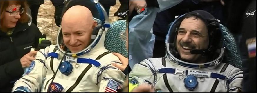
- "Scott Kelly's one-year mission aboard the International Space Station has helped to advance deep space exploration and America's Journey to Mars," said NASA Administrator Charles Bolden. "Scott has become the first American astronaut to spend a year in space, and in so doing, helped us take one giant leap toward putting boots on Mars."
- During the record-setting One-Year mission, the station crew conducted almost 400 investigations to advance NASA's mission and benefit all of humanity. Kelly and Kornienko specifically participated in a number of studies to inform NASA's Journey to Mars, including research into how the human body adjusts to weightlessness, isolation, radiation and the stress of long-duration spaceflight. Kelly's identical twin brother, former NASA astronaut Mark Kelly, participated in parallel twin studies on Earth to help scientists compare the effects of space on the body and mind down to the cellular level.
- One particular research project examined fluid shifts that occur when bodily fluids move into the upper body during weightlessness. These shifts may be associated with visual changes and a possible increase in intracranial pressure, which are significant challenges that must be understood before humans expand exploration beyond Earth's orbit. The study uses the Russian Chibis device to draw fluids back into the legs while the subject's eyes are measured to track any changes. NASA and Roscosmos already are looking at continuing the Fluid Shifts investigation with future space station crews.
- Including crew mate Gennady Padalka, with whom Kelly and Kornienko launched on March 27, 2015, 10 astronauts and cosmonauts representing six different nations (the United States, Russia, Japan, Denmark, Kazakhstan and England) lived aboard the space station during the yearlong mission.
- With the end of this mission, Kelly now has spent 520 days in space, the most among U.S. astronauts. Kornienko has accumulated 516 days across two flights, and Volkov has 548 days on three flights.
- Expedition 47 continues operating the station, with NASA astronaut Tim Kopra in command. Kopra, Tim Peake of ESA (European Space Agency) and Yuri Malenchenko of Roscosmos will operate the station until the arrival of three new crew members in about two weeks. NASA astronaut Jeff Williams and Russian cosmonauts Alexey Ovchinin and Oleg Skripochka are scheduled to launch from Baikonur, Kazakhstan, on March 18, 2016.
• Feb. 29, 2016: Figure 101 is an astronaut photo of the Crimean Peninsula that juts into the Black Sea. A mild climate has made Crimea a popular destination for Ukrainians and Russians from colder climes to the north. 92)
- A series of shallow lagoons and wetlands known as the Sivash separates the peninsula from the mainland. At no more than 3 meters deep, these lagoons warm up in the summer and become quite salty due to evaporation. The waters farthest inland from the Sea of Azov tend to develop different colors as a result of the salt-tolerant algae that live in them. These western Sivash lagoons make a unique landscape that immediately indicates to astronauts that they are above Crimea.
- Crimea is a small part of the world (325 km in the east-west direction) but one that has acquired fame over the centuries. Sevastopol saw heavy fighting between the Russians and Germans in World War II, and Yalta is the city where Allied leaders met for their famous conference to discuss post-war arrangements. Balaklava, near Sevastopol, became famous during the Crimean War of the 1850's for the Charge of the Light Brigade—and for the head and neck garment first worn there by soldiers. Sevastopol is also the home port of Russia's Black Sea Fleet.
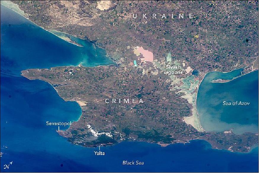
• February 26, 2016: The stellar views from the International Space Station are not the only things to take an astronaut's breath away: devices like this are measuring astronauts' breath to determine the health of their lungs. ESA astronaut Tim Peake took part in the Airway Monitoring experiment during his Principia mission in 2016. 93)
- Developed by researchers at the Karolinska Institute in Sweden, the experiment draws on a study of airway inflammation that ran on the Station from 2005 to 2008.
- The analyzer measures the amount of nitric oxide in exhaled air – a signalling molecule produced in the lungs to help regulate blood vessels. Too much nitric oxide suggests inflammation. Causes can be environmental, like dust or pollutants, or biological, such as asthma – at least on Earth, but what happens in space?
- Researchers compare measurements from astronauts taken before their flights to those taken in space to understand the effects of weightlessness on airway health. Astronauts in space are essentially fish out of water. Understanding how to track, diagnose and treat lung inflammations is important for their safety.
- The experiment began with ESA astronaut Samantha Cristofretti's 2015 mission and measurements have been gathered by six astronauts. Four more astronauts will conduct the experiment next year.
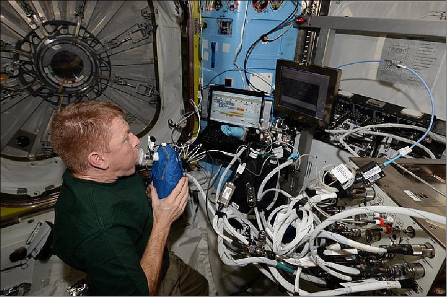
• Feb. 18, 2016: Nearing the final days of his history making one-year-long sojourn in orbit, space farming NASA astronaut Scott Kelly harvested the first ever crop of ‘Space Zinnias' grown aboard the ISS on a most appropriate day – Valentine's Day, Sunday, Feb. 14, 2016. 94)
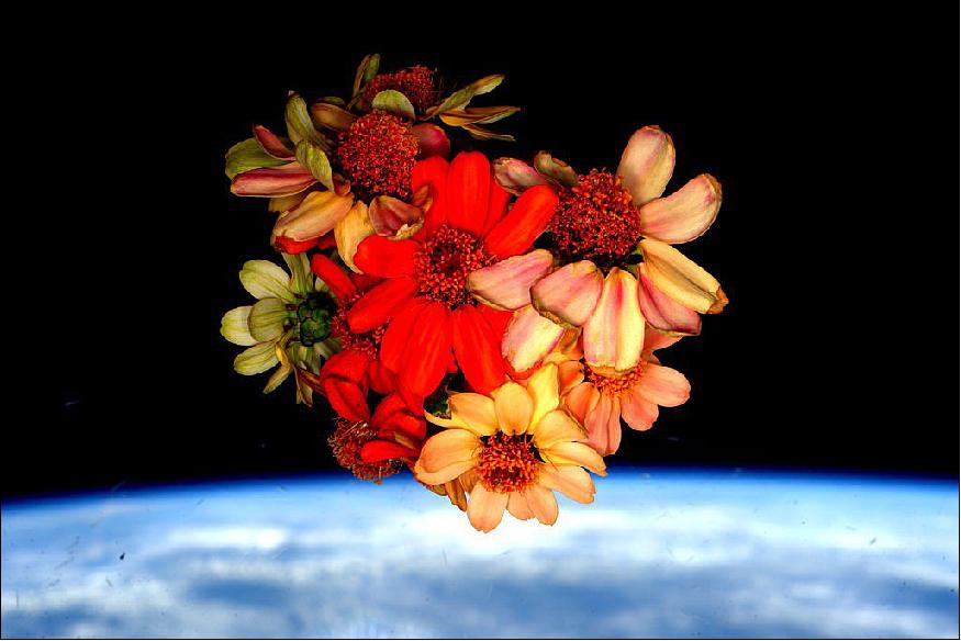
- After enduring an unexpected series of trial and tribulations – including a fearsome attack of ‘space mold' – Kelly summoned his inner ‘Mark Watney' and brought the Zinnia's to life, blossoming in full color and drenched in natural sunlight (Figure 103). He spent weeks lovingly nursing the near dead plants back to health and proudly displayed the fruits of his blooming labor through the windows of the domed Cupola, jutting out from the orbiting outpost and dramatically back dropped by the blue waters of Earth and the blackness of space.
- "Nursed the #SpaceFlowers all the way to today and now all that remains are memories," tweeted NASA astronaut and Expedition 46 Commander Scott Kelly on Feb 14, 2016. — "Happy #Valentines Day!"
- The zinnias are thus contributing invaluable experience to scientists and astronauts learning how to grow plants and food in microgravity during future deep space human expeditions planned for NASA's "Journey to Mars" initiative. The experimental Space Zinnias are truly an important part of NASA's ongoing crop research activities and are being grown in the stations Veggie plant growth facility.
- But it wasn't always looking so rosy for the zinnias. Just before Christmas, Kelly found that these same Zinnias were suffering from a serious case of space blight when he discovered traces of mold on the flowers growing inside Veggie (see Figure 108).
- Kelly asked to be given decision making power and was assigned as an "autonomous gardener," Gioia Massa, NASA Kennedy payload scientist for Veggie, explained to Universe Today during a visit to the Veggie ground control experiment facility at NASA/KSC (Kennedy Space Center) in Florida (Figure 104).
- Ever since then, the space stations zinnias have been on the rebound. "I think we've learned a lot about doing this kind of experiment. We're being farmers in space," Kelly explained before the harvest. "I was extra motivated to bring the plants back to life. I'm going to harvest them on Valentine's Day."
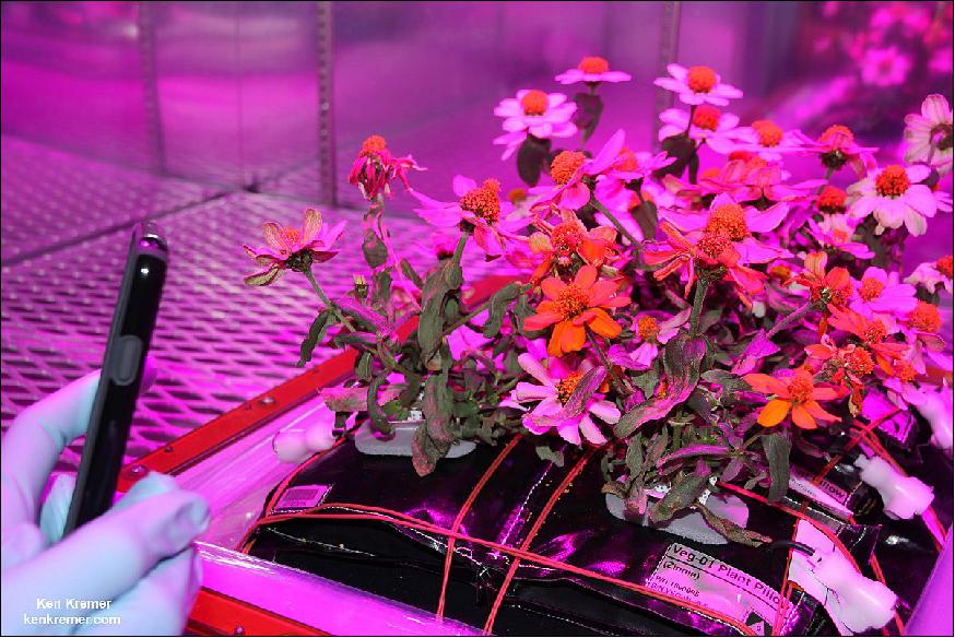
- Meanwhile back on Earth, scientists harvested the counterpart ‘ground truth' Zinnia's being grown at Veggie ground control in the Space Station Processing Facility at KSC on Feb. 11, the same way they are being grown and harvested on the ISS.
- The team will compare and contrast the results of the ground and space grown zinnias in designing future space farming experiments.
- Kelly's space farming success comes just in the nick of time, as he is now less than two weeks away from the culmination of his ‘1 Year in Space' mission aboard the ISS. Kelly is the first American to spend a year in space. And he comprises one half of the first ever ‘1 Year ISS crew' – along with Russian cosmonaut Mikhail Kornienko.
- Kelly and Kornienko serve as human guinea pigs for studying the effects of long term spaceflight in zero gravity on the human body that will aid planning for sending people on years long expeditions to Mars. The dynamic duo and their four co-orbiting international crewmates are conducting hundreds of experiments aimed at paving the path for the eventual multi-year expeditions to the Red Planet (Ref 94).
• February 2, 2016: ESA astronaut Tim Peake took this image of London, UK, from the International Space Station 400 km above Earth. At the time it was midnight in the capital city and, because the Space Station runs on Greenwich Mean Time, it was also the same time for Tim Peake. 95)
- The lights in the image are mainly street lighting, illuminating the streets of London. Lights appearing blue are LED-lit areas. Black areas in the picture correspond to unlit areas such as parks and rivers – the distinctive wind of the River Thames shows in black. Hyde Park, Regent's Park and Battersea Park are recognizable in the center, the reservoirs at Walthamstow are upper center, and Richmond Park is at lower left.
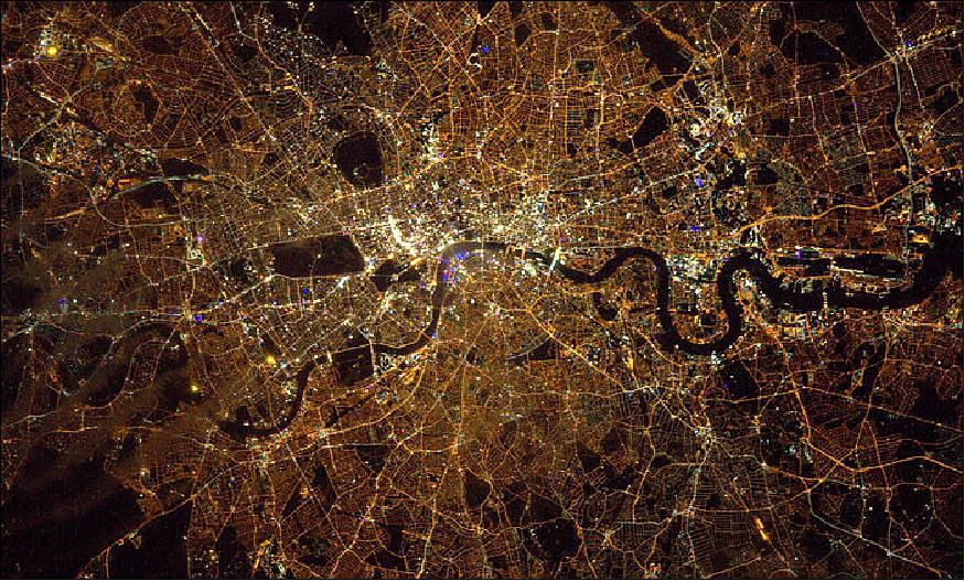
• January 20, 2016: ESA astronaut Tim Peake of the UK, NASA astronaut Tim Kopra and Russian cosmonaut commander Yuri Malenchenko arrived at the International Space Station on Dec. 15, 2015, six hours after their launch in the Soyuz TMA-19M spacecraft from the Baikonur Cosmodrome. This marks the start of Tim's six-month Principia mission. 96)
- After a few busy weeks, Tim posted a series of aurora photos onto his flickr website (https://www.flickr.com/photos/timpeake) . The image of Figure 107, labeled "magical aurora", is one of Tim's photo series. 97)
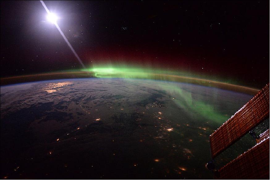
• January 20, 2016: The first Zinnia flower to bloom in space is dramatically catching the sun's rays like we have never seen before – through the windows of the Cupola on the ISS while simultaneously providing a splash of soothing color, nature and reminders of home to the multinational crew living and working on the orbital science laboratory. 98)
- Furthermore its contributing invaluable experience to scientists and astronauts on learning how to grow plants and food in microgravity during future deep space human expeditions planned for NASA's "Journey to Mars" initiative.
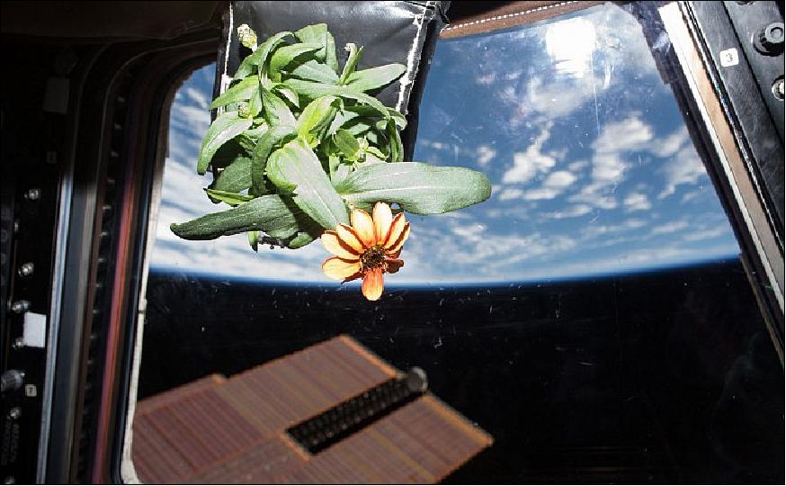
- NASA astronaut and Expedition 46 Commander Scott Kelly is proudly sharing stunning new photos showing off his space grown Zinnias – which bloomed for the first time on Jan. 16, all thanks to his experienced green thumb.
- Whereas the Zinnia plants are normally bathed with red, green and blue LED lighting in the chamber, Kelly decided to further nurture the plants with some all natural sunlight from our life giving sun. The Veggie experiment is comprised of "pillows" holding the Zinnia flower seedlings that provide nutrients to the plants root system inside the experimental and low-cost illuminated growth chamber.
- The Veggie plant growth facility was installed on the orbiting laboratory in early May of 2014, and the first crop – ‘Outredgrous' red romaine lettuce – was activated for growth. The first growth cycle faced some issues. "We lost two plants due to drought stress in the first grow out and thus were very vigilant with respect to the second crop," said Trent Smith, Veggie project manager. 99)
- The second crop of the same lettuce was activated in early July 2015 by NASA astronaut Scott Kelly, and thanks to lessons learned from the first run, adjustments to watering and collecting imagery of the plants were made. The leafy greens grew according to schedule, with only one plant pillow not producing. This time the crew was able to eat the lettuce when it was ready to be harvested a month later.
- Veggie will remain on the station permanently and could become a research platform for other top-growing plant experiments. ORBITEC developed Veggie through a Small Business Innovative Research Program. NASA and ORBITEC engineers and collaborators at Kennedy worked to get the unit's hardware flight-certified for use on the space station.
- The next crop on the docket was a batch of zinnia flowers, but they weren't selected for their beauty. They were chosen because they can help scientists understand how plants flower and grow in microgravity. "The zinnia plant is very different from lettuce, said Trent Smith, Veggie project manager. "It is more sensitive to environmental parameters and light characteristics. It has a longer growth duration between 60 and 80 days. Thus, it is a more difficult plant to grow, and allowing it to flower, along with the longer growth duration, makes it a good precursor to a tomato plant.
- When Scott Kelly tweeted a picture of moldy leaves on the current crop of zinnia flowers aboard the ISS, it could have looked like the science was doomed. In fact, science was blooming stronger than ever. What may seem like a failure in systems is actually an exceptional opportunity for scientists back on Earth to better understand how plants grow in microgravity, and for astronauts to practice doing what they'll be tasked with on a deep space mission: autonomous gardening.
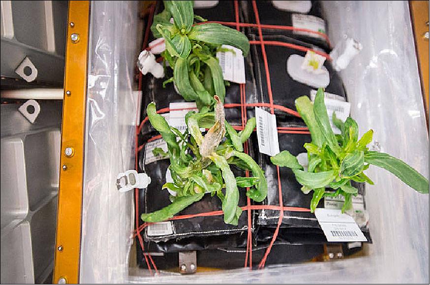
- The survival of the Zinnias is a direct result of Kelly requesting permission to take personal change of caring for the plants without having to constantly ask Mission Control for pages and pages of detailed instructions and direction. Thus after Christmas he was liberated to act on his own discretion and christened as "an autonomous gardener." The Zinnias have been on the rebound ever since and the proof is in the blooming.
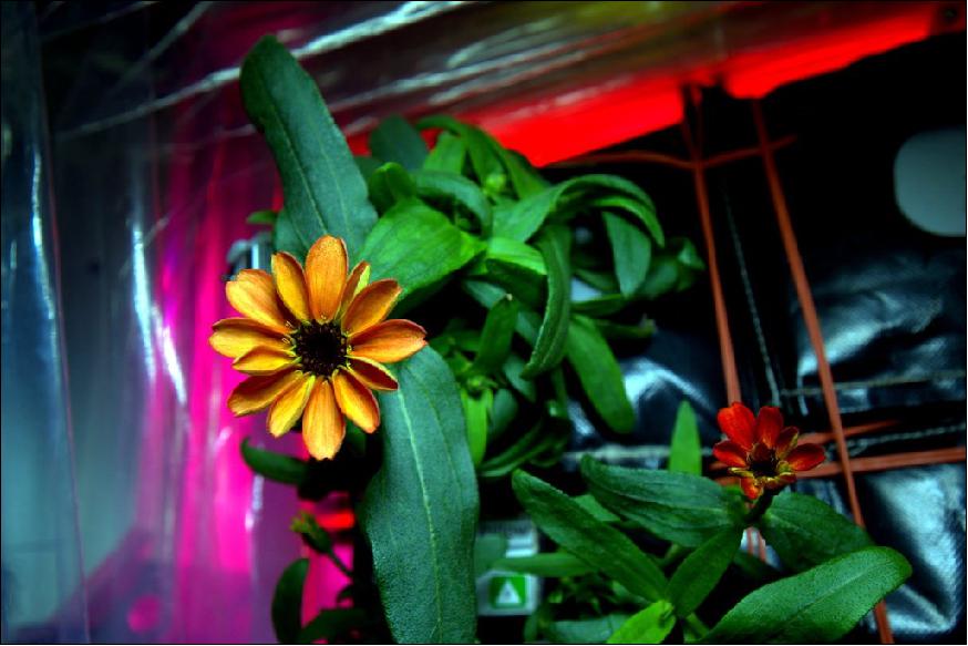
Figure 110: The Zinnia flower blooms in space for the first time in the Veggie growth facility aboard the International Space Station on Jan. 16, 2016 (image credit: NASA, Scott Kelly, Ref. 98)
References
1) "Coastal Spit, Lake Erie," NASA Earth Observatory, 23 Dec. 2017, URL: https://earthobservatory.nasa.gov/IOTD/view.php?id=91485
2) "Paolo thumbs up," ESA, 14. Dec. 2017, URL: http://m.esa.int/spaceinimages/Images/2017/12/Paolo_thumbs_up
3) "NASA Astronaut Bresnik and Crewmates Return to Earth From Space Station," NASA Release 17-099, 14 Dec. 2017, URL: https://www.nasa.gov/press-release/nasa-astronaut-bresnik-and-
crewmates-return-to-earth-from-space-station
4) "Soyuz MS-05 crew," ESA, 12 Dec. 2017, URL: http://m.esa.int/spaceinimages/Images/2017/12/Soyuz_MS-05_crew
5) "Health check for Paolo Nespoli using Tempus Pro," ESA, 22 Dec. 2017, URL: http://m.esa.int/spaceinimages/Images/2017/12/Health
_check_for_Paolo_Nespoli_using_Tempus_Pro
6) "Night Lights of the Levant," NASA Earth Observatory, 11 Dec. 2017, URL: https://earthobservatory.nasa.gov/IOTD/view.php?id=91409&src=iotdrss
7) "Paolo in BEAM," ESA, Human Spaceflight image of the week, 5 Dec. 2017, URL: http://m.esa.int/spaceinimages/Images/2017/12/Paolo_in_BEAM
8) "Agricultural Fields and Flat Lands, Brazil," NASA Earth Observatory, 4 Dec. 2017, URL: https://earthobservatory.nasa.gov/IOTD/view.php?id=91360&src=iotdrss
9) Mark Garcia, "Astronauts Take on Science, Plumbing and Cargo Duties Today," NASA, 16 Nov. 2017, URL: https://blogs.nasa.gov/spacestation/2017/11/16/astronauts-take
-on-science-plumbing-and-cargo-duties-today/
10) "Salt Glacier, Zagros Mountains," NASA Earth Observatory, 13 Nov. 2017, URL: https://earthobservatory.nasa.gov/IOTD/view.php?id=91264
11) "Look at the Moon, Human Spaceflight image of the week: ESA astronaut Paolo Nespoli's room with an atypical view," ESA, 9.Nov. 2017, URL: http://m.esa.int/spaceinimages/Images/2017/11/Look_at_the_Moon
12) "Stressed seedlings in space," ESA research human spaceflight and exploration, 7 Nov. 2017, URL: http://www.esa.int/Our_Activities/Human_Spaceflight/
Research/Stressed_seedlings_in_space
13) "Lake Hazlett and Lake Willis," NASA Earth Observatory, 30 October 2017, URL: https://earthobservatory.nasa.gov/IOTD/view.php?id=91189
14) "Mobile upgrade," ESA week in images, 24 Oct. 2017, URL: http://www.esa.int/spaceinimages/Images/2017/10/Mobile_upgrade
15) "Colorado River Agriculture," NASA Earth Observatory, 23 Oct. 2017, URL: https://earthobservatory.nasa.gov/IOTD/view.php?id=91151&src=iotdrss
16) "Spacewalkers fix robotic arm in time to grab next cargo ship," Space Daily, 20 Oct. 2017, URL: http://www.spacedaily.com/reports/Spacewalkers_fix_
robotic_arm_in_time_to_grab_next_cargo_ship_999.html
17) "US astronauts begin third October spacewalk to repair ISS robotic arm," Phys.org, October 20. 2017, URL: https://phys.org/news/2017-10-spacewalkers-october-mission.html
18) "Barchan Dunes and Lagoons, Southern Brazil," NASA Earth Observatory, 16 Oct. 2017, URL: https://earthobservatory.nasa.gov/IOTD/view.php?id=91119
19) "Round and round they go," ESA, Oct. 10, 2017, URL: http://m.esa.int/spaceinimages/Images/2017/10/Round_and_round_they_go
20) "IAC in Adelaide," ESA Human spaceflight and robotic exploration image of the week, 26, Sept. 2017, URL: http://m.esa.int/spaceinimages/Images/2017/09/IAC_in_Adelaide
21) "Bridging the Bosphorus," NASA Earth Observatory, Sept. 25, 2017, URL: https://earthobservatory.nasa.gov/IOTD/view.php?id=91014&src=iotdrss
22) "Farewell and Hello," ESA, Sept. 1, 2017, URL: http://blogs.esa.int/VITAmission/2017/09/01/farewell-and-hello/
23) "The Solar Eclipse umbra 2017 from Space," NASA, Aug. 22, 2017, URL: https://www.nasa.gov/image-feature/the-eclipse-2017-from-space
24) "Moon's shadow on Earth," ESA, Aug. 21, 2017, URL: http://www.esa.int/spaceinimages/Images/2017/08/Moon_s_shadow_on_Earth
25) "Zeebrugge, Belgium," NASA Earth Observatory, Aug. 21, 2017, URL: https://earthobservatory.nasa.gov/IOTD/view.php?id=90780
26) Sarah Loff, "Space Station Flight Over the Bahamas," NASA, Aug. 16, 2017, URL: https://www.nasa.gov/image-feature/space-station-flight-over-the-bahamas
27) "Paolo and Mares," ESA, 3 August, 2017, URL: http://m.esa.int/spaceinimages/Images/2017/08/Paolo_and_Mares
28) "Crater Lake," NASA Earth Observatory, July 31, 2017, URL: https://earthobservatory.nasa.gov/IOTD/view.php?id=90647
29) "Chilko Lake," NASA Earth Observatory, July 17, 2017, URL: https://earthobservatory.nasa.gov/IOTD/view.php?id=90581&src=iotdrss
30) "Washington on the Potomac River," NASA Earth Observatory, July 10, 2017, URL: https://earthobservatory.nasa.gov/IOTD/view.php?id=90541&src=iotdrss
31) "Lights On and Over the Southern Horizon," NASA Earth Observatory, July 2, 2017, URL: https://earthobservatory.nasa.gov/IOTD/view.php?id=90507
32) "Coal Mines, Eastern Germany," NASA Earth Observatory, June 26, 2017, URL: https://earthobservatory.nasa.gov/IOTD/view.php?id=90477&src=iotdrss
33) "Fish Ponds and Rice Fields, Lower Guadalquivir River," NASA Earth Observatory, June 19, 2017, URL: https://earthobservatory.nasa.gov/IOTD/view.php?id=90410
34) "Keeping the rhythm in space," ESA, 15 June 2017, URL: http://m.esa.int/Our_Activities/Human_Spaceflight/Research/Keeping_the_rhythm_in_space
35) "Thermolab sensor on Samantha," ESA, Released 8 June v2017, URL: http://m.esa.int/spaceinimages/Images/2017/06/Thermolab_sensor_on_Samantha
36) "Double space science," ESA, Released 28 October 2014, URL: http://m.esa.int/spaceinimages/Images/2014/10/Double_space_science
37) "Eastern New Orleans," NASA Earth Observatory, June 12, 2017, URL: https://earthobservatory.nasa.gov/IOTD/view.php?id=90369
38) "Biolab maintenance," ESA, May 26, 2017, URL: http://m.esa.int/spaceinimages/Images/2017/05/Biolab_maintenance
39) "Corinth Canal," NASA Earth observatory, May 22, 2017, URL: https://earthobservatory.nasa.gov/IOTD/view.php?id=90261
40) "The Peloponnese," NASA Earth Observatory, July 14, 2014, URL: https://earthobservatory.nasa.gov/IOTD/view.php?id=84011
41) "Burlington, Iowa, and the Mississippi Floodplain," NASA Earth Observatory, May 15, 2017, URL: https://earthobservatory.nasa.gov/IOTD/view.php?id=90229&src=iotdrss
42) Mark Garcia, "200th Station Spacewalk Comes to an End," NASA, May 12, 2017, URL: https://web.archive.org/web/20220127022224/https://blogs.nasa.gov/spacestation/2017/05/12/200th-station-spacewalk-comes-to-an-end/
43) Pete Harding, "ISS astronauts complete 200th station EVA for maintenance tasks," NASA Spaceflight.com, May 12, 2017, URL: https://www.nasaspaceflight.com/2017/05/iss-astronauts-200th-station-eva-maintenance-tasks/
44) "The I-95 Corridor at Night," NASA Earth Observatory, May 1, 2017, URL: https://earthobservatory.nasa.gov/IOTD/view.php?id=90129&src=iotdrss
45) "Monitoring the airways," ESA, April 28, 2017, URL: http://m.esa.int/Our_Activities/Human_Spaceflight/Research/Monitoring_the_airways
46) "Samantha working on Airway Monitoring," ESA, April 28, 2017, URL: http://m.esa.int/spaceinimages/Images/2015/03/Samantha_working_on_Airway_Monitoring
47) Mark Marcia, "Record-Breaking NASA Astronaut Peggy Whitson Sets New Record for Time in Space," NASA, April 24, 2017, URL: https://www.nasa.gov/feature/record-breaking-nasa-astronaut
-peggy-whitson-sets-new-record-for-time-in-space
48) "South Australia, Wet and Dry," NASA Earth Observatory, April 24, 2017, URL: https://earthobservatory.nasa.gov/IOTD/view.php?id=90080
49) "The record-breaking Expedition 50 crew," ESA, 20 April, 2017, URL: http://m.esa.int/spaceinimages/Images/2017/04/The_record-breaking_Expedition_50_crew
50) "In the name of science," ESA, 20 April 2017, URL: http://m.esa.int/spaceinimages/Images/2017/04/In_the_name_of_science
51) "A Royal View of Denmark," NASA Earth Observatory, April 17, 2017, URL: https://earthobservatory.nasa.gov/IOTD/view.php?id=90031
52) "Lake Neusiedl and Lake Ferto," NASA Earth Observatory, released on April 10, 2017, URL: https://earthobservatory.nasa.gov/IOTD/view.php?id=89989&src=iotdrss
53) "Lost in Space - Spotting debris," ESA, Operations image of the week, April 6, 2017, URL: http://www.esa.int/spaceinimages/Images/2017/04/Spotting_debris
54) Kerry Sheeridian, "Space blanket floats away during historic spacewalk," Space Daily, March 30, 2017, URL: http://www.spacedaily.com/reports/Space_blanket_floats_
away_during_historic_spacewalk_999.html
55) "Hanging with Dextre," ESA, 28 March 2017, URL: http://m.esa.int/spaceinimages/Images/2017/03/Hanging_with_Dextre
56) Mark Garcia, "Spacewalkers Successfully Complete Primary Tasks," NASA, March 24, 2017, URL: https://web.archive.org/web/20220109084156/https://blogs.nasa.gov/spacestation/2017/03/24/spacewalkers-successfully-complete-primary-tasks/
57) Pete Harding, "Astronauts complete second EVA to prepare ISS for future crew vehicles," NASA Spaceflight, March 30, 2017, URL: https://www.nasaspaceflight.com/2017/03/eva-astronauts-prepare-iss-crew-vehicles/
58) Derek Richardson, "International Space Station PMA-3 docking module relocated," Spaceflight Insider, March 27, 2017, URL: http://www.spaceflightinsider.com/missions/iss/international
-space-station-pma-3-docking-module-relocated/
59) "Grand Turk Island," NASA Earth Observatory, March 20, 2017, URL: https://earthobservatory.nasa.gov/IOTD/view.php?id=89865
60) "Fending Off the Wind on the Steppe," NASA Earth Observatory, March 13, 2017, URL: https://earthobservatory.nasa.gov/IOTD/view.php?id=89817
61) "Naples and Mount Vesuvius at Night," NASA Earth Observatory, March 6, 2017, URL: http://earthobservatory.nasa.gov/IOTD/view.php?id=89769
62) "Blue jets studied from Space Station," ESA, Feb. 8, 2017, URL: http://m.esa.int/Our_Activities/Human_Spaceflight/iriss/Blue_jets_studied_from_Space_Station
63) Olivier Chanrion, Torsten Neubert, Andreas Modensen, Yoav Yair, Martin Stendel, Rajesh Singh, Devendraa Siingh, "Profuse activity of blue electrical discharges at the tops of thunderstorms," Geophysical Research Letters, Vol. 44, pp:496–503, doi:10.1002/2016GL071311, published online Jan. 9, 2017, URL: http://tinyurl.com/jkrllzp
64) "Melbourne, Australia," NASA Earth Observatory, Feb. 6, 2017, URL: http://earthobservatory.nasa.gov/IOTD/view.php?id=89585
65) "Thank you Thomas for a great inflight call!," ESA, Jan. 31, 2017, URL: http://m.esa.int/Education/Teachers_Corner/Thank_you_Thomas_for_a_great_inflight_call
66) "Lake Powell and Grand Staircase-Escalante," NASA Earth Observatory, Jan. 23, 2017, URL: http://earthobservatory.nasa.gov/IOTD/view.php?id=89482
67) "Sunglint on Lake Titicaca," NASA Earth observatory, Jan. 9, 2017, URL: http://earthobservatory.nasa.gov/IOTD/view.php?id=89403
68) "Al Jawf, Eastern Libya," NASA Earth Observatory, Jan. 2, 2017, URL: http://earthobservatory.nasa.gov/IOTD/view.php?id=89341&src=eoa-iotd
69) "Bear Lake," NASA Earth Observatory, Dec. 11, 2016, URL: http://earthobservatory.nasa.gov/IOTD/view.php?id=89244&src=eoa-iotd
70) "MARES machine," ESA, Nov. 29, 2016, URL: http://m.esa.int/spaceinimages/Images/2016/11/Mares_machine
71) "Linear Dunes, Namib Sand Sea," NASA Earth Observatory, Nov. 21, 2016, URL: http://earthobservatory.nasa.gov/IOTD/view.php?id=89136
72) "Little Bahama Bank," NASA Earth Observatory, Nov. 7, 2016, URL: http://earthobservatory.nasa.gov/IOTD/view.php?id=89060
73) "Caspian Sea," NASA Earth Observatory, October 24, 2016, URL: http://earthobservatory.nasa.gov/IOTD/view.php?id=88977&src=eoa-iotd
74) "Santorini, Greece," NASA Earth Observatory, Oct. 17, 2016, URL: http://earthobservatory.nasa.gov/IOTD/view.php?id=88926&src=eoa-iotd
75) "Living in a Desert Basin," NASA Earth Observatory, Sept. 26, 2015, URL: http://earthobservatory.nasa.gov/IOTD/view.php?id=88813&src=eoa-iotd
76) "Manila, Philippines", NASA Earth Observatory, Aug. 29, 2016, URL: http://earthobservatory.nasa.gov/IOTD/view.php?id=88643&src=eoa-iotd
77) "Cape Coral, Florida," NASA Earth Observatory, July 25, 2016, URL: http://earthobservatory.nasa.gov/IOTD/view.php?id=88435
78) "A Gap in the Andes," NASA Earth Obserbatory, June 27, 2016, URL: http://earthobservatory.nasa.gov/IOTD/view.php?id=88271
79) "Bahariya Oasis," NASA Earth Observatory, June 20, 2016, URL: http://earthobservatory.nasa.gov/IOTD/view.php?id=88225
80) "Lake Tengiz," NASA Earth Observatory, June 13, 2016, URL: http://earthobservatory.nasa.gov/IOTD/view.php?id=88181
81) "Great Barrier Reef near Whitsunday Islands," NASA Earth Observatory, May 31, 2016, URL: http://earthobservatory.nasa.gov/IOTD/view.php?id=88109&src=eoa-iotd
82) "Stargazing from the ISS," NASA Earth Observatory, May 16, 2016, URL: http://earthobservatory.nasa.gov/IOTD/view.php?id=88026
83) "Voyage around Earth," ESA, May 17, 2016, URL: http://www.esa.int/spaceinimages/Images/2016/05/Voyage_around_Earth
84) "3 Millionth Image Taken Aboard the International Space Station," NASA, May 13, 2016, URL: https://www.nasa.gov/image-feature/3-millionth-
image-taken-aboard-the-international-space-station
85) "The Hamra River and El Aaiún," NASA Earth Observatory, May 9, 2016, URL: http://earthobservatory.nasa.gov/IOTD/view.php?id=88001
86) M. Justin Wilkinson,"Dunes of the Grand Erg Oriental," NASA Earth Observatory, April 4, 2016, URL: http://earthobservatory.nasa.gov/IOTD/view.php?id=87798&src=eoa-iotd
87) http://eol.jsc.nasa.gov/SearchPhotos/photo.pl
?mission=ISS046&roll=E&frame=48648
88) "Tracking Tim's iceberg," ESA, image of the week, March 30, 2016, URL: http://www.esa.int/spaceinimages/Images/2016/03/Tracking_Tim_s_iceberg
89) "Mount Fuji," NASA Earth Observatory, March 28, 2016, URL: http://earthobservatory.nasa.gov/IOTD/view.php?id=87766&src=eoa-iotd
90) "Spooky lightning," ESA, image of the week series, March 9, 2016, URL: http://www.esa.int/spaceinimages/Images/2016/03/Spooky_lightning
91) Stephanie Schierholz,Dan Huot, "NASA Astronaut Scott Kelly Returns Safely to Earth after One-Year Mission," NASA Release 16-023, March 2, 2016, URL: http://www.nasa.gov/press-release/nasa-astronaut-scott-kelly
-returns-safely-to-earth-after-one-year-mission
92) "Crimean Peninsula," NASA Earth Observatory, Feb. 29, 2016, URL: http://earthobservatory.nasa.gov/IOTD/view.php?id=87586&src=eoa-iotd
93) "Taking Tim's breath away," ESA, Human spaceflight and robotic exploration image of the week, released on 20 April. 2017, URL: http://www.esa.int/spaceinimages/Images/2016/02/Taking_Tim_s_breath_away
94) Ken Kremer, "Space Farmer Scott Kelly Harvests First ‘Space Zinnias' Grown Aboard Space Station," Universe Today, Feb. 18, 2016, URL: http://www.universetoday.com/127408/space-farmer-scott-kelly-
harvests-first-space-zinnias-grown-aboard-space-station/
95) "London nighlife," ESA, Image of the week, Feb. 2, 2016, URL: http://www.esa.int/spaceinimages/Images/2016/02/London_nightlife
96) "ESA astronaut Tim Peake begins six-month stay on the Space Station," ESA, Dec. 15, 2015, URL: http://www.esa.int/Our_Activities/Human_Spaceflight/Principia/ESA
_astronaut_Tim_Peake_begins_six-month_stay_on_Space_Station
97) "Magical Aurora," ESA, Jan. 22, 2016, URL: http://www.esa.int/spaceinimages/Images/2016/01/Magical_aurora
98) Ken Kremer, "First Space Zinnia Blooms and Catches Sun's Rays on Space Station," Universe Today, Jan. 20, 2016, URL: http://www.universetoday.com/126908/first-space-zinnia
-blooms-and-catches-suns-rays-on-space-station/
99) "How Mold on Space Station Flowers is Helping Get Us to Mars," NASA, Jan. 16, 2016, URL: http://www.nasa.gov/mission_pages/station/research/news/flowers
The information compiled and edited in this article was provided by Herbert J. Kramer from his documentation of: "Observation of the Earth and Its Environment: Survey of Missions and Sensors" (Springer Verlag) as well as many other sources after the publication of the 4th edition in 2002. - Comments and corrections to this article are always welcome for further updates (eoportal@symbios.space).