ISS Utilization: HISUI (Hyperspectral Imager Suite)
EO
JAXA
Atmosphere
Ocean
Quick facts
Overview
| Mission type | EO |
| Agency | JAXA, METI |
| Mission status | Operational (extended) |
| Launch date | 05 Dec 2019 |
| Measurement domain | Atmosphere, Ocean, Land |
| Measurement category | Cloud type, amount and cloud top temperature, Ocean colour/biology, Multi-purpose imagery (ocean), Multi-purpose imagery (land), Vegetation, Albedo and reflectance, Atmospheric Winds |
| Measurement detailed | Ocean imagery and water leaving spectral radiance, Ocean chlorophyll concentration, Cloud cover, Color dissolved organic matter (CDOM), Land surface imagery, Vegetation type, Earth surface albedo, Leaf Area Index (LAI), Vegetation Cover, Land cover, Normalized Differential Vegetation Index (NDVI), Oil spill cover, Soil type |
| Instruments | HISUI |
| Instrument type | Hyperspectral imagers |
| CEOS EO Handbook | See ISS Utilization: HISUI (Hyperspectral Imager Suite) summary |
ISS Utilization: HISUI (Hyperspectral Imager Suite)
Launch HISUI Instrument HISUI GDS References
HISUI is a spaceborne hyperspectral Earth imaging system being developed by the Japanese METI (Ministry of Economy, Trade, and Industry). HISUI will be launched and deployed on ISS (International Space Station) for a three year operation period starting 2019. It is METI's fourth spaceborne optical imaging instrument mission, after OPS (Optical Sensor) onboard JERS-1 (Japanese Earth Resource Satellite-1 operated in 1992 - 1998, ASTER (Advanced Spaceborne Thermal Emission and Reflection Radiometer) onboard NASA's Terra satellite launched in 1999, and ASNARO-1 (Advanced Satellite with New system Architecture for Observation-1), launched in 2014. In 2015, METI decided the deployment of HISUI on the ISS, rather than a dedicated polar orbiting sun synchronous satellite. 1) 2) 3) 4)
The objective of HISUI onboard the ISS is to obtain data necessary to start a full-scale practical application development for hyperspectral remote sensing through the manufacturing and in-flight performance verification of a hyperspectral imager with high spectral resolution onboard ISS by FY2021.
Note: The Japanese FY (Fiscal Year) is defined from 1 April to 31 March.
More specifically, through the deployment of the manufactured instrument on ISS, its calibration and mission planning, data acquisition/analysis, the project will verify its usefulness in various applications such as oil resource exploration, evaluate the potential of manufactured instrument, and acquire knowhow to put hyperspectral imagers into practice.
HISUI project is currently being promoted by two organizations, each of which has a contract with METI : Japan Space Systems, and AIST (National Institute of Advanced Industrial Science and Technology). In addition, several scientists from domestic universities and national research institutes are participating in the HISUI project.
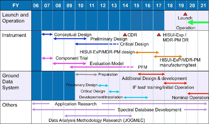
Launch
The HISUI instrument was launched on the SpX CRS-19 (Commercial Resupply-19) Dragon mission to the ISS on 5 December 2019 (17:29:24 UTC). SpaceX launched its CRS-19 mission from Space Launch Complex 40 (SLC-40) at Cape Canaveral Air Force Station, Florida. 6)
Orbit: Near circular orbit, altitude of ~400 km, inclination = 51.6º.
HISUI Instrument
The basic specifications of HISUI are summarized in Table 1. The swath of HISUI is narrow due to the optical design constraints and the available two-dimensional detectors. HISUI consists of a reflective telescope and two spectrometers which cover the VNIR (Visible and Near Infrared Region) and the SWIR (Shortwave Infrared Region). Each spectrometer consists of a grating and a two-dimensional detector. SWIR spectrometer has a Stirling cooler for the SWIR detector.
Spatial resolution | 20 m (cross-track) x 30 m(along-track) |
Swath | 20 km (at an altitude of 400 km) |
Spectral coverage | 0.4 - 2.5 µm |
Spectral resolution | 10 nm (VNIR), 12.5 nm (SWIR) |
Number of bands | 185 |
SNR (Signal-to-Noise Ratio) | >450 @ 620 nm, >300 @ 2100 nm |
MTF (Modulation Transfer Function) | >0.2 |
Dynamic range | 12 bit |
Data compression | Lossless (70%) |
Data rate (70 % compression) | 0.4 Gbit/s |
Maximum data amount per day | 690 GB/day |
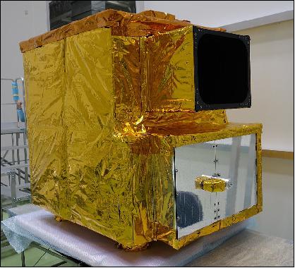
Manufacturing and tests of Flight Model of HISUI (Figure 2) have been almost completed. The HISUI instrument will be deployed on the ISS/JEM/EF (Japanese Experiment Module/Exposed Facility) EPS (Exposed Payload System). Figure 3 includes the structure, the thermal control system, and the electrical system.
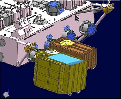
The design of the Payload System, which should meet the interface conditions of ISS/JEM as well as the mission requirement of HISUI, is ongoing. After the instrument is installed into Payload System, an integrated system test will be conducted by 2018.
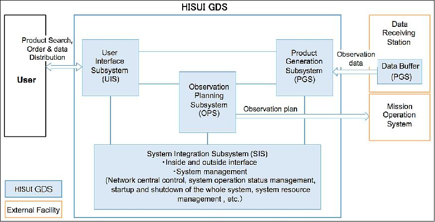
HISUI GDS (Ground Data System)
The development of original HISUI GDS for a dedicated satellite will be finished in FY2017. And additional GDS development, related with HISUI's deployment on the ISS, was started in FY2015.
As shown in Figure 5, the original HISUI GDS consists of four subsystems: OPS (Observation and Planning Subsystem), GPS (Product Generation Subsystem), UIS (User Interface Subsystem), and SIS (System Integration Subsystem).
The project is studying the additional functions to the original GDS to operate HISUI on the ISS. Currently, four functions will be added to current GDS. The first is the generation of command and its management, the second is the telemetry and command database, the third is the distribution of telemetry to the GDS, and the fourth is the monitoring of telemetry and its archive.
The project will also develop the interface between JAXA SSIPC (Space Station Integration and Promotion Center) and the HISUI GDS. The development of HISUI GDS for ISS will be completed in the late FY2018.
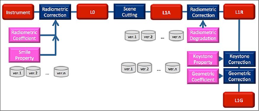
Level 1 Processing
HISUI Level 1 data is a standard product and acts as inputs to higher level products (Table 2). The Level 1 processing flow for HISUI is shown in Figure 6. Level 1 data processing guarantees geometric, radiometric and spectroscopic performances. Radiometric and smile corrections are carried out on orbit. Keystone properties are corrected in the map projection process. Radiometrically corrected Level 1R data are map-projected to orthorectified data, Level 1G. Two slits between VNIR and SWIR spectrometers cause disparity due to the difference in line-of-sight vectors between detectors. To fusion the VNIR and SWIR hyperspectral cubes, a parallax correction is carried out using registration techniques with the aid of the digital elevation models. Since the telescope cannot keep the yaw steering condition on the ISS, a software revision to find the corresponding points is underway.
Product name | Description |
Level 0 | Raw data |
Level 1A / TIFF | Raw DN product with all radiometric calibration coefficients. Spatial resampling is not applied. |
Level 1R / TIFF | Top-of-atmosphere spectral radiance product. Spatial resampling is not applied |
Level 1G/GeoTIFF | Geometrically corrected / orthorectified top-of-atmosphere spectral radiance product. Parallax correction, and keystone property are considered. Spectral continuity between VNIR and SWIR are considered. |
Level 2 (TBD) | Atmospherically corrected surface spectral reflectance product generated from L1G with QA information. This is a Science Product for research purposes and not validated. |
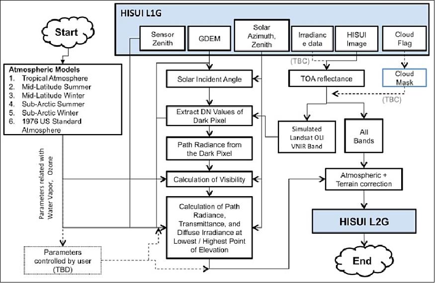
Level 2 Processing
It is necessary to provide surface spectral reflectance information for scientific researches using spectral properties of the targets. The HISUI Level 2 surface reflectance product contains atmospherically corrected surface reflectance for each of the VNIR and SWIR bands. The Level 2 products will be generated from the L1G product, which is an orthorectified TOA (Top-Of-Atmosphere) spectral radiance product with QA information as Science products (Table 2). The HISUI atmospheric correction algorithm will use the "Dark Pixel" method. The project evaluates this algorithm using EO-1 Hyperion data and so on. Currently, the Thuillier (SUN01thkur) and NewKurucz (SUN01kurucz2005) model in MODTRAN5.2 are adopted as the HISUI irradiance model. The validation plans for HISUI atmospheric correction algorithm are to be discussed.
Radiometric Calibration
The pre-launch calibration of HISUI is conducted using a large integrating sphere traceable to the SI, and after the launch, the onboard calibration will be carried out using the onboard calibration unit including a lamp. The vicarious calibration will be conducted over the dry lake sites, located both in the northern and southern hemispheres, and the project may use automated calibration facilities due to orbital characteristics of the ISS.
HISUI will also be cross-calibrated with forthcoming hyperspectral instruments on the ISS. The data associated with these calibrations will be archived in the CDAS (Calibration Data Archive System) and the HISUI Calibration Working Group plans to assess the HISUI radiometric performance and will produce radiometric (geometric) calibration databases over CDAS, which are required in Level 1 processing. 7)
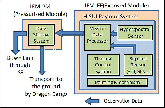
HISUI Mission Planning
HISUI will have its own data receiving, storing, and sending devices on EPS and the JEM PM (Pressurized Module). The HISUI data sent from EPS will be recorded on the removable media in the PM device and after recording, the media will be shipped from the ISS to the Earth several times in a year. In addition, the limited amount of HISUI data will be transmitted from ISS to the ground station in near-real time.
To investigate the requirements on these devices, preliminary long-term operation simulations of HISUI for three years were conducted (Figures 8 and 9). Three types of data acquisition requests were considered in the simulation:
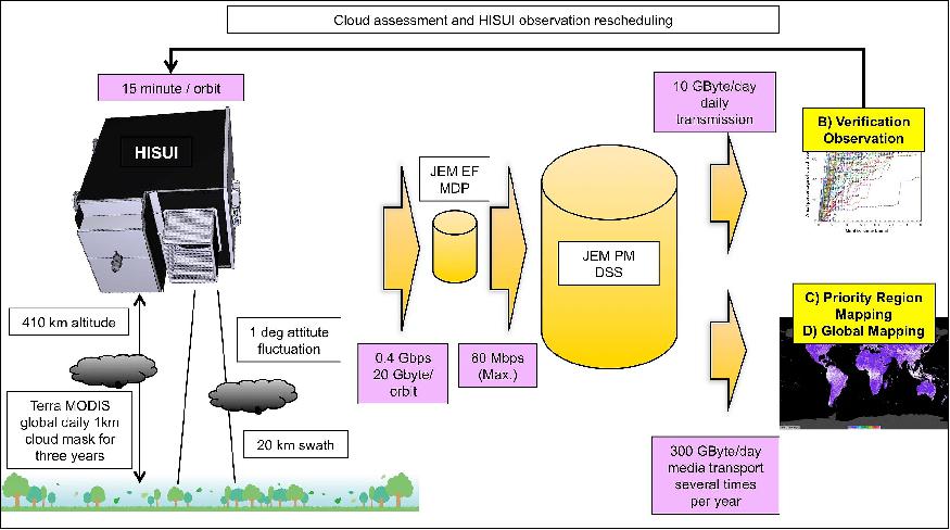
A Globally distributed 200 targets as large as 100 x 100 km.
B Promising areas for oil/gas/metal resources exploration. About 25% of global land and shallow sea regions.
C Global mapping areas which are not covered by items A or B.
It was assumed that data for A are transmitted and data for B and C are shipped via media. The results suggested that within three years, A requests will be completed about 70% (Figure NO TAG#) and B and C requests will be completed more than 90 and 80%, respectively.
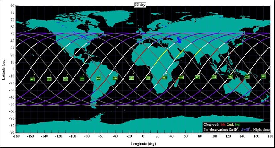
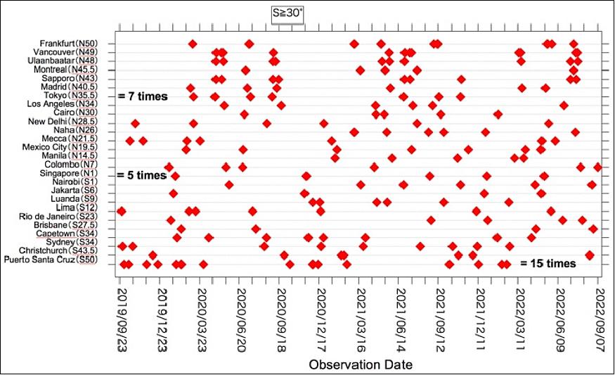
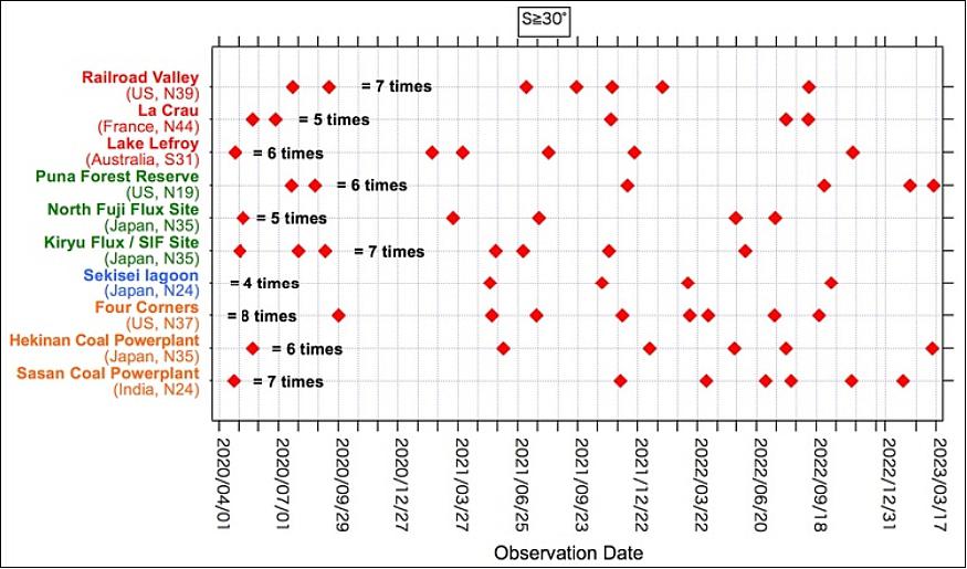
Figure 10 shows HISUI observation opportunities of large cities in three years. The opportunities of cities close to 50°Nor 50°S will be 10 -15 times in three years. However, it will be 5 -7 times for tropical and mid-latitude cities. Figure 11 shows opportunities for calibration and other important sites. HISUI observations for these sites will be about 5 times in three years.
HISUI Data Policy
The HISUI data policy is under consideration and the directions of discussing is as below. For collaborators and research announcement investigators, HISUI project will give priority observation, priority downlink and distribution for their requested areas for free. And for other science users, the HISUI project will distribute the archive data for free when reporting their outcome to the HISUI project.
Synergy with other advanced Earth observation instruments onboard the ISS
Around 2020, there will be several advanced Earth observation instruments on the ISS other than HISUI: DESIS (DLR Earth Sensing Imaging Spectrometer), ECOSTRESS (ECOsystem Spaceborne Thermal Radiometer Experiment on Space Station), OCO-3 (Orbital Carbon Observatory-3), , and GEDI (Global Ecosystem Dynamics Investigation). These instruments will directly measure the concentrations of carbon dioxide, surface temperature, and the height of vegetation.
The synergy among optical, thermal and LiDAR instruments may overcome the limitations of individual instrument although particular research efforts are needed to explore synergies among different data sources. For example, biomass burning represents a significant emission source of carbon and other trace gasses (e.g., methane). However, it is difficult to evaluate the effect of biomass burning by using only one instrument. On the other hand, the severity of biomass burning can be quantified more easily by data of the burned area and volume, fire intensity, and carbon emission estimated from the four instruments onboard the ISS. The synergy among multiple instruments with different characteristics would allow the multifaceted interpretation for complex events.
References
1) Tsuneo Matsunaga, Akira Iwasaki, Satoshi Tsuchida, Koki Iwao, Jun Tanii, Osamu Kashimura, Ryosuke Nakamura, Hirokazu Yamamoto, Soushi Kato, KentaObata, Koichiro Mouri, and Tetsushi Tachikawa, ”Hisui status toward 2010 launch,” Proceedings of the 39th annual IGARSS (International Geoscience and Remote Sensing Symposium) 2019, Yokohama, Japan, 28 July - 2August 2019
2) Tsuneo Matsunaga, Akira Iwasaki, Satoshi Tsuchida, Koki Iwao, Jun Tanii, Osamu Kashimura, Ryosuke Nakamura, Hirokazu Yamamoto, Soushi Kato, Kenta Obata, Koichiro Mouri, Tetsushi Tachikawa, ”Current status of Hyperspectral Imager Suite (HISUI) onboard the International Space Station (ISS),” Proceedings of IGARSS 2017 (IEEE International Geoscience and Remote Sensing Symposium), Fort Worth, Texas, USA, July 23–28, 2017, DOI: 10.1109/IGARSS.2017.8126989
3) Tsuneo Matsunaga, Akira Iwasaki, Satoshi Tsuchida, Koki Iwao, Jun Tanii, Osama Kashimura, Ryosuke Nakamura, Hirokazu Yamamoto, Soushi Kato, Koichiro Mouri, Tetsushi Tachikawa, ”Current status of Hyperspectral Imager Suite (HISUI) and its deployment plan on International Space Station,” Proceedings of IGARSS (International Geoscience and Remote Sensing Symposium), Beijing, China, 10-15 July 2016
4) Tetsushi Tachikawa, Osamu Kashimura, Jun Tanii, Akira Iwasaki, Tsuneo Matsunaga, Satoshi Tsuchida, Hirokazu Yamamoto, ”Outline and Prospect of Hyperspectral Imager Suite (HISUI),” Journal of The Remote Sensing Society of Japan, Vol. 32 (2012) No. 5, pp: 280-286
5) Tsuneo Matsunaga, Akira Iwasaki, Satoshi Tsuchida, Koki Iwao, Jun Tanii, Osamu Kashimura, Ryosuke Nakamura, Hirokazu Yamamoto, Soushi Kato, Kenta Obata, Koichiro Mouri, Tetsushi Tachikawa, ”HISUI status toward FY2019 launch,” Proceedings of IGARSS (International Geoscience and Remote Sensing Symposium), Valencia, Spain, July 23-27, 2018
6) ”SpaceX Dragon Heads to Space Station With NASA Science,” NASA News, 5 December 2019, URL: https://www.jpl.nasa.gov/news/news.php?release=2019-239
7) K. Obata, S. Tsuchida, I. Nagatani, H. Yamamoto, T. Kouyama, Y. Yamada, Y. Yamaguchi, J. Ishii, "An Overview of ISS HISUI Hyperspectral Imager Radiometric Calibration", Proceedings of IGARSS (International Geoscience and Remote Sensing Symposium), Beijing, China, 10-15 July 2016, IEEE International. IEEE, 201, DOI: 10.1109/IGARSS.2016.7729495
The information compiled and edited in this article was provided by Herbert J. Kramer from his documentation of: ”Observation of the Earth and Its Environment: Survey of Missions and Sensors” (Springer Verlag) as well as many other sources after the publication of the 4th edition in 2002. - Comments and corrections to this article are always welcome for further updates (eoportal@symbios.space).