Iris - SESAR
Initiatives and Programs
Iris Precursor - SESAR (Single European Sky Air Traffic Management Research) Program
The ARTES Satellite Communication for Air Traffic Management element, or Iris, aims to supply a validated satellite-based communication solution for the European Air Traffic Management System. It is implemented in close collaboration with the SESAR (Single European Sky Air Traffic Management Research) Program launched in 2006 by EUROCONTROL and the European Community. 1)
Background 2)
Over the first decade of the 21st century, the aviation sector has seen tremendous growth, making Europe the densest air traffic space in the world. As a result, we often experience delays and cancellations due to the saturated air traffic around main hubs such as Frankfurt, Paris and London.
To address this issue, the EC (European Commission) launched the SESAR (Single European Sky Air Traffic Management Research) Program. It supports the implementation of the Single European Sky by looking at all aspects of Air Traffic Management. It also intends to modernize communication infrastructure and increase safety for air traffic participants.
Today, the majority of information still passes through a voice communication channel between the pilot and a controller. This procedure makes it increasingly difficult to introduce automation and to accommodate growth in air traffic.
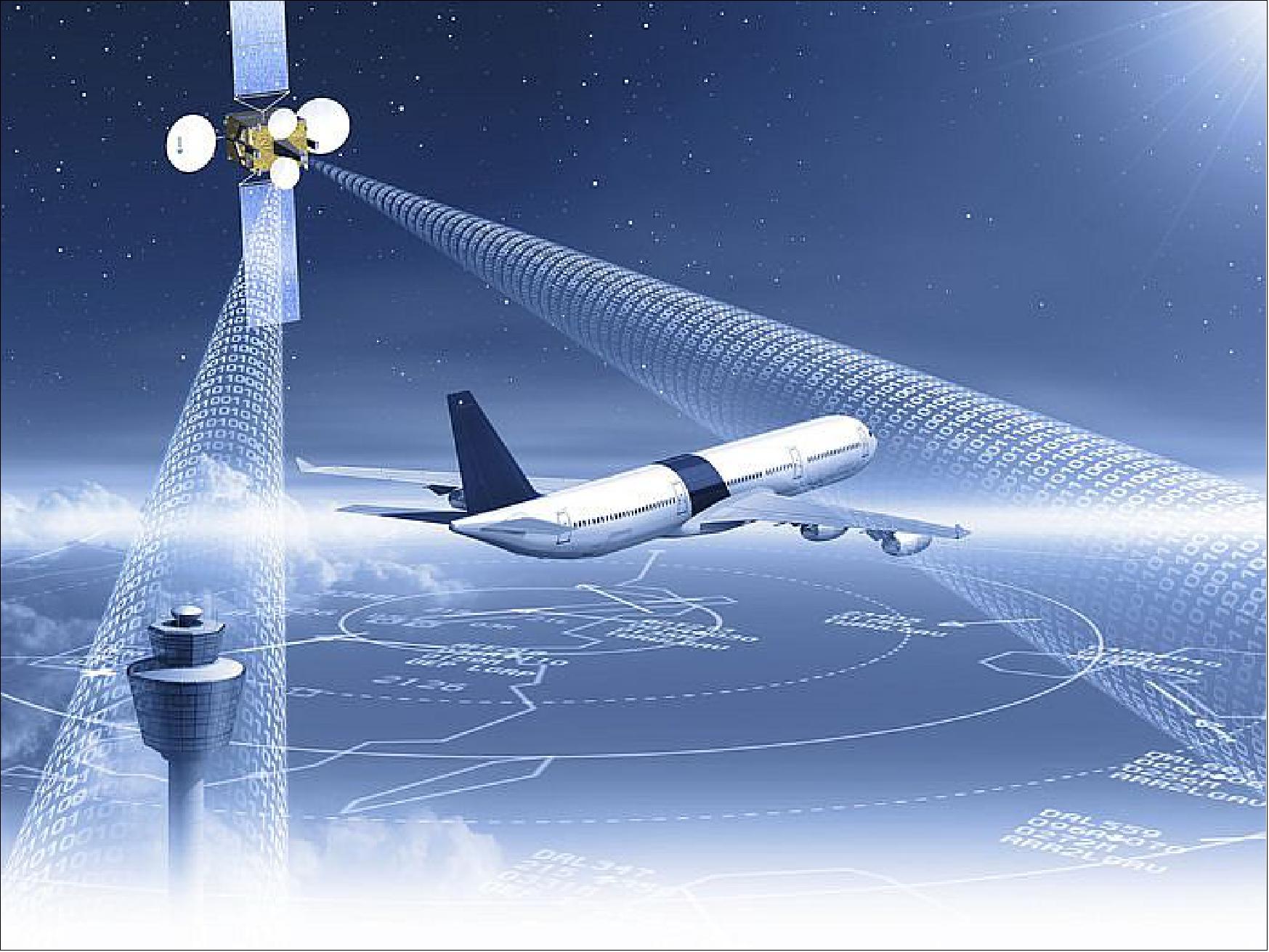
In the future, voice communication between pilots and controllers will become a backup, while data links become standard practice. This will enable the aircraft and the ground to communicate more effectively, increasing the efficiency of common aviation procedures.
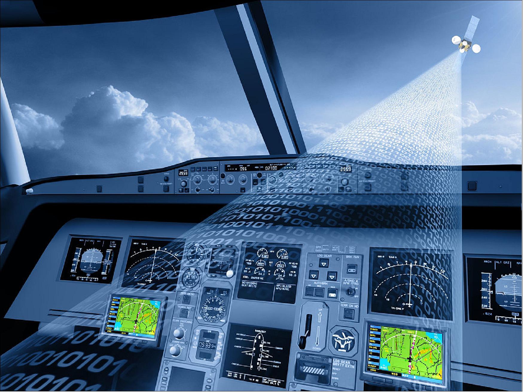
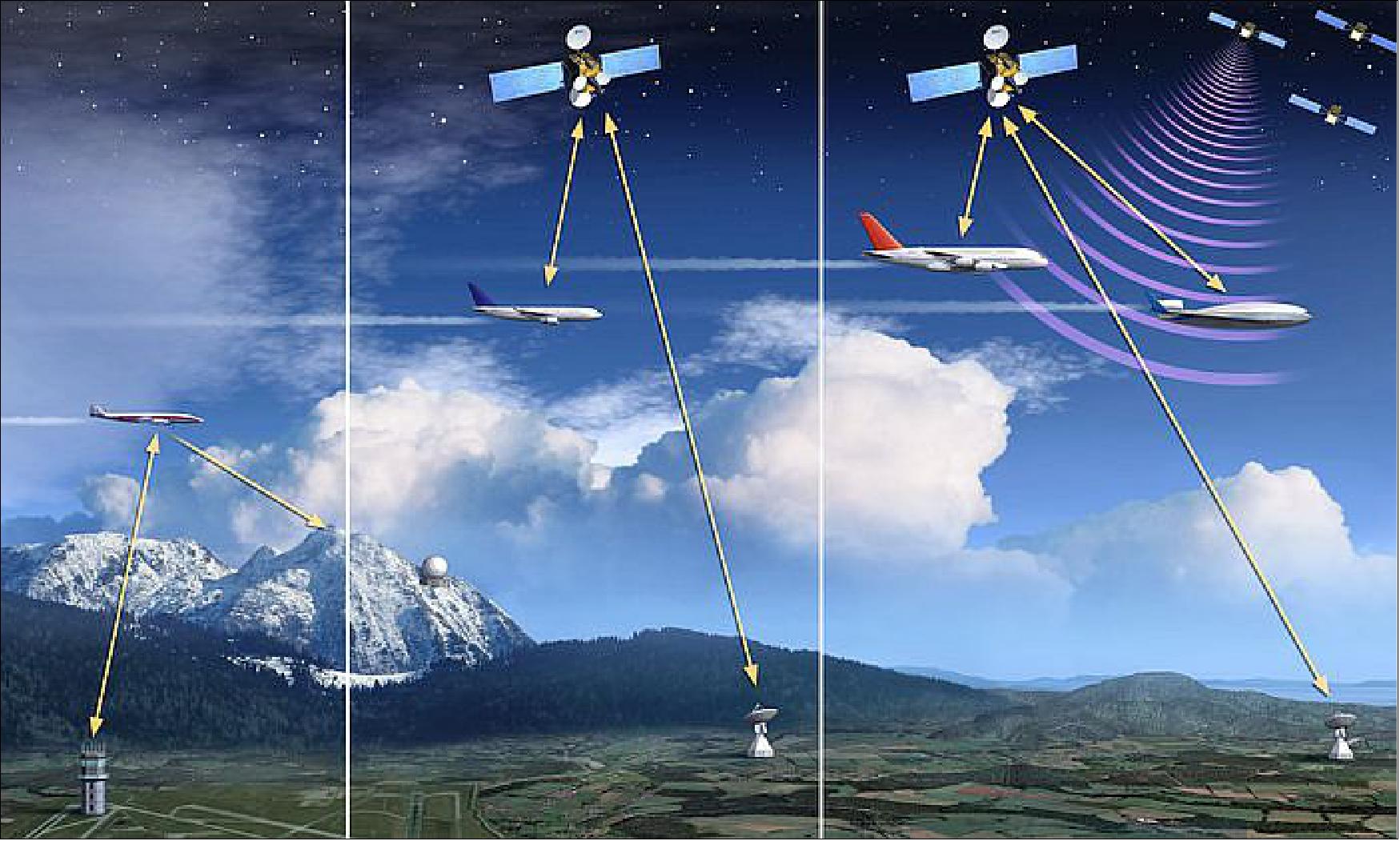
This datalink will become critical to maintaining efficient operations. The service therefore needs to be constantly available and the technology needs to be resilient. It’s a safety system that is fundamental for the future of Air Traffic Management.
SESAR is currently defining and evaluating two different communication technologies that will be used in parallel for this system. A new terrestrial data link, with antennas on-ground, and a satelliteborne solution. This dual-link will offer the safety and capacity requirements for tomorrows Air Traffic Management systems.
ESA (European Space Agency) launched the Iris program in 2007 to develop and validate this new satellite solution. The Iris program is carried out in collaboration with the SESAR Joint Undertaking under the umbrella of ESA’s cooperation with the European Union. The system is being developed by European industry under ESA contract.
The implementation of this communication system implies two parallel developments:
1) The development of technical specifications for a new satellite communication standard. This standard will have to be adopted at the worldwide level, because airlines are truly global in operation.
2) A European satellite infrastructure, which will enable the provision of this service in Europe.
The global standard will ensure that aircraft equipped with a standard terminal will be able to communicate anywhere via compatible satellite systems. In practice, the flight crew will send and receive information to and from flight management facilities across Europe. Using this system will be transparent to the pilot and the controller. This information will be relayed via satellites placed in geo stationary orbit. The system will be designed to ensure low costs both for equipping the aircraft and for the ongoing service of handling communications.
The Iris Precursor Program is a new type of initiative for ESA: one where the space component is a tool in a much bigger system. The Iris program is tuned to the needs of external partners and end users not always familiar with satellite technology. The total Development Phase for Iris will run until 2015, followed by the deployment of a fully operational system in 2020.
This investment into the future will contribute in making air travel in Europe safer, more efficient, environmentally sound and cost effective.
Overview of Iris Development within ESA's ARTES 10 Program
Iris, element 10 of the ARTES program, aims to supply a validated satellite-based communication solution for the European ATM (Air Traffic Management System). It is implemented in close collaboration with the SESAR (Single European Sky Air Traffic Management Research) Program launched in 2006 by Eurocontrol and the European Community. ARTES 10 is the ESA program to support the development of a satellite-based communication system for the European ATM. 3)
The Iris Program is a new type of initiative for ESA, where the space component is one of the component in a much larger system, tuned to the needs of external partners and end-users who are not always familiar with satellite technology. Because of this, a long-term, incremental approach is necessary.
Iris will complement existing and planned systems, supporting the growth of worldwide air traffic. It is anticipated that Iris will be fully operational in 2028, with deployment of a precursor service foreseen for 2018.
Iris will enable 4D trajectory management via satellite, for both continental and oceanic airspaces, as a safe and reliable service. Communications will take place via robust data links and will ultimately be used by the vast majority of aircraft, complemented with conventional voice communications between pilots and controllers. To achieve this goal, Iris will also develop and validate a new standard for satellite communications that can be used for ATM in any region of the world.
Iris is part of a much broader push to modernize how air traffic is managed in close collaboration with the SESAR Joint Undertaking launched in 2006 by EUROCONTROL and the European Union. The new communication system will be standardized by EUROCAE (European Organization for Civil Aviation Equipment) and the ICAO (International Civil Aviation Organization).
The objective of the SESAR program is to develop a high-performance ATM system to enable the safe and environmentally-friendly development of air transport. The SESAR program is defining and evaluating two different communication technologies that will be used in parallel for this system. A new terrestrial data link, with antennas on-ground, and a satellite-based service. This multi-link will offer the safety and capacity requirements for tomorrow's ATM systems.
ESA's objective is to help aviation authorities to deploy a global service supplied by multiple parties. ESA activities belong to the satellite technology domain; the SESAR Joint Undertaking will then use this technology for the operational service verification, before the final deployment.
Development Status
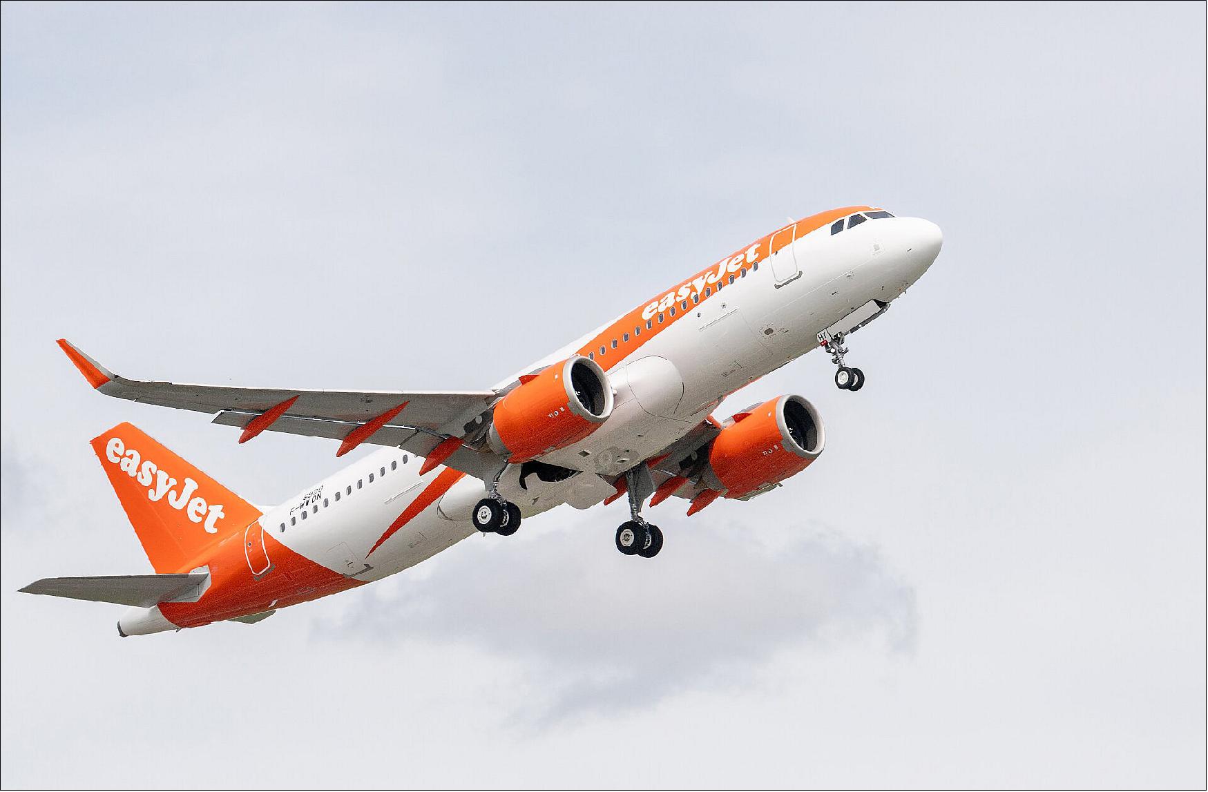
• June 21, 2022: Passengers on board commercial airline easyJet will speed to their destinations faster and greener, thanks to an ESA-backed initiative to digitalise the skies. 4)
- The Iris system uses satellites to connect pilots digitally to air traffic controllers, so that flight routes can be optimised. Pilots will be able to fly the most efficient routes, saving time and fuel while cutting emissions of planet-warming carbon dioxide (CO2).
- easyJet will fit the Iris system to up to 11 newly delivered Airbus A320neo aircraft, flying commercially from November 2022.
- ESA developed the Iris system in partnership with UK-based satellite communication company Inmarsat to help ease congestion in the skies. Air travel is increasing rapidly and is expected to return to pre-pandemic levels within the next few years and to continue to rise thereafter.
- At present pilots mostly communicate with air traffic controllers by voice or by using an outdated data communication technology. This makes flight operations inefficient, as planes have to be kept further apart from one another and follow pre-defined air corridors instead of taking the most direct route.
- Data exchanges will soon become the primary means of communication, with large quantities of data relayed to and from the aircraft. Iris provides highly secure, high-bandwidth links between pilots and air traffic controllers.
- Philippe Carette, President of Inmarsat Aviation, said: “Having easyJet onboard as our first Iris partner is excellent news, not least because of its pioneering commitment to innovation and reducing the aviation industry’s environmental impact. With Iris we are kickstarting a new era that will help make aviation greener, and the more airlines that step forward to evaluate Iris’ capabilities, the sooner this will become reality.”
- Hugh McConnellogue, Director of Airport Operations and Navigation at easyJet, said: “Iris is paving the way for more efficient air traffic management, which is a crucial step forward for the aviation industry. The Iris programme brings multiple benefits, from helping us to achieve our environmental goals by further reducing our carbon emissions from flying, to providing a better experience for our passengers. We are excited to be leading in this space, setting the standard for the aviation industry and hope to see more airlines follow suit.”
- Elodie Viau, Director of Telecommunications and Integrated Applications at ESA, said: “This innovation has been an enormous undertaking by ESA, Inmarsat and more than 30 other companies within the space and aviation industry, so to see it finally ‘take to the skies’ in a live operational environment is very exciting. European airspace is crying out for a solution to its capacity issues, and advanced satellite technology is the only way to set the industry up for a better – and greener – future.”
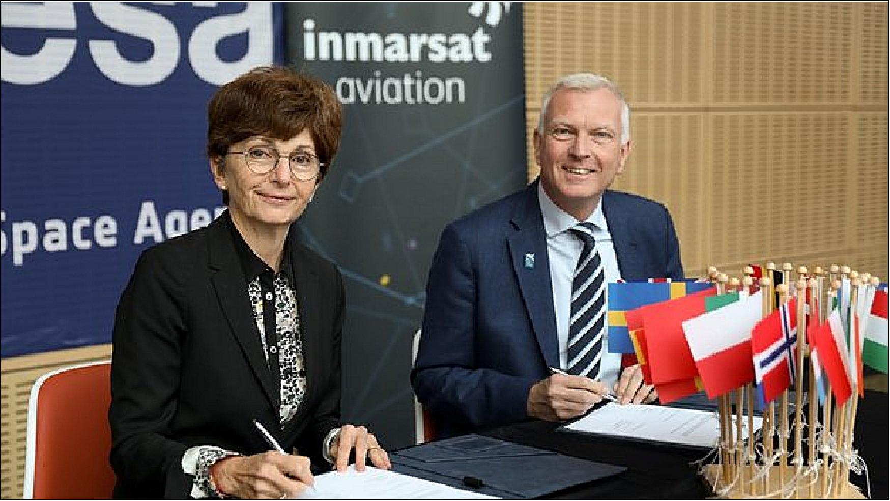
• June 9, 2022: A space-enabled system to help clear congested skies while reducing carbon emissions is going global, following a deal signed today between satellite communications provider Inmarsat and ESA. 5)
- Passengers will experience fewer delays once the Iris system is fully implemented – and airlines will save fuel and reduce emissions of carbon dioxide. It could even be used to safely coordinate the flights of drones delivering medical supplies between hospitals or aid to remote communities.
- Air travel is increasing and is expected to return to pre-pandemic levels within the next few years. It is predicted to continue to rise thereafter, which will further increase congestion in the skies, while airlines find ways to become more carbon neutral.
- At present pilots mostly communicate with air traffic controllers by voice or by using an outdated data communication technology. This makes flight operations inefficient, as planes have to be kept far apart from one another and follow pre-defined air corridors instead of taking the most direct route.
- Data exchanges will soon become the primary means of communication, with large quantities of data relayed to and from the aircraft.
- The Iris system uses satellites to relay data digitally from the cockpit to the ground, increasing communication capacity and coverage including remote and oceanic areas. This means that flight plans can be continually updated during the flight to maintain an optimal trajectory towards the destination, minimising the fuel burned and the carbon dioxide emitted.
- Iris has been fully validated within Europe and is due to become operational on commercial flights across Europe at the start of 2023. Today’s agreement means that it is now ready to be assessed and adapted for use in other regions such as Asia and the Americas.
- Rajeev Suri, Chief Executive of Inmarsat, said: “Capacity crunches are a major issue worldwide – and relying on existing technologies alone won’t solve the problem. Iris will have an enormous impact in Europe as it enters service in 2023, which is set to continue at pace as air travel increases and the push for more sustainable aviation operations grows.
- “It’s a natural next step for us to expand its remit beyond European airspace and share our spoils with the rest of the world. To beat capacity issues and make aviation greener long-term, as well as successfully integrate unmanned aerial vehicles into our airspace as soon as possible, we need the right technologies on board every aircraft – and this starts with Iris.”
- Paul Bate, Chief Executive of the UK Space Agency, said: “Iris is a real-world example of how space and satellite technologies can bring huge benefits to global industries, making operations more efficient while cutting carbon emissions. There is great potential to catalyse more investment into the space industry by showcasing these benefits, and I’m delighted that Iris was developed in the UK by Inmarsat, thanks to the UK Space Agency's investment in commercially focused ESA programmes.”
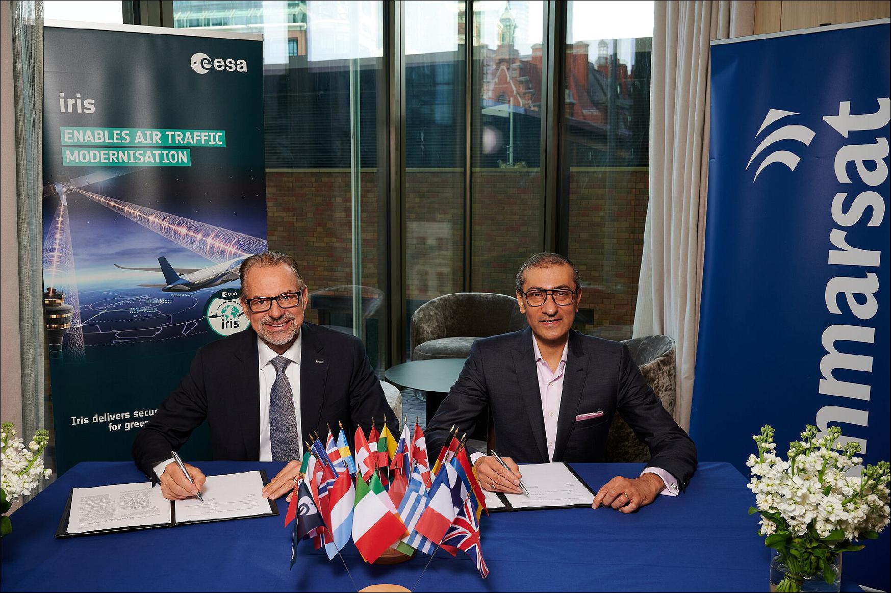
- Josef Aschbacher, ESA Director General, said: “Iris is a major step forward towards creating a more sustainable and efficient aviation industry. It is exciting to see the progress we have made so far – but this is only just the beginning.
- “Iris Global will extend the benefits of innovation and operational efficiency beyond Europe to other parts of the world. Reaching carbon neutrality for air traffic management by 2050 will be challenging, but we are hope to contribute through innovation in space to achieve this ambitious goal.”
- Iris is backed by a consortium of 16 European partners, including the European Satellite Services Provider (ESSP), which is leading the certification effort. The ESSP was founded by seven national air traffic control organisations from France, Germany, Italy, Portugal, Spain, Switzerland and the UK.
- Charlotte Neyret, Chief Executive Officer of the ESSP, said: “The Iris programme is a game-changer for the aviation industry, providing the most advanced new technology to complement datalink communications and meet the challenge of digital, greener and more sustainable air travel. As a stepping stone for the future datalink service provider organisation under discussion, ESSP is proud to lend its expertise on this important programme that will deliver a pan-European certified service for the first time.”
• October 27, 2021: Air passengers will soon be able to cut their carbon footprint when travelling on flights that are routed using satellites. 6)
- An agreement signed today between satellite company Inmarsat and the European Satellite Services Provider, which represents air traffic controllers from seven European countries, will enable final tests of the space-based system to be conducted and evaluated. It is expected to be introduced across Europe by 2023.
- ESA has worked with Inmarsat to develop a space-enabled digital alternative to traditional air traffic control that enables pilots to take more efficient trajectories, saving fuel and cutting carbon emissions.
- The system – called Iris – uses satellites to exchange data with aircraft, supplementing the terrestrial communications system with digital position reports, clearances and runway conditions, sent via telecommunications satellites between cockpits and air traffic control centers.
- Flight plans can be continually updated during the flight to maintain an optimal trajectory towards the destination, minimizing the fuel burned and the carbon dioxide emitted.
- Iris was first tested on planes flying over Europe in 2018 and debuted in the US on a new Boeing 737-9 operated by Alaska Airlines earlier this year.
- Today’s agreement is between Inmarsat and the European Satellite Services Provider (ESSP), a company founded by seven air navigation service providers from France, Germany, Italy, Portugal, Spain, Switzerland and the UK to operate and provide services for a satellite-based navigation system managed by the European Commission called the European Geostationary Navigation Overlay Service.
- It aims to manage final testing and certification – which includes certification from the European Aviation Safety Agency ahead of commercial rollout across Europe. The agreement was signed today at the World Air Traffic Management Congress in Madrid.
- Iris will implement its improvements under the European Commission’s single European sky air traffic management research program, which promises to boost efficiency, capacity and performance of air traffic management worldwide.
- John Broughton, Senior Vice President of Aircraft Operations and Safety Services at Inmarsat, said: “There is monumental support within the aviation industry for modernizing air traffic management. The benefits for airlines and passengers are vast, from faster and more efficient flight routes with less delays, to improvements in environment efficiencies, including less fuel usage and carbon dioxide emissions.”
- Charlotte Neyret, Chief Executive Officer of the European Satellite Services Provider, said: “The Iris program is a game-changer for the aviation industry, providing the most advanced new technology to complement datalink communications and meet the challenge of digital, greener and sustainable air travel. The ESSP has been working on this important program with Inmarsat and ESA for several years and we are proud to now expand our involvement. We will provide the full range of ESSP's expertise in implementing and operating mission-critical services to ensure that Iris will offer the highest quality of service to all aviation stakeholders."
- Elodie Viau, Director of Telecommunications and Integrated Applications at ESA, said: “ESA is proud to work with Inmarsat and the European Satellite Services Provider to digitalize air space and reduce the environmental impact of flying, while simultaneously improving the efficiency of the aviation industry. The digitalization of our skies will lead to a greener environment, a better passenger experience, and a more competitive European economy.”
• June 19, 2020: Commercial flight trials that use satellite-enabled communications to reduce the environmental impact of flying are scheduled to commence once normal traffic levels resume. 7)
- As nations begin to recover from the coronavirus pandemic and airports start to reopen in Europe, satellite communications provider Inmarsat and the consultancy firm CGI (Client Global Insights) will be conducting real-world trials of the Iris air traffic modernization program developed with ESA.
- Some 20 aircraft flying commercially will be equipped with the technology.
- Fitting aircraft with Iris satellite data communication technology enables air traffic controllers to manage the skies more efficiently through data communications, which are delivered through a high bandwidth, cost effective satellite datalink between the aircraft and air traffic management.
- Flight plans can be continually updated during the flight to maintain an optimal trajectory towards the destination, minimizing the fuel burned and the carbon dioxide emitted. Satellite communications also reduce the pressure on ground-based frequencies.
- The trials will begin as soon as normal traffic levels start to resume.
- Several national air traffic control organizations have already agreed to trial the commercial system, including those of Belgium, France, Germany, Italy, Luxembourg, the Netherlands, Portugal, Spain, Switzerland and the UK.
- Shaun Stretton, Vice President of Satellite Communications and Space Data Platforms at CGI, said: “This is a significant step for the Iris program towards transforming aircraft communications across Europe.”
- Jerome Soumagne, Vice President of Networks at Inmarsat, said: “Flying the Iris technology marks a key milestone for this important program and brings us closer to the realization of modernized air traffic management across Europe. We are pleased to partner with key technology providers to deliver this ground-breaking, secure and reliable data link, which will enable more efficient and environmentally friendly flights.”
- Emily Gravestock, Head of Applications Strategy at the UK Space Agency, said: “Iris is a great example of the potential for satellite applications to bring real benefits to industry and people’s lives, by cutting carbon emissions and modernizing air traffic management. The UK is the leading investor in ESA’s telecommunications and applications program, which supports our growing space sector and world-class companies.”
- Antonio Garutti, Head of Telecommunication Systems Project Office at ESA, said: “Iris is reaching deployment maturity as we approach commercial availability. ESA is very proud to continuously contribute to the evolution of this process and to the digitalization of our skies, which we hope will lead to a greener environment, a better passenger experience, and a more competitive European economy.”
• October 3, 2019: Air travel is set to become safer, swifter and more environmentally friendly thanks to the introduction of space-based technologies. ESA has just signed a deal with Inmarsat, a global satellite communications company, to put satellite-based data communication links terminals on up to 20 aircraft flying commercial services across continental Europe. 8)
- The Iris terminals are designed to help pilots and air traffic controllers to use the shortest and fastest routes, boosting productivity, saving fuel and reducing environmental pollution.
- The VHF radio channels that pilots currently use are already congested. With the number of flights projected to nearly double to 7.2 billion by 2035, these channels are expected to reach capacity limits for voice and data links in less than a decade.
- The Iris system will help to relieve pressure on these terrestrial channels by supplementing them with a much larger pipe for digital information relayed via satellites. The system enables European air traffic managers accelerate the transition from a largely voice-based to digital-based exchanges.
- Satellite communication systems such as Iris are among the essential enablers supporting the next generation air traffic management in Europe, in line with the Single European Sky Air Traffic Management Research (SESAR) program, under the leadership of the European Commission.
- Iris permits flight plans to be continually updated during the flight to maintain an optimal trajectory towards the destination. This allows air traffic controllers to schedule landings well in advance, maximizing airspace and airport capacity, while minimizing the fuel burned and the carbon dioxide emitted.
- Satellites provide safe, secure, reliable and resilient connectivity, thanks to their high capacity and high availability in situations where security and service availability are paramount.
- The Iris data-link connection is protected by advanced firewalls and by the segregation of systems that adhere to the latest software security standards. This protects the integrity of the data by keeping each system functioning independently.
- Satellites have been used to track aircraft over oceans and remote areas for decades. The technology has now been upgraded and is poised for deployment to serve continental airspace, starting with Europe and extending globally.
- To deliver Iris, ESA is working with Inmarsat and a consortium of air navigation service providers, avionics manufacturers and ground segment providers, in full coordination and cooperation with the SESAR program for its validation.
- John Broughton, Vice President, Operational and Safety Services at Inmarsat Aviation, said: “We are very excited to embark on the next phase of Iris with all of our partners. Important progress has already been made on various critical elements and, as a result of strong industry-wide interest, several important agreements have been signed with major European air navigation service providers, aircraft manufacturers and airlines. Today’s agreement brings us another step closer to delivering the Iris program.”
- Magali Vaissiere, Director of Telecommunications and Integrated Applications at ESA, said: “Flying this technology for six months on some 20 aircraft brings years of research and preparation closer to fruition. We are a step closer to making real the highly anticipated idea of a modern air traffic management system over Europe. We look forward to seeing the results of the commercial flight demonstrations, and the environmental and operational benefits that Iris will bring to Europe’s congested airspace.”
• March 13, 2019: Passengers travelling through busy airports should soon face fewer delays and have a lower environmental impact, thanks to efforts to use airspace more efficiently. 9)
- The Iris program seeks to equip aircraft with satellite-based data communication links to help pilots and air traffic controllers to use the shortest and fastest routes, boosting productivity, saving fuel and reducing environmental pollution.
- Funded by the European Space Agency in collaboration with Inmarsat, a global satellite communications company based in London, the system will be piloted on selected flights over the coming months and is scheduled to begin commercial service in 2021.
- Several national air traffic control organizations have agreed to trial the commercial system, including those of Belgium, France, Germany, Italy, Luxembourg, the Netherlands, Portugal, Spain, Switzerland and the UK.
- Aircraft manufacturers are now developing and certifying commercial avionics to support the technology, and Inmarsat has entered into an agreement with the European Satellite Services Provider (a group of seven national air traffic management organizations) to identify future markets and business opportunities for the service.
- Magali Vaissiere, Director of Telecommunications and Integrated Applications at ESA, said: “The Iris technology is ready for implementation. We are extremely pleased to have passed this very significant milestone on the road to safer, greener and more efficient air travel.”
- The space-based technology will complement the existing terrestrial system. At present, air traffic controllers use radar to detect the location of aircraft and their direction of travel. They then speak to the pilots, advising them on their route. However, this approach is labor intensive and requires large safety buffer zones around planes, which can restrict air traffic capacity and lead to delays. Moreover, it requires line-of-sight between the planes and the land-based radar stations, which is impossible when aircraft are flying over oceans, leading to the use of even bigger buffer zones.
- Inmarsat has been working with ESA to develop a way to digitize the system. Fitting each aircraft with Iris satellite data communication terminals enables air traffic controllers to manage the world’s increasingly crowded skies without having to speak to each pilot individually. Flight plans can be continually updated during the flight to maintain an optimal trajectory towards the destination. This allows air traffic controllers to schedule landings well in advance, maximizing airspace and airport capacity, while minimizing the fuel burned and the carbon dioxide emitted.
- The Iris system demonstrates how ESA can support a European industrial consortium to deliver innovative solutions of global importance. Together they have developed Iris into an enabling tool for the aviation sector and for ESA’s European Commission partners in the SESAR (Single European Sky Air-Traffic-Management Research) modernization program.
- Peter Hotham, Deputy Director of the SESAR Joint Undertaking, said: “Satellite communications is an important enabler for the digital transformation of Europe’s aviation and air navigation system. With our ongoing cooperation with ESA, we have the means to align towards an integrated roadmap for satellite communications under the overarching Air Traffic Management architecture further elaborated in the European Air Traffic Management Master Plan.”
- John Broughton, Vice President of Operational and Safety Services at Inmarsat Aviation, said: “The progress of the Iris program to date has been phenomenal. With the system design and flight tests now complete, industry-wide interest and commitment to the program has led to several important agreements with major European air navigation service providers, original equipment manufacturers and a leading commercial European airline. These partnerships have brought us one step closer to commercial service for Iris, and enabling the SESAR objective of modernizing air traffic management across Europe.”
• November 21, 2018: Inmarsat has signed agreements with five major Air Navigation Services Providers (ANSPs) in support of the ESA-Inmarsat Iris program to modernize air traffic management (ATM) across Europe. 10) 11) 12)
- DFS (Germany), ENAIRE (Spain), ENAV (Italy), EUROCONTROL MUAC (North-West Germany, Belgium, Luxembourg and the Netherlands) and NATS (UK), who together handle the majority of European air traffic, will join an Initial Operational Capability (IOC) pilot, marking a significant milestone for the early implementation phase of Iris.
- Separately, Inmarsat have also signed a contract with European Satellite Services Provider (ESSP), a company owned by European ANSPs and focused on safety of life services, in accordance with International Civil Aviation Organization (ICAO) standards. ESSP will work with the Iris consortium to help define the service and certification framework of the future Iris Service Provider, a company that will be appointed under the program to provide the European datalink communication services for Iris.
ESA Partnership
- ESSP will work with us to help define the service and certification framework of the future Iris Service Provider, a company that will be appointed under the program to provide the European datalink communication services for Iris.
- The Iris program is a partnership with the European Space Agency (ESA) and led by Inmarsat to enable secure, high bandwidth datalink communications over Europe. The objective is to deploy more digital controller-pilot communications to improve the speed and accuracy of air traffic management across Europe’s congested airspace.
- ANSPs will be able to rely on Iris’ certified, efficient and sustainable datalink to increase ATM efficiency, relieve air traffic controller workload and enhance flight safety.

4D Trajectories
- Iris is also designed to enable initial ‘4D’ trajectories, pinpointing an aircraft in four dimensions: latitude, longitude, altitude and time, which is one of the major concepts defined in the Single European Sky ATM Research (SESAR) modernization program.
- This will enable precise tracking of flights and more efficient management of traffic by allowing pilots and controllers to collaborate on flight trajectories and calculate the shortest available routes, cruise at optimum altitudes, and use continuous climb and descent path to reduce delays, save fuel and improve the environment.
- John Broughton, Vice President, Safety and Operational Services at Inmarsat Aviation, said: “As we enter the early implementation phase of Iris, the range of ANSPs that have committed to further its development is testament to the program’s significance to the European and global aviation industry.
Industry-leading ANSPs
- “Iris is a truly collaborative partnership, and we are delighted to bring on board these industry-leading ANSPs to help deliver our shared goal of modernizing air traffic management in Europe.”
- Magali Vaissiere, Director of Telecommunications and Integrated Applications, ESA, said: “The satellite-based Iris system is a key element for a successful implementation in Europe of the Air Traffic Management Data Link Services (DLS) with the outlook to become a global worldwide solution.
- “We are extremely pleased that key European Air Navigation Service Providers have taken the challenge to exploit and strengthen the opportunity that Iris is offering for the benefit of European citizens now and in the coming years of digitalization.”
• July 19, 2018: SESAR Deployment Manager and the European Space Agency (ESA) have today signed a Memorandum of Cooperation (MoC) marking the start of the collaboration between both organizations. The MoC will see both organizations coordinate over the deployment of the satellite-based communication system (Iris) and SESAR Deployment in Europe. 13)
- A special focus of the cooperation will be on the use of satellite and Iris as a complementary datalink air-ground communication technology. Iris is currently undergoing flight trials which are meeting their technical objectives. This demonstrates that ESA is on track for Iris to deliver an initial service in 2020 as a result of the current contract in place.
- Signing the Memorandum of Cooperation sets out the basis for efficient cooperation between SESAR Deployment Manager and ESA as both organizations address their respective responsibilities on the deployment of SESAR and the satellite-based communication system that helps to enable it. This is an important cooperation, addressing key parts of the short, medium,and long-term development of the Single European Sky. As such it will bring profound benefits for European citizens, industry and Member States for decades to come.
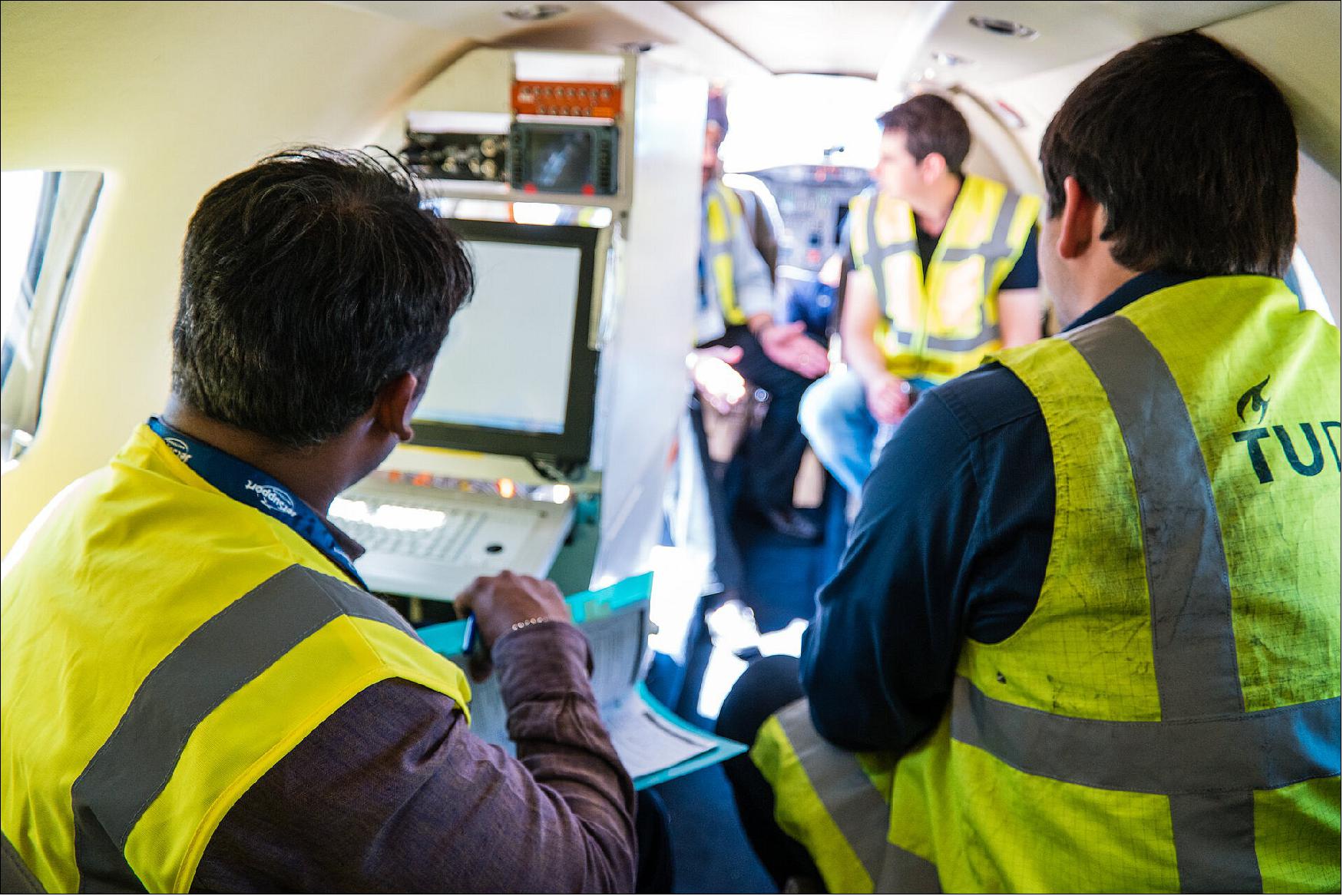
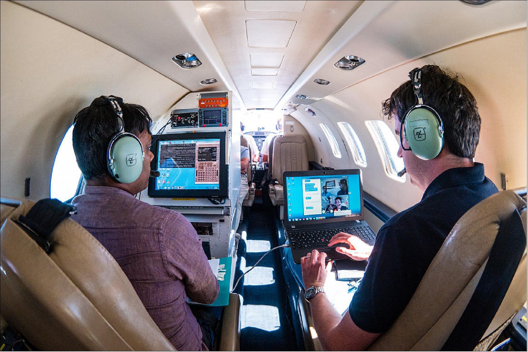
• July 12, 2018: Engineers are shown testing Iris equipment to exchange messages in real-time with a flight control facility from a Cessna plane, which took off from Amsterdam Schiphol airport and flew over the Netherlands and the North Sea for three hours to test the system’s connection. 14) 15)
- Iris will provide a safe and secure text-based data link between pilots and air traffic control (ATC) networks using satellite technology.
- The program is developed under a public-private partnership between ESA and Inmarsat, and will help relieve pressure on the aviation sector's congested radio frequency communication channels.
- It is part of the European Commission’s SESAR (Single European Sky ATM Research) masterplan to modernize Europe's air traffic management.
• January 17, 2018: ESA has signed a €41.3 million contract with Inmarsat to help get more flights in the air with fewer delays, increased safety and reduced carbon dioxide emissions. 16)
- The program will introduce a safe and secure satellite-based air traffic management data link between aircraft and ATC (Air Traffic Control) to relieve the congested radio frequencies used today.
- The contract was signed this month during a ceremony in London. ESA, Inmarsat (GB), Thales Alenia Space (IT), CGI (GB) and an industrial consortium will now start finalizing the technology and preparing the implementation across Europe.
- Iris supports the SESAR (Single European Sky ATM Research) Master Plan for the next-generation of air traffic management. SESAR provides recommendations on how to deliver security, capacity, safety and efficiency benefits for European air traffic. This is crucial, as the number of flights in European skies is expected to grow by 50% over the next 20 years.
- Satellite data links between aircraft and ATC are currently mainly used as support over oceanic airspace. The already-congested European continent still relies on radar- and radio-based ATM systems, which require aircraft to be separated by a certain distance or time to ensure safety. Poor weather conditions can also hamper pilots’ and ATC’s ability to navigate the skies safely, and necessitate even larger gaps between flight paths.
- These limitations have brought Europe’s airspace to near-saturation, resulting in mass flight delays and cancellations and wasting untold amounts of time and money. As our skies become busier, the terrestrial data link systems will reach full capacity by 2025–30, which is why SESAR has recognized the need for a complementary technology solution.
- ESA and Inmarsat have been testing and developing the Iris ground network and cockpit terminals that will help to do just that. Iris technology will relay vital aircraft information and safety services to air traffic control using satellites, creating a secure satcom-based solution that will relieve pressure on existing data link communications. Controller-pilot communications will increasingly move to digital text instead of voice, improving speed and accuracy.
- Iris is also designed to enable initial ‘4D’ trajectories, pinpointing an aircraft in four dimensions: latitude, longitude, altitude and time, which is one of the major concepts defined in SESAR. This will enable precise tracking of flights and more efficient management of traffic through TBO (Trajectory-based Operations). TBO allows pilots and controllers to collaborate on flight trajectories and calculate the shortest available routes, cruise at optimum altitudes, and use continuous climb and descent paths, saving fuel and improving the environment.
- Iris will also define how modernization programs can evolve to enable full 4D trajectory management over airspaces across the globe, with satellite data link becoming a primary means of secure communications between controllers and aircraft.
- Magali Vaissiere, ESA’s Director of Telecommunications and Integrated Applications, said: “It is hard to overstate the impact this new application of satellite technology will have on modern air travel. We have been working on the Iris program with Inmarsat and our other partners since 2012, and are happy to now be able to implement the result of this extensive research and development to improve both the European economy and the lives of European citizens in this very tangible way.”
- Rupert Pearce, Chief Executive Officer of Inmarsat, said: “This is an incredibly important project for us, but more importantly, it is fundamental to the future of European aviation. Europe’s aviation industry is under intense pressure due to limited airspace capacity. The advanced capabilities of Iris will mark a step change, helping to address the limitations of today’s legacy protocols and paving the way for more efficient, cost-effective air traffic management.”
• December 20, 2016: ESA recently completed its first flight trials using satellites to help bring Europe closer to its goal of modernizing air traffic control. The trials are part of the public–private partnership between ESA and UK satellite operator Inmarsat to deliver high-capacity secure digital data links via satellite for air–ground communications for cockpit crews over European airspace under ESA’s Iris Precursor program. 17) 18)
- By 2019, Iris Precursor will provide air–ground communications for initial ‘4D’ flight path control, pinpointing an aircraft in four dimensions: latitude, longitude, altitude and time. This will enable precise tracking of flights and more efficient management of traffic.
- An aircraft from the Netherlands Aerospace Center carried a prototype Iris terminal connected to Inmarsat’s next-generation SB-S (SwiftBroadband-Safety) satellite service as it took off from Amsterdam. During four flights to different destinations in Europe, the connection between the aircraft and ground networks was tested extensively and air traffic control messages were exchanged. The connection was maintained even when the aircraft switched satellite beams.
- “ESA’s Iris program is forging ahead as part of Europe's long-term goal to modernize air traffic control. A stepped approach and good collaboration between public and private partners is bringing excellent results,” commented Magali Vaissiere, Director of Telecommunications and Integrated Applications at ESA.
• On Sept. 15, 2016, ESA and the SESAR Joint Undertaking signed an agreement to foster even closer ties between their technical programs and align key milestones. The SESAR (Single European Sky ATM Research) program promises to boost efficiency, capacity and performance for managing air traffic worldwide. ESA’s Iris program will provide the satcom technology for this. 19)
- By 2018, Iris will provide air–ground communications for initial ‘4D’ flight path control, pinpointing an aircraft in four dimensions: latitude, longitude, altitude and time. This will enable precise tracking of flights and more efficient management of traffic. High-capacity digital data links via satellite carrying this information to cockpit crews in continental and oceanic airspace are expected to become the norm, with voice communications used only for specific operations.
• March 9, 2016: Together with the Netherlands Aerospace Centre (Nationaal Lucht- en Ruimtevaartlaboratorium; NLR), the German Aerospace Center (Deutsches Zentrum für Luft- und Raumfahrt; DLR) has become a member of the EU Single European Sky ATM (Air Traffic Management) research program, known as SESAR 2020. 20)
• March 8, 2016: ESA and UK satellite operator Inmarsat are forging ahead with the development of air–ground communications via satellite as part of Europe’s plan to keep our skies safe as air traffic increases. A new partnership between ESA and Inmarsat secures the modernization of ATM (Air Traffic Management) and will build on developments already under way in Europe. 21)
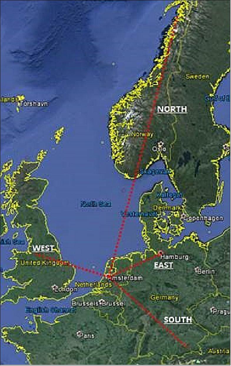
- On Feb 23, 2016, the Iris Precursor operated a first test flight between Toulouse and the Balearic Islands passing above Madrid, performing initial 4D flight path control and controller–pilot data link exchanges with the Maastricht Upper Area Control Center.
- By 2018, in an essential milestone for Iris, the Precursor service will provide air–ground communications for initial 4D flight path control, pinpointing an aircraft in four dimensions: latitude, longitude, altitude and time. This will enable precise tracking of flights and more efficient management of traffic so that flight plans can be continually updated during flight to maintain an optimal trajectory to destination. These trajectory management concepts will allow air traffic control to offer better routings, sequence aircraft far in advance and maximize airport and airspace capacity.
- The planned evolution of datalink service provision in European airspace is based on incremental steps, from current services for clearances, to initial 4D (i4D) trajectory management services and, ultimately, to full 4D services to be defined in SESAR.
• In July 2015, a safer airspace over Europe by 2018 is materializing as ESA’s Iris precursor project began development. The PPP is looking to satellites to make aviation safer through modern communications. With the design phase completed, Iris Precursor will now develop an improved satellite network to overlay existing terrestrial VHF networks to carry air traffic management communications across European skies. 22)
• November 26, 2014: A contract was signed today in London in the presence of Greg Clark, UK Minister for Universities and Science. The Iris PPP (Public–Private Partnership) between ESA and UK satellite operator Inmarsat will become an integral part of Europe’s future air communication infrastructure by ensuring that such satellite-based traffic management systems meet stringent international standards. Iris is part of a much broader push driven by the European Commission to modernize air traffic management in support of the Single European Sky. 23)
- Iris Precursor is a milestone in this direction, modernizing air traffic management and ultimately making data links the primary means of communication, eventually replacing voice reports from pilots. This signature is a first step in a partnership that will provide long-term approaches to air traffic management.
- It is based on SwiftBroadband Safety, a service currently offered by Inmarsat that provides aircraft with an ‘always-on’ data connection and is an extension of the company’s 20 years of experience as the leading provider of safety communications to 98% of airlines. Hawaiian Airlines recently began flight trials of SwiftBroadband Safety as part of achieving approvals for oceanic operations.
- Thanks to the Iris Precursor upgrade, the service will reach the required level of safety for use in safety-critical applications over continental airspace and provide a satellite overlay to terrestrial networks.
- The contract is the result of a major funding commitment approved at ESA’s 2012 Ministerial Council, with the UK as the main contributor followed by Denmark, Norway, the Netherlands, Ireland and Portugal.
SESAR (Single European Sky Air Traffic Management Research) Vision
Within the framework of the Single European Sky (SES), the European Air Traffic Management Master Plan (hereafter referred to as ‘the Master Plan’) is the main planning tool for defining ATM (Air Traffic Management) modernization priorities and ensuring that the SESAR (Single European Sky ATM Research) Target Concept becomes a reality. The Master Plan is an evolving roadmap and the result of strong collaboration between all ATM stakeholders. As the technological pillar of the SES initiative, SESAR contributes to achieving the SES High-Level Goals and supports the SES regulatory framework. 24)
The Master Plan details not only a high-level view of what is needed to be done in order to deliver a high-performing ATM system, but also explains why and by when. It therefore sets the framework for the development activities performed by the SJU (SESAR Joint Undertaking) in the perspective also of the deployment activities to be performed by all operational stakeholders under the coordination of the SESAR Deployment Manager and in accordance with the Deployment Program to ensure overall consistency and alignment.
ATM is a critical element in the European air transport value chain and key to connecting regions and making Europe a global hub for mobility and prosperity. To ensure the sustainability and competitiveness of aviation, Europe needs to have a clear vision on how to deliver a high-performing ATM system.
Since the 2012 edition of the Master Plan, several significant developments have taken place, such as the availability of the first SESAR Solutions, the start of deployment activities and the significant change to the long term traffic forecast. ATM modernization therefore needs to reflect a greater focus on increased efficiency and effectiveness while sustaining or even improving the levels of safety and security. At the same time, it must also recognize the need to provide solutions to address critical capacity bottlenecks.
Mindful of these developments, this edition of the Master Plan:
• introduces a vision for the future European ATM (Air Traffic Management) system;
• presents the first wave of SESAR deployment, such as the PCP (Pilot Common Project) 25), and details the Key Features of R & D activities (SESAR 2020);
• provides new deployment scenarios for elements that are sufficiently mature to be brought into the deployment pipeline;
• makes explicit reference to RPAS (Remotely-Piloted Aircraft Systems) and rotorcraft as airspace users, as well as to cybersecurity elements within ATM;
• incorporates the results of a more comprehensive military involvement;
• reflects synergies and consistencies with the Deployment Program and the Network Strategy Plan.
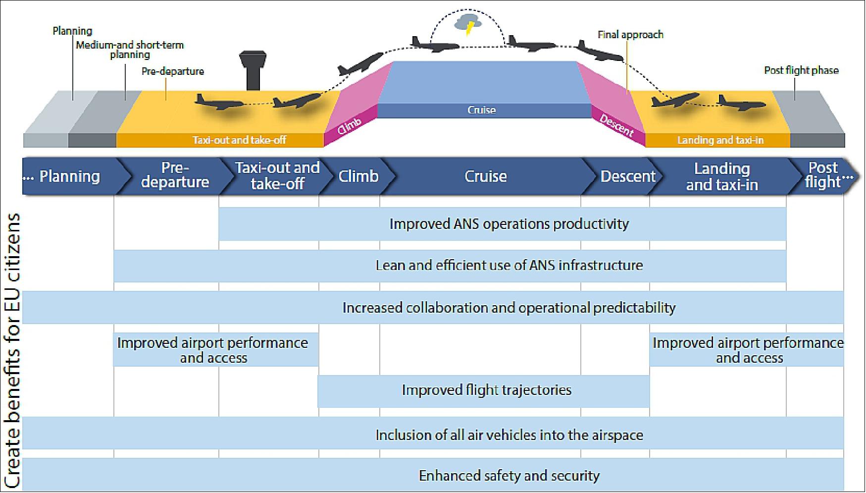
The Master Plan vision builds on the notion of ‘trajectory-based operations’ and relies on the provision of ANS (Air Navigation Services) in support of the execution of the business or mission trajectory — meaning that aircraft can fly their preferred trajectories without being constrained by airspace configurations. This vision is enabled by a progressive increase of the level of automation support, the implementation of virtualization technologies as well as the use of standardized and interoperable systems.
The system infrastructure will gradually evolve with digitization technology, allowing ANSPs (Air Navigation Service Providers), irrespective of national borders, to plug in their operations where needed, supported by a range of information services. Airports will be fully integrated into the ATM network level, which will facilitate and optimize airspace user operations. Going beyond 2035 towards 2050, performance-based operations will be implemented across Europe, with multiple options envisaged, such as seamless coordination between ANSPs or full end-to-end ANS provided at network level.
Furthermore, it is widely recognized that to increase performance, ATM modernization should look at the flight as a whole, within a flow and network context, rather than segmented portions of its trajectory, as is the case today. With this in mind, the vision will be realized across the entire ATM system, offering improvements at every stage of the flight.
NextGen (Next Generation Air Transportation System) of USA
NextGen is an effort begun in 2003 whose goals include improving the capacity, efficiency, and safety of the U.S. air transportation system and also enabling reduction in noise, pollution, and energy use. FAA (Federal Aviation Administration) and various stakeholders, including equipment providers, airlines, and contractors, are currently implementing both near-term and mid-term NextGen capabilities. The Federal Aviation Administration Modernization and Reform Act of 2012 calls for the NRC (National Research Council) to examine NextGen’s enterprise software development approach and safety and human factor design. The NRC assembled a committee of experts to study the issue. 26)
In the course of the committee’s study, it became clear that “NextGen” means different things to different people, ranging from a wide-ranging transformational vision to a much more concrete set of phased incremental changes to various parts of the NAS (National Airspace System) . In the committee’s view, NextGen is a set of programs to implement a suite of incremental changes to the NAS.
Background on FAA's Modernization Efforts for ATC (Air Traffic Control) 27)
In 2017, the U.S. NAS (National Airspace System) handles nearly 70,000 flights a day and is generally considered the safest, busiest and most complex airspace system in the world. Key aviation stakeholders—the FAA (Federal Aviation Administration), airlines, airports, general aviation, business aviation, aircraft manufacturers, and aviation professionals—work together to ensure these results. As part of this effort, FAA is leading the development of the NextGen (Next Generation Air Transportation System ), a complex, long-term initiative that will transition the current ground-based radar air-traffic control system to a system based on satellite navigation, automated position reporting, and digital communications. NextGen is intended to, among other things, increase air transportation system capacity, enhance airspace safety, reduce delays experienced by airlines and passengers, save fuel, and reduce adverse environmental impacts from aviation. Full implementation of NextGen requires investment by the federal government through FAA, as well as by airlines in new technologies and the development of new policies and procedures.
FAA has pursued several different modernization efforts for air traffic control (ATC) since FAA’s creation by the Federal Aviation Act of 1958. These efforts to upgrade the air-traffic control system included the installation of a semi-automated air-traffic control system beginning in the mid-1960s and an air traffic control modernization program beginning in 1981. The 1981 modernization program was intended to replace and upgrade the equipment and facilities of the NAS to meet an expected increase in traffic volume, enhance the margin of air safety, and increase the efficiency of the air-traffic control system. The centerpiece of the program was the Advanced Automation System, which would replace computer hardware and software and controller work stations at tower, terminal, and en-route facilities.
FAA restructured the automation program in 1994 after the estimated cost to deploy it had tripled, capabilities were shown to be significantly less than promised, and delays were expected to run nearly a decade. In 1995, we placed FAA’s air traffic control modernization efforts on our watch list of high-risk federal programs due to the cost, complexity, criticality to FAA’s mission, and problematic history. By 2003, the estimated cost of FAA’s air-traffic control modernization efforts had grown from $12 billion to $51 billion.
In the early 2000s, the U.S airspace system was experiencing significant congestion and delays, with about one in every four flights delayed. Additionally, forecasts called for a possible tripling of air traffic by 2025, which raised concerns about the air-traffic control system’s ability to handle demand. In December 2003, Congress passed the Vision 100—Century of Aviation Reauthorization Act, which created the JPDO (Joint Planning and Development Organization) within FAA to plan for and coordinate a transition to NextGen by 2025. Congress’s goals for NextGen were to improve the level of safety, security, efficiency, quality, and affordability of the NAS and aviation services; take advantage of data from emerging technologies and integrate data streams from multiple sources; and accommodate and encourage substantial growth in domestic and international transportation, among other things.
Congress assigned the JPDO the responsibility to develop an integrated plan for NextGen and facilitate collaboration between FAA and other federal agencies on NextGen efforts. Since passage of the Vision 100 Act, NextGen has evolved from a high-level vision developed by the JPDO to detailed plans currently being implemented by FAA.
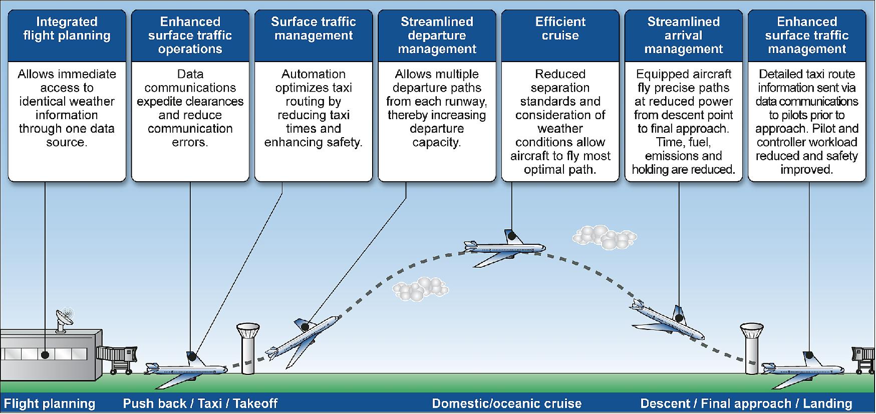
NextGen is a system of systems designed to improve operations in all phases of a flight, through the replacement of the legacy radar-based air traffic control system with a satellite-based system that includes digital communications, among other improvements. NextGen includes a variety of programs that deliver specific improvements to the NAS. For example, under enhanced-surface-traffic operations, a service provided by FAA’s Data Communications program allows an air traffic controller to send flight-departure clearance instructions to aircraft electronically, which can expedite clearances and reduce communication errors. Under an improvement to streamline arrival management, performance-based navigation allows aircraft equipped with appropriate technology to fly precise paths at reduced power, which saves time, conserves fuel, and reduces exhaust emissions. In addition, FAA is deploying some programs that are necessary to implement NextGen programs. For example, the En Route Automation Modernization (ERAM) program replaced the computer system used by air traffic controllers at en route centers, a step that was necessary to deploy some NextGen programs. Figure 15 provides some of the improvements to the phases of flight that NextGen is expected to deliver.
An important and necessary part of NextGen is addressing urgent requirements to replace aging equipment. NextGen also includes efforts to further deploy performance-based navigation, to redesign certain aspects of the airspace, to equip aircraft with technology that can form the basis for future capabilities, and an additional broad range of activities. However, NextGen does not set out a series of planned steps toward a fundamentally-transformed end-state.
Enterprise Architecture: An enterprise architecture supports and documents existing systems and business processes. The current NextGen enterprise architecture appears to be a set of functional enclaves that are providing individual services, described in a set of documents at the NAS enterprise architecture level. This tacit architecture is bottom-up and program-driven. This approach to enterprise architecture is not an adequate technical foundation for steering NextGen’s technical governance and managing the inevitable changes in technology and operations.
System Architecture: A system architecture models and defines the structure and behavior of a system in a way that supports reasoning about the system and its characteristics. A system architecture for the NAS should help ensure proper operation of the system, allow proper analyses for prediction of system behavior, performance, and so on, and ensure future evolvability. The current NAS system architecture is not well-developed, though this is difficult to discern because of the nearly exclusive focus by the FAA on the enterprise architecture.
NextGen capabilities continue to bring positive effects to the aviation industry and the flying public all across the National Airspace System (NAS). The FAA and the aviation industry work together through the NAC (NextGen Advisory Committee) to identify high-benefit, high-readiness NextGen capabilities for implementation in the near term. This work began in 2014 by identifying four focus areas — Multiple Runway Operations (MRO), Performance Based Navigation (PBN), Surface Operations and Data Sharing, and Data Communications (Data Comm). The FAA and the aviation industry identified specific capabilities to implement at specific locations in the 2014–2017 timeframe and documented both FAA and industry commitments in the FAA’s NextGen Priorities Joint Implementation Plan. 28)
The FAA and industry are committed to jointly evaluating the effects of these commitments on the NAS through the work of a JAT (Joint Analysis Team). This helps the FAA and industry understand the value of implementations in this plan.
Given the success of this collaboration, the FAA and industry agree to keep collaborating through the NAC to update the commitments each year and roll the plan forward biannually. The commitments in this plan reflect the culmination of work through 2019. Both the FAA and industry have identified specific commitments within each of the four focus areas to implement capabilities at specific locations by specific dates to increase safety, reduce aviation’s impact on the environment, enhance controller productivity, and increase predictability, airspace capacity and efficiency. The FAA and industry will continue to monitor joint progress and be agile and flexible to make necessary adjustments to commitments.
Accomplishments were realized in all four focus areas:
• The FAA made substantial progress on Wake Recategorization (Wake RECAT) implementation at locations with simultaneous approaches to parallel runways by reducing separation criteria for multiple runway operations. RECAT was refined with additional separation reductions that are currently implemented at all RECAT sites across the NAS. The FAA also successfully addressed separation standards for multiple dependent and independent parallel operations at numerous locations and completed safety analyses for a variety of other separation standards. To date, the Wake RECAT capabilities identified positive effects on the NAS with capabilities delivering benefits as anticipated. For example, the JAT’s operational performance findings on Charlotte’s Wake RECAT implementation estimated $237,000 in total annual savings in airborne and taxi out time.
• In the critical area of PBN, the FAA increased its community outreach at Charlotte by holding two public workshops to discuss flight path changes for routes northeast and southeast of the city. The FAA implemented 11 procedures at Charlotte, with 10 more to be implemented in early 2017. The agency also completed a Metroplex implementation at Northern California, implemented Established on RNP (EoR) capabilities at Denver, published the EoR National Standard, and conducted a single site assessment for Las Vegas.
• As an early implementation activity, the Terminal Flight Data Manager (TFDM) Program funded the Traffic Flow Management System (TFMS) Release 13 to enable the addition of new surface data elements. This modification was implemented in April 2016 and included changes to the data use hierarchy so that near-term “early implementation” benefits in TFMS will be realized. The FAA is now able to ingest and use several data elements in TFMS that will yield TFM (traffic flow management) benefits with better traffic management initiatives and increased predictability for the customers and the system. The FAA made the investment in early implementation given industry's commitment to provide the data, and there is a concerted effort underway with industry to provide data. The FAA also deployed electronic flight strips at Newark, Las Vegas and San Francisco.
• The FAA has made significant progress in Data Comm and is on track to complete Departure Clearance Tower Services at 56 airports by the end of Calendar Year 2016. Our industry partners are well on their way toward the goal of 1,900 Data Comm-equipped aircraft operating in the NAS by the end of CY 2019. More than 900 Data Comm-equipped aircraft currently operating (as of August 2016) were equipped through the FAA’s Data Comm equipage initiative.
Harmonization between NextGen and SESAR
As two of the major aviation modernization programs in the world, the NextGen program of the FAA (Federal Aviation Administration) and SESAR have a shared interest and responsibility in harmonization as a means of ensuring global interoperability. The two programs have common challenges and a similar conceptual and performance-driven approach. It is widely understood that systems will not be completely identical but harmonized and interoperable at the standard level. SESAR and NextGen advocate a ‘not-one-size-fits-all’ approach in both the US and in Europe as well as at ICAO (International Civil Aviation Organization) level. This is globally accepted and the aim is to achieve the degree of harmonization necessary to:
• ensure aircraft can operate in all regions (without requiring additional equipment);
• ensure that common standards are available when needed and in time for both development and implementation planning;
• optimize development and implementation costs through the sharing of effort and results.
The scope of what should be harmonized is derived from the agreed ICAO global ATM operational concept developed by the entire global aviation community and complemented with new requirements expressed by the ATM stakeholders, in particular airspace users.
The US-EU MoC (Memorandum of Cooperation) on civil aviation research and specifically Annex 1 on SESAR-NextGen interoperability is the important vehicle for harmonization between these two major modernization programs and their results directly contribute to the development of global harmonization initiatives under the umbrella of ICAO, the industry standardization bodies of RTCA (Radio Technical Commission for Aeronautics) and EUROCAE (European Organization for Civil Aviation Equipment), as well as with other relevant international standardization organizations. The MoC as such also constitutes the collaborative framework within which the US and the EU develop and establish joint or supporting positions on standards and priorities in the ICAO work program, while allowing other regions to share information and where possible participate in the different domains of the MoC.
The SESAR and NextGen programs are aligned with and support ICAO’s GANP (Global Air Navigation Plan) and the ASBUs (Aviation System Block Upgrades). The two programs both impact and are impacted by the GANP in terms of ICAO priorities. Looking ahead, the focus is to further align the two programs’ priorities supporting a further evolution of the GANP, namely its update in 2016 and 2019 (Ref. 24).
High-level frameworks have been established and are now being complemented with further agreements at a more detailed level (e.g. harmonized planning and standard proposals to industry standardization organizations and ICAO).
References
1) ”Satellite Communication for Air Traffic Management (Iris) Overview,” ESA ARTES Applications, URL: https://artes.esa.int/iris/overview
2) “Iris - the satellite-based communication solution for the Single European Sky Air Traffic Management Research program,” ESA brochure, 2010, URL: http://www.evolvsys.cz/files/brochures/esa/Iris.pdf
3) “Overview of ARTES 10 - Iris,” ESA, URL: http://artes.esa.int/artes-10/overview
4) ”easyJet signs up for space-enabled digital skies,” ESA Applications, 21 June 2022, URL: https://www.esa.int/Applications/Telecommunications_Integrated_Applications/easyJet_signs_up_for_space-enabled_digital_skies
5) ”Iris system to digitalise airspace goes global,” ESA Applications, 9 June 2022, URL: https://www.esa.int/Applications/Telecommunications_Integrated_Applications/Iris_system_to_digitalise_airspace_goes_global
6) ”ESA acts to make air travel greener,” ESA Applications, 27 October 2021, URL: https://www.esa.int/Applications/Telecommunications_Integrated_Applications/ESA_acts_to_make_air_travel_greener
7) ”Flight trials for greener aviation set for take off,” ESA Applications, 19 June 2020, URL: http://www.esa.int/Applications/Telecommunications_Integrated_Applications/Flight_trials_for_greener_aviation_set_for_take_off
8) ”Satellite-enabled air traffic control system takes to the skies,” ESA, 3 October 2019, URL: http://www.esa.int/Our_Activities/Telecommunications_Integrated_Applications/Satellite-enabled_air_traffic_control_system_takes_to_the_skies
9) ”Space tech poised to make air travel greener and more efficient,” ESA, 13 March 2019, URL: http://m.esa.int/Our_Activities/Telecommunications_Integrated_Applications/Space_tech_poised_to_make_air_travel_greener_and_more_efficient
10) ”Agreements signed with Europe’s leading ANSPs for Iris,” Inmarsat, 21 November 2018, URL: https://www.inmarsat.com/news/agreements-signed-with-europes-leading-ansps-for-iris/
11) ”Iris flight trial,” ESA, 21 November 2018, URL: http://m.esa.int/spaceinimages/Images/2018/07/Iris_flight_trial4
12) ”Inmarsat Goes Pro Iris and Signs Five Air Navigation Services Providers,” Satnews Daily, 27 November 2018, URL: http://www.satnews.com/story.php?number=1705135736
13) ”SESAR Deployment Manager and European Space Agency sign Memorandum of Cooperation,” SESAR, 19 July 2018, URL: https://www.sesardeploymentmanager.eu/sesar-deployment-manager-and-european-space-agency-sign-memorandum-of-coordination/
14) ”Iris flight trial,” ESA, 12 July 2018, URL: http://m.esa.int/spaceinimages/Images/2018/07/Iris_flight_trial3
15) ”Iris system takes first flight,” ESA, 17 July 2018, URL: http://m.esa.int/Our_Activities/Telecommunications_Integrated_Applications/Iris_system_takes_first_flight
16) ”ESA to clear congested skies with Iris,” ESA, 17 Jan. 2018, URL: http://m.esa.int/Our_Activities/Telecommunications_Integrated_Applications/ESA_to_clear_congested_skies_with_Iris
17) ”Preparing for air traffic control via satellite,” ESA, Dec. 20, 2016, URL: http://m.esa.int/Our_Activities/Telecommunications_Integrated_Applications/Preparing_for_air_traffic_control_via_satellite
18) ”Inmarsat and European Space Agency Complete First Test Flights for Air Traffic Modernization Project,” Dec. 20, 2016, URL: http://airfax.com/blog/index.php/2017/01/02/inmarsat-and-european-space-agency-complete-first-test-flights-for-air-traffic-modernisation-project/
19) ”European cooperation for safer skies,” ESA, Sept. 15, 2016, URL: http://m.esa.int/Our_Activities/Telecommunications_Integrated_Applications/European_cooperation_for_safer_skies
20) ”Single European Sky – DLR and NLR join the 2020 SESAR research program,” DLR News, March 9, 2016, URL: http://www.dlr.de/dlr/en/desktopdefault.aspx/tabid-10081/151_read-17065/year-all/#/gallery/22290
21) ”Space keeps us safe as air travel rises,” ESA, March 8, 2016, URL: http://www.esa.int/Our_Activities/Telecommunications_Integrated_Applications/Space_keeps_us_safe_as_air_travel_rises
22) “Europe advances with safer air travel,” ESA, July 14, 2015, URL: http://www.esa.int/Our_Activities/Telecommunications_Integrated_Applications/Europe_advances_with_safer_air_travel
23) “Building a safer airspace for Europe,” ESA, Nov. 26, 2014, URL: http://www.esa.int/Our_Activities/Telecommunications_Integrated_Applications/Building_a_safer_airspace_for_Europe/%28print%29
24) ”SESAR — European ATM Master Plan,” EU, Eurocontrol, Edition 2015, URL: https://www.atmmasterplan.eu/downloads/202
25) Commission Implementing Regulation EU No 409/2013 specified the requirements for common projects. Common projects aim to deploy in a timely, coordinated and synchronized way ATM functionalities that are mature for implementation and that contribute to the Essential Operational Changes identified in the European ATM Master Plan (2012 edition). The first of these common projects is the PCP (Pilot Common Project).
26) ”A Review of the Next Generation Air Transportation System: Implications and Importance of System Architecture,” Computer Science and Telecommunications Board , Division on Engineering & Physical Sciences, May 2015, URL: http://sites.nationalacademies.org/cs/groups/depssite/documents/webpage/deps_161390.pdf
27) Bill Shuster, Peter De Fatio, Frank LoBiondo, Rick Larsen, ”Air Traffic Control Modernization - Progress and challenges in implementing NextGen,” United States Government Accountability Office, Report to Congress, August 2017, URL: https://www.gao.gov/assets/690/686881.pdf
28) ”NextGen Priorities Joint Implementation Plan, Rolling Plan 2017-2019,” 23 Sept. 2016, URL: https://www.faa.gov/about/office_org/headquarters_offices/ang/nac/media/NG_Priorities_Joint_Implementation_Plan.pdf
The information compiled and edited in this article was provided by Herbert J. Kramer from his documentation of: ”Observation of the Earth and Its Environment: Survey of Missions and Sensors” (Springer Verlag) as well as many other sources after the publication of the 4th edition in 2002. - Comments and corrections to this article are always welcome for further updates (eoportal@symbios.space).