GHG-CCI (Greenhouse Gas-Climate Change Initiative)
Applications
GHG-CCI (Greenhouse Gas-Climate Change Initiative)
The GHG-CCI project is one of several projects of ESA's (European Space Agency) CCI (Climate Change Initiative). The goal of the CCI is to generate and deliver data sets of various satellite-derived ECVs (Essential Climate Variables) in line with GCOS (Global Climate Observing System) requirements. The ECV Greenhouse Gases is the global distribution of important climate relevant gases – namely atmospheric CO2 and CH4 - with a quality sufficient to obtain information on regional CO2 and CH4 sources and sinks. The main goal of GHG-CCI is to generate long-term highly accurate and precise time series of global near-surface-sensitive satellite observations of CO2 and CH4, i.e., XCO2 (Mole Fraction Carbon Dioxide) and XCH4, starting with the launch of ESA's ENVISAT satellite. 1) 2)
These products are currently retrieved from SCIAMACHY/ENVISAT (2002-2012) and TANSO-FTS/GOSAT (2009-today) nadir mode observations in the near-infrared/shortwave-infrared spectral region. In addition, other sensors (e.g., IASI and MIPAS) are also considered and in the future also data from other satellites. The GHG-CCI data products and related documentation are freely available via the GHG-CCI website (http://www.esa-ghg-cci.org/). Here, an overview is presented about the latest data set CRDP#2 (Climate Research Data Package No. 2) focusing on the GHG-CCI core products and present a short overview about GHG-CCI-related achievements in terms of scientific publications.
Carbon dioxide (CO2) is the most important anthropogenic greenhouse gas responsible for global warming [IPCC (Intergovernmental Panel on Climate Change), 2013]. 3) - Despite its importance, our knowledge of the CO2 sources and sinks is inadequate and does not meet the needs for attribution, mitigation and the accurate prediction of future change. Despite efforts to reduce CO2 emissions, atmospheric CO2 continues to increase with approximately 2 ppm/year (Figure ). Appropriate knowledge about the CO2 sources and sinks is needed for reliable prediction of the future climate of our planet (IPCC, 2013). This is also true for methane CH4. Global near-surface-sensitive satellite observations of CO2 and CH4 combined with inverse modeling yields information on the regional sources and sinks of these gases.
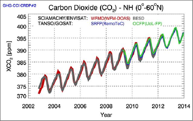
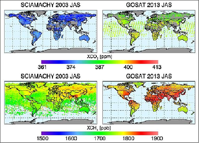
Legend to Figure 1: Clearly visible is the CO2 seasonal cycle - primarily caused by uptake and release of CO2 by the terrestrial biosphere - and the atmospheric CO2 increase with time, which is primarily caused by burning of fossil fuels (fraction not taken up by the terrestrial biosphere or the oceans). Also visible is the good agreement of the different GHG-CCI CRDP#2 XCO2 data products. Corresponding XCO2 and XCH4 maps are shown in Figure 2.
Multi-year measurements from two satellite instruments can be used to retrieve information on CO2 and CH4 with sufficient near-surface-sensitivity: SCIAMACHY on ENVISAT (2002 - April 2012) and TANSO-FTS on-board GOSAT (launched in 2009). Both instruments perform (or have performed) nadir observations in the NIR/SWIR (Near Infrared/Shortwave Infrared) spectral region covering the relevant absorption bands of CO2, CH4 and O2 [needed to obtain the "dry-air column" used to compute the GHG column-averaged dry-air mole fractions, i.e., XCO2 (in ppm) and XCH4 (in ppb)]. These two instruments are therefore currently the two main sensors used within GHG-CCI. The corresponding retrieval algorithms are referred to as ECAs (ECV Core Algorithms) within GHG-CCI.
In addition, a number of other sensors are also used within GHG-CCI (e.g., MIPAS/ENVISAT and IASI/MetOp-A) as they provide additional constraints for atmospheric layers above the planetary boundary layer. The corresponding retrieval algorithms are referred to as ACAs (Additional Constraints Algorithms) within GHG-CCI.
Even moderate to strong CO2 and CH4 sources and sinks only result in quite small changes of the column-averaged mole fractions relative to their background concentration. High relative accuracy of the satellite retrievals is required because even very small (regional) biases can lead to significant errors of the inferred surface fluxes. One of the first activities within GHG-CCI was to establish the user requirements, e.g., in terms of required accuracy and precision of the different data products. The result of this activity was the initial version of the GHG-CCI URD (User Requirements Document). Note that the GHG-CCI URD requirements are more detailed and often also more demanding compared to the GCOS requirements.
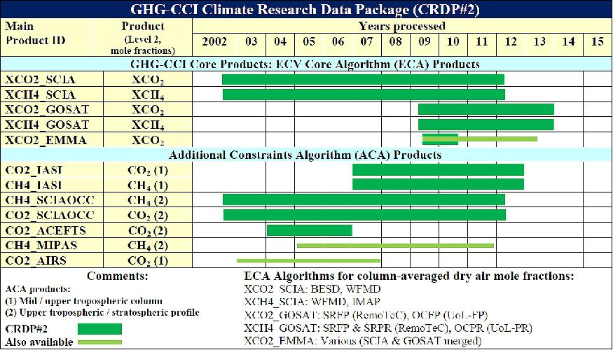
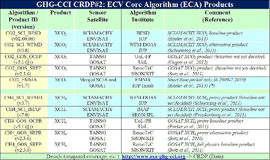
An overview about the various satellite-derived data products stored in the CRDP#2 data base is shown in Table 1, providing a general overview for ECA and ACA products, and Table 2, providing details on ECA products.
Ongoing Activities and Future Plans
Currently (May 2015) GHG-CCI team members are working on further improving the retrieval algorithms to be used for re-processing of the satellite data. The next version of the GHG-CCI Climate Research Data Package, CRDP#3, will be released in April 2016 (including documentation on validation PVIR (Product Validation and Intercomparison Report) and initial user assessments (CAR (Climate Assessment Report).
GHG-CCI retrieval experts are also members of the OCO-2 (Orbiting CarbonObservatory-2) Science Team and involved in the development of retrieval algorithms for Sentinel-5P and the data products of these sensors will also be considered by GHG-CCI. For OCO-2 of NASA, it is initially planned to perform detailed comparisons to determine the consistency of the XCO2 data products and to perform initial retrievals.
GHG-CCI team members are also involved in the specification of future GHG satellites, in particular CarbonSat, a proposed mission of ESA. CarbonSat, if selected for ESA's Earth Explorer 8 satellite, will continue the time series of greenhouse gas observations from space presented in this manuscript, but will also address many important new aspects which cannot (or only with severe limitations) be addressed with other existing or planned satellites in particular the detection of localized CO2 and CH4 sources and the quantification of their emissions. Like SCIAMACHY, GOSAT and OCO-2, sun induced chlorophyll fluorescence, SIF, will be a secondary data product from CarbonSat, which can be linked to GPP (Gross Primary Production) and for investigating the impact of stress on vegetation and the CO2 uptake at the few km2 spatial resolution scale of CarbonSat.
The main goal of CarbonSat is to advance our knowledge on the natural and man-made sources and sinks of the two most important anthropogenic greenhouse gases carbon dioxide and methane from the global via the subcontinental to the local scale. CarbonSat will be the first satellite mission to image small scale emission hot spots of CO2 (e.g., cities, volcanoes, industrial areas) and CH4 (e.g., fossil fuel production, landfills, seeps) and to quantify their emissions and discriminate them from surrounding biospheric fluxes.
Permafrost CCI Project
Permafrost is a phenomenon of the subsurface thermal state and is defined as ground at or below the freezing point of water for two or more years. Permafrost underlies approximately one quarter of the terrestrial Northern Hemisphere. From borehole temperature data and active layer depth measurements we know that over the past three decades permafrost has been warming, and continues to warm, across the circumpolar North. Changing permafrost interacts with ecosystems and climate on various spatial and temporal scales. Environmental changes accelerate the microbial breakdown of organic carbon and the release of the greenhouse gases carbon dioxide and methane what can accelerate climate change. Monitoring across scales is required in order to quantify the changes of variations in this ECV(Essential Climate Variable). 4)
Permafrost cannot be directly detected from space, but many surface features of permafrost terrains and typical periglacial landforms are observable with a variety of EO sensors ranging from very high to medium resolution in various wavelengths. In addition, landscape dynamics associated with permafrost changes and geophysical variables relevant for characterizing the state of permafrost, such as land surface temperature or snow-water equivalent, can be observed with space-based Earth Observation. Permafrost_cci will provide for different epochs consistent global maps of the parameters permafrost temperature and active layer thickness based on Earth Observation records ingested into a permafrost model scheme.
Objective: The ultimate objective of Permafrost_cci is to develop and deliver permafrost maps as ECV products primarily derived from satellite measurements. The required associated parameters by GCOS for the ECV Permafrost are "Depth of active layer (m)" and "Permafrost temperature (K)". Algorithms have been identified which can provide these parameters ingesting a set of global satellite data products: LST (Land Surface Temperature), SWE (Snow Water Equivalent, and landcover) in a permafrost model scheme that computes the ground thermal regime. In Permafrost_cci we will strongly rely on data products from recent, ongoing and future ESA projects (e.g. LST_cci, Snow_cci), which offer consistency over several satellite generations. Validation and evaluation efforts comprise comparison to in-situ measurements of subsurface properties(active layer depth,active layer and permafrost temperatures,organic layer thickness, liquid water content in the active layer and permafrost) and surface properties (vegetation cover, snow depth, surface and air temperatures) as well as rock glacier inventories, local permafrost maps and geophysical survey measurements.
References
1) M. Buchwitz, M. Reuter, O. Schneising, H. Boesch, I. Aben, M. Alexe, R. Armante, P. Bergamaschi, H. Bovensmann, D. Brunner, B. Buchmann, J. P. Burrows, A. Butz, F. Chevallier, A. Chédin, C. D. Crevoisier, M. De Mazière, E. De Wachter, R. Detmers, B. Dils, C. Frankenberg, S. Gonzi, P. Hahne, O. P. Hasekamp, W. Hewson, J. Heymann, S. Houweling, M. Hilker, T. Kaminski, G. Kuhlmann, A. Laeng, T. T. v. Leeuwen, G. Lichtenberg, J. Marshall, S. Noël, J. Notholt, P. I. Palmer, R. Parker, P. Somkuti , M. Scholze, G. P. Stiller, T. Warneke, C. Zehner, "The Greenhouse Gas Project of ESA's Climate Change Initiative (GHG-CCI): Phase 2 Achievements and Future Plans," Proceedings of ATMOS 2015 (Advances in Atmospheric Science and Applications), Heraklion, Greece, June 8-12, 2015, ESA SP-735, November 2015
2) M. Buchwitz, M. Reuter, O. Schneising, H. Boesch, I. Aben, M. Alexe, R. Armante, P. Bergamaschi, H. Bovensmann, D. Brunner, B. Buchmann, J. P. Burrows, A. Butz, F. Chevallier, A. Chédin, C. D. Crevoisier, M. De Mazière, E. De Wachter, R. Detmers, B. Dils, C. Frankenberg, S. Gonzi, P. Hahne, O. P. Hasekamp, W. Hewson, J. Heymann, S. Houweling, M. Hilker, T. Kaminski, G. Kuhlmann, A. Laeng, T. T. v. Leeuwen, G. Lichtenberg, J. Marshall, S. Noël, J. Notholt, P. I. Palmer, R. Parker, P. Somkuti , M. Scholze, G. P. Stiller, T. Warneke, C. Zehner, "The Greenhouse Gas Project of ESA's Climate Change Initiative (GHG-CCI): Phase 2 Achievements and Future Plans," The International Archives of the Photogrammetry, Remote Sensing and Spatial Information Sciences, Volume XL-7/W3, 2015, 36th International Symposium on Remote Sensing of Environment, 11–15 May 2015, Berlin, Germany, URL: http://www.esa-ghg-cci.org/?q=webfm_send/262
3) Thomas F. Stocker, Dahe Qin,Gian-Kasper Plattner, Melinda M.B. Tignor, Simon K. Allen, Judith Boschung, Alexander Nauels, Yu Xia, Vincent Bex, Pauline M. Midgley, "IPCC, Climate Change 2013: The Physical Science Basis, Working Group I Contribution to the Fifth Assessment," Report of the Intergovernmental Report on Climate Change, URL: http://www.climatechange2013.org/images/report/WG1AR5_ALL_FINAL.pdf
4) Fay Done, "Permafrost CCI Project," CCI (Climate Change Initiative), 22 May 2018, URL: http://cci.esa.int/Permafrost#news
The information compiled and edited in this article was provided by Herbert J. Kramer from his documentation of: "Observation of the Earth and Its Environment: Survey of Missions and Sensors" (Springer Verlag) as well as many other sources after the publication of the 4th edition in 2002. - Comments and corrections to this article are always welcome for further updates (eoportal@symbios.space).