GaoJing / SuperView Earth Observation Constellation
EO
Operational (nominal)
Beijing Space View Technology Co. Ltd
GaoJing/SuperView is a Chinese commercial imaging satellite constellation, which aims to provide a wide range of commercial very-high-resolution (VHR) imaging applications to its customers.
Quick facts
Overview
| Mission type | EO |
| Agency | Beijing Space View Technology Co. Ltd |
| Mission status | Operational (nominal) |
| Launch date | 28 Dec 2016 |
| CEOS EO Handbook | See GaoJing / SuperView Earth Observation Constellation summary |
Summary
Mission Capabilities
The GaoJing/SuperView-1 satellites are the first VHR remote sensing satellites made in China. They feature a pushbroom imager with TDI (Time Delay Integration) capability, operating at panchromatic and multispectral resolutions of 0.5 m and 2 m, respectively.
Imagery from the satellites’ optical instrument is distributed for mapping, land use, urban planning, agricultural, oil and gas exploration, maritime, security, defence and intelligence applications.
Performance Specifications
A single GaoJing/SuperView-1 satellite is capable of imaging an area of 700,000 km2 per day. They have a 12 km swath at nadir with a data positioning accuracy of less than or equal to 20 m.
Both pairs of satellites operate in sun-synchronous orbits at an altitude of 530 km, inclined at 98° and have a revisit period of 4 days. The second pair of satellites, GaoJing/SuperView-1 03 and 04, were launched into a coplanar orbit with the initial pair of satellites, creating a phasing of 90° for the constellation.
Space and Hardware Components
The GaoJing/SuperView minisatellites are based on the CAST3000B light agile platform designed and developed by the China SpaceSat Co. Ltd. of Beijing, which allows up to ±30° manoeuvres and ±45° roll down in emergency scenarios. The satellites have a launch mass of 560 kg and a design life of 8 years. RF communications have downlink in X-band in two, 450 Mbit/s bands.
The satellites are a part of the SuperView network, which contains at least 24 Earth observation satellites and is expected to become one of the world’s largest commercial providers of space imagery and geospatial data.
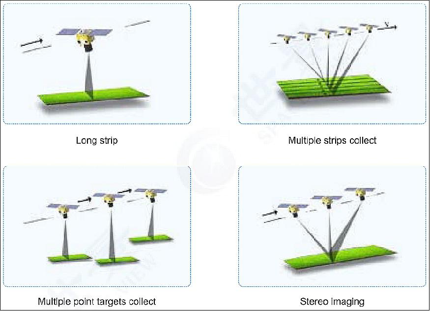
The SuperView-1 constellation images in multiple modes, such as imaging at nadir, rolling imaging, long strip, multiple strip collect, multiple target collect and stereo imaging. The multiple strip mode uses the VHR imagers with a combined large swath width, providing applications including DEM (Digital Elevation Model) production.
GaoJing / SuperView Earth Observation Constellation
Spacecraft Launch Mission Status Sensor Complement References
GaoJing / SuperView-1 and -2 is a commercial constellation of Chinese remote sensing satellites operated by Beijing Space View Technology Co. Ltd., China.
Space View Technology has been granted the distribution of imagery of Chinese satellites by the Chinese government, including GF-2 (Gaofen-2), GF-1, ZY-3 (Zi Yuan-3) and HJ-1A&B (Huan Jing-1) in the global market since 2014. The establishment of an integrated RS (Remote Sensing) satellite data trading platform and data bank meets various demands from governments, enterprises, Internet and mobile end users. 1)
The objective of the SuperView satellites is to provide imagery with 0.5 m panchromatic resolution and 2 m multispectral resolution on a swath of 12 km. The spacecraft is very agile providing multiple collection modes including long strip, multiple strips collect, multiple point targets collect and stereo imaging. The maximum single scene can be 60 km x 70 km of video data.
Background
Space View has two business entities — Beijing Space View Technology Co. Ltd. and Siwei WorldView Technology (Beijing) Co. Ltd.
Beijing Space View Technology Co. Ltd. is a government-certified Hi-Tech Enterprise. It is controlled by China Siwei Surveying and Mapping Technology Co. Ltd.
Siwei WorldView Technology (Beijing) Co. Ltd. is a joint venture founded by China Siwei Surveying and Mapping Technology Co. Ltd., DigitalGlobe Inc. and Navinfo. It is the main distributor in China for DigitalGlobe's WorldView-1, -2 and -3, GeoEye-1, QuickBird and Ikonos, Korean KOMPSAT-2, -3, 3A and -5, Japanese ALOS, Spanish Deimos-1 and -2 and Kazakhstan KazEOSat-1, etc. 2) 3)
As a subsidiary of CASC (China Aerospace and Science Corporation), Space View has always shouldered responsibilities to promote applications and distribution of China EO satellite data. So far, Space View has successfully distributed massive data GF-1, -2, ZY-3, HJ-1A, 1B and more in the markets.
Siwei Star Co. Ltd. is the owner and operator of the GoaJing/SuperView constellation. It is held by Siwei Surveying and Mapping Technology Co. Ltd., a subsidiary of CASC. Beijing Space View Technology Co. Ltd. acts as the exclusive global distributor of the SuperView satellite data.
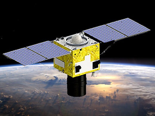
Spacecraft
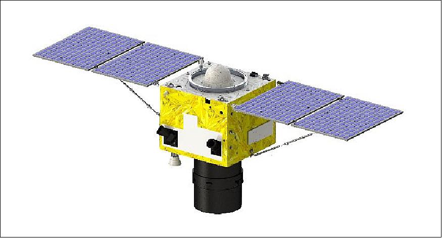
The commercial GaoJing / SuperView minisatellites are based on the CAST3000B light agile platform designed and developed by the China SpaceSat Co. Ltd. of Beijing [also referred to as DFH (Dongfanghong) Satellite Co. Ltd.], the commercial subsidiary of CAST (Chinese Academy of Space Technology) which belongs to CASC (China Aerospace and Science Corporation), the main contractor for China's space program. The satellites are equipped with a pair of solar panel wings, each with two solar panels. The satellites have a launch mass of 560 kg and a design life of 8 years.
On September 2015, CASC announced to start of the construction of a commercial remote sensing satellite constellation, including 16 optical satellites with 0.5 m GSD (Ground Sample Distance). The 4 optical satellites with 0.5 m GSD, developed in the first stage of this project, are scheduled to launch at the end of 2016 and in mid-2017. Based on mature technology, the satellites meet the needs for professional and quantitative applications. The camera's MTF (Modulation Transfer Function) is better than 0.15, with digital quantization of 11bit and the nadir swath width of more than 12 km. Its great agile capability contributes to target imaging, stereo imaging and five-strip imaging. 4)
The very agile platform of the satellites allows up to ±30º manoeuvres and ±45º roll down in emergency scenarios. This is very beneficial to the multiple collection modes of the spacecraft. An onboard data collection capacity of 2 TB is available, sufficient to store up to 700,000 km2 of imagery in one day.
RF communications: The downlink is in X-band in two bands, each at 450 Mbit/s.
Launch
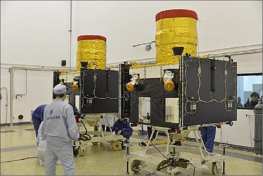
The first pair of GaoJing minisatellites, SuperView-1 01 and Superview-1 02, was launched on December 28, 2016 (3:23:56 UTC) on a CZ-2D vehicle from TSLC (Taiyuan Satellite Launch Center), located in the Shanxi Province of China. 5) 6)
Orbit: Sun-synchronous orbit, altitude of 530 km, inclination = 98º, LTDN (Local Time on Descending Node) = 10:30 hours, period of 97 minutes. The two satellites will be phased to 180º. The revisit time is 4 days.
Secondary payload:
• Bayi Kepu Weixing-1, a 2U CubeSat (2 kg) of the China Association for Science and Technology, an educational payload with amateur radio equipment onboard.
By mid-2017, the SuperView-3 and -4 satellites will be launched into the same orbit, with a phasing of 90º for the constellation.
By the year 2022, Siwei Star Co. Ltd. will have completed the GaoJing/SuperView formation of "16+4+4+X" multi-sensor commercial high-resolution satellite constellation with a strong capability to provide data and services to its clients across the world — consisting of (Ref. 4):
• 16 optical satellites with a GDS of 0.5 m
• 4 optical satellites with a GSD of better than 0.5 m
• 4 X-band SAR (Synthetic Aperture Radar) satellites
• Multiple micro video and hyperspectral satellites.
Launch: The second pair of GaoJing-1 03 /Superview-1 03 and GaoJing-1 04/Superview-1 04 minisatellites was launched on 9 January 2018 (03:24 UTC) on a Long March 2D vehicle from TSLC (Taiyuan Satellite Launch Center) in China. 7)
Orbit: Sun-synchronous orbit, altitude of 530 km, inclination = 98º, LTDN (Local Time on Descending Node) = 10:30 hours, period of 97 minutes. The two new satellites will be phased into a coplanar orbit with the pair of GaoJing-1 01 and GaoJing-1 02 launched on 28 Dec. 2016.
Mission Status
• On 5 December 2017, Beijing Space View Technology Co., Ltd. ("Space View") and UrtheCast Corp. and its subsidiary, the Earth Observation company Deimos Imaging ("Deimos Imaging") signed a strategic cooperation agreement for the mutual global distribution of the two companies' respective product portfolios. 8)
- The space assets of the two companies include the SuperView Constellation, of which currently 2 sensors have been launched, with the next 2 to be launched at the end of 2017, and Deimos imaging's Deimos-1 and Deimos-2 satellites. The collaboration will result in a wide portfolio of medium, high and very high-resolution satellites. These assets are complementary and are expected to provide customers with an exceptional level of decision-making data and to create unique and valuable benefits across a diverse group of sectors while strengthening the positions of both companies in their respective markets.
• October 13, 2017: Space View is the exclusive distributor of Chinese EO satellite data including GF series, ZY series, HJ-1A&B, and other satellites, the image resolution is from 0.5m to 500m. Meanwhile as the operator of SuperView constellation, not only does Space View manage the imaging services, but also promotes the construction of direct-receiving and virtual stations around the World. 9)
• January 12, 2017: China's first commercial high-resolution Earth observation satellite network has begun to operate, its developer CASC said. China Aerospace Science and Technology Corp, the country's main space contractor, has released several images taken by the SuperView 1A and 1B, the first two satellites in the SuperView system. 10) 11) 12)
- The two satellites are operating at an altitude of 514 km, with a panchromatic resolution of 0.5 ms and multispectral resolution of 2 m, said Zhang Xiaomin, a senior researcher at CASC, who oversees the system's development.
- The two identical satellites are part of the SuperView network of at least 24 Earth observation satellites, which CASC expects to become one of the world's largest commercial providers of space imagery and geospatial data, Yang said. He added that the whole system will be built by 2022.
- Once the network is completed, it will consist of 16 optical satellites like the SuperView 1A and 1B, four optical satellites that are more advanced, four radar satellites and several mini-satellites, according to Yang.
• January 11, 2017: The two satellites have now achieved an orbital altitude of 514 km, which is close to their planned observing positions. 13)
• December 30, 2016: While Chinese news media declared the launch of GaoJing/SuperView minisatellites a success, satellite observers noted the two spacecraft were placed into elliptical orbits ranging from 214 to ~524 km rather than the planned circular sun-synchronous orbit at an altitude of 530 km. 14)
- The two minisatellites have onboard propulsion that may allow them to raise their orbits, but at some cost to their lifetime. Also, onboard is a student-built 2U CubeSat, Bayi Kepu Weixing-1 (also referred to as BY70-1), which was deposited into the improper orbit and this spacecraft does not have any propulsion. The 2U CubeSat is expected to fall back to Earth within weeks.
- Since the launch, the two minisatellites have been gradually raising their orbits. Orbital data provided by the U.S. Air Force's Joint Space Operations Center indicated that as of early Dec. 30 one spacecraft, designated SuperView-1, is in an orbit of 352 x 526 km. The other, SuperView-2, is in an orbit of 369 x 526 km.
- Neither the owner of the SuperView satellites, Siwei Star Co. Ltd. of Beijing, nor other Chinese officials have commented on the apparent launch anomaly. Outside observers noted that the timing of several events during the launch, including the separation of the second stage from the first stage and the second stage's engine shutdown, were delayed from scheduled times by several seconds.
Sensor Complement
The SuperView 1 satellites are the first commercial "very high-resolution" Earth-observing craft made in China. A single SuperView 1 satellite can collect up to 700,000 km2 of imagery per day, according to Beijing Space View. "Different from all the Chinese Earth observation satellites launched in the last decade, our SuperView services will be totally commercial, and we will customize data collection services and develop derived products based on marketing demands," said Lily Xu, CEO of Beijing Space View, in a company statement.
Beijing Space View holds exclusive rights to distribute and sell SuperView 1 imagery globally for mapping, land use, urban planning, agricultural, oil and gas exploration, maritime, security, defence and intelligence applications.
Imager type | Pushbroom with TDI capability |
Spectral bands | PAN: 0.45-0.89 µm |
GSD (Ground Sample Distance) at nadir | PAN: 0.5 m |
Swath width at nadir | 12 km |
Detector type | CCD array |
Data quantization | 11 bit |
Data positioning accuracy | ≤ 20 m |
Imaging capacity/day | 700,000 km2 |
Provision of Multiple Collection Modes
The SuperView-1 constellation works in multiple modes, such as imaging at nadir, rolling imaging, long strip, multiple strip collect, multiple target collect and stereo imaging. The multiple strip collect mode will realize high-resolution surveying and mapping with large swath and the stereo imaging mode will provide many opportunities for DEM production.
References
1) URL: http://www.siweidg.com/english/Satellite/SuperView_1/#main
2) "Space View — A leading provider of RS satellite data and geospatial information services in China," brochure, URL: http://www.siweidg.com/brochure/SpaceView%20Brochure.pdf
3) http://www.siweidg.com/english/about/gongsijianjie/
4) Lihua Zhang, Ming Li, "The Development of Commercial Remote Sensing Satellites and LEO Communication Constellation,"67th IAC (International Astronautical Congress), Guadalajara, Mexico, Sept. 26-30, 2016, URL: http://tinyurl.com/zmv7vce
5) "China launches high-resolution remote sensing satellites," Xinhua, December 28, 2016, URL: http://www.china.org.cn/china/2016-12/28/content_39999442.htm
6) "Busy Finish to a Massive Year for China's Space Program," CAS (Chinese Academy of Sciences), Dec. 14, 2016, URL: http://english.cas.cn/newsroom/news/201612/t20161214_172257.shtml
7) Andrew Jones, "First Chinese launch of 2018 puts two SuperView-1 observation satellites into low Earth orbit," gbtimes, 9 Jan. 2018, URL: https://web.archive.org/web/20180109125437/https://gbtimes.com/first-chinese-launch-of-2018-puts-two-superview-1-observation-satellites-into-low-earth-orbit
8) "Beijing Space View and UrtheCast Sign Strategic Cooperation," 5 Dec. 2017, URL: http://www.siweidg.com/english/news/company/2017/1205/320.html
9) "Remote Sensing Image Record Change of Tongzhou Beijing," 13 Oct. 2017, URL: http://www.siweidg.com/english/news/company/2017/1013/303.html
10) Zhao Lei, "Chinese Earth observation satellites come online," China Daily, Jan. 12, 2017, URL: http://www.chinadaily.com.cn/china/2017-01/12/content_27938582.htm
11) "China Shares Satellite's Shots ...First Hi-Res Earth Observation," Satnews Daily, Jan. 12, 2017, URL: http://www.satnews.com/story.php?number=1332823317
12) "SuperView-1 duo produce first HD images after problematic launch," China Space Report, 12 Jan. 2017, URL: https://web.archive.org/web/20170113194352/https://chinaspacereport.com/2017/01/12/superview-1-duo-produce-first-hd-images-after-problematic-launch/
13) Stephen Clark, "Commercial Earth-observing craft recover from off-target launch," Spaceflight Now, January 11, 2017, URL: http://spaceflightnow.com/2017/01/11/commercial-earth
observing-craft-recover-from-off-target-launch/
14) Jeff Foust, "Chinese satellites raising orbits after launch anomaly," Space News, Dec. 30, 2016, URL: http://spacenews.com/chinese-satellites-raising-orbits-after-launch-anomaly/
The information compiled and edited in this article was provided by Herbert J. Kramer from his documentation of: "Observation of the Earth and Its Environment: Survey of Missions and Sensors" (Springer Verlag) as well as many other sources after the publication of the 4th edition in 2002. - Comments and corrections to this article are always welcome for further updates (eoportal@symbios.space).
Spacecraft Launch Mission Status Sensor Complement References Back to Top