FY-2 (FengYun-2)
EO
Atmosphere
Ocean
Cloud type, amount and cloud top temperature
Quick facts
Overview
| Mission type | EO |
| Agency | NRSCC, NSMC-CMA |
| Mission status | Operational (extended) |
| Launch date | 10 Jun 1997 |
| Measurement domain | Atmosphere, Ocean, Land, Gravity and Magnetic Fields |
| Measurement category | Cloud type, amount and cloud top temperature, Liquid water and precipitation rate, Atmospheric Temperature Fields, Cloud particle properties and profile, Multi-purpose imagery (ocean), Radiation budget, Multi-purpose imagery (land), Surface temperature (land), Vegetation, Albedo and reflectance, Gravity, Magnetic and Geodynamic measurements, Surface temperature (ocean), Atmospheric Winds |
| Measurement detailed | Ocean imagery and water leaving spectral radiance, Cloud cover, Precipitation intensity at the surface (liquid or solid), Cloud type, Cloud imagery, Cloud liquid water (column/profile), Land surface imagery, Vegetation type, Earth surface albedo, Short-wave Earth surface bi-directional reflectance, Atmospheric temperature (column/profile), Land surface temperature, Sea surface temperature, Cloud top temperature, Wind profile (horizontal), Total electron content (TEC) |
| Instruments | VISSR-1, VISSR-2, SEM |
| Instrument type | Imaging multi-spectral radiometers (vis/IR), Space environment |
| CEOS EO Handbook | See FY-2 (FengYun-2) summary |
Related Resources
FY-2 (FengYun-2) - Geostationary Satellite Series
China began the development of its geostationary meteorological program in the 1980s. FengYun-2, or FY-2 (FengYun means "winds and clouds" in Chinese), is the geostationary meteorological satellite series of China, organized and operated by NSMC (National Satellite Meteorological Center) of CMA (China Meteorological Administration) and built by SAST (Shanghai Academy of Spaceflight Technology), affiliated to CASIC (China Aerospace Science and Industry Corporation). China started its FY-2 development program in 1980.
Note: China adopted the following convention in the naming of its meteorological satellites: The odd number series such as FY-1, FY-3 stands for spacecraft in the polar orbiting satellite series, while the even number label such as FY-2, FY-4 designates the various generations of the geostationary series.
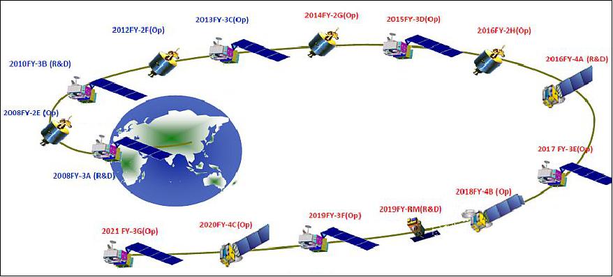
Spacecraft | Launch Date | Comment |
FY-2A | June 10, 1997 | Regarded as experimental S/C in GEO; FY-2A was retired in April 2000 |
FY-2B | June 26, 2000 | Regarded as experimental S/C in GEO; |
The second group has three satellites, including FY-2C, FY-2D and FY-2E. This group enjoys a noticeably enhanced performance. For example, the onboard scanning radiometer has five channels rather than the three channels on FY-2A and FY-2B, with enhanced major technical indicators. It also enjoys an improved onboard battery capacity that ensures the power supply to the onboard instruments around the spring and autumn equinox where moon shadow would affect solar power supply. | ||
FY-2C | Oct. 19, 2004 | Operational as of 2006; FY-2C is regarded as the first operational meteorological satellite mission (in GEO) of China |
FY-2D | Dec. 8, 2006 | FY-2D functions as backup to FY-2C, |
FY-2E | Dec. 23, 2008 | To replace operations of FY-2C |
The last group has FY-2F, FY-2G and FY-2H, with improved performance compared with the second group. This group of satellites is designed to bridge a consistent and stable transition from the first generation to the second generation, as China's first generation geostationary meteorological satellites fleet in orbit will cease to provide application services around 2015/2016. | ||
FY-2F | Jan. 13, 2012 |
|
FY-2G | Dec. 31, 2014 |
|
FY-2H | June 05, 2018 |
|
Background
The development of the FY-2 geosynchronous meteorological satellite series began in the 1980s (Ref. 2). The first satellite was ready for launch in 1994. However, while the satellite was being loaded with propellant in the process facilities at the Xichang Satellite Launch Center, it exploded killing one technician and injuring 31 others.
The explosion destroyed the satellite and it took three years to prepare a replacement after the redesign of the propellant tank system.
The first FY-2 satellite to reach orbit, FY-2A Fengyun-2A (24834 1997-029A), was eventually launched by the Long March-3 (Y11) launcher from the LC1 launch platform at Xichang on 10 June 1997.
This satellite was operational until April 1998 when it began to suffer from problems. The control of the satellite was regained on December 1998, but the capabilities of the satellite were very limited with only six images a day. The satellite was later moved to 86.6º East when meteorological operations ended.
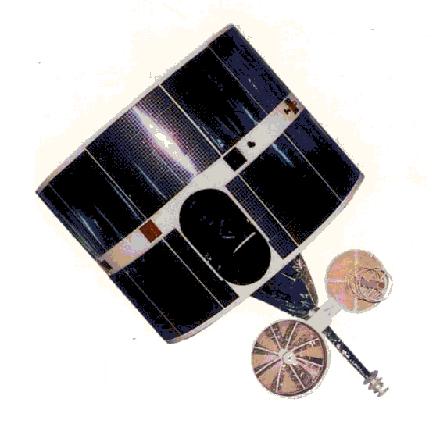
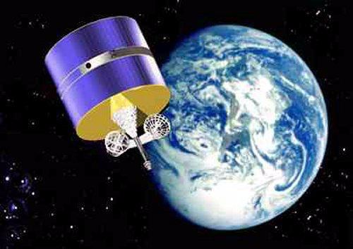
In general, the Fengyun-2 satellites are spin-stabilized satellites with a total mass of 1,369kg at launch (536kg dry mass).
Spacecraft
The FY-2 spacecraft are dual spin-stabilized at 100 rpm with a despun antenna platform (similar in design and operation to the GMS series of Japan). The FY-2 spacecraft bus is 2.1 m in diameter with a height of about 1.6 m (cylinder), S/C on-orbit mass = 593 kg. Power (280 W) is generated by surface-mounted solar cells. The observation objectives of the Asia-Pacific region are:
- Acquiring daylight visible cloud maps, day-and-night infrared cloud maps and water vapor distribution maps
- Data collection from meteorological, oceanic and hydrological observational platforms
- Broadcasting of stretched digital cloud maps, low resolution cloud maps and weather map information
- Obtaining cloud top and sea surface temperatures as well as the wind field distribution by data processing.
In 1994, the long-awaited FengYun-2 GEO meteorological spacecraft was to be launched and positioned at 105º E longitude. The first FY-2 satellite in the series, namely FY-2A, was undergoing final check-out on April 2, 1994, before being mated to its launch vehicle, when a fire and explosion erupted, destroying the vehicle. 3)
FY-2A (FengYun-2A)
A second identical satellite, also referred to as FY-2A, was built by the Shanghai Institute of Satellite Engineering and launched by a Long March 3 (CZ-3) booster from Xichang on June 10, 1997. The first imagery of S-VISSR was received on July 13, 1997. FY-2A data can be received by all international users.
On 8 April 1998, FY-2A ceased transmission of S-VISSR images, to resume for a few hours on 10 April, due to a problem with the S-band antenna on the spacecraft. CMA managed to regain Earth lock and ranging with the S-band antenna for 12 hours on 14 April 1998, but there were no regular S-VISSR retransmissions during the summer of 1998. However, CMA could still get raw image downlinks a few times per day, and they would make one full-earth picture on the ground each day, but not broadcast it. As of October 1998, CMA resumed a partial but regular communication service of six transmissions per day. The FY-2A spacecraft was finally retied in April 2000.
Orbit: Geosynchronous orbit at position: 105º eastern longitude.
Ground segment
The FY-2 program ground system consists of a CDAS (Command and Data Acquisition Station), a DPC (Data Processing Center), a SOCC (Satellite Operation Control Center), ranging stations (one primary station, three secondary stations including one in Australia), widely dispersed data collection platforms (DCP), MDUS (Medium-scale Data Utilization Stations) and SDUS (Small-scale Data Utilization Stations), as well as a ground communications system.
Sensor Complement
S-VISSR (Stretched - Visible and Infrared Spin-Scan Radiometer)
S-VISSR is an optomechanical system. Scanning modes: a) normal scanning; b) optional scanning; c) single line scanning. A picture frame (normal scanning) = 30 minutes, a scan (North-South) = 2500 steps.
Parameter | Visible | Infrared | Water vapor |
Spectral band (µm) | 0.55 - 1.05 | 10.5 - 12.5 | 6.2 - 7.6 |
No. of detectors/channels | 4 (+4 spare) | 1 (+1 spare) | 1 (+1 spare) |
Scan lines | 2500 x 4 | 2500 | 2500 |
Spatial resolution | 1.25 km x 1.25 km | 5 km x 5 km | 5 km x 5 km |
Detectors | Si photodiode | HgCdTe | HgCdTe |
Data quantization | 6 bit | 8 bit | 8 bit |
Noise performance | SNR=6.5 (albedo=2.5%) | NEDT=0.5-0.65 K | NEDT= 1 K |
Scan step increment | 140 µrad (N-S scanning) | ||
Temporal resolution | 30 minutes (frame time) | ||
The telescope collects radiation during each scan and focuses it on the detectors in the focal plane using primary and secondary mirrors. The Si photodiode detector array has four elements mounted normal to the scan direction, providing a 5 km wide instantaneous observation coverage on each scan line, matching the scan line width of the IR detectors with only one detector element. The HgCdTe detectors are cooled by radiation coolers to a temperature of 100 K. A complete scan of 20º x 20º, covering the full Earth disk, is obtained every 30 minutes by means of the S/C spin motion (100 rpm from E-W) and the step action (2500 steps from north to south) of the scan mirror.
The FY-2 ground segment (geostationary satellites) consists of the following facilities
1) CDAS (Command and Data Acquisition Station)
2) DPC (Data Processing Center)
3) SOCC (Satellite Operations and Control Center)
4) Ranging stations (one primary and three secondary stations, including one in Australia)
5) DCPs (Data Collection Platforms)
6) MDUS (Medium-scale Data Utilization Station) and SDUS (Small-scale Data Utilization Station) stations.
Channel | Frequency | Modulation | Power | Bandwidth |
S-VISSR | 1687.5 MHz | PCM/BPSK, NRZ-M | 57 dBm | 2 MHz |
LR-Wefax | 1691.0 MHz | AM/FM | 57 dBm | 260 kHz |
S-Fax | 1699.5 MHz | AM/FM | 46 dBm | 26 kHz |
FY-2 series RF communications
The FY-2 satellites broadcast their data to the ground, this includes S-VISSR, WEFAX and S-FAX data. S-VISSR data are received at MDUS, while WEFAX and S-Fax (domestic use only) data are retransmitted to SDUS stations only. The S-FAX link transmits processed satellite image data, other weather data and administrative information via S-band to domestic users in China.
Digital and cloud map transponder: Frequency: 1.7/2.0 GHz; EIRP (dBw) original cloud map and stretched cloud map: 57.5; EIRP (dBw) weather map broadcast: 46. The data rate of S-VISSR is 660 kbit/s, the modulation is: PCM/BPSK, NRZ-M, polarization: linear, bandwidth = 2 MHz. Since the signal characteristics of the S-VISSR instrument data are the same as those of the VISSR instrument of the Japanese GMS series (except the frequency), the user stations receiving GMS VISSR data are also capable of receiving S-VISSR data, simply by changing the antenna pointing and frequency of the receiver local oscillator.
DCS (Data Collection System) of the FY-2 Series
The DCS provides operational collection services for data collection platforms (DCPs) within its field of view. The overall system is composed of the following subsystems:
• The space segment: a DCS platform on the FY-2 satellite consisting of: a UHF/S-band transponder, a mechanically despun S-band antenna, and a UHF receive antenna. Data collection transponder:Frequency = 401/468 MHz; EIRP = 47.3 dBw; No. of channels: 133, 100 of these channels are for domestic use and 33 international channels. DCS offers a capability and a new digital S-band fax service (CCITT G3) for domestic distribution of charts and imagery.
• The deployed DCPs (Data Collection Platforms) in the ground segment. The regional DCPs are stationary DCPs installed on buoys, islands, rivers, mountains or ships.
• The ground-based NSMC (National Satellite Meteorological Center) which collects and processes the DCP data and distributes it via GTS to the user community.
FY-2B (FengYun-2B)
The second Chinese GEO satellite, FY-2B, was launched on June 26, 2000 from the Xichang launch center with the Long March 3 (LM-3) vehicle.
The FY-2B S/C is identical to the previous FY-2A satellite and carries the same payload (S-VISSR, and DCS). The S/C is spin-stabilized with a spin rate of 100 rpm. The on-orbit dry mass is 600 kg, the launch mass is 1250 kg. The S/C design life is 3 years.
The daytime visible image can be used to derive the reflectance of cloud top and the earth surface, the nighttime infrared image can observe the thermal radiance, while the water vapor image can estimate the water vapor amount in the atmosphere. The satellite also broadcasts low resolution WEFAX image and collects data from automatic data collection platforms. Free transmission of S-VISSR data and WEFAX imagery are open to all users within the FY-2B transmission coverage.
Orbit: Geosynchronous orbit at position: 105º eastern longitude.
Channel | FY-2, A, B | FY-2, C, D, E |
VIS (Visible) | 0.50 - 1.05 µm | 0.50 - 0.99 µm |
IR1 (Infrared 1) | 10.5 - 12.5 µm | 10.3 - 11.3 µm |
IR2 |
| 11.5 - 12.5 µm |
IR3 |
| 3.5 - 4.0 µm |
WV (Water Vapor) | 6.3 - 7.6 µm | 6.3 - 7.6 µm |
FY-2C (FengYun-2C)
FY-2C is a geostationary meteorological satellite of CMA (China Meteorological Administration) with the intent to replace the services of FY-2B. The FY-2C spacecraft uses dual-spin stabilization, electric power of 300 W is being provided. The S/C launch mass is 1380 kg, and the design life is 3-4 years.
While the FY-2A and -2B satellites were so-called experimental satellites in GEO, the FY-2C spacecraft is regarded as the first "operational" weather satellite in China - providing its services to a large user community.
The mission objectives of FY-2C are: 4) 5)
• Acquiring visible, infrared and water vapor cloud images
• Re-transmitting S-VISSR images and low resolution images
• Provision of data collection services
• Space environment monitoring
Like its predecessors, FY-2C is a spin-stabilized satellite. The following changes were implemented:
• The spin rate of FY-2C has been changed to 98 rpm (previously 100 rpm) to permit enough time for raw data transmission in a cycle (the transmission of a full disk image takes 25.5 minutes, rather than 25 minutes).
• The power supply of the spacecraft has been improved (from 17 Ah to 25 Ah) in support of a better eclipse management.
• The WEFAX function is being replaced by LRIT (Low Rate Information Transmission) for improved services to the user. The LRIT format is in agreement with the standard protocol recommended by CCSDS. The primary objective of the LRIT service is to deliver image data for nowcasting within a few minutes of the end of acquisition of each image
• The fax service of FY-2A, B is being discontinued on FY-2C
• FY-2C carries out two types of broadcast schedules:
- Regular schedule: provides 24 full disc images every day plus 4 images for deriving wind products
- Flood season schedule: transmits full disc images in the early half hour; for the late half hour, a certain number of sector scan images in northern hemisphere is expected to be transmitted in total size of 1400 scan lines, taking 15 minutes time to scan.
Launch
FY-2C was launched on Oct. 19, 2004 on a CZ-3A vehicle from the Xichang Launch Center, China.
RF communications: Broadcast of S-VISSR data at 660 kbit/s, and LRIT (Low Rate Information Transmission) data at 150 kbit/s.
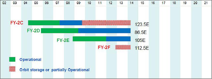
Orbit: Geosynchronous orbit at position: 123.5º eastern longitude.
Mission Status
• Dec. 26, 2014: CMA reports that the FY-2C satellite has been successfully deorbited (raising of orbit) in the period Dec. 10-13, 2014. CMA used the FY-2C services until Nov. 25, 2009. Thereafter, the spacecraft had been in backup status. The FY-2C spacecraft was on orbit for 10 years. 6) 7)
- After deorbiting, all instruments of the satellite were closed. The whole process and the results met the mitigation specifications of space debris and IADC requirements.
- Currently, there are three FY-2 geostationary meteorological satellites in-orbit (FY-2D, FY-2E and FY-2F).
• The FY-2C spacecraft and its payload are operating nominally in 2012.
- In fact, the following GEO spacecraft of CMA/NSMC are operating in 2012: FY-2C, FY-2D, FY-2E and FY-2F. 8)
• FY-2C (launch Oct. 19, 2004) is operating nominally as of 2006. FY-2C can be regarded as the first operational meteorological satellite mission (in GEO) of China.
• The broadcast service of S-VISSR data started on January 1, 2005. From June 1, 2005 onwards, FY-2C produces and distributes also its AMV (Atmospheric Motion Vector) data products.
Sensor Complement
S-VISSR (Stretched - Visible and Infrared Spin-Scan Radiometer)
The upgraded S-VISSR of FY-2C features 5 spectral bands (1 VIS, 4 IR). This measure improves the following instrument observation functions:
• The capability of detecting and calculating water vapor contents, to support semi-transparent ice cloud detecting, and to have a better accuracy of atmospheric absorption correction for better sea temperature estimation.
• Improved temperature resolution of the IR bands and SNR of the VIS band; support of split window application.
• The data quantization level of the IR bands has been increased from 256 (8 bit) to 1024 (10 bit).
Parameter / Spacecraft | FY-2A, B | FY-2C |
Spectral range (µm) | 0.5-1.05 | 0.55-0.99 |
FOV (µrad) | 40 | 35 |
Spatial resolution (km) | 1.44 | 1.25 |
Dynamic range | 0-95% | 0-0.98% |
SNR | 6.5 (2.5%) | 1.5 (0.5%) |
No of detectors | 4+4 (spare) | 4+4 (spare) |
Data quantization | 64 (6 bit) | 64 (6 bit) |
Calibration | Cold space images and solar image to realize in-orbit calibration | |
Parameter / Spacecraft | FY-2A, B | FY-2C | ||||
| IR | WV | IR1 | IR2 | IR3 (WV) | IR4 |
Spectral range (µm) | 10.5-12.5 | 6.3-7.6 | 10.3-11.3 | 11.5-12.5 | 6.3-7.6 | 3.5-4.0 |
FOV (µrad) | 160 | 160 | 140 | 140 | 140 | 140 |
Spatial resolution (km) | 5.76 | 5.76 | 5 | 5 | ||
Dynamic range | 180-330 K | 190-290 K | 180•330 K | 180-280 K | 180•330 K | |
Temperature resolution | 0.6 K | 1.0 K | 0.4-0.2 K | 0.4-0.2 K | 0.6-0.5 K | 0.5-0.3 K |
No of detectors | 1+1 | 1+1 | 1+1 | 1+1 | 1+1 | 1+1 |
Data quantization | 6 bit | 6 bit | 10 bit | 10 bit | 10 bit | 10 bit |
Calibration | Onboard blackbody calibration, once every 3 disks | The ground calibration accuracy is 1 K. Cool space and planet calibration is used for onboard calibration, once every 2 disks. | ||||
DCS (Data Collection System)
The DCS features a transponder that relays to ground the data collected in situ by the DCPs (Data Collection Platforms) in the ground segment. Applicable in LEO and GEO. The data collection frequency is in UHF (~401 MHz).
Operating modes:
• Random access to collect messages transmitted at fixed times (self-timed DCP) or in emergency (alert DCP)
• Message acquisition only after interrogation of the DCP
• Location of the DCP if mobile (only from LEO).
SEM (Space Environment Monitor)
FY-2 satellites are equipped with a particle detector and an X-ray detector to monitor the space environment where the satellites are working. They collect space environment data, including solar activities, and send them back to the ground application system for satellite projects planning, space environment studies, and space hazards warning (Ref. 8).
FY-2D (FengYun-2D)
The FY-2D spacecraft carries the same sensor complement as FY-2C.
Launch
A launch of FY-2D took place on Dec. 8, 2006 on a CZ-3A vehicle from the Xichang Launch Center, China.
Orbit: On the geostationary orbit, the operational configuration includes two satellites with FY-2C at 105ºE and FY-2D at 86.5ºE providing a back-up capability.
Mission Status
The FY-2D spacecraft is operational as of October 2017 at the location 123.5ºE (Ref. 10).
FY-2E (FengYun-2E)
The FY-2D spacecraft is identical to the FY-2C, carrying also the same sensor complement as FY-2C.
Launch
FY-2E was launched on Dec. 23, 2008 on a CZ-3A vehicle from the Xichang Launch Center, China.
Orbit: On the geostationary orbit, the operational configuration includes two satellites with FY-2C at 105ºE and FY-2D at 86.5ºE providing a back-up capability.
Mission Status
The FY-2E spacecraft is operational as of October 2017 at the location 86.5ºE. 10)
FY-2F (FengYun-2F)
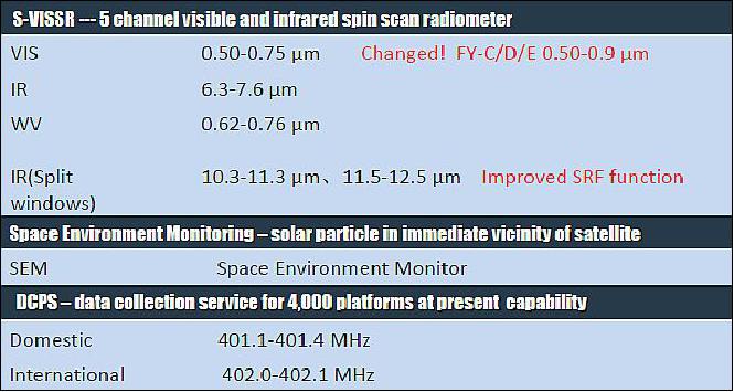
Like its predecessors, the FY-2F is dual spin-stabilized spacecraft at 100 rpm with a despun antenna platform. The spacecraft is cylindrical with a diameter of 2.1 m and a length of 4.5 m. FY-2F is carrying the same sensor complement as FY-2C - with the changes as listed in Figure 5.
Launch mass of FY-2F spacecraft = 1380 kg. After orbit raising from GTO into GEO, by means of an FG-36 apogee motor, the on-orbit mass of the spacecraft is 680 kg. The design life is 6 years. Onboard power of 300 W.
Launch
FY-2F (aka FengYun-2-07) was launched on January 13, 2012 (00:56 UTC) on a Long March 3A (CZ-3A) vehicle from LA3 (Launch Area 3) at the Xichang Satellite Launch Center.
Orbit: Geostationary orbit, altitude = 35,786 km, longitude of 112.5ºE.
Mission Status
The FY-2F spacecraft is operational as of October 2017 at the location 112.5ºE (Ref. 10).
FY-2G (FengYun-2G)
The FY-2G spacecraft has identical performance parameters as its predesessor carrying also the same sensor complement - with the changes as listed in Figure 5.
Launch
FY-2G (aka FengYun-2-7) was launched on December 31, 2014 (01:02:04 UTC) on a Long March 3A (CZ-3A) vehicle from LA3 (Launch Area 3) at the Xichang Satellite Launch Center. 11)
Orbit: Geostationary orbit, altitude = 35,786 km, longitude of 86.5ºE.
Mission status
• The FY-2G mission is operational as of October 2017 at the location 105ºE (Ref. 10).
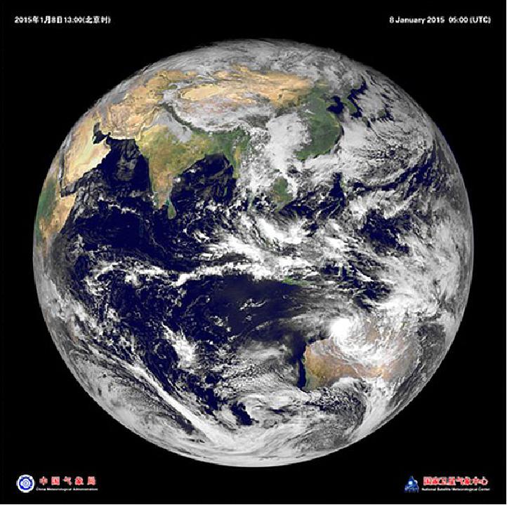
• On January 8, 2015, NSMC (National Satellite Meteorological Center) of CMA (China Meteorological Administration) successfully acquired the first satellite visible imagery of FY-2G. The imagery is quite clear and in focus. 12)
- Compared with the FY-2F satellite, the FY-2G further suppresses the stray light of satellite imagery and significantly improve the imagery quality. The first satellite visible imagery of FY-2G is the clearest imagery made by the series of FY satellites. It shows that the communication link between satellite and ground is opened up, the system is well-matched and the instruments of the satellite are working properly.
- Based on the technology of FY-2 F satellite, the FY-2G satellite has been improved from three aspects: reducing infrared stray radiation, uplifting observation frequency for the blackbody, and improving telemetry resolution of optical components. These improvements will advance the retrieval accuracy of FY-2G satellite quantitative products, and enhance the quantitative application of satellite data products.
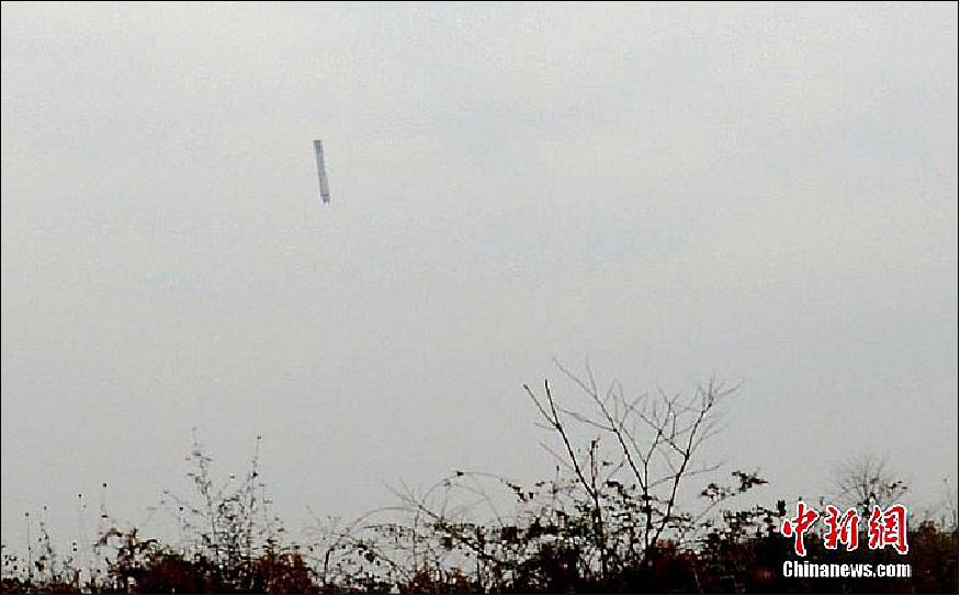
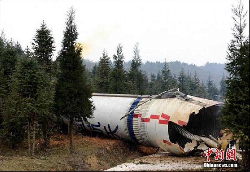
• January 5, 2015: CNS (China News Service) published online photos of a journalist who captured the moment the debris was falling across the sky in China's Guizhou province on Dec. 31, 2014. No injuries or damage to the local village was reported. The Long March 3A rocket debris stems from the successful launch of the FY-2G which occurred a few minutes earlier. 13)
FY-2H (FengYun-2H)
The FY-2H spacecraft has identical performance parameters as its predecessor carrying also the same sensor complement - with the changes as listed in Figure 5.
Launch
FY-2H (aka FengYun-2-8) was launched on 5 June 2018 (13:07 UTC) on a Long March 3A (CZ-3A) vehicle from LA3 (Launch Area 3) at the XSLC (Xichang Satellite Launch Center). Mass at launch: 1380 kg, dry mass = 680 kg, power = 300 W). 14)
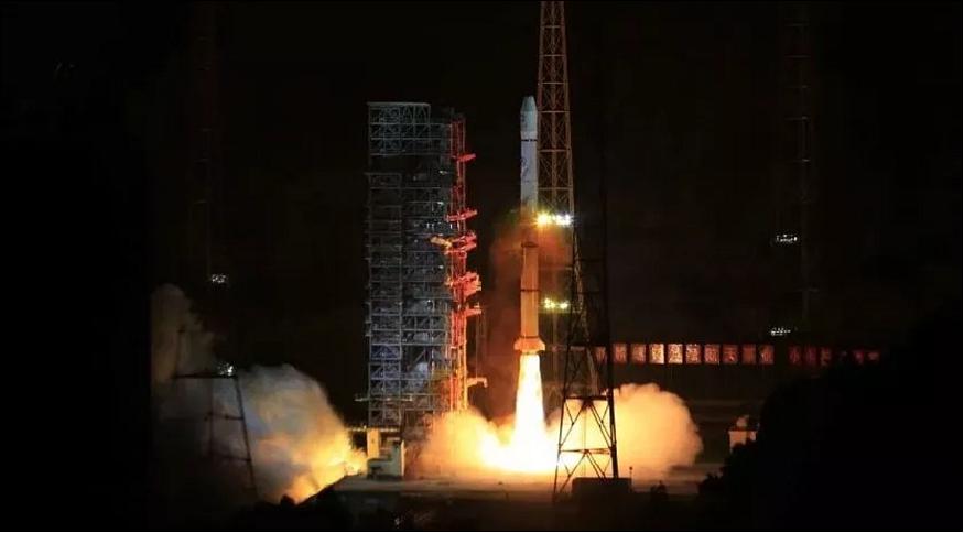
The China Aerospace Science and Technology Corporation (CASC) announced success of the launch just under an hour after liftoff.
Fengyun-2H is the eighth and final of the Fengyun-2 series of spin-stabilized weather satellites for geostationary orbit, development of which began in the 1980s under CASC.
Fengyun-2H is designed with a lifetime of at least four years and will be positioned at 79ºE, after on-orbit testing at 86.5 ºE. It will be operated by the National Satellite Meteorological Center (NSMC) of the China Meteorological Administration (CMA).
Orbit: Geostationary orbit, altitude = 35,786 km, longitude of 79ºE.
The satellite is equipped with a S-VISSR (Stretched Visible and Infrared Spin Scan Radiometer) for multi-purpose weather satellite imagery, a SEM (Space Environment Monitor), a SXM (Solar X-ray Monitor) and a DCS (Data Collection Service).
FengYun GEO Ground Segment
The FY geostationary ground system consists of the following elements: 15)
• CDAS (Command and Data Acquisition Station)
• DPC (Data Processing Center)
• SOCC (Satellite Operation Control Center)
• Ranging Stations (one primary station, three secondary stations including one in Australia)
• Widely dispersed DCPs (Data Collection Platforms)
• MDUS (Medium-scale Data Utilization Stations)
• SDUS (Small-scale Data Utilization Stations)
• Ground Communication System.
The tasks of FY-GEO ground system are as follows:
- Receive day and night cloud, water image data from FengYun geo-satellites
- Produce a variety of images and products after processing by DPC
- .Receive and distribute observation data collected by DCPS
- Broadcast observation data to users
- Extract the information of solar protons and other particles from telemetry data stream for space weather service
- Satellite mission control, and satellite status monitoring.
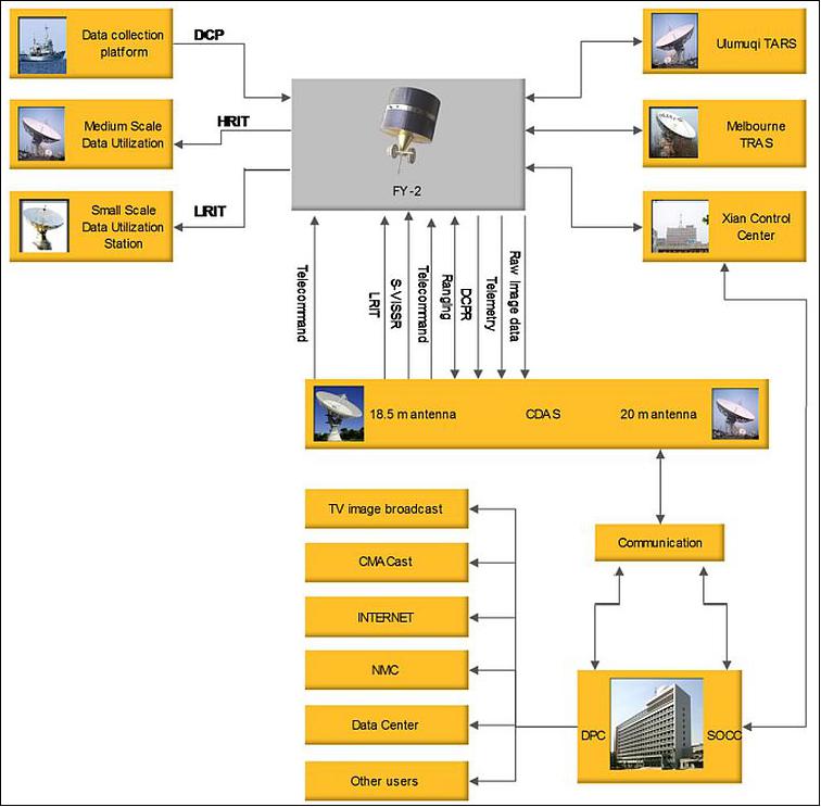
CDAS (Command and Data Acquisition Station):
CDAS is located in the western suburbs of Beijing (116º16'34"E, 40º03'03"N). The CDAS consists of antenna, receiver, transmitter, telemetry, command and synchronous data buffers (S/DB) etc. The main tasks of the CDAS are as follows:
1) Receiving raw data with bit rate of 14 Mbit/s by the antenna
2) Transmitting stretched VISSR data in HRIT format
3) Transmitting command signals to the FY-2 satellite
4) Receiving telemetry (including SEM) data
5) Transmitting and receiving ranging signals
6) Receiving DCP (Data Collection Platform) reports from platforms.
DCP (Data Processing Center)
The DPC is for satellite data processing, archiving and product distribution. It consists of main computers, communication controller local network, a series of large capacity disk and peripheral devices. The tasks for the Data Processing Center are:
1) Satellite Remote Sensing Data Processing: The raw image data received in realtime by CDAS is converted to the stretched image through S/DB in CDAS. Telemetry and trilateral ranging data received by CDAS is transmitted to DPC, where the satellite orbit and attitude are calculated and predicted. Image calibration and location calculation are completed to support the work of Satellite Control Center and remote sensing products processing. The SEM data are also processed in realtime; various kinds of remote sensing products are derived from S-VISSR image data.
2) The data processing of the DCP (Data Collection Platform)
3) The data processing of SEM
4) On-line and off-line archiving of the various kinds of remote sensing products.
SOCC (Satellite Operation Control Center)
SOCC is responsible for operational monitor and control of FY-GEO system. The major functions of SOCC are as follows:
1) Operational control and schedule: making operational schedule, issuing sending command to FY GEO-satellite, monitoring and scheduling ground application system
2) Telemetry data processing, image quality monitoring and analysis
3) Realtime data monitoring and displaying.
References
1) W. Zhang, C. Dong, J. Xu, J. Yang, "Current and Future Meteorological Satellite Program of China," CMA, Beijing, May 30, 2005, URL: http://cimss.ssec.wisc.edu/itwg/itsc
/itsc14/presentations/session9/9_2_zhang.pdf
2) Rui C. Barbosa, "Long March 3A launches Fengyun-2H," NASA Spaceflight.com, 5 June 2018, URL: https://www.nasaspaceflight.com/2018
/06/long-march-3a-launches-fengyun-2h/
3) A. Lawler, "Blast at Xichang Derails China's Weather Effort", Space News, May 2-8, 1994, p. 3
4) Report of the 31st Meeting of the Coordination Group for Meteorological Satellites (CGMS XXXI), Ascona, Switzerland, Nov. 10-13, 2003, PRC-WP-06 prepared by CMA, "Geostationary Meteorological Satellite FY-2C,"
5) J. Zhang, "Applications of FY-2C Meteorological Satellite in China," EUMETSAT Meteorological Satellite Conference, Dubrovnik, Croatia, Sept. 19-23,2005
6) Shi Long, "FY-2C satellite successfully deorbited," CMA, Dec. 26, 2014, URL: http://www.cma.gov.cn/en2014/news/
News/201412/t20141226_270619.html
7) "Disused satellite at 123.5ºE de-orbits successfully," NSMC, Dec. 31, 2014, URL: [web source no longer available]
8) "FY-2 Series Satellites," NSMC, URL: [web source no longer available]
9) Feng Lu, "CMA report on the current and future satellite systems," CGMS-42 (Coordination Group for Meteorological Satellites) plenary session, Guangzhou ,China, May 2014, URL: http://www.eumetsat.int/website/wcm/idc/idcplg?IdcService=GET_FILE
&RevisionSelectionMethod=LatestReleased
&Rendition=Web&dDocName=CWPT_1242
10) Jing Nie, "Current and future CMA MetSat systems," Presented to second WMO/ITU Seminar, 23-24 October 2017, URL: https://www.itu.int/en/ITU-R/study-groups/workshops
/RSG7-ITU-WMO-RSM-17/Documents/Current%20and%20future%
20Chinese%20Meteorological%20Satellite%20Networks.pdf
11) "FY-2G meteorological satellite successfully launched," NSMC, Dec. 31, 2014, URL: [web source no longer available]
12) "First satellite visible imagery of FY-2G successfully acquired," NSMC, Jan. 9, 2015, URL: http://www.cma.gov.cn/en2014/news/News/201501/t20150109_271693.html
13) Ken Kremer, "Amazing Imagery Captures Plummeting Chinese Rocket Seen by Villagers," Universe Today, January 5, 2015, URL: http://www.universetoday.com/117862/amazing-imagery
-captures-plummeting-chinese-rocket-seen-by-villagers/
14) Andrew Jones, "Long March 3A rocket launches Fengyun-2H meteorological satellite," Space News, 5 June 2018, URL: http://spacenews.com/long-march-3a-rocket
-launches-fengyun-2h-meteorological-satellite/
15) "Outline of GEO System - FengYun GEO Ground Application Facilities," NSMC, URL: [web source no longer available]