EROS-B (Earth Remote Observation System-B)
EO
Operational (extended)
ISI
The Earth Remote Observation System-B (EROS-B) is the second satellite in the EROS series, and provides high-resolution imagery used for emergency monitoring, illegal construction supervision, agricultural monitoring, oil and gas exploration and infrastructure monitoring.
Quick facts
Overview
| Mission type | EO |
| Agency | ISI |
| Mission status | Operational (extended) |
| Launch date | 25 Apr 2006 |
| CEOS EO Handbook | See EROS-B (Earth Remote Observation System-B) summary |
Summary
Mission Capabilities
EROS-B hosts a Panchromatic Imaging Camera-2 (PIC-2), developed by Electro Optical Industries, Israel, to obtain high-resolution panchromatic imagery.
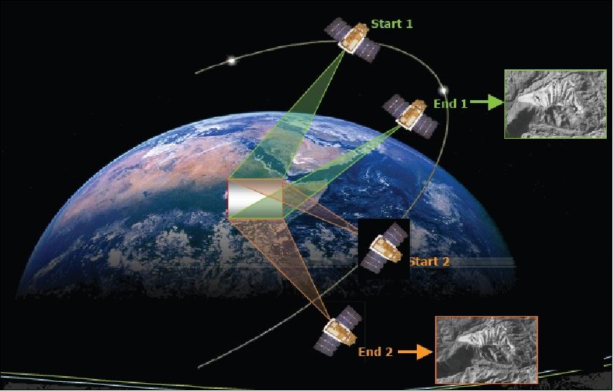
PIC-2 can be operated in either asynchronous or synchronous imaging mode. In synchronous mode, the spacecraft platform keeps a constant pointing angle toward the Earth's surface. In asynchronous mode, imaging by the detector array is performed in a "step-and-stare" fashion, which permits the generation of mosaics as well as the support of stereo imaging of targets of interest.
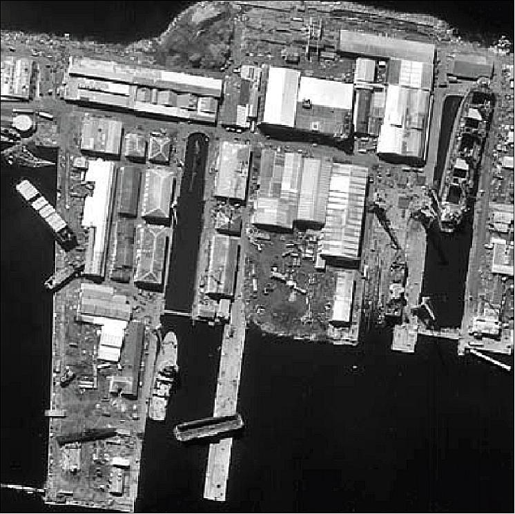
The detailed panchromatic images obtained by PIC-2 are used for emergency monitoring, illegal construction supervision, agricultural monitoring, oil and gas exploration and infrastructure monitoring.
Performance Specifications
The PIC-2 instrument hosted on EROS-B obtains panchromatic imagery across a 0.5 - 0.9 µm spectral range, with a spatial resolution of 0.7 m at ground sampling distance and a swath width of 7 km at nadir.
EROS-B follows a sun-synchronous circular orbit at a mean altitude of 500 km and an inclination of 97.4°. The orbits of EROS-A and EROS-B are phased in the same orbital plane to increase the revisit time of the EROS satellite constellation.
Space and Hardware Components
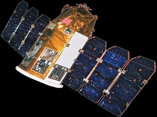
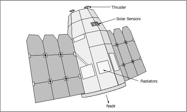
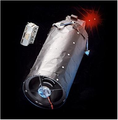
The EROS-B spacecraft structure is almost identical to EROS-A and based on the Ofeq satellite series design built by Israel Aircraft Industries Ltd. The 3-axis stabilised spacecraft bus has dimensions of 2.3 m by 4.0 m, with a mass of approximately 290 kg. EROS-B imagery is transmitted in X-band while the satellite is monitored and operated in S-band via a single ground control station located at Israel Aircraft Industries in Israel.
EROS-B (Earth Remote Observation Satellite-B)
Overview Spacecraft Launch Mission Status Sensor Complement References
EROS-B is a high-resolution commercial imaging minisatellite mission of ImageSat International N.V. headquartered in the Netherlands Antilles (Cayman Islands), with offices in Limassol, Cyprus, and in Tel Aviv, Israel. The overall objective is to provide high-resolution imagery to the customer base. 1) 2) 3)

Spacecraft
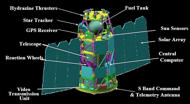
The EROS-B series S/C structure is identical to that of EROS-A, based on the Ofeq platform of Israel's Defense Ministry, and designed and built by Israel Aircraft Industries Ltd. (IAI/MBT). The deployed S/C structure is 2.3 m high and 4.0 m wide. The S/C is is 3-axis stabilized and the light/rigid design of the EROS satellite family allows for a great degree of platform agility. The spacecraft is very agile, a body-pointing capability of ±45º from nadir is provided in all directions, supporting the daily data acquisition plan. The S/C attitude is sensed and controlled as done with EROS-A. In addition, there is a star sensor for the B satellite series. The nominal S/C design life is six years.
The nominal spacecraft launch mass is ~290 kg; however, additional onboard fuel (up to 60 kg) is sufficient for spacecraft operations of up to 10 years. This action increased the spacecraft launch mass to about 350 kg.
Launch
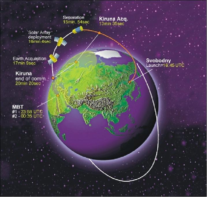
A launch of EROS-B took place on April 25, 2006, on a Start-1 launch vehicle from the Svobodny Cosmodrome in eastern Siberia (location at: 51.4º N, 128.3º E). 4) 5) 6)
Orbit: Sun-synchronous circular orbit, mean altitude = 500 km, inclination = 97.4º, local time of descending node (LTDN) at 14:00 hours.
- Note: The orbits of EROS-A and EROS-B are phased in the same orbital plane thereby increasing the revisit time of the constellation.
RF communications: Imagery is transmitted in X-band at a rate of 280 Mbit/s (downlink) to the ground receiving stations, using a 1.5 W transmitter and one of the two existing two-axis gimbaled directional antennas. The EROS satellites are monitored/operated in S-Band (TT&C) via a single ground control station (GCS), located at IAI/MBT in Israel (3 to 4 passes per day and per satellite are in station visibility). The S-band data rate is either 2.5 or 15 kbit/s selectable by the GCS.
ImageSat has a global network of ground segment infrastructure, for real-time image data acquisition. This network is comprised of the ImageSat Central Ground Control Station, a network of EROS-compatible Ground Receiving Stations on 5 continents and EROS-compatible Ground Control Stations based at exclusive customers' premises.
Mission Status
• June 27, 2016: Safety is the topmost concern for the upcoming Olympic and Paralympic Games, ensuring that millions of people from every nation will be kept safe is certainly a daunting task. To assist with this matter the Israeli satellite, EROS-B will capture high-resolution images of up to 50 cm in an area of 450 km, thus enabling the identification of objects, people, cars, and goods. 7)
- The announcement was made last week by Brazilian Defense Minister Raul Jungmann, who said the satellite will allow very detailed inspections of the city during the sporting events, reported the G1 news portal on June 24, 2016. The Eros-B satellite will be used on an experimental basis for six months as a security complement and, in the future, will support border surveillance, added the minister.
• EROS-B is operating nominally in the summer of 2015 (now in its 10th year on orbit).
• EROS-B is operating nominally in 2014.
Parameter | EROS-A | EROS-B | EROS-C |
Sun-synchronous orbit | ~530 km | ~520 km | ~520 km |
Spectral bands | Panchromatic | Panchromatic |
|
Swath width | 15 km | 7 km | 12 km |
Vector image up to | 150 km | 480 km | 600 km |
Spatial resolution | 2.0 m | 70 cm | 50 cm |
Launch/life expectancy | 2000-2015 | 2006-2022 | 2016-2026 |
• The EROS-B spacecraft and its payload are operating nominally in 2012. The EROS-B satellite ensures operational delivery of imagery data in different imaging modes (basic image, vector image and continuous image), as well as stereo and triplet imaging.
- The main applications of detailed EROS-B images are:
- emergency monitoring,
- illegal construction supervision,
- agricultural monitoring,
- oil and gas exploration,
- infrastructure monitoring.
• EROS-B is operating nominally in 2010.
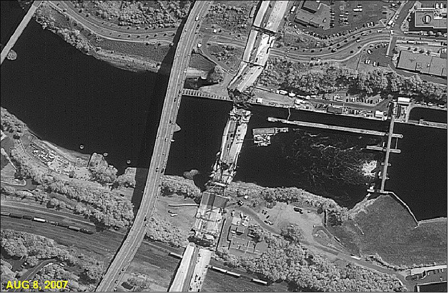
Legend to Figure 6: The I-35W Mississippi River Bridge was an eight-lane, steel truss arch bridge that carried Interstate 35W across the Mississippi River in Minneapolis, Minnesota, United States. During the evening rush hour on August 1, 2007, it suddenly collapsed, killing 13 people and injuring 145. The bridge was Minnesota's fifth busiest, carrying 140,000 vehicles daily. A design flaw was cited as the likely cause of the collapse and asserted that additional weight on the bridge at the time of the collapse contributed to the catastrophic failure.
• The satellite became fully operational on April 30, 2006, shortly after transmitting its first high-quality pictures back to Earth.
Sensor Complement
PIC-2
PIC-2 (Panchromatic Imaging Camera-2), was designed and developed by ElOp (Electro Optical Industries) of Rehovot, Israel, a subsidiary of Elbit Systems Ltd.
The EROS-B series imager instrument features CCD pushbroom technology in combination with a TDI (Time Delay Integration) scheme in its focal plane, a cumulative expose concept of each ground image line by a CCD detector array, to improve the SNR value (an important issue for high-resolution imaging). The instrument uses also a Cassegrain telescope with an aperture of 50 cm in diameter and a focal length of 5 m (folded optics). FOV = 1.5º. The PIC-2 instrument is rigidly mounted to the S/C structure looking into the nadir direction, thus permitting a body-pointing observation scheme.
Note: The PIC-2 instrument is also referred to as Neptune (High-Resolution Remote Sensing Camera) by ElOp.
The CCD pushbroom detector array provides 10,000 pixels per line and a total of 96 lines for selectable TDI observation support. Pushbroom scanning is provided for panchromatic imagery only in the spectral range of 0.5 - 0.9 μm. The ground sampling distance (GSD) is 0.70 m, the swath width is 7 km at nadir. The data is quantized at 10 bits/sample.
The imager instrument of the EROS-B spacecraft can be operated in either asynchronous or synchronous imaging mode. In synchronous mode, the S/C platform keeps a constant pointing angle toward the Earth's surface. In asynchronous mode, imaging by the detector array is performed in a "step-and-stare" fashion, i.e., by slewing the S/C platform in the along-track direction (this permits in particular the generation of mosaics as well as the support of stereo imaging of targets of interest). 11) 12)
Parameter | EROS-A | EROS-B |
Circular sun-synchronous orbit | ~530 km | ~ 520 km |
GSD (Ground Sampling Distance) | 1.9 m standard | 0.70 m panchromatic |
Swath width | 14 km | 7 km |
Scanning scheme | Asynchronous pushbroom | Asynchronous pushbroom or |
Spectral range of imagery | 0.5-0.9 µm | 0.5-0.9 µm |
Data quantization | 11 bit | 10 bit |
Downlink rate of imagery | 70 Mbit/s | 280 Mbit/s |
LTDN (Local Time on Descending Node) | 10:00 hours | 14:00 hours |
Launch - life expectancy (Ref. 2) | 2000 -2012 | 2006-2018 |
References
1) http://www.imagesatintl.com/
2) R. Hellermann, "The Commercial Market and the Operational experience," EOBN 2008 (Earth Observation Business Network), May 13-14, 2008, Richmond, BC, Canada
3) Rani Hellermann, "EROS B –Operational Experience, Second year of operation2008," JACIE Civil Commercial Imagery Evaluation Workshop, Fairfax, VA, USA, March 25-27, 2008, URL: http://calval.cr.usgs.gov/JACIE_files/JACIE08/2008_JACIE_DVD/Wednesday-PM/Hellerman_ImageSat.pdf
4) S. Clark, "New Israeli imaging spacecraft deployed in orbit," April 25, 2006, URL: http://www.spaceflightnow.com/news/n0604/25erosb/
5) "IAI's EROS B Commercial Satellite Sucessfully Launched from the Cosmodrome in Svobodny, Siberia in Russia," April 26, 2006, IAI, URL: http://www.iai.co.il/34322-36899-en/default.aspx?PageNum=6
6) Fred Ortenberg, "Israel in Space - Twenty Years of Exploration (1988-2008)," book, 2009, printed at Technion Press, Haifa, Israel, ISBN: 987-965-555-457-1
7) "Israel's EROS-B Satellite Rustles Up High Res Images For Rio Olympics," Satnews Daily, June 27, 2016, URL: http://www.satnews.com/story.php?number=523189582
8) ImageSat International, "Where are we now ???," Proceedings of the 51st Session of Scientific & Technical Subcommittee of UNCOPUOS, Vienna, Austria, Feb. 11-22, 2014, URL: http://www.unoosa.org/pdf/pres/stsc2014/tech-58E.pdf
9) http://www.moital.gov.il/CmsTamat/Rsrc/ICA/Industrial_cooperation_in_israel-2011-2012/pdf/Rashpat_181.pdf
10) https://web.archive.org/web/20101005222813/http://www.el-op.com/category/Commercial_programs
11) Gabi Lubosvski, "EROS B Orthorectification," MARS PAC Annual Conference, Madrid, Spain, Nov. 12-14, 2007, URL: http://mars.jrc.ec.europa.eu/mars/content/download/912/5731/file/3_T5b_Lubovski-EROS_B_orthophoto_IIT.pdf
12) Gabi Lubowski, "EROS B accuracy report," Aug. 4, 2008, URL: [web source no longer available]
The information compiled and edited in this article was provided by Herbert J. Kramer from his documentation of: "Observation of the Earth and Its Environment: Survey of Missions and Sensors" (Springer Verlag) as well as many other sources after the publication of the 4th edition in 2002. - Comments and corrections to this article are always welcome for further updates (eoportal@symbios.space).
Overview Spacecraft Launch Mission Status Sensor Complement References Back to top