CIMR (Copernicus Imaging Microwave Radiometer)
EO
ESA
Ocean
Approved
The Coprpencius Imaging Microwave Radiometer (CIMR) is a high priority candidate satellite mission, within the European Commission's (COM) Copernicus Expansion program. EC recently outlined new objectives pertaining to improved spatial and temporal coverage of sea ice and Arctic environment, in order to aid Arctic user communities.
Quick facts
Overview
| Mission type | EO |
| Agency | ESA, COM |
| Mission status | Approved |
| Measurement domain | Ocean, Snow & Ice |
| Measurement category | Surface temperature (ocean), Sea ice cover, edge and thickness, Ocean Salinity |
| Measurement detailed | Sea surface temperature, Sea-ice cover, Sea-ice thickness, Sea-ice type, Sea-ice Concentration, Sea Surface salinity |
| Instruments | Imaging Microwave Radiometer |
| Instrument type | Imaging multi-spectral radiometers (passive microwave) |
| CEOS EO Handbook | See CIMR (Copernicus Imaging Microwave Radiometer) summary |
Summary
Mission Capabilities
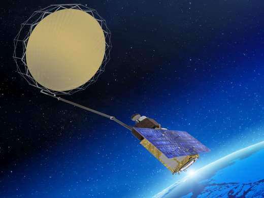
CIMR satellites will contain conically scanning microwave radiometer imagers, able to photograph ice and sea covered regions. In order to maintain a high swath throughout orbital transit, the instrument will rotate continuously about a local vertical axis. There are three main parameters which will be sought by CIMR, the Sea Surface Temperature (SST), the Sea-Surface Salinity (SSS) and the Sea Ice Concentration (SIC). Together, they will allow European researchers to improve their understanding of changing arctic conditions and how we can support people most affected in those regions.
Performance Specifications
CIMR’s onboard radiometer imager will operate across five spectral bands, corresponding to frequencies of 1.4, 6.9, 10.65, 18.7, and 36.5 GHz. Each target parameter will be imaged at a different resolution. The SST will be recorded with a spatial resolution of 15 km, with a sub-daily temporal sampling period. SIC will be more precisely recorded with a resolution of 5 km and also a sub-daily observation period. SSS will also be observed at a spatial resolution of 5 km, but with sampling only occurring, once per month.
CIMR is expected to follow quasi-polar orbit, tracing a near circular, sun-synchronous trajectory.
Space and Hardware Components
The CIMR satellite buses will be of previous Copernicus mission heritage, with the prime manufacturer remaining Thales Alenia Space. CIMR will be designed with a nominal lifetime of 7 years, producing sub-daily Arctic and Antarctic coverage. Current expectations limit the number of satellites in the mission to three, allowing for continuous day-and-night monitoring, while flying in convoy with MITOP 5G satellite B.
CIMR (Copernicus Imaging Microwave Radiometer) Mission
October 2018: Climate change resulting in ocean warming, sea level rise, and sea ice melting has consequences for the global economy, navigation, and security. The CIMR (Copernicus Imaging Microwave Radiometer) mission is a high-priority candidate satellite mission within the European Copernicus Expansion program.
It is designed to observe the ocean and sea ice and more particularly the Arctic environment. Sea surface temperature (SST), ocean wind speed, sea surface salinity (SSS), and sea ice concentration (SIC) are fundamental variables for understanding, monitoring, and predicting the state of the ocean and sea ice. Here we analyze the performances of this new satellite mission in terms of precision and spatial resolution on the sea surface temperature, sea surface salinity, and sea ice concentration and compare it with current missions. CIMR will provide sea surface temperature, sea surface salinity, and sea ice concentration with a spatial resolution of 15, 55, and 5 km and a precision of 0.2 K, 0.3 psu (practical salinity unit), and 5%, respectively. This satellite mission is currently in the preparatory phase. 1) 2)
On 27 April 2016, the European Commission and the High Representative of the Union for Foreign Affairs and Security Policy issued to the European Parliament and the Council, a joint communication that proposed 'An integrated Europe Union policy for the Arctic.' The Arctic's fragile environment is also a direct and key indicator of climate change, which requires specific mitigation and adaptation actions, as agreed with the global agreement reached during the United Nations Climate Change Conference, COP-21 (Conference of the Parties) held in Paris in December 2015.
The integrated EU Arctic policy has identified and is addressing three priority areas:
1) Climate Change and Safeguarding the Arctic Environment (livelihoods of indigenous peoples and Arctic environment).
2) Sustainable Development in and around the Arctic (exploitation of natural resources, e.g., fish, minerals, oil, and gas), Blue economy and safe and reliable navigation (e.g., the Arctic Northern Sea Route).
3) International Cooperation on Arctic Issues (scientific research, EU and bilateral cooperation projects, fisheries management/ecosystems protection, and commercial fishing).
Continuously monitoring the vast and harsh Arctic environment with Earth observation, navigation, and communication satellites is considered essential. The European Commission has expressed user needs that recommends, as a first priority, an Imaging Microwave Radiometry Mission to address the Integrated EU Arctic Policy through the provision of the operational ocean and sea-ice products with high spatial resolution, radiometric fidelity, and at least daily revisit in Polar regions. The Copernicus Imaging Microwave Radiometer (CIMR) mission is one of six High Priority Candidate Missions within the Copernicus Expansion program focused on new missions that have been identified by the European Commission as priorities for implementation in the coming years to provide additional capabilities in support of high priority user needs. The CIMR mission is currently in a phase A/B1 study.
CIMR is a conically scanning microwave radiometer imager that includes channels at 1.4, 6.9, 10.65, 18.7, and 36.5 GHz, in a Sun-synchronous polar orbit, to provide SST, ocean wind speed, SSS, and SIC with an increased accuracy and/or spatial resolution.
Development Status
• November 11, 2021: The Copernicus Imaging Microwave Radiometer (CIMR) satellite instrument is currently being implemented to observe the Polar Regions. It will measure different variables, including the temperature and salinity of the ocean surface, and the sea ice extension in the polar ice caps. To help design the instrument, the first instrument concept has been computer simulated. Together with simulations of the radiation emitted by the oceans, it allows the reproduction of what the instrument antennas will measure. This is followed by further computations that apply mathematical algorithms to the simulated measurements to estimate the values of the ocean and ice parameters of interest. Studying these simulated measurements is then used to see whether the CIMR instrument concept is suitable to achieve the mission goals, and how much better CIMR will measure compared with existing instruments already observing similar variables. Although more work is required to keep refining the instrument and its computer simulations, this study shows that CIMR can achieve its mission goals, measuring more accurately and with better spatial resolution than previous instruments, and greatly contributing to monitoring the rapid changes expected to take place in the Polar regions in the years to come. 3)
- The Copernicus Imaging Microwave Radiometer (CIMR) is a satellite system developed as part of the European Union Copernicus program expansion activities. CIMR is designed to monitor the rapid Earth system changes taking place in the Arctic in response to the Integrated European Policy for the Arctic. Prioritized user needs to be expressed by the European Commission Polar Expert Group.
- The aim of the mission is to provide high-spatial resolution microwave imaging radiometry measurements and derived products with global coverage and sub-daily revisit in the polar regions and adjacent seas to address Copernicus user needs.
Its main challenges are:
(1) to provide high spatial resolution 5 km Ka/Ku band measurements of sea ice parameters that provide an enhanced capability compared to 89 GHz solutions that are challenged by atmospheric effects;
(2) to provide high spatial resolution (15 km) C/X band measurements of global coverage sea surface temperature with quasi-all-weather capability and rapid (1–2 days) revisit, and;
(3) to maintain an L-band measurement capability to continue the legacy of sea surface salinity and soil moisture parameters from previous L-band missions.
- At the heart of the CIMR mission design is the need to measure fundamental quantities associated with large-scale ocean-cryosphere-atmosphere processes in the Arctic. Sea ice is part of the oceanographic "system" and the physics of eutectoid changes and the thermodynamically driven state of seawater is at the heart of the system.
Level-2 products include:
- Sea Ice Concentration (SIC),
- Sea Surface Temperature (SST),
- Sea Surface Salinity (SSS), Sea Ice Drift (SID),
- Sea Ice Thickness (SIT),
- Snow Depth on sea ice (SND),
- Sea Ice Surface Temperature (SIST).
As part of the mission design, which includes contiguous global coverage, CIMR will also have the capability to deliver a variety of additional parameters including:
- ice type,
- terrestrial snow extent,
- ice surface temperature,
- wind speed over the ocean,
- soil moisture,
- vegetation indices.
Data products are to be operationally available within 3 hr of sensing at the user point of pickup, with a capability to provide specific products within 1 hr of sensing in support of Arctic navigation safety.
- The CIMR instrument concept is based around a conically scanning multi-frequency microwave radiometer with a 55° incidence angle with the Earth's surface. Its design partly inherits from previous studies conducted at ESA for the Multifrequency Imaging Microwave Radiometer (MIMR). CIMR measurements will be made using a forward scan arc followed ~260 s later by a second measurement of the same location using a backward scan arc. Channels in bands L, C, X, Ku, and Ka, centred at 1.414, 6.925, 10.65, 18.7, and 36.5 GHz, respectively, are included in the mission design.
The measurements will be acquired in vertical (V) and horizontal (H) polarizations, with onboard the spacecraft and on-ground strategies put in place to mitigate Radio Frequency Interference (RFI) contamination. Modified Stokes parameters will be computed onboard the spacecraft. The spatial resolution of the real-aperture antenna for the C/X-band channel is at least 15 km, 5 and 4 km, and for the Ku and Ka-band channels, respectively. The L-band channel will have a real-aperture resolution of at least 60 km, fundamentally limited by the size of the reflector and the focus of the L-band feed.
However, all channels will be oversampled along and across-track by 20% allowing gridded products to be generated at better spatial resolutions. Channel Noise Equivalent Delta Temperature (NEΔT) is 0.2–0.7 K with total standard uncertainty at processing level L1B (instrument data processed to sensor units) better than 0.5 K (L, C, X), 0.6 K (Ku), and 0.7 K (Ka).
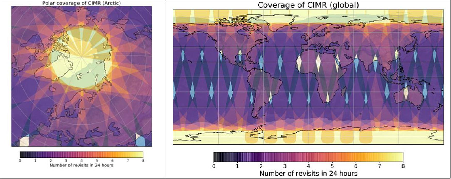
- CIMR will be flying in a dawn-dusk orbit deploying a wide-swath (>1,900 km), which will result in a 95% global coverage every day, better than daily coverage poleward of 55°N and 55°S, and no gap in coverage at the poles themselves. It is expected to operate in synergy with the European Organisation for the Exploitation of Meteorological Satellites (EUMETSAT) MetOp-SG(B) mission so that collocated and contemporaneous measurements between CIMR and MetOp-SG(B) Microwave Imaging Radiometer (MWI), Ice Cloud Imager (ICI), and Scatterometer (SCA) measurements can be made available within ±10 min in the polar regions.
- Measuring SIC and SST are the two first mission objectives, and therefore critical to deriving the mission requirements. The impact of the CIMR channel selection for SST retrievals is discussed in Nielsen-Englyst et al. (2021), and sensitivity analysis of CIMR observations over the Arctic Ocean is presented in Kilic et al. (2021). The third main objective is to assure continuity of the L-band, and, to illustrate the value of having the 1.4 GHz channel on board, the Sea Surface Salinity (SSS) retrieval performance is also studied. The main mission requirements for the measurements of SIC, SST, and SSS are summarized in Table 1.
Variable | Spatial resolution | Uncertainty a | Temporal sampling |
Sea Ice Concentration (SIC) | 5 km | <5% | Sub-daily |
Sea Surface Temperature (SST) | 15 km | <0.3 K | Sub-daily |
Sea Surface Salinity (SSS) | 5 km | <0.3 pss b | Monthly |
a: The value for SST is calculated for a theoretical retrieval as the mode value of daily global ocean average discrepancies assuming no uncertainty in the validation dataset, while for SIC and SSS it is a standard retrieval uncertainty.
b: Practical Salinity Scale 1978 (PSS-78) are used, following UNESCO guidelines (UNESCO, 1985). Although salinity measured using PSS-78 does not have units, the suffix "pss" is sometimes used in the text and figures to distinguish the values of salinity, rates, and variance.
• November 13, 2020: Today, ESA signed contracts with Thales Alenia Space in France and Italy, and Airbus in Spain to build three of the new high-priority Copernicus satellite missions: CHIME, CIMR and LSTM, respectively. Each mission is set to help address different major environmental challenges such as sustainable agriculture management, food security, and the monitoring of polar ice supporting the EU Integrated Policy for the Arctic, and all will be used to understand climate change. 4)
- ESA signed the contract for the development of the CIMR (Copernicus Imaging Microwave Radiometer) mission with Thales Alenia Space (TAS) Italy in the presence of the Under Secretary of the Council of Ministers of Italy, Riccardo Fraccaro. The contract is worth €495 million.
- Carrying a novel ‘conically-scanning' multi-frequency microwave radiometer, the mission will measure sea-surface temperature, sea-ice concentration and sea-surface salinity. It will also observe a wide range of other sea-ice parameters such as sea-ice thickness and sea-ice drift. CIMR is being developed in response to high-priority requirements from key Arctic user communities and will support the EU Integrated Policy for the Arctic. 5)
- Thales Alenia Space will serve as mission prime with main partners OHB Italia for the instrument and HPS (High-Performance Space Structure System GmbH) for the Antenna Reflector. This mission is dedicated to provide observations of Sea-Surface Temperature (SST), Sea-Ice Concentration (SIC) and Sea-Surface Salinity (SSS). Uniquely, it would also observe a wide range of other sea-ice parameters such as Sea Ice Thickness (SIT), Sea Ice Drift (SID), Ice Type/Stage, Snow Depth on Sea Ice or Ice Surface Temperature (IST). CIMR responds to high-priority requirements from key Arctic user communities and will improve the continuity of missions monitoring the Polar Regions, notably in terms of spatial resolution (~5 km) temporal resolution (sub-daily) and geophysical accuracy. CIMR measurement performances are at a worldwide state of art.
- The CIMR system consists of up to 3 Satellites dedicated to day-and-night monitoring of land, ice and oceans flying in loose convoy with METOP SG satellite B. CIMR orbit is quasi-polar, near circular and sun-synchronous. In order to acquire measurements on a wide swath, the instrument rotates continuously about an axis parallel to the local spacecraft vertical. The antenna system views the Earth's scene with a nearly constant incidence angle of about 55.5º.
- The CIMR satellites embark each a wide-swath conically-scanning multi-frequency microwave radiometer provided by OHB Italia and operating from L to ka band enabling radiometric measurements with unprecedented levels of accuracy. CIMR will be designed for a 7 years nominal lifetime with a sub-daily Arctic and Antarctic area coverage, it will be compatible with Vega-C and Ariane 6-2 launchers and will be fitted by a controlled reentry system.
- This program will take advantage of Thales Alenia Space's proven heritage in Copernicus missions, and Earth observation satellites as well as the OHB Italia experience on rotating microwave imager, the platform is based on the new Thales Alenia Space Multi-Mission Platform product line (MILA), and the Large Deployable Reflector (LDRS) will be provided by the German company HPS.
References
1) Lise Kilic, Catherine Prigent, Filipe Aires, Jacqueline Boutin, Georg Heygster, Rasmus T. Tonboe, Hervé Roquet, Carlos Jimenez, Craig Donlon, "Expected Performances of the Copernicus Imaging Microwave Radiometer (CIMR) for an All‐Weather and High Spatial Resolution Estimation of Ocean and Sea Ice Parameters," JGR (Journal of Geophysical Research) Oceans, Vol. 123, pp: 7564–7580, Published online: 29 October 2018, https://doi.org/10.1029/2018JC014408, URL: https://agupubs.onlinelibrary.wiley.com/doi/epdf/10.1029/2018JC014408
2) "Copernicus Imaging Microwave Radiometer (CIMR)Mission Requirements Document," ESA, 6 October 2020, URL: https://esamultimedia.esa.int/docs/EarthObservation/CIMR-MRD-v4.0-20201006_Issued.pdf
3) Carlos Jiménez, Joseph Tenerelli, Catherine Prigent, Lise Kilic, Thomas Lavergne, Sotirios Skarpalezos, Jacob L. Høyer, Nicolas Reul, Craig Donlon, "Ocean and Sea Ice Retrievals From an End-To-End Simulation of the Copernicus Imaging Microwave Radiometer (CIMR) 1.4–36.5 GHz Measurements," JGR Oceans, Volume126, Issue12, December 2021, e2021JC017610, First published: 11 November 2021, https://doi.org/10.1029/2021JC017610, URL: https://agupubs.onlinelibrary.wiley.com/doi/epdf/10.1029/2021JC017610
4) Contracts signed for three high-priority environmental missions," ESA Applications, 13 November 2020, URL: https://www.esa.int/Applications/Observing_the_Earth/Copernicus
/Contracts_signed_for_three_high-priority_environmental_missions
5) "Thales Alenia Space to build Copernicus CIMR satellites," TAS Press Release, 13 November 2020, URL: https://www.thalesgroup.com/en/worldwide/space/
press-release/thales-alenia-space-build-copernicus-cimr-satellites
The information compiled and edited in this article was provided by Herbert J. Kramer from his documentation of: "Observation of the Earth and Its Environment: Survey of Missions and Sensors" (Springer Verlag) as well as many other sources after the publication of the 4th edition in 2002.