CICERO (Community Initiative for Continuing Earth Radio Occultation)
EO
Operational (extended)
GeoOptics
CICERO satellites perform GNSS-RO of Earth's atmosphere and surface remote sensing by GNSS reflection and obtain data for weather forecasting, climate research, and space weather monitoring.
Quick facts
Overview
| Mission type | EO |
| Agency | GeoOptics |
| Mission status | Operational (extended) |
| Launch date | 23 Jun 2017 |
| CEOS EO Handbook | See CICERO (Community Initiative for Continuing Earth Radio Occultation) summary |
Summary
Mission Capabilities
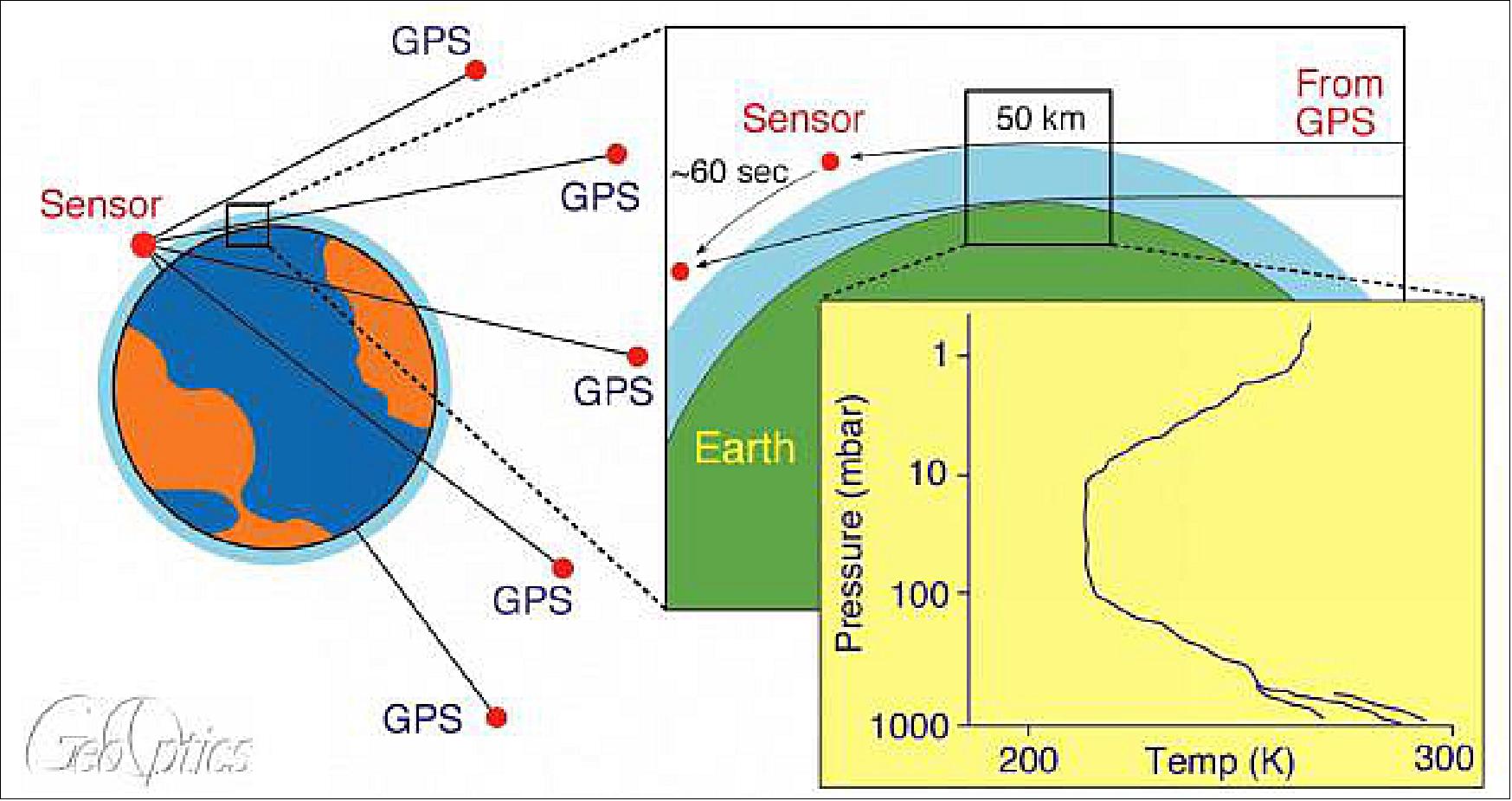
CICERO satellites host CION instruments (CICERO Instrument for GNSS-RO) which perform GNSS-RO by sensing radio signals broadcast by GNSS satellites (GPS and Galileo) and measuring the phase delay due to refraction during occultation.
Second-generation CICERO-2 satellites (two launched in 2022) carry an improved CION instrument, CION-2, which measures reflected signals from the sea surface and has a polarimetric capability, in addition to GNSS-RO. CION and CION-2 data produce high-accuracy profiles of atmospheric pressure, temperature, and moisture; 3D maps of the electron distribution in the ionosphere; and information on ocean and ice properties.
Performance Specifications
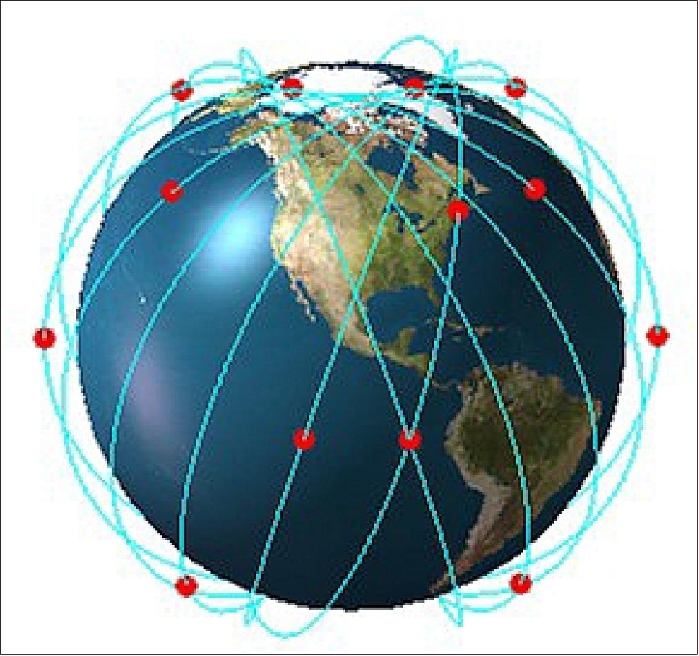
CION and CION-2 perform limb scanning from 500 km to close-to-surface by time sampling. The resolution of CION and CION-2 measurements is approximately 300 km horizontal and 0.5 km vertical. Based on calculations from three CICERO satellites carrying CION instruments, they can take about 1000 soundings daily, with an average spacing of 710 km and global coverage (300 km spacing) in two weeks
The altitudes and orbits of satellites in the CICERO cluster are optimised to maximise the global distribution of occultation events. CICERO satellites follow a sun-synchronous orbit with orbit heights ranging from 500 to 700 km, and various orbit inclinations depending on the launch of opportunity.
Space and Hardware Components
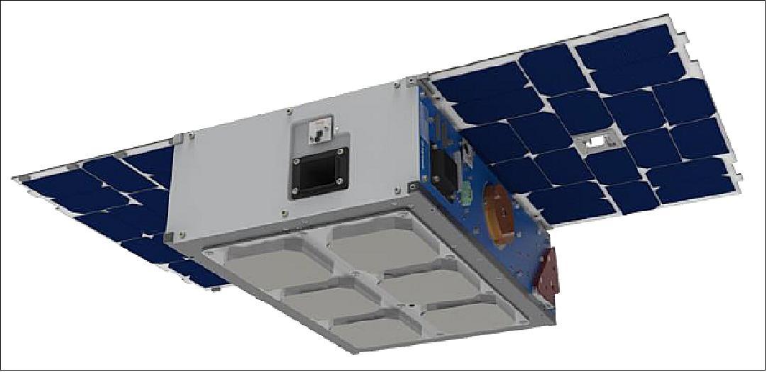
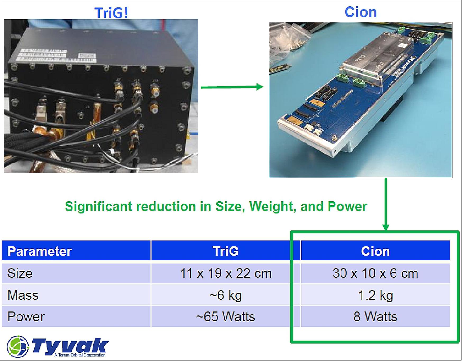
Originally GeoOptics planned to use the TriG GNSS-RO payload, developed for the FORMOSAT 7/COSMIC-2 mission and created a 115 kg CICERO microsatellite together with the Laboratory for Atmospheric and Space Physics (University of Colorado) to host this instrument. However, the development of CION, a miniaturisation of the GNSS-RO payload (from 6 kg to 1.5 kg), allowed for a change in satellite design to a much smaller 6U CubeSat version built by Tyvak Nanosatellite Systems.
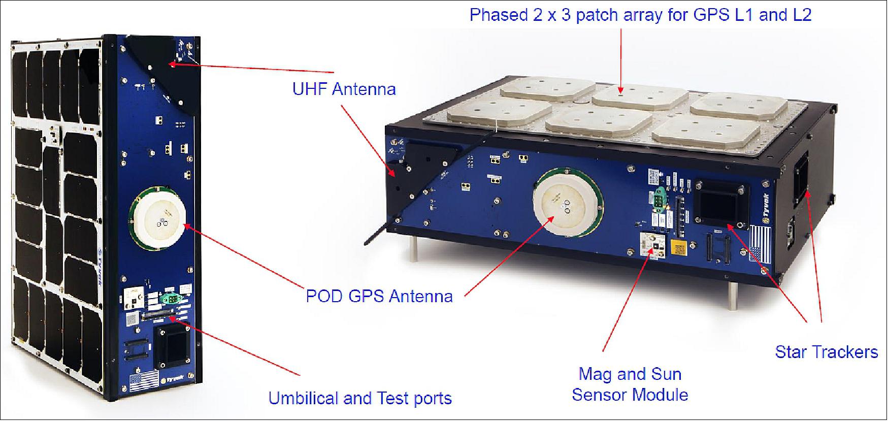
The CICERO satellites currently in orbit are 6U CubeSat nanosatellite models with a mass of approximately 10 kg. These satellites are 3-axis stabilised with a high-performance attitude determination and control subsystem featuring two-star trackers and three reaction wheels. CICERO satellites have very low EMI (electromagnetic interference), extensive RF (radio frequency) shielding, and a solar array which provides around 21 W of power. Satellite communication is provided via communications X-band downlink of payload data and UHF (ultra high frequency) up/downlink for TTC (Telemetry, Tracking and Command) data.
CICERO (Community Initiative for Continuing Earth Radio Occultation) pathfinder mission of GeoOptics
Mission Design Constellation Launch Mission Status Sensor Complement References
GNSS RO profiles provide robust, fundamental measurements of key variables required in climate research and weather forecasting. These data are also of great value in the study of “space weather” – disruptive storms in the ionosphere. GNSS RO has been particularly useful for NWP (Numerical Weather Prediction), providing a significant improvement in global forecasting over the past seven years.
The primary measurement made by GNSS RO is:
- atmospheric refractivity,
- a reflection of temperature,
- density,
- pressure,
- water vapour content. 1)
CICERO is a planned constellation of LEO (Low-Earth Orbiting) microsatellites for performing GPS and Galileo radio occultation (GNSS-RO) of Earth's atmosphere and surface remote sensing by GNSS reflection. The overall goal of the system is to deliver critical data on the state of the Earth to scientists and decision-makers worldwide. Products will include:
- high-accuracy profiles of atmospheric pressure, temperature, and moisture;
- 3D maps of the electron distribution in the ionosphere;
- a variety of ocean and ice properties.
Principal applications will be weather forecasting, climate research, and space weather monitoring. 2) 3) 4) 5) 6) 7) 8) 9)
The main objective of the CICERO pathfinder mission is to deploy two microsatellites to demonstrate the capabilities of the CICERO small satellite bus while enhancing weather and climate forecasting capabilities.
Orbit of the constellation: 500 km circular initial orbit, 750 km circular final orbit, inclination = 72º; later add 28º inclination. The altitudes and orbits are optimized to maximize the global distribution of occultation events.
• Phase 1: 6 orbital planes, 2 SC each (1st launch)
• Phase 2: 12 orbital planes, 2 SC each (2nd launch)
• Phase n: Missions of opportunity and other orbits.
Overview
In 2007, GeoOptics LLC, a commercial company of Pasadena, CA (founded in 2006), announced the operation of the CICERO project, which will eventually consist of 100 microsatellites in LEO (Low-Earth Orbit) performing GNSS-RO (Global Positioning System and Galileo atmospheric - Radio Occultation). 10)
Note: GeoOptics, an international consortium, was founded by working scientists to establish a new model of community-based space development for the public good that could change the way the world collects and disseminates Earth's observational data. The CICERO Project will inaugurate this model with a potent new technique for weather and climate sensing known as Global Positioning System Radio Occultation, or GPS-RO.
Until the launch of FormoSat-3 / COSMIC in April 2006, there had been little GPS-RO data available for performing forecast impact studies. The major source had been the German CHAMP satellite (launch July 15, 2000), which has delivered 150-200 profiles per day globally. Nonetheless, some evaluations were attempted.
A European team (Healy and Thépaut, 2006) added a mere 80 GPS profiles to a data set that included hundreds of thousands of standard satellite and ground measurements and 20,000 AIRS profiles, every 12 hours. The minuscule GPS data set boosted the total information content of the data by 4%, on top of a 10% increase provided by the AIRS data. On a per-profile basis, that's roughly 100 times the information content from GPS-RO than from any previous remote sensing measurement. 11) 12) 13)
GeoOptics partners in the CICERO consortium (Ref. 9):
• Broad Reach Engineering – Founding Partner, Instrument and Flight System Contractor, Mission Design, Marketing
• Moog Inc. (NY) – Propulsion systems, “green” propellant
• ESRI (Environmental Systems Research Institute, Redlands, CA) – Data systems and applications software
• CU / LASP (University of Colorado / Laboratory for Atmospheric and Space Physics, Boulder, CO) – Flight instruments, systems engineering, science research, constellation operations, education and outreach 14)
• University of North Dakota – Mirror operations & data center, science, engineering, education and public outreach
• MMA Design – Spacecraft mechanical systems development
• SRI – special ionospheric and space weather micro-sensors.
Contracts from NOAA for Commercial Data Purchase
• February 19, 2021: NOAA announced plans to dramatically expand the number of daily radio occultation soundings it acquires from commercial satellites operated by GeoOptics. 15)
- After an extensive pilot program, NOAA awarded two-year indefinite delivery-indefinite quantity contracts in November to GeoOptics and Spire Global with a combined ceiling of $23 million. At that time, NOAA also placed its first order, directing each company to provide 500 daily radio occultation soundings for 30 days.
- “NOAA successfully used the Delivery Order-1 data to verify data quality and formats and to conduct an end-to-end test flow of data through NOAA’s ingest, distribution, and archive systems and into Numerical Weather Prediction models,” according to a Feb. 19 news release from the NOAA Office of Space Commerce.
- Under the latest order, NOAA is directing GeoOptics to supply 1,300 daily radio occultation soundings from March to September. As part of the latest order, NOAA is obtaining a license to share the data immediately with U.S. government agencies and to share it publicly after 24 hours.
- “Following verification of data and system readiness, NOAA plans to begin incorporating commercial radio occultation data into operational numerical weather prediction models in May,” according to the news release.
- NOAA has not revealed the value of the first or second data delivery orders.
- To feed weather models, the companies must provide radio occultation data as soon as it’s acquired. NOAA has “stringent data quality, latency and reliability requirements,” GeoOptics noted in a Feb. 19 news release.
- “With strong support from Congress, NOAA has developed pioneering programs to include innovative, commercial data sources in its core forecast products,” GeoOptics CEO Conrad Lautenbacher, a former NOAA administrator, said in a statement. “After several years of technology development, testing and program formulation, NOAA’s commitment to operational use of commercial satellite data in safety-critical weather forecasts is a significant milestone for the commercial satellite data industry.”
- GeoOptics has three satellites in its operational fleet.
• In September 2016, NOAA made its first two awards under the Commercial Weather Data Pilot program created by Congress last year. The winners are Spire Global of San Francisco with the Lemur constellation and GeoOptics of Pasadena, CA with the CICERO constellation. Both will provide radio occultation data to NOAA for evaluation to determine whether commercial data can be incorporated into NOAA’s numerical weather models. 16) 17)
- Congress provided $3 million to NOAA in the FY2016 Commerce, Justice, Science appropriations act (Division B of the FY2016 Consolidated Appropriations Act) for the pilot program. It required NOAA to enter into at least one pilot project through an open competitive process to purchase, evaluate and calibrate commercial weather data and to submit a report on how it would implement the project. NOAA publicly released that report in April.
- The idea originated in the House-passed Weather Research and Forecasting Innovation Act (H.R. 1561) sponsored by Rep. Frank Lucas (R-OK) and Rep. Jim Bridenstine (R-OK). Bridenstine chairs the Environment Subcommittee of the House Science, Space, and Technology (SS&T) Committee and also serves on the House Armed Services Committee. He led efforts to include a provision in the pending FY2017 National Defense Authorization Act for DOD to create a similar program.
- Under the contracts, the two companies will provide GNSS radio occultation data to NOAA by April 30, 2017, to demonstrate data quality and potential value to NOAA’s weather forecasts and warnings. NOAA/NESDIS (National Environmental Satellite, Data, and Information Service) will assess the data through the end of FY2017 and issue a report in early FY2018. The contract award amounts were $370,000 for Spire and $695,000 for GeoOptics.
- NOAA already uses GPS radio occultation (GPO-RO) data in its forecasts. The data are acquired by the six-satellite Formosat/COSMIC constellation, a joint program with Taiwan. NOAA is requesting funds for a COSMIC-2 follow-on.
• Prior to the NOAA contract, Spire already built commercial demand for its services from other customers. In addition to other weather agencies, Peter Platzer, CEO of Spire Global, said there are multiple markets beyond just government that have an interest in limiting the economic impact of extreme weather events by using space-based observations. 18)
- “Our customers are organizations that are highly knowledgeable in the weather space that have the capability to run numerical weather prediction models, and hence have the skill to consume GPS-RO data. There are significantly more private organizations and nongovernmental organizations that actually have this capability than we were aware of,” said Platzer.
- Spire presented the world’s first commercially collected and processed GPS-RO profiles this year at the IROWG (International Radio Occultation Working Group) conference. Platzer said the company was able to demonstrate that a commercial company could collect GPS-RO profiles and perform the necessary processing to convert them to atmospheric profiles. While highlighting that this feat was something many doubted could be done commercially, Platzer quickly adds that Spire relied heavily on government-supported research from NOAA, NASA, the Alfred Wegener Institute, the DLR, and others.
• While GeoOptics and Spire Global were awarded this first contract by NOAA, another company, PlanetiQ of Boulder, CO, also has plans to launch weather satellites in early 2018.
Development Status
• July 29, 2021: GeoOptics is planning to deploy of the constellation of dozens of smallsats over the next five years to collect weather and other Earth science data for government and commercial customers. 19)
- The Pasadena, California-based company announced on July 29 that it will start launching next year a line of satellites called CICERO-2 that are upgraded versions of the CICERO satellites it has previously launched to collect global navigation satellite system (GNSS) radio occultation data used in weather forecasting.
- The CICERO-2 satellites will continue to collect GNSS radio occultation data, but will also receive GNSS signals reflected off the Earth to measure ocean winds, soil moisture and other surface conditions. NASA’s Cyclone Global Navigation Satellite System (CYGNSS), a set of eight smallsats launched in 2016, demonstrated that technology for studying tropical weather systems. The satellites will also be able to measure heavy precipitation through a technique called polarimetric radio occultation, again using GNSS signals.
- “All this is based on essentially one instrument in slightly different forms,” Alex Saltman, chief executive of GeoOptics, said in an interview. “By using that universal instrument, our observations are software defined rather than hardware defined.”
- While using a universal instrument, there will be some customization of the satellites. “Each satellite will likely make multiple measurements, but not all,” he said, depending on factors such as their orbits. While the original CICERO satellites were 6U CubeSats, the new satellites will be a mix of 6U and 12U CubeSats, with a few possibly larger.
- The first CICERO-2 satellites will launch in early 2022, with more to follow later in the year. The long-term goal is to launch about 50 over five years.
- Later satellites may carry additional instruments. GeoOptics is working on a radar instrument to measure ocean winds and other surface properties. That instrument, being developed with support from the National Oceanographic Partnership Program, could be ready for flight by the end of 2023, Saltman said. “The radar instrument is going to be a real workhorse for a wide variety of measurements, both government and commercial applications.”
- The company is also working on an approach to use smallsats to map the Earth’s gravitational field, much like the Gravity Recovery and Climate Experiment (GRACE) and the GRACE Follow On missions, which measure mass change linked to water movement. The Earth science decadal survey published in early 2018 recommended NASA pursue a successor to GRACE Follow On.
- That system, he said, would be developed in conjunction with NASA to implement the decadal recommendation, and the company has won NASA technology contracts for early-stage work on the concept. “We have an instrument design and we’re doing all the other work to prove out how the constellation would work.”
- Saltman said GeoOptics has sufficient funding to begin deployment of CICERO-2 satellites. Later satellites may be funded through some combination of cash flow or additional investment.
- GeoOptics expects revenues to come from a mix of government and commercial customers. In addition to potential NASA Earth science business, the company has a contract with the National Oceanic and Atmospheric Administration to provide GNSS radio occultation data for weather forecasting.
- “CICERO-2 is designed to help provide high-priority NOAA climate and weather monitoring observations,” Conrad Lautenbacher, executive chairman of GeoOptics and a former NOAA administrator, said in a statement. “It can also play a key role in supporting crucial Defense Department satellite weather data requirements.”
- The company also sees interest from commercial customers, such as Climavision, which is including GeoOptics data in forecasts it develops for customers in various industries. “We’re working with them to create weather forecasts for high-leverage customers, such as delivery companies and airlines, that need the absolute best forecasts,” Saltman said. “We’re seeing a lot of excitement in the marketplace for that product.”
- “Government markets are important, but they move slowly,” he said. “Commercial markets are perhaps less sophisticated to start with, but they’re also where a lot of the long-term growth is.”
CICERO Mission Design from a mMicrosatellite to a 6U CubeSat Form Factor
Originally, GeoOptics Inc. of Pasadena, CA, developed CICERO 115 kg microsatellites together with the UC/LASP (University of Colorado /Laboratory for Atmospheric and Space Physics) using the TriG GNSS-RO payload developed to fly on the FORMOSAT 7 / COSMIC-2 mission. Later during development, the massive miniaturization of the GNSS-RO payload, called CION (CICERO Instrument for GPS-RO), allowed the satellite design to be changed to a much smaller 6U CubeSat-based version built by Tyvak Nanosatellite Systems.
In 2016, Tyvak Nanosatellite Systems Inc. of Irvine, CA signed a contract with GeoOptics Inc. of Pasadena, CA, to build the first tech demo CICERO (Community Initiative for Continuous Earth Remote Observation) satellite. Spacecraft development is underway and will be ready to launch within a few months of the contract start date. 20)
Tyvak will utilize its core 6U Endeavor platform to provide the proper technical performance and mission assurance traits necessary for GeoOptics to carry forward its business plan of delivering data to scientists and decision-makers around the world from sensors deployed on a constellation of small satellites in low Earth orbit. GeoOptics’ quest to revolutionize data availability for earth science will finally move forward with this partnership.
“After exhaustive market research, Tyvak stood out as the company with the best technology and mentality to partner with. We couldn’t find anyone else with a comparable integrated approach well catered toward high performance and high reliability missions,” Thomas Yunck, Founder and CTO of GeoOptics stated.
The overall mission architecture, spacecraft design and development, payload integration, operations and data communication will be Tyvak’s responsibility. 21)
Nanosatellite evolution:
Nanosatellites have evolved to support powerful instruments for advanced operational capabilities and high mission utility.
- Operationally, they can fulfil a critical government or commercial missions within a substantial mission life of >3 years.
- High utility: high level of performance, reliability and confidence in mission success.
• Tyvak is developing the GeoOptics CICERO constellation of satellites
- Completed the first three satellites in the constellation
- Intended to gather vital data on the Earth's weather, climate and environment
• The program utilizes Tyvak's Endeavour small satellite platform
- 6U CubeSat, high-speed communications, 3-axis high-performance attitude control
- The CICERO constellation will test and demonstrate the newly developed instrument and the integrated satellites
• Data gathered will provide:
- Weather monitoring and forecasting information to NOAA (National Oceanic and Atmospheric Administration)
- Science and weather data to other government and commercial customers.
CICERO Radio Occultation Constellation
• Mission:
- Demonstration and the operational constellation of radio occultation observation satellites for a commercial customer
- Data products to be delivered to customers as part of a commercial data buy for near real-time weather data.
• Technologies developed and demonstrated
- Scientific RO (Radio Occultation) instrumentation made in collaboration with JPL
- Very low EMI (Electromagnetic Interference) spacecraft, extensive RF shielding
• Program challenges & experiences
- Low EMI requirement
- GPS antenna and RO payload development.

The CICERO-6 integrated 6U CubeSat has a mass of ~ 10kg, and a solar array providing ~ 21 W of power.
Size | 6U CubeSat |
Mass | ~ 10 kg |
Power | 21 W (orbital average) |
ADCS (Attitude Determination and Control Subsystem) | Full 3-axis stabilized, 2 Star Trackers, 3 reaction wheels |
Battery | 120 W hrs |
Communications | X-band downlink of payload data, UHF up/downlink for TTC data |
Designs Goals Achieved and General Capabilities
• Near 100% duty cycle
- Fixed deployable solar arrays to allow nearly 100% duty cycle operations of the CION (CICERO Instrument for GPS-RO) instrument
• Data capacity
- 2 Mbit/s X-band transmitter can downlink all RO data collected in 1 orbit along with associated back-orbit telemetry
- Compatibility with KSAT (Kongsberg Satellite Services AS) Network for fast data delivery
• Algorithms to target RO opportunities
- Calculated on the ground and then event scripts for vehicle slews for optimal RO opportunities are executed
- Will be automated on the vehicle using an onboard propagator in future batches
• GPS RO instrument improvements
- Updated software to support GLONASS
- Software upload and re-flash capabilities.
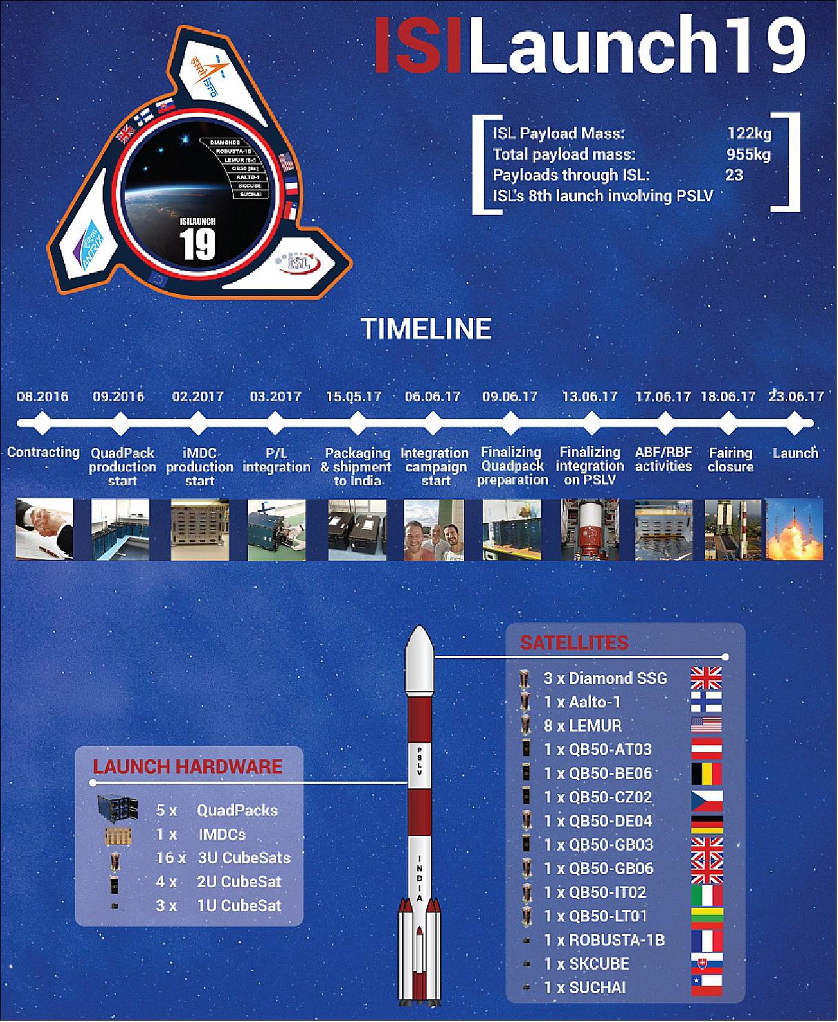
Launch
The CICERO-6 nanosatellite was launched on June 23, 2017 (03:59 UTC) as a secondary payload (co-passenger) on the PSLV-C38 vehicle in XL configuration of ISRO from SDSC (Satish Dhawan Space Center), India. The primary payload on this flight was CartoSat-2E (~712 kg), the sixth satellite in the Cartosat-2 series (total launch mass of ~955 kg). 22) 23)
Orbit: Sun-synchronous near-circular orbit, altitude of 505 km, inclination = 97.44º, LTDN (Local Time on Descending Node) at 9:30 hours.
Secondary Payloads: 30 satellites (co-passengers) with a total mass of 243 kg
The 29 international customer nanosatellites were launched as part of the commercial arrangements between Antrix (Antrix Corporation Limited), a Government of India company under DOS (Department of Space) and the commercial arm of ISRO and the International customers.
The Dutch company ISISpace (Innovative Solutions In Space) of Delft accommodated most of the secondary payloads aboard the multi-satellite launch (responsible for manifesting a total of 23 satellites on this particular launch). Engineers stowed the CubeSats in QuadPacks before shipping them to the Indian launch site. 24)
Among these 23 satellites, there are 8 CubeSats that will complement and complete the QB50 constellation for upper atmospheric research (www.qb50.eu). This project, sponsored by the European Commission’s FP7 is managed by the Von Karman Institute from Belgium and ISISpace has been one of the consortium partners of QB50 since the start. The CubeSats launched by ISISpace into polar orbit will work together with the CubeSats deployed from the International Space Station in May.
The ISILaunch19 manifest also includes several payloads that were initially scheduled for a launch on a Falcon 9 mission through Spaceflight’s Sherpa mission, a launch that was significantly delayed due to various factors.
ISL and Spaceflight have jointly worked on re-manifesting these payloads to this PSLV launch to make sure our customer’s satellites were launched earlier. Such a re-manifesting of payloads clearly shows the added value of the ISILaunch Services of ISISpace to serve the CubeSat community, offering access-to-space flexibility towards customers of launch services by operating across multiple launch vehicles and missions in parallel.
• NIUSAT (Noorul Islam University Satellite), located in Kumarakovil, Thuckalay, Kanyakumari District Tamil Nadu, India. NIUSAT is an Earth observation nanosatellite (15 kg). NIUSAT features a RGP camera with a ground resolution of 25 m and a frame size of 50 km x 50 km.
• CE-SAT-1 (Canon Electric Satellite-1), a microsatellite (50 kg) of Canon Electronics Space Technology Laboratory, Japan. The microsatellite features an optical imaging system based on a 40 cm diameter Cassegrain telescope.
• Max Valier, a nanosatellite (16 kg) of the "Max Valier" school Bolzano and the "Oskar von Miller" school Merano, in South Tyrol, Italy.
• D-SAT (Deorbit Satellite), a 3U CubeSat mission (3.5 kg) by the Italian company D-Orbit to demonstrate active end-of-life reentry.
• 3 Diamond nanosatellites (Blue, Green, Red) of Sky and Space Global, UK, developed by GomSpace ApS of Denmark. The three 3U CubeSats (each 6 kg) are pathfinders for Sky and Space Global's 200 Satellite LEO constellation.
• Pegasus, a nanosatellite (2U CubeSat) of FH Wiener Neustadt, Austria (thermosphere research). Pegasus is a member of the QB50 constellation with the m-NLP payload.
• InflateSail, a 3U CubeSat of SSC (Surrey Space Centre) at the University of Surrey, UK (technology demonstration nanosatellite). Part of the QB50 constellation. Inflatesail is designed to test a deployable sail as a means to deorbit the satellite. Inflatesail will use a 3.3 m sail at the end of a 1m boom deployed from the body of the satellite.
• UCLSat (University College London Satellite), a 2U CubeSat of UCL with the INMS (Ion and Neutral Mass Spectrometer), ionosphere research. UCLSat is part of the QB50 constellation.
• NUDTSat (National University of Defense Technology Satellite), Belgium, a 2U CubeSat of NUDT for ionosphere research. NUDTSat features a FIPEX instrument of the QB50 constellation.
• COMPASS-2 (DragSail CubeSat), a 3U CubeSat of FH Aachen, Germany (technology demonstration nanosatellite). COMPASS-2 is part of the QB50 constellation.
• LituanicaSAT-2, a 3U CubeSat of Vilnius University, Lithuania. The CubeSat is part of the QB50 constellation with a FIPEX payload.
• URSA MAIOR (University of Rome la SApienza MicroAttitude In ORbit testing), a 3U CubeSat to study the lower thermosphere. USRA MAIOR is a member of the QB50 constellation with the m-NLP payload.
• VZLUSat-1, a 2U CubeSat Czech technology nanosatellite of VTLU, developed in cooperation with Czech companies (RITE, HVP Plasma, 5M, TTS, IST) and universities (CVUT, University of West Bohemia). The nanosatellite carries on board the following experiments: a miniaturized X-ray telescope, composite material for radiation shielding, FIPEX, and a QB50 instrument, to measure the concentration of oxygen in the thermosphere.
• SUCHAI-1 (Satellite of the University of Chile for Aerospace Investigation), a 1U CubeSat (1 kg).
• Venta-1, a nanosatellite (7.5 kg) of Ventspils University, Latvia, developed by Ventspils University College in cooperation with Ventspils High Technology Park, Bremen University of Applied Sciences and OHB Systems. Venta-1 carries an AIS (Automated Identification System ) receiver, which will pick up identification signals from ships at sea.
• Aalto-1, a Finnish student nanosatellite (3U CubeSat) of Aalto University, Aalto, Finland.
• ROBUSTA-1B (Radiation on Bipolar Test for University Satellite Application), a nanosatellite with a scientific experiment developed by the University of Montpellier students (France), a successor to the ROBUSTA satellite, which was launched in February 2012.
• skCube, a 1U CubeSat for educational and popularization outreach developed by SOSA (Slovak Organization for Space Activities ) at the University of Zilina. It is Slovakia's first satellite.
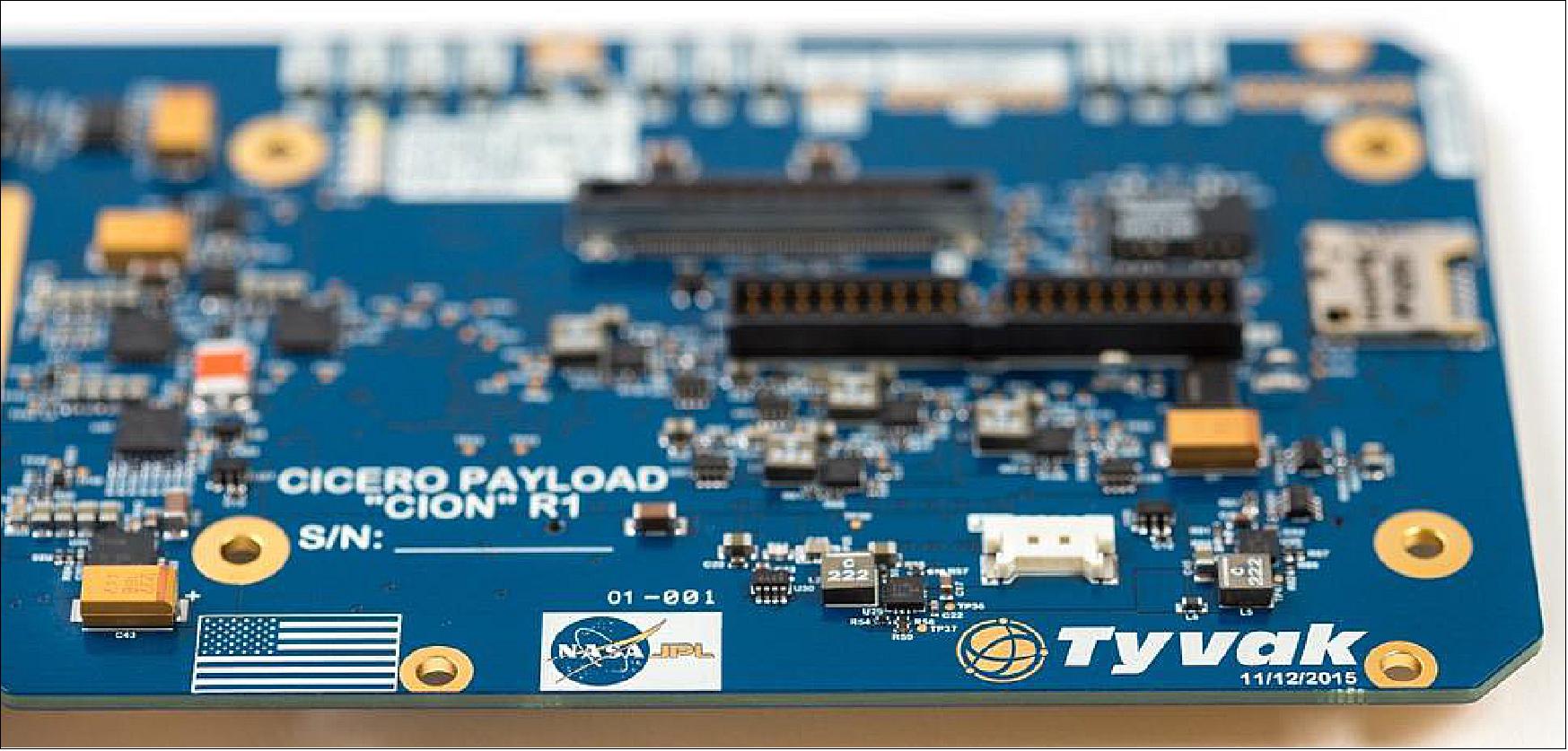
• CICERO-6 (Community Initiative for Cellular Earth Remote Observation-6), a 6U CubeSat of GeoOptics Inc. (~10 kg), Pasadena, CA, built by Tyvak Nanosatellite Systems. The objective is to demonstrate radio occultation observations for a commercial customer. CICERO-6 features CION (CICERO Instrument for GPS-RO) with a mass of 1.2 kg.
• Tyvak-53b, a technology 3U demonstrator by Tyvak Nanosatellite Systems, Inc. (Irvine, CA) to validate technology aimed at helping to deorbit small satellites.
• Lemur-2 x 8. Lemur-2 is a commercial satellite constellation of Spire Global Inc., San Francisco, CA, The objective of the Lemur-2 constellation is ship tracking via AIS (Automatic Identification System) with SENSE. The STRATOS instrument makes use of GPS occultation measurements to determine temperature, pressure and humidity profiles of Earth’s atmosphere for application in operational meteorology.
Launch:
The Kanopus-V-IK satellite cluster mission for Roscosmos, along with 72 secondary payloads, among them three CICERO 6U CubeSats (CICERO-1, -2 and -3), were launched on July 14, 2017 (06:36:49 UTC, 09:36:49 Moscow time) on Soyuz-2.1a / Fregat-M vehicle from the Baikonur Cosmodrome in Kazakhstan. 25) 26) 27) 28) 29)
Over the 8+ hour mission, a total of 72 commercial and university smallsats were injected into three unique orbits, with the subsequent de-orbiting of the booster.
Orbit: Injection of the primary payload and smallsats into 3 different orbits (the orbit of Kanopus-V-IK is ~ 500 km, the orbit of Flying Laptop is 600 km, and the orbit of Dove 3U CubeSats is 475 km).
Secondary payloads: In total, 72 secondary satellites will be launched on the Kanopus-V-IK mission, including spacecraft for four separate commercial remote sensing and weather constellations.
Glavkosmos, a subsidiary of Russian state space corporation Roscosmos, is seeking to become a larger provider of rideshare launch services for small satellites. In addition to this upcoming launch, Glavkosmos is planning to fly about 40 more small satellites on two Soyuz missions from the new Vostochny Cosmodrome in Russia’s Far East region late this year, with additional launch opportunities planned for 2018 and beyond.
In addition, the German Orbital Systems company of Berlin, ECM Space Technologies GmbH, actively participates in the launch, by supplying a DCSM (Deployment Control and Separation Sequence Management) unit. Integration of two secondary satellites built in Germany, three from Russia and 12 from the USA. GlavKosmos subcontracted this task to ECM. 30)
• Forty-eight (48) Dove satellites (Flock 2k) of Planet will be launched into an SSO of 485 km altitude. 31) Planet of San Francisco is the biggest single customer for the upcoming launch. This “flock” of 48 satellites will go into a sun-synchronous orbit, but one slightly different from those of 88 similar satellites launched on an Indian Polar Satellite Launch Vehicle in February. Those satellites went into a sun-synchronous orbit that crosses the equator at 9:30 hours local time. The new satellites will launch into an orbit that crosses the equator at about 11:00 hours local time.
• Spire Global of San Francisco, which is deploying a fleet of CubeSats to collect GPS radio occultation and ship tracking data, has eight (8) of its Lemur CubeSats on this launch.
• GeoOptics of Pasadena, CA, is flying its three CICERO 6U CubeSats (CICERO-1, -2,- 3), designed to collect GPS radio occultation data to support weather forecasting.
• Flying Laptop, a minisatellite (120 kg) of IRS (Institute of Space Systems), University of Stuttgart, Germany.
• WNISAT- 1R (Weather News Inc. Satellite 1R), a microsatellite (43 kg) for north arctic routes and atmosphere monitoring. The project started from the commercial objects between Weathernews and Axelspace, Japan. The object of the WNISAT-1R mission is the monitoring of the Northern sea routes and of the CO2 content of the atmosphere. 32)
• NorSat-1 and NorSat-2 of the Norwegian Space Center, built by UTIAS/SFL (Canada) on GNB (Generic Nanosatellite Bus), each with a mass of 15 kg. The NORSAT-2 satellite will carry a next-generation Automatic Identification System (AIS) receiver from Kongsberg Seatex, along with a VDE (VHF Data Exchange) payload that will enable two-way communication at higher data rates than possible with AIS. NorSat-1 (< 30 kg) carries three instruments: An AIS receiver, a Langmuir Probe Instrument, and CLARA (Compact Lightweight Absolute Radiometer), intended to observe total solar irradiation and variations over time.
• TechnoSat is a nanosatellite project (18 kg) of the Technical University of Berlin. Test of new nanosatellite components, including a camera, a new reaction wheel system, a star tracker, a transmitter, a fluid dynamic actuator, and commercial laser retro-reflectors.
• Corvus-BC 1 and Corvus-BC 2: Astro Digital, formerly known as Aquila Space, (formed from the core team of the former Dauria Space daughter Canopus Systems) developed the Corvus-BC Earth observation CubeSats (6U, 10 kg). The Landmapper-BC spacecraft, also known as Corvus-BC1 and Corvus-BC2, have colour and infrared cameras for wide-area imaging.
• MKA-N 1, 2: Two Earth observation CubeSats (6U, 10 kg each) of Roskosmos, built by Dauria Aerospace.
• NanoACE, a technology demonstrator by Tyvak Nanosatellite Systems, Inc. (Irvine, CA) to validate the Endeavor suite technologies that will be used for future missions and is solely for the purpose of internal Tyvak development as an attitude control experiment. A 3U CubeSat (5.2 kg).
• Mayak: A Russian 3U CubeSat (4kg) developed by a group of young scientists named "Your sector of space" with the support of the Moscow State University of Mechanical Engineering (MSUME). In orbit, the 3U CubeSat will deploy four triangular reflectors, 4 m2 each, which form a tetrahedral shape. The reflectors are made from a metalized membrane with a reflection coefficient of 95%. The reflector will provide a -10 optical magnitude at the beginning of the flight to allow for easy tracking. Mayak will be put into a tumbling motion over all axes, with at least 1 revolution per second.
• Iskra-MAI-85, a CubeSat of the Moscow Aviation Institute. 33)
• Ecuador-UTE-YuZGU, a CubeSat of the Kursk South-Western State University, Russia.
Launch:
On November 11, 2018 (03:50 GMT), Rocket Lab launched its Electron rocket from the company’s Launch Complex 1 on New Zealand’s Mahia Peninsula into a 500 km orbit at 85º inclination. Rocket Lab called this flight ”It's Business Time.” The CICERO-4 3U CubeSat, built by Tyvak Nanosatellite Systems for the weather satellite constellation company GeoOptics, was part of this launch. 34)
Further CubeSats on this flight were:
- Two Lemur-2 CubeSats of Spire, which operates a constellation of such spacecraft to collect weather data as well as track vessels and aircraft.
- IRVINE-01, a CubeSat built by high school students in Southern California. IRVINE-01 features an electric propulsion system developed by Accion Systems, marking the first flight of that company’s technology.
- Proxima-1 and Proxima-2, are 1.5 U pathfinder CubeSats of Fleet Space Technologies of Adelaide South Australia. The Australia-based IOT (Internet of Things) startup will use the two Fleet-built Proxima satellites as the beginning of a constellation (named Centauri) designed to provide Internet connectivity for millions of devices across the globe.
- NABEO, a 1U CubeSat. NABEO is a drag sail technology demonstrator built by HPS GmbH (High-Performance Space Structure Systems GmBH) of Munich, Germany, with support of the state of Bavaria, which will test the ability to passively deorbit inactive, small satellites using atmospheric drag.
Mission Status
• July 14, 2022: The National Oceanic and Atmospheric Administration (NOAA) awarded contracts to GeoOptics, PlanetIQ and Spire Global to provide space weather data as part of a pilot program to test the value of the commercial observations. 35)
- “The awards represent NOAA’s next step toward working with the commercial sector to obtain and analyze space weather data to meet its critical space weather forecasting mission,” according to NOAA’s July 14 news release.
- Under the contracts, the three companies will provide NOAA with radio occultation datasets that reveal weather conditions in Earth’s ionosphere. NOAA’s goal is to determine the impact the commercial datasets would have on existing and anticipated future operational space weather models and applications.
- Over approximately 12 months, NOAA will evaluate data supplied by GeoOptics, PlanetIQ and Spire. Then, NOAA may opt to purchase commercial space weather data to support operational forecasting.
- NOAA began soliciting vendors in the first round of the Commercial Weather Data Pilot in 2016. The initial program focused on the value of radio occultation soundings, which reveal atmospheric temperature, pressure and moisture, in improving terrestrial weather forecasts.
- Since 2020, NOAA has been purchasing radio occultation data to improve terrestrial weather forecasts from GeoOptics and Spire.
- NOAA signalled its intention to begin evaluating space weather data with a request for proposals issued in May.
- Congress prompted NOAA to establish a commercial space weather data pilot program in the PROSWIFT Act, space weather legislation enacted in 2020. (PROSWIFT stands for Promoting Research and Observations of Space Weather to Improve the Forecasting of Tomorrow.)
- “GeoOptics is excited to be working with NOAA to show that we can continue to deliver the reliable and timely satellite space weather data the nation needs to protect our national infrastructure and support the most accurate space weather forecasts,” Conrad Lautenbacher, GeoOptics executive chairman, told SpaceNews by email.
- Chuck Cash, Spire vice president of federal sales, said Spire, with a constellation of more than 100 multipurpose satellites, is the largest producer of radio occultation data, which he called “a powerful component of highly accurate, modern weather forecasting.”
- “We’ve provided radio occultation data to NOAA for over three years and are thrilled to expand our relationship to provide data for space weather forecasting research, which will lead to safer and more efficient operations of planes and spacecraft,” Cash said by email.
- PlanetIQ founder Chris McCormick said by email, “We are thrilled to be working with NOAA on this, and are anxious to see the impact of our new 4th generation GNSS-RO receiver has in an operational environment.”
• November 23, 2020: NOAA (National Oceanic and Atmospheric Administration) awarded its first contracts on Nov. 20 to purchase GPS-RO (Radio Occultation) data from commercial satellite operators GeoOptics and Spire Global. 36)
- The Nov. 20 awards are the culmination of years of work by both companies to develop, manufacture and operate satellites to gather atmospheric temperature, pressure and water vapour observations to feed into operational weather forecasts.
- The two-year indefinite delivery-indefinite quantity contracts awarded to GeoOptics and Spire Global have a total ceiling of $23 million. On Nov. 20, NOAA also awarded initial task orders to both companies but did not reveal the value of those orders.
- Since 2016, NOAA has scrutinized radio occultation data provided by private companies through the Commercial Weather Data Pilot. In June, the agency issued a report that concluded, “the commercial sector is capable of providing the quality of data needed to help support NOAA’s operational weather forecasting needs.”
- NOAA has a target of acquiring 20,000 soundings per day, Steve Volz, NOAA assistant administrator for satellite and information services, said in January at the American Meteorological Society’s conference in Boston. A significant portion of the data is likely to come from the six satellites that make up the second U.S.-Taiwan Constellation Observing System for Meteorology, Ionosphere and Climate (COSMIC) constellation launched in 2019.
- Spire Global operates a constellation of more than 100 Lemur CubeSats with multiple sensors to track ships at sea, and aircraft in flight in addition to obtaining atmospheric data by noting how signals from global navigation satellites like GPS travel through the atmosphere.
- “We are pleased that NOAA has selected Spire for the operational procurement of radio occultation,” Keith Johnson, Spire Global vice president and general manager – federal, told SpaceNews by email. “Our missions are synergistic and we look forward to a long and happy partnership. We believe this represents both an amazing third-party validation as it deeply illustrates the kind of collaboration that is possible between public and private institutions to support such a critical service for people and businesses around the world.”
- GeoOptics focuses exclusively on weather data with a smaller constellation of CubeSats called CICERO (Community Initiative for Cellular Earth Remote Observation) that are roughly twice the size of Lemurs. GeoOptics does not publicly discuss the size of its constellation.
- “GeoOptics is very pleased and excited about our new contract with NOAA,” GeoOptics CEO Conrad Lautenbacher told SpaceNews by email. “We look forward to providing top-of-the-line radio occultation data for use in National Weather Service forecasts.”
- During the Commercial Weather Data Pilot, NOAA evaluated data from 12 Lemurs and two CICEROs.
• April 15, 2020: GeoOptics, Inc. has launched an original radio occultation data processing system called the GeoOptics Processor for Radio Occultation (GeoPRO) that provides even more accurate and timely weather data from its CICERO constellation of radio occultation (RO) satellites. CICERO satellites are designed to create the most detailed picture ever assembled of the Earth's ionosphere and atmosphere. 37)
- For many years, detailed scientific analyses of radio occultation data have used a precise processing method called "phase-matching" to produce the most accurate radio occultation profiles possible. However, this method was generally considered resource intensive for use in real-time data processing for operational weather modelling and forecasting.
- GeoOptics has developed GeoPRO as a real-time phase-matching processing system built around the on-demand parallelism enabled by serverless cloud-computing services, sometimes referred to as "Serverless Supercomputing." By optimizing the processing system and running it on massively parallel serverless infrastructure, GeoPRO enables near-real-time phase-matching processing of large quantities of radio occultation data.
- Traditionally the processing of radio occultation data has been undertaken in a batch processing mode in which relatively large chunks of data are processed together and then released. However, as the number of GeoOptics satellites and ground stations increases, data will arrive much more frequently, requiring a different mode of operations to minimize data latency and maximize utility. GeoPRO is designed to make that transition possible.
- Data from the new processing system have been made available to scientists around the world and GeoOptics commercial data partners. Due to the accuracy of the data processing and the quality of the CION receiver, the data exhibits remarkably low bias even in warm air near the Earth's surface, where lower-quality radio occultation data often suffer from uncontrolled biases. Research has shown that this degree of accuracy in the lower atmosphere is vital for forecasting hurricanes and other high-impact weather events.
- GeoOptics' mission is to provide the most detailed picture possible of our planet's atmosphere, surface and subsurface to our customers as well as scientific users around the world. We have embarked on our mission with our first constellation of nanosatellites, known as CICERO – Community Initiative for Cellular Earth Remote Observation. The first operational satellites contain advanced Global Navigation Satellite System Radio Occultation (GNSS-RO) sensors developed in partnership with the Jet Propulsion Laboratory (JPL) and Tyvak Nano-Satellite Systems.
- With the company's initial CICERO satellites on orbit, GeoOptics is now providing the first and only high-quality commercial radio occultation data from space. Satellites now in work will expand upon and refine this capability and deploy other technologies to provide a comprehensive picture of the Earth’s environment.
- Dr Alex Saltman, COO (Chief Operating Officer) and architect of the new processing system related that the company is excited to provide this newly refined data to customers who depend on getting the most timely and precise weather data possible. The firm is leveraging new technologies across the GeoOptics satellites, ground systems and now data processing to deliver best-in-class data as a service to the government and commercial customers.
• January 15, 2020: On January 11, 2018, GeoOptics launched the first of its operational CICERO satellites for atmospheric radio occultation (RO). RO is a potent technique for sensing the atmosphere for improved weather forecasting accuracy, first proposed by GeoOptics founder and CTO (Chief Technology Officer) Tom Yunck more than 30 years ago. The technique works by precisely observing the signals of GPS and other navigation satellites as the signals pass through the Earth’s atmosphere. 38)
- “We couldn’t be happier with how our team has performed over the last two years, both at GeoOptics and at our partners,” said GeoOptics CEO Conrad Lautenbacher. “I am confident that 2020 will see many new accomplishments — new launches, new capabilities, and new partners and applications for our high-quality global atmospheric data.”
- Over the last two years the CICERO team, which includes key partners at the Jet Propulsion Laboratory (JPL) and Tyvak Nano-Satellite Systems, has achieved the following significant milestones:
1) High-quality occultations – From the first occultations gathered in 2018, it was clear that CICERO would deliver exceptionally high-quality data. The quality of radio occultation data is primarily demonstrated by an absence of measurement bias, as well as by how low in the atmosphere the profiles penetrate. Based on the many occultations that have now been gathered, we now know that CICERO data reaches down to a median altitude of just 1,000 meters above sea level with minimal bias – virtually none above 3,000 meters.
2) First GLONASS occultations – In April 2018, via an on-orbit software update, CICERO began collecting occultation data from Russian GLONASS navigation satellites in addition to GPS, recording the first science-quality GLONASS occultations ever taken from Earth orbit.
3) Over 500 occultations per day – In May 2018, CICERO began producing more than 500 high-quality occultations per day, the world’s first nanosatellite to approach and surpass this milestone.
4) Data Deliveries to NOAA – On October 31, 2018, GeoOptics began near-real-time data deliveries to NOAA under our $3.44 million contract from the Commercial Weather Data Pilot program. Over the following year CICERO delivered a total of 356,490 high-quality occultations, each just a few hours after it was gathered. GeoOptics completed its contracted data deliveries to NOAA in September 2019.
5) Additional satellites – In November and December 2018, GeoOptics launched additional CICERO satellites. As a demonstration of the constellation’s agility, and with support from the expert operational team at Tyvak, these satellites were deployed, began operations and provided data to partners within hours of launch. Additional CICERO satellite launches will continue in 2020.
6) Ground operations developments for low latency – In the past year GeoOptics has significantly reduced data latency by expanding the CICERO ground stations network across the world, as well as by developing a ground processing platform that streams live occultation data from downlinks into processing as soon it is received, before the end of each pass.
- “Our team has developed strategies for continuous development and deployment across our entire data system, from the satellites to the ground stations, data processing and delivery platform,” said Chief Operating Officer Alex Saltman. “We have taken tools originally designed for Agile web development and adapted them to enable reliable operation of science data streams with an agility that is new to the satellite industry.”
- CICERO nanosatellites are designed to create the most detailed picture ever assembled of the Earth’s ionosphere, atmosphere, surface and subsurface. The first operational satellites contain advanced Global Navigation Satellite System Radio Occultation (GNSS-RO) sensors developed in partnership with JPL and Tyvak.
- Yunck noted that “radio occultation has been shown to have ten times the impact on weather forecasting accuracy per sounding when compared to any other satellite-based Earth observation, and at a far lower cost. Large commercial RO satellite constellations will inaugurate a new era of weather forecasting excellence.”
- New CICERO satellites, which are now in work with launches starting in the next few months, will expand upon this technology and carry complementary sensors to help provide our data partners with a complete picture of the Earth’s environment.
• September 20, 2018: The National Oceanic and Atmospheric Administration awarded more than $8 million in contracts this week to three companies in the second round of a commercial satellite weather data pilot program. 39)
- In the Sept. 17 announcement, NOAA said it was issuing contracts to GeoOptics, PlanetIQ and Spire to provide GPS radio occultation weather data from satellites currently in orbit or planned for launch in the coming months. That technique measures the refraction of GPS signals as they pass through the atmosphere and are received by the companies’ satellites, which can provide temperature and pressure profiles to support weather forecasting models.
- The awards represent round two of NOAA’s Commercial Weather Data Pilot program, an effort by the agency to experiment with buying data from commercial providers to determine its usefulness, as well as to examine various technical and programmatic issues with such data buys.
- “These contracts represent another step toward bringing commercial sector innovation to NOAA’s mission of delivering life-saving weather forecasts and warnings,” said Karen St. Germain, director of the Office of Systems Architecture and Advanced Planning for NOAA’s Satellite and Information Service, in a statement. “By collaboratively testing commercial sector capabilities and new business models, we continue to optimize the impact of our observations and reduce costs for taxpayers.”
- In round one of the program, NOAA awarded contracts valued at a little more than $1 million in September 2016 to GeoOptics and Spire. However, GeoOptics could not provide any data because its first satellites had not launched before the window for providing data under the contract closed in April 2017.
- GeoOptics, which received a $3.44 million contract in round two of the program, now has at least two of its Cicero satellites in orbit, launched as secondary payloads on Polar Satellite Launch Vehicle missions in June 2017 and January 2018. A third awaits launch on a Rocket Lab Electron mission now scheduled for November after a series of technical issues with the rocket. Three others were launched on a Soyuz in July 2017, but are believed to be among the several satellites on that mission that failed after reaching orbit.
- “We look forward to working with NOAA to demonstrate the power of GeoOptics’ CICERO constellation to deliver reliable, high-quality data for weather forecasting,” said Conrad Lautenbacher, chief executive of GeoOptics and a former NOAA administrator, in a statement.
- Spire, which did provide data to NOAA under its earlier contract, received the smallest of the three awards, at $1.425 million. However, Spire Chief Executive Peter Platzer said he was not concerned about the size of the contract.
- “We are definitely celebrating winning yet another contract from NOAA,” he said Sept. 20. “Since Spire is the only company that has successfully delivered to NOAA already, I think NOAA decided they didn’t need as long a performance period from us and instead needed to focus the second test more heavily on unproven companies.”
- PlanetIQ, the newcomer to the program, also received the largest award, at $3.5 million. The Golden, Colorado-based company has yet to launch any satellites, even as its website states that it plans to have “12 microsatellites on orbit by early 2018.”
- Steve Joanis, chief executive of PlanetIQ, said Sept. 19 that the company plans to launch its first two satellites in the first or second quarter of 2019. He did not state when the company expected to have its full constellation in orbit, or its size.
- Under the new contracts, the companies will deliver data through July 2019, with new “additional operational considerations” regarding the delivery of the data. The agency plans to complete its assessment of the data received and produce a final report by spring 2020.
• March 12, 2018: Tyvak has announced that another 6U nanosatellite for GeoOptics’ commercial weather monitoring constellation has successfully deployed and delivered data to the customer in record-breaking time. The 10 kg satellite launched from India’s Polar Satellite Launch Vehicle (PSLV), joining the rest of the CICERO constellation in low earth orbit. 40)
- The platform awoke and registered a valid GPS fix a mere thirty seconds after powering on and achieved full 3-axis active pointing minutes later while awaiting ground contact. Tyvak progressed through commissioning and proceeded to deliver the first set of scientific data to GeoOptics within eight hours of separation, outperforming the most recent CICERO’s data-downloading record.
The vehicle continues to operate nominally with all systems fully operational. This accomplishment is the latest in a string of successes, highlighting the record-setting progression of the Tyvak platforms and further validating the Company’s dedication to redefining operational responsiveness and Agile Space.
- “We are all extremely excited about the satellite’s performance,” said Marco Villa, Tyvak’s COO. “We are proud of the team’s ability to autonomously operate diverse satellites in a constellation. Our systems have proven to be consistently reliable with fully capable, optimizable solutions for a vast array of customer needs. We look forward to continuing to earn our customers’ trust and celebrating additional successful missions in 2019.”
• August 29, 2017: Four of the 72 miniature satellites sent into orbit on July 14 on a Russian Soyuz 2.1a rocket alongside the primary customer, the Kanopus-V-IK Russian Earth-imaging satellite, are not responding to commands from their operators and two additional cubesats are not in their intended orbits. 41)
- Dauria Aerospace, Russia’s first privately owned and operated satellite manufacturing company, announced on Aug. 29 that it has been unable to establish contact with the two MKA-N CubeSats the firm designed and built for the Russian state space corporation Roscosmos.
- Tyvak officials did not respond to requests for comment. Alex Saltman, GeoOptics' chief operating officer, said via email, “We have a company policy of not commenting on the status of individual satellites or launches.”
Sensor Complement
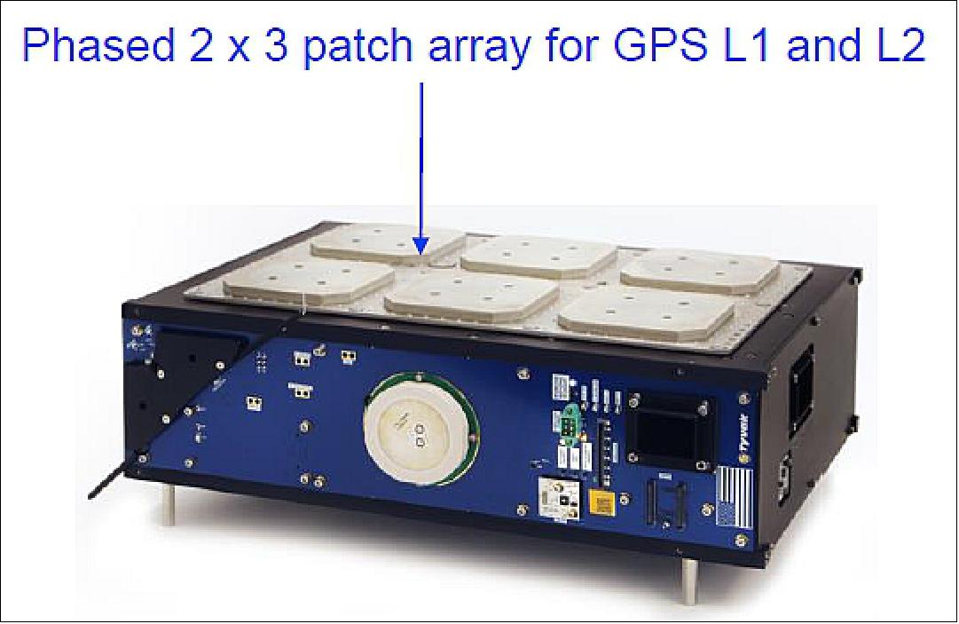
CION (CICERO Instrument for GPS-RO)
• Key challenges & experiences (Ref. 21).
- Miniaturize the instrument from a power and mass perspective but ensure end data product quality and support essential JPL heritage software compatibility
- The quality and effectiveness of collaboration are far superior when the collaborators are within driving distance. JPL has been on site for system test verifications and design reviews.
• CION instrument features
- RF inputs: 3 antenna inputs with 4 down converters each
- Processor: 1.2 GHz dual-core Arm processor
- RAM: 1 GB flash: up to 256 GB
- DSP: Programmable FPGA for digital signal processing
- Sub-channels: 16 GPS (8 dual frequency satellites)
- External clock: High-performance oscillator (10 MHz, ~ 5 x 10¹²)
- External PPS (Precise Positioning Service) output and external event input
• Accommodations of CION
- Volume: 3U available
- 30 cm x 10 x x 6 cm utilized by final payload configuration
- Mass: 1.2 kg
- Power: 8 W at 12 VDC
- Communication interfaces available: Two RS 422, USB and Ethernet
• Antenna incorporates combiner into the phased array
- Eliminated the need for an external RF combiner
- Eliminates the need for complex coax harnessing and associated mass
• EMI/EMC
- Bus design has an RF gasket enclosure to prevent EMI
- Payload resides in its own separate volume within the 6U Cubesat
• External inputs
- Temperature-controlled highly stable crystal oscillator for precise data clocking and timing
- External GPS for position, orbit determination
• Collection rate
- 1 kHz, 100 Hz, or 50 Hz native data collection rate from all channels.
References
1) Lee Jasper, Danielle Nuding, Elliot Barlow, Erik Hogan, Steven O'Keefe, Pete Withnell, Thomas Yunck, “CICERO - A Distributed Small Satellite Radio Occultation Pathfinder Mission,” Proceedings of the 27th AIAA/USU Conference, Small Satellite Constellations, Logan, Utah, USA, Aug. 10-15, 2013, paper: SSC13-IV-5, URL: http://digitalcommons.usu.edu/cgi/viewcontent.cgi?article=2936&context=smallsat
2) Thomas P. Yunck, “A Brisk Tour of GPS Radio Occultation - Past, Present and Future,” May 17, 2007, URL: http://www.jcsda.noaa.gov/documents/seminardocs/JCSDASeminarYunck051707.pdf
3) http://www.geooptics.com/GeoOptics/_Frames.html
4) C. McCormick, C. Lenz, D. Smith, T. Yunck, “Community Initiative for Continuing Earth Radio Occultation CICERO,” Proceedings of the 21st Annual AIAA/USU Conference on Small Satellites, Logan, UT, USA, Aug. 13-16, 2007, SSC07-I-3
5) Thomas P. Yunck, Chris C. McCormick, “CICERO: A Community Initiative for Continuing Earth Radio Occultation,” http://www.cosmic.ucar.edu/oct2007workshop/abstracts/Yunck_COS_WS_Abs.pdf
6) Christian Lenz, “The CICERO Constellation for Continuing & Sustainable RO Observations,” Oct. 13, 2008, URL: http://www.cosmic.ucar.edu/gnssro/presentations/25_LenzCICERO_Christian_Lenz.ppt
7) Turner Brinton, “NOAA, Taiwan Developing Plan for Weather Satellite Program,” Space News, April 12, 2010, p. 30, URL: http://www.spacenews.com/civil/100409-noaa-taiwan-plan-weather-satellite-program.html
8) http://geooptics.com/?page_id=58
9) Thomas P. Yunck, Chris C. McCormick, Christian Lenz, “CICERO - Community Initiative for Continuing Earth Radio Occultation, A Community Cooperative for Earth Science,” International Workshop on GNSS Remote Sensing, Shanghai, China, Aug. 7-9, 2011, URL: http://202.127.29.4/gnss/PPT_GNSSRS2011.pdf
10) http://geooptics.com/?page_id=58
11) Thomas P. Yunck, “A Brisk Tour of GPS Radio Occultation - Past, Present and Future,” May 17, 2007, URL: http://www.jcsda.noaa.gov/documents/seminardocs/JCSDASeminarYunck051707.pdf
12) Shuanggen Jin, G. P. Feng , S. Gleason, “Remote sensing using GNSS signals: Current status and future directions,” Advances in Space Research, Vol. 47, 2011, pp. 1645-1653 [web source no longer available]
13) T. P. Yunck, “CICERO: Community Initiative for Continuing Earth Radio Occultation,” IROWG (International Radio Occultation Working Group) Annual Meeting, Estes Park, Colorado, USA, March 28-April 3, 2012, URL: http://www.irowg.org/docs/Presentation/yunck.pdf
14) “GeoOptics LLC and CU-Boulder Create a Partnership Around the CICERO System of Earth Satellites,” Dec. 4, 2009, URL: http://www.prweb.com/releases/2009/12/prweb3295414.htm
15) Debra Werner, ”NOAA expands purchase of commercial radio occultation data for weather models,” SpaceNews, 19 February 2021, URL: *https://spacenews.com/noaa-expands-radio-occultation-order/
16) Marcia S. Smith,”Spire, GeoOptics Win First NOAA Commercial Weather Data Contracts,” SpacePolicyOnline.com, Sept. 16, 2016, URL: http://www.spacepolicyonline.com/news/spire-geooptics-win-first-noaa-commercial-weather-data-contracts
17) Jason Samenow, ”NOAA awards first-ever satellite data contracts to private industry,” Washington Post, Sept. 16, 2016, URL: https://www.washingtonpost.com/news/capital-weather-gang/wp/2016/09/16/noaa-awards-first-ever-satellite-data-contracts-to-private-industry/?utm_term=.f20614578f48
18) Caleb Henry, ”Spire CEO: We are Launching Satellites Every Month,” Satellite Today, October 26, 2016, URL: http://www.satellitetoday.com/nextspace/2016/10/26/spire-ceo-launching-satellites-every-month/
19) Jeff Foust, ”GeoOptics to launch next-generation Earth science constellation,” SpaceNews, 29 July 2021, URL: https://spacenews.com/geooptics-to-launch-next-generation-earth-science-constellation/
20) ”TYVAK a Terran Orbital Company Signs Contract to Build First Tech Demo CICERO Satellite,” Tyvak 2016, URL: https://web.archive.org/web/20170629034917/http://www.tyvak.com/tyvak-a-terran-orbital-company-signs-contract-to-build-first-tech-demo-cicero-satellite/
21) Dave Williamson, ”Small Satellites: The Execution and Launch of a GPS Radio Occultation Instrument in a 6U Nanosatellite,” 33rd Space Symposium, Colorado Springs, CO, USA, April 3-6, 2017, URL of presentation: https://www.spacesymposium.org/wp-content/uploads/2017/10/Williamson_Dave_GPS_Radio_Occultation_Talk-v1.pdf
22) ”PSLV-C38 / Cartosat-2 Series Satellite,” ISRO, June 23, 2017, URL: http://www.isro.gov.in/launcher/pslv-c38-cartosat-2-series-satellite
23) ”Indian Launch Manifest of April 15, 2017,” URL: http://www.sworld.com.au/steven/space/india-man.txt
24) Andra, ”Successful ISILaunch19 campaign,” ISILaunch19, June 23, 2017, URL: http://blog.isilaunch.com/successful-isilaunch19-campaign/
25) ”ROSCOSMOS: Soyuz-2.1a Launch Vehicle with KANOPUS-V-IK Satellite Successfully Lifts Off From Baikonur,” Roscosmos, July 14, 2017 [web source no longer available]
26) ”Russia's Record ... Launches 72 Small Satellites,” Satnews Daily, July 17, 2017, URL: http://www.satnews.com/story.php?number=2142058093
27) Stephen Clark, ”Soyuz rocket lifts off with 73 satellites,” Spaceflight Now, July 14, 2017, URL: https://spaceflightnow.com/2017/07/14/soyuz-rideshare-launch/
28) Jeff Foust, ”Soyuz set to launch 72 smallsats,” Space News, July 7, 2017, URL: http://spacenews.com/soyuz-set-to-launch-72-smallsats/
29) ”Russia's Soyuz-2.1 Set to Launch 71 Smallsats Later This Week,” Satnews Daily, July 10, 2017, URL: http://www.satnews.com/story.php?number=704505558
30) ”Launch campaign for „Soyuz“: maiden flight for our DCSM unit,” Orbital Systems, May 25, 2017, URL: https://web.archive.org/web/20170606075556/http://www.orbitalsystems.de/launch-campaign-for-soyuz-maiden-flight-for-our-dcsm-unit/
31) Leena Pivovarova, ”48 Doves to Launch on a Soyuz Rocket,” July 7, 2017, URL: https://www.planet.com/pulse/48-doves-to-launch-on-a-soyuz-rocket/
32) https://web.archive.org/web/20190321235644/https://www.axelspace.com/en/solution_/wnisat1r/
33) ”Russia will launch into orbit 72 small satellites per launch,” Russian Aviation, 15 June 2017, URL: https://www.ruaviation.com/news/2017/6/15/8955/?h
34) 'IT's business time', Rocket Lab USA press Kit, November 2018, URL: https://www.rocketlabusa.com/assets/Uploads/Its-Business-Time-Press-Kit6.pdf
35) Debra Werner, ”GeoOptics, PlanetIQ and Spire to supply NOAA with space weather data,” SpaceNews, 14 July 2022, URL: https://spacenews.com/noaa-cwdp-space-weather/
36) Debra Werner, ”GeoOptics and Spire Global win NOAA weather data contracts,” SpaceNews, 23 November 2020, URL: https://spacenews.com/noaa-awards-first-ro-contracts/
37) ”GeoOptical's CICERO Smallsat Constellation Provides More Accurate and Timely Weather Data,” Satnews Daily, 15 April 2020, URL: http://www.satnews.com/story.php?number=453345602
38) ”GeoOptics Celebrates Two Years of On-orbit Operations,” GeoOptics, 15 January 2020, URL: https://geooptics.com/geooptics-celebrates-two-years-of-on-orbit-operations/
39) Jeff Foust, ”Three companies win NOAA commercial weather data pilot contracts,” SpaceNews, 20 September 2018, URL: https://spacenews.com/three-companies-win-noaa-commercial-weather-data-pilot-contracts/
40) ”Tyvak’s Third CICERO 6U Nanosatellite delivers data in record-breaking time,” Geospatial World, 12 March 2018, URL: https://www.geospatialworld.net/news/tyvaks-third-cicero-6u-nanosatellite-delivers-data-in-record-breaking-time/
41) Debra Werner, ”Soyuz launch customers search for cause of cubesat failures,” Space News, August 20, 2017, URL: http://spacenews.com/soyuz-launch-customers-search-for-cause-of-cubesat-failures/
The information compiled and edited in this article was provided by Herbert J. Kramer from his documentation of: ”Observation of the Earth and Its Environment: Survey of Missions and Sensors” (Springer Verlag) as well as many other sources after the publication of the 4th edition in 2002. - Comments and corrections to this article are always welcome for further updates (eoportal@symbios.space).
Mission Design Constellation Launch Mission Status Sensor Complement References Back to top