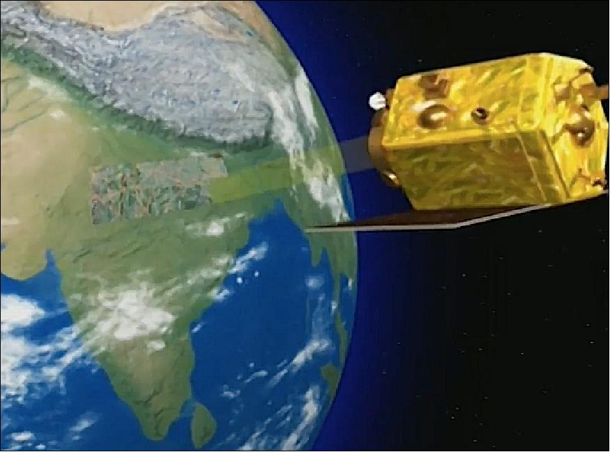
CartoSat-2E
EO
Imaging multi-spectral radiometers (vis/IR)
High resolution optical imagers
Land
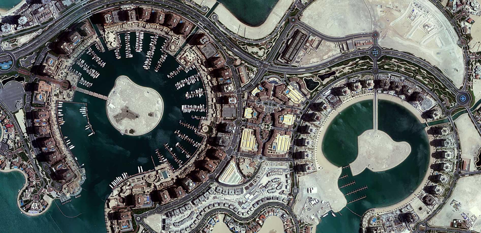
CartoSat-2E is the sixth Earth observation satellite in the CartoSat series, managed by the Indian Space Research Organization (ISRO). The mission is currently operational, having been launched in June 2017 with the objective to collect high-resolution, large-scale imagery to be used in urban planning, infrastructure development, utilities planning and traffic management.
Quick facts
Overview
| Mission type | EO |
| Agency | ISRO |
| Mission status | Operational (nominal) |
| Launch date | 23 Jun 2017 |
| Measurement domain | Land |
| Measurement category | Multi-purpose imagery (land), Vegetation, Albedo and reflectance, Landscape topography |
| Measurement detailed | Land surface imagery, Vegetation type, Earth surface albedo, Land surface topography, Glacier topography |
| Instruments | PAN (Cartosat-2E), HRMX |
| Instrument type | Imaging multi-spectral radiometers (vis/IR), High resolution optical imagers |
| CEOS EO Handbook | See CartoSat-2E summary |
Summary
Mission Capabilities
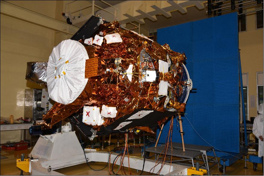
Cartosat-2E is equipped with an imaging payload, comprised of a High-Resolution Multispectral Radiometer (HRMX) and a Panchromatic Camera (PAN), both of which reside in the focal plane of a two-mirror Ritchey-Chretien telescope using CCDs (Charged Coupled Devices). The telescope has an on-axis mirror system, featuring a concave primary mirror and a convex secondary mirror. Its structure is made of the highly thermally stable material CFRP (Carbon-Fiber Reinforced Polymer), which keeps the optical components in alignment.
PAN can be tilted along its track for in-orbit spectroscopy and is capable of taking black and white photographs in certain sections of the visible and near-infrared spectrum, while HRMX, as a four-channel radiometer working in pushbroom mode, is sensitive across the entire visible spectrum and part of the near-infrared spectrum.
This imaging system can support continuous strip imaging and spot scene imaging. Moreover, it can function in paint brush mode, where the spacecraft rolls and pitches in order to deliver strips of adjacent areas, broadening the instantaneous ground swath. The generated imagery features in cartography, environmental monitoring, disaster relief and event monitoring.
Performance Specifications
The mission’s telescope has an aperture diameter of 0.7 m and a focal length of 5.6 m. The CCD detector system covers a spectral range from 450 nm to 900 nm and reaches a ground resolution of 0.65 m when employing apparent velocity reduction for along-track imaging.PAN works in pushbroom mode, imaging with a resolution of 0.65 m in the wavelength interval 0.50 - 0.85 µm, and swathwidth of 9.6 km. HRMX has a 2 m resolution and a 10 km swath width, functioning in the wavelength ranges: 0.43 - 0.52 µm, 0.52 - 0.61 µm, 0.61 - 0.69 µm, 0.76 - 0.90 µm.
Cartosat-2E uses an agile attitude actuation system, capable of completing imaging operations at off-nadir angles up to 45°. This enables the satellite to achieve a four-day revisit time that can be further reduced to one day through orbital manoeuvres.
The spacecraft has an attitude knowledge of ±0.01° and a pointing accuracy of ±0.05°, which translates to a ground accuracy of 100 m. It is steerable by ±45° along the track and ±26° across the track.
CartoSat-2E maintains a sun-synchronous near-circular orbit at an altitude of 505 km and an inclination of 97.44°.
Space and Hardware Components
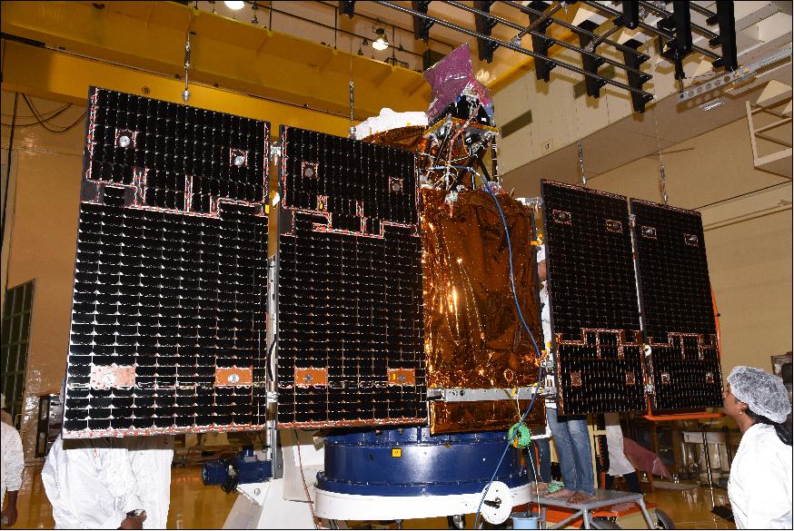
The spacecraft employs a hexagonal CFRP bus structure and achieves three-axis stabilisation through a combination of reaction wheels, magnetorquers and hydrazine-fuelled reaction control thrusters. 968 W of electrical power can be generated by a pair of solar arrays. The energy is then stored inside two Lithium-ion batteries. The satellite is equipped with an eight-channel GPS (Global Positioning System) receiver for the calculation of instantaneous state vectors and orbital parameters. GPS is also used for GEO-referencing of the acquired imaging data. The satellite's Data Handling System (DHS) receives 11-bit data from the CCD video processing unit with a data rate of 336 Mbit/s. A two-way gimballed X-band phased array antenna is used to downlink high-speed data to ground stations at a rate of 105 Mbit/s.
CartoSat-2E weighs 712 kg, with about 2.4 m in diameter and 2.5 m in height. It was designed with a nominal lifespan of five years.
CartoSat-2E satellite
Spacecraft Launch Mission Status Sensor Complement References
CartoSat-2E is the 6th Earth observation satellite of ISRO's (Indian Space Research Organization) CartoSat series. The objective is to collect high-resolution, large-scale imagery for use in urban planning, infrastructure development, utilities planning, and traffic management. The high-resolution panchromatic and multispectral data is vital for effective urban planning through a precise understanding of the changes in the spatial extent of urbanized land areas. Applications of remote sensing and GIS technologies have progressively been expanded to cover agriculture, forestry, ecology, water resources, urban and regional planning, mineral exploration, and utilities planning.
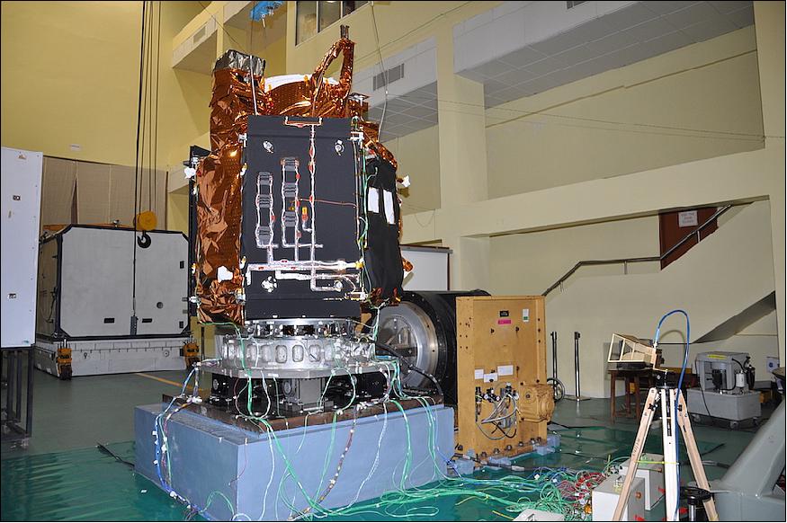
Spacecraft
Designed for Earth observation, CartoSat-2E is the latest in a series of spacecraft which have been used for both military and civilian applications. following on from the civilian Cartosat-2 which was launched in January 2007. 1) 2)
The first dedicated military satellite, CartoSat-2A was launched in April 2008, followed by CartoSat-2B in July 2010. The series' latest three satellites have been deployed over the space of a year and a day – with Cartosat-2C launching on 22 June 2016 and Cartosat-2D on 15 February 2017. All of the constellation's launches have used ISRO's PSLV rocket.
The CartoSat-2E spacecraft is based on ISRO's IRS-2 bus, with a liftoff mass of 712 kg. The spacecraft employs a hexagonal bus structure comprised of a CFRP (Carbon Fiber Reinforced Plastic) structure. The satellite stands approximately 2.5 m tall and is 2.4 m in diameter. It is expected to operate for five years. The spacecraft achieves three-axis stabilization through a combination of reaction wheels, magnetorquers and hydrazine-fuelled reaction control thrusters. Power is generated by a pair of solar arrays, charging two lithium-ion batteries. The solar arrays can generate 986 W of electrical power for the spacecraft.
The four reaction wheels each have a momentum capacity of 15 Nms and a torque capability of 0.3 Nm. Eight monopropellant thrusters are installed on the spacecraft, each delivering a thrust of 1 Newton, fed from a 64 kg hydrazine supply.
Cartosat-2E uses a highly agile attitude actuation system, capable of completing imaging operations at off-nadir angles of up to 45 degrees. With this cross-track imaging capability, one satellite reaches a four-day revisit time that can be reduced to one day by means of orbital maneuvers. During typical mission operations, the satellite will face its two-panel solar arrays toward the sun for power generation unless imaging operations are taking place.
The satellite achieves an attitude knowledge of ±0.01º and a pointing accuracy of ±0.05º. This translates to a ground accuracy of 100 m, suitable for high-precision imaging of locations of interest.
The satellite is outfitted with an eight-channel GPS receiver for the calculation of instantaneous state vectors and orbital parameters. GPS is also used for GEO-referencing of acquired imaging data.
The satellite's Data Handling System receives 11-bit data from the CCD video processing unit with a data rate of 336 Mbit/s and stores processed payload data in a 64 Gbit SSR (Solid State Recorder). A two-way gimballed X-band (8125 MHz) phased array antenna is used to downlink high-speed data to ground stations. Downlink occurs after JPEG compression and encryption of the data at a 105 Mbit/s rate. Telemetry and Command up/downlink uses S-band (2067 MHz) at a data rate of 4 kbit/s.
Launch
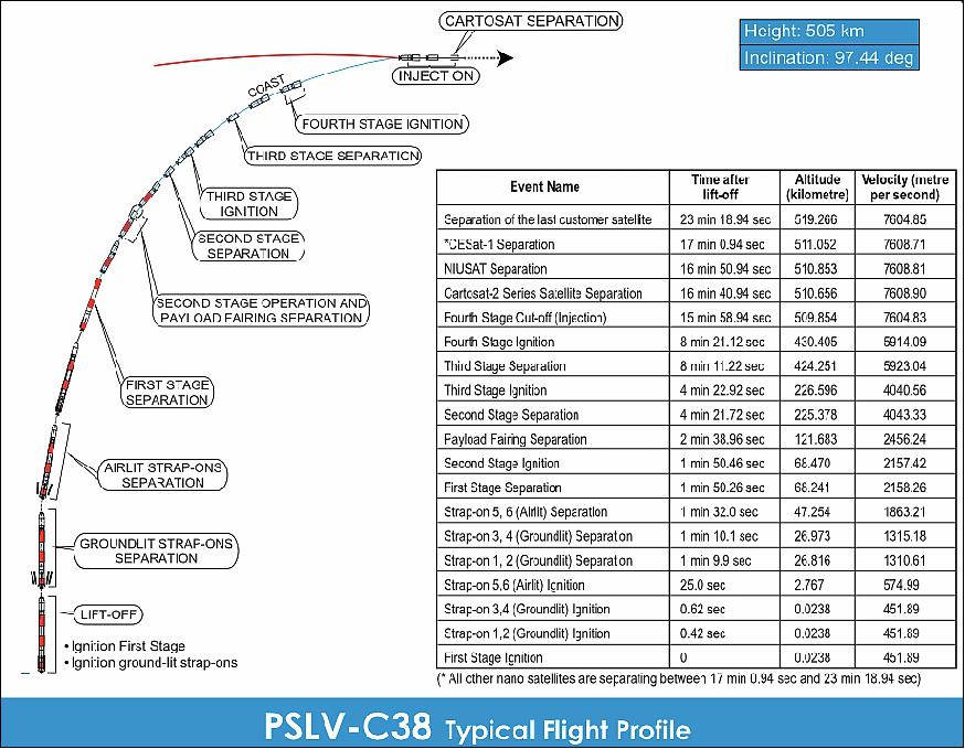
CartoSat-2E was launched on 23 June 2017 (03:59 UTC) along with on the PSLV-C38 vehicle in XL configuration of ISRO from SDSC (Satish Dhawan Space Center), Sriharikota, India. In addition, there were 30 co-passenger satellites onboard. This is the thirty ninth consecutively successful mission of PSLV. CartoSat-2E has a launch mass of 712 kg. The total liftoff mass with co-passengers is 955 kg. 3) 4) 5)
Orbit: Sun-synchronous near-circular orbit, altitude of 505 km, inclination = 97.44º, LTDN (Local Time on Descending Node) at 9:30 hours.
Secondary payloads: 30 satellites (co-passengers) with a total mass of 243 kg)
The 29 international customer nanosatellites were launched as part of the commercial arrangements between Antrix (Antrix Corporation Limited), a Government of India company under DOS (Department of Space) and the commercial arm of ISRO and the International customers.
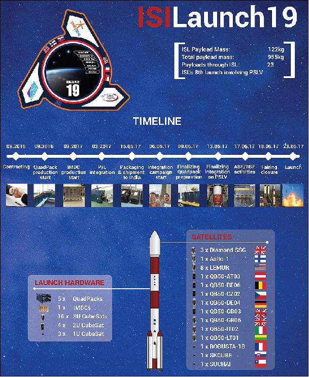
The Dutch company ISISpace (Innovative Solutions In Space) of Delft accommodated most of the secondary payloads aboard the multi-satellite launch (responsible for manifesting a total of 23 satellites on this particular launch). Engineers stowed the CubeSats in QuadPacks before shipping them to the Indian launch site. 7)
Among these 23 satellites, there are 8 CubeSats that will complement and complete the QB50 constellation for upper atmospheric research (www.qb50.eu). This project, sponsored by the European Commision's FP7 is managed by the Von Karmann Institute from Belgium and ISISpace has been one of the consortium partners of QB50 since the start. The CubeSats launched by ISISpace into polar orbit will work together with the CubeSats deployed from the International Space Station in May.
The ISILaunch19 manifest also includes several payloads that were initially scheduled for a launch on a Falcon 9 mission through Spaceflight's Sherpa mission, a launch that was significantly delayed due to various factors. ISL and Spaceflight have jointly worked on re-manifesting these payloads to this PSLV launch to make sure our customer's satellites were launched earlier. Such a re-manifesting of payloads clearly shows the added value of the ISILaunch Services of ISISpace to serve the CubeSat community, offering access-to-space flexibility towards customers of launch services by operating across multiple launch vehicles and missions in parallel.
• NIUSAT (Noorul Islam University Satellite), located in Kumarakovil, Thuckalay, Kanyakumari District Tamil Nadu, India. NIUSAT is an Earth observation nanosatellite (15 kg). NIUSAT features a RGP camera with a ground resolution of 25 m and a frame size of 50 km x 50 km.
• CE-SAT-1 (Canon Electric Satellite-1), a microsatellite (50 kg) of Canon Electronics Space Technology Laboratory, Japan. The microsatellite features an optical imaging system based on a 40 cm diameter Cassegrain telescope.
• Max Valier, a nanosatellite (16 kg) of the "Max Valier" school Bolzano and the "Oskar von Miller" school Merano, in South Tyrol, Italy.
• D-SAT (Deorbit Satellite), a 3U CubeSat mission (3.5 kg) by the Italian company D-Orbit to demonstrate active end-of-life reentry.
• 3 Diamond nanosatellites (Blue, Green, Red) of Sky and Space Global, UK, developed by GomSpace ApS of Denmark. The three 3U CubeSats (each 6 kg) are pathfinders for Sky and Space Global's 200 Satellite LEO constellation.
• Pegasus, a nanosatellite (2U CubeSat) of FH Wiener Neustadt, Austria (thermosphere research). Pegasus is a member of the QB50 constellation with the m-NLP payload.
• InflateSail, a 3U CubeSat of SSC (Surrey Space Centre) at the University of Surrey, UK (technology demonstration nanosatellite). Part of the QB50 constellation. Inflatesail is designed to test a deployable sail as a means to deorbit the satellite. Inflatesail will use a 3.3 m sail at the end of a 1m boom deployed from the body of the satellite.
• UCLSat (University College London Satellite), a 2U CubeSat of UCL with the INMS (Ion and Neutral Mass Spectrometer), ionosphere research. UCLSat is part of the QB50 constellation.
• NUDTSat (National University of Defense Technology Satellite), Belgium, a 2U CubeSat of NUDT for ionosphere research. NUDTSat features a FIPEX instrument of the QB50 constellation.
• COMPASS-2 (DragSail CubeSat), a 3U CubeSat of FH Aachen, Germany (technology demonstration nanosatellite). COMPASS-2 is part of the QB50 constellation.
• LituanicaSAT-2, a 3U CubeSat of Vilnius University, Lithuania. The CubeSat is part of the QB50 constellation with a FIPEX payload.
• URSA MAIOR (University of Rome la SApienza MicroAttitude In ORbit testing), a 3U CubeSat to study the lower thermosphere. USRA MAIOR is a member of the QB50 constellation with the m-NLP payload.
• VZLUSat-1, a 2U CubeSat Czech technology nanosatellite of VTLU, developed in cooperation with Czech companies (RITE, HVP Plasma, 5M, TTS, IST) and universities (CVUT, University of West Bohemia). The nanosatellite carries on board the following experiments: a miniaturized X-ray telescope, composite material for radiation shielding, FIPEX, a QB50 instrument, to measure the concentration of oxygen in the thermosphere.
• SUCHAI-1 (Satellite of the University of Chile for Aerospace Investigation), a 1U CubeSat (1 kg).
• Venta-1, a nanosatellite (7.5 kg) of Ventspils University, Latvia, developed by Ventspils University College in cooperation with Ventspils High Technology Park, Bremen University of Applied Sciences and OHB Systems. Venta-1 carries an AIS (Automated Identification System ) receiver, which will pick up identification signals from ships at sea.
• Aalto-1, a Finnish student nanosatellite (3U CubeSat) of Aalto University, Aalto, Finland.
• ROBUSTA-1B (Radiation on Bipolar Test for University Satellite Application), a nanosatellite with a scientific experiment developed by the University of Montpellier students (France), a successor to the ROBUSTA satellite, which was launched in February 2012.
• skCube, a 1U CubeSat for educational and popularization outreach developed by SOSA (Slovak Organization for Space Activities ) at the University of Zilina. It is Slovakia's first satellite.
• CICERO-6 (Community Initiative for Cellular Earth Remote Observation-6), a 6U CubeSat of GeoOptics Inc. (~10 kg), Pasadena, CA, built by Tyvak Nanosatellite Systems. The objective is to demonstrate radio occultation observations for a commercial customer. CICERO-6 features Cion (CICERO Instrument for GPS-RO) with a mass of 1.2 kg. Cion has a size of 30 x 10 x 6 cm, power of 8 W. 8)
• Tyvak-53b, a technology 3U demonstrator by Tyvak Nanosatellite Systems, Inc. (Irvine, CA) to validate technology aimed at helping to deorbit small satellites.
• Lemur-2 x 8. Lemur-2 is commercial satellite constellation of Spire Global Inc., San Francisco, CA, The objective of the Lemur-2 constellation is ship tracking via AIS (Automatic Identification System) with SENSE. The STRATOS instrument makes use of GPS occultation measurements to determine temperature, pressure and humidity profiles of Earth's atmosphere for application in operational meteorology.
Note: Several of the 31 satellites launched on PSLV-C38 were rebooked earlier this year from a long-delayed SpaceX Falcon-9 launch from California. Seattle-based Spaceflight, a company that arranges rideshare missions for small satellite owners, planned to send up 89 payloads on a secondary payload adapter called Sherpa aboard a Falcon-9 flight shared with Formosat-5, a Taiwanese Earth observation spacecraft. 9)
When it initially disclosed plans to launch the first Sherpa deployer on a Falcon-9, Spaceflight said the flight was scheduled for 2014.
Mission Status
• June 23, 2017: After a flight of about 16 minutes, the satellites achieved a polar SSO (Sun Synchronous Orbit) of 505 km inclined at an angle of 97.44 degree to the equator (very close to the intended orbit) and in the succeeding seven and a half minutes, all the 31 satellites successfully separated from the PSLV in a predetermined sequence beginning with Cartosat-2 series satellite, followed by NIUSAT and 29 customer satellites. The total number of Indian satellites launched by PSLV now stands at 48 (Ref. 3).
- After separation, the two solar arrays of Cartosat-2 series satellite were deployed automatically and ISTRAC (ISRO's Telemetry, Tracking and Command Network) at Bangalore took over the control of the satellite. In the coming days, the CartoSat-2E satellite will be brought to its final operational configuration following which it will begin to provide various remote sensing services using its panchromatic (black and white) and multispectral (color) cameras.
- One of the 30 co-passenger satellites carried by PSLV-C38 was the 15 kg NIUSAT, a University/Academic Institute satellite from Nurul Islam University, Tamil Nadu, India. The remaining 29 co-passenger satellites carried were international customer satellites from USA (10), United Kingdom (3), Belgium (3), Italy (3), Austria (1), Chile (1), Czech Republic (1), Finland (1), France (1), Germany (1), Japan (1), Latvia (1), Lithuania (1) and Slovakia (1).
Sensor Complement
Cartosat-2E is the third in the series to host a Multispectral imaging system in addition to the Panchromatic imager. The 120 kg payload is comprised of a two-mirror Ritchey-Chretien telescope with an on-axis mirror system featuring a concave primary mirror and a convex secondary mirror. The mirrors are made from Zerodur and the telescope structure consists of CFRP (Carbon-Fiber Reinforced Polymer) due to the material's excellent thermal stability, keeping the optical components in alignment. The telescope has an aperture diameter of 70 cm and a focal length of 5.6 m. 10)
In the focal plane resides a panchromatic and multispectral detection system using CCDs (Charged Coupled Devices) with 7 µm pixels. The detector system covers a spectral range of 450 to 900 nm and reaches a ground resolution of 65 cm when employing apparent velocity reduction for along-track imaging. Four MX detectors with bandpass filters between 450 and 860 nm deliver imagery at a2 m ground resolution along a 10 km swath.
The imaging payload can support continuous strip imaging, spot scene imaging and paint brush mode in which roll and pitch of the spacecraft are used to deliver strips of adjacent areas in order to broaden the instantaneous ground swath.
The main purpose of the Cartosat-2 satellite series is the generation of imagery for cartography, environmental monitoring, disaster relief and event monitoring.
PAN (Panchromatic Camera)
PAN is capable of taking panchromatic (black and white) photographs in a selected portion of the visible and near-infrared spectrum (0.50–0.85 µm) at a resolution of 65 cm.
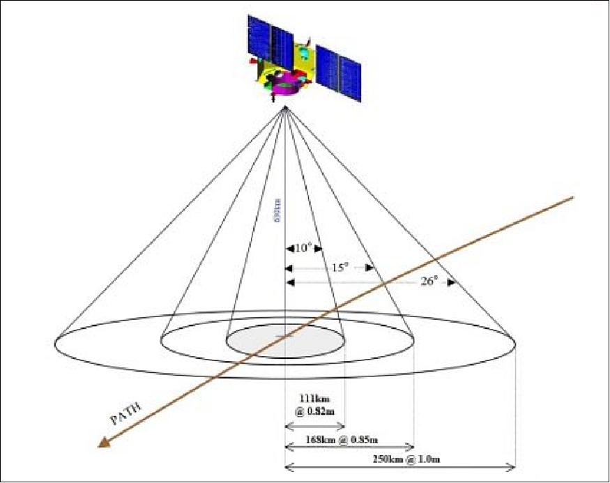
Pushbroom, 12288 pixel/line, swath 9.6 km. Possible to be tilted along-track (10° aft- and 26° fore-) for in-orbit stereoscopy, and cross-track within a field of regard of 400 km.
The PAN instrument has a mass of 120 kg, a power consumption of 60 W and a data rate of 336 Mbit/s.
HRMX (High-Resolution Multispectral Radiometer)
HRMX is a four-channel radiometer sensitive across the entire visible spectrum and part of the near-infrared spectrum (0.43–0.90 µm) at a resolution of 2 meters.
4-channel VIS/NIR radiometer: 0.43 - 0.52 µm , 0.52 - 0.61 µm, 0.61 - 0.69 µm, 0.76 - 0.90 µm
Consolidated technology, associated to a panchromatic camera (PAN)
HRMX is a pushbroom radiometer, 10 km swath, steerable within a FoR (Field of Regard) of 400 km and along-track fore- and aft-
Depending on pointing strategy. Repeat cycle for a selected local scene: one week minimum, in daylight.
References
1) William Graham, "PSLV rocket launches Cartosat 2E and 30 small sats," NASA Spaceflight.com, June 22,2017, URL: https://www.nasaspaceflight.com/2017/06/pslv-rocket-cartosat-2e-30-small-sats/
2) Stephen Clark, "Photos: India's Polar Satellite Launch Vehicle prepared for liftoff," Spaceflight Now, June 22, 2017, URL: https://spaceflightnow.com/2017/06/22/photos-indias-polar-satellite-launch-vehicle-prepared-for-liftoff/
3) "PSLV-C38 Successfully Launches 31 Satellites in a Single Flight," ISRO, June 23, 2017, URL: http://misgovern/update/23-jun-2017/pslv-c38-successfully-launches-31-satellites-single-flight
4) "PSLV-C38 / Cartosat-2 Series Satellite," ISRO, June 23, 2017, URL: http://www.isro.gov.in/launcher/pslv-c38-cartosat-2-series-satellite
5) "Indian Launch Manifest of April 15, 2017," URL: http://www.sworld.com.au/steven/space/india-man.txt
6) Stephen Clark, "Indian rocket set to launch 31 satellites," June 22, 2017, URL: https://spaceflightnow.com/2017/06/22/indian-rocket-set-to-launch-31-satellites/
7) Andra, "Successful ISILaunch19 campaign," ISILaunch19, June 23, 2017, URL: http://blog.isilaunch.com/successful-isilaunch19-campaign/
8) Dave Williamson, "Small Satellites: The Execution and Launch of a GPS Radio Occultation Instrument in a 6U Nanosatellite," 33rd Space Symposium, Colorado Springs, CO, USA, April 3-6, 2017, URL of presentation: https://www.spacesymposium.org/wp-content/uploads/2017/10/Williamson_Dave_GPS_Radio_Occultation_Talk-v1.pdf
9) Stephen Clark, "40th flight of India's PSLV declared a success," Spaceflight Now, June 23, 2017, URL: https://spaceflightnow.com/2017/06/23/40th-flight-of-indias-pslv-declared-a-success/
10) "CartoSat-2E," Spaceflight 101, June 2017, URL: https://spaceflight101.com/pslv-c38/cartosat-2e/
The information compiled and edited in this article was provided by Herbert J. Kramer from his documentation of: "Observation of the Earth and Its Environment: Survey of Missions and Sensors" (Springer Verlag) as well as many other sources after the publication of the 4th edition in 2002. - Comments and corrections to this article are always welcome for further updates (eoportal@symbios.space).
Spacecraft Launch Mission Status Sensor Complement References Back to top