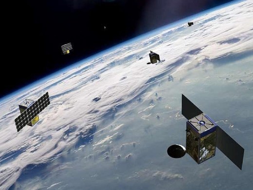
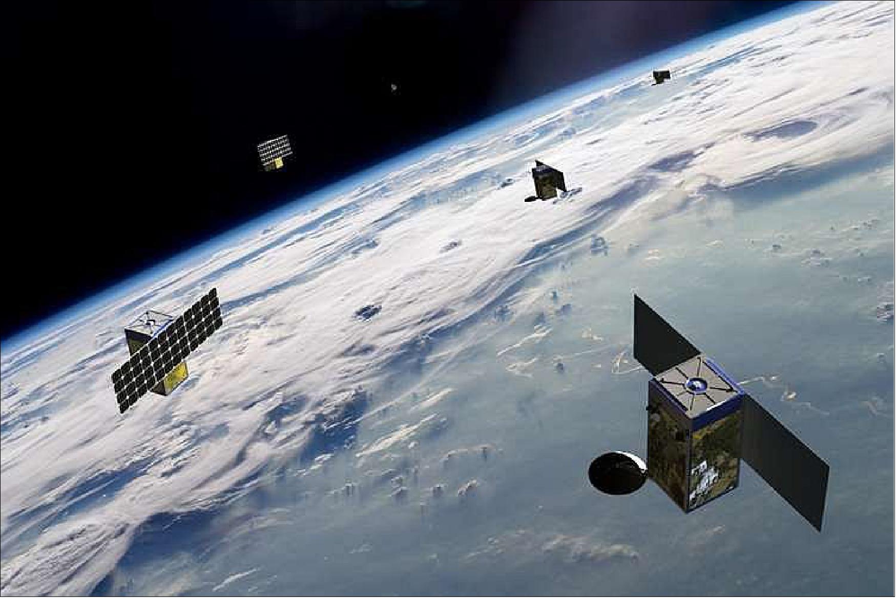
BlackSky Constellation
EO
High resolution optical imagers
Land
Multi-purpose imagery (land)
BlackSky Constellation is a commercially owned and operated constellation of 60 high resolution imaging microsatellites developed by BlackSky Global, formerly a subsidiary of Spaceflight Industries. The constellation aims to provide higher temporal resolution and lower cost Earth imaging, and currently contains 19 operational microsatellites, each with an expected lifetime of 4 years.
Quick facts
Overview
| Mission type | EO |
| Agency | BlackSky |
| Mission status | Operational (nominal) |
| Launch date | 26 Sep 2016 |
| Measurement domain | Land |
| Measurement category | Multi-purpose imagery (land) |
| Measurement detailed | Land surface imagery |
| Instruments | SV-24 |
| Instrument type | High resolution optical imagers |
| CEOS EO Handbook | See BlackSky Constellation summary |
Summary
Mission Capabilities
Each BlackSky Constellation microsatellite carries an identical SV-24 (Spaceview-24™) imaging telescope. The SV-24 sensor has the sole goal of providing high spatial resolution imaging with a variety of applications in commercial and business analysis, natural disaster monitoring and the use of high spatial and temporal resolution imaging to complement alternative methods of data collection.
Performance Specifications
The SV-24 imager has a spatial resolution of 1 m at an altitude of 500 km, with an aperture of 0.24 m and frames of 30 km2. The imager operates in 4 channels, with 3 visible (RGB), and one panchromatic. The BlackSky Constellation microsatellites will be launched into drifting orbits of altitude of approximately 430 km, inclination 42° and periods of 90.00 min.
Space and Hardware Components
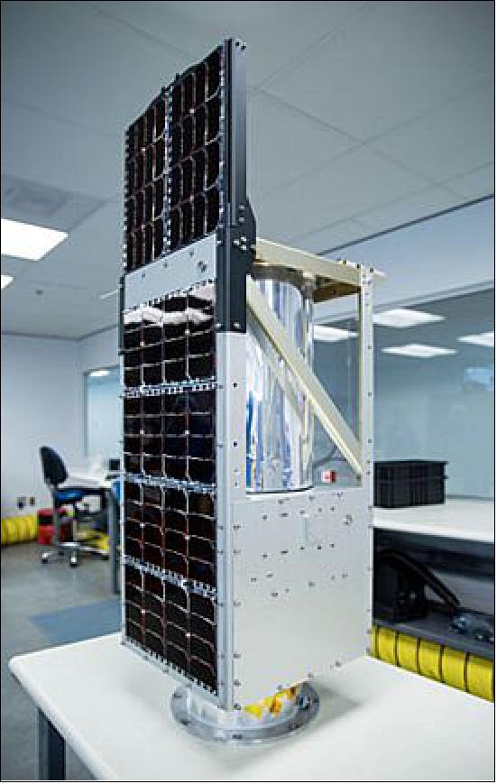
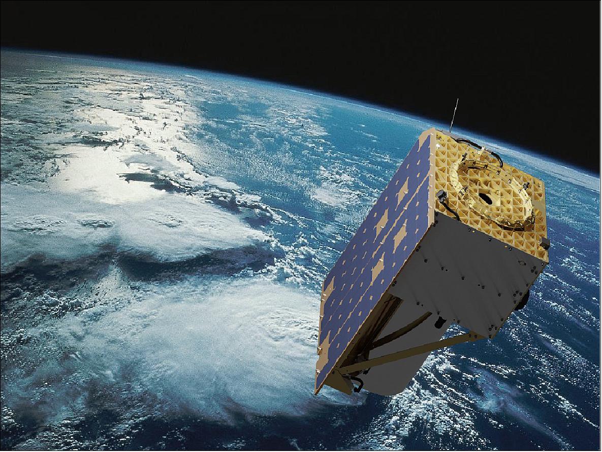
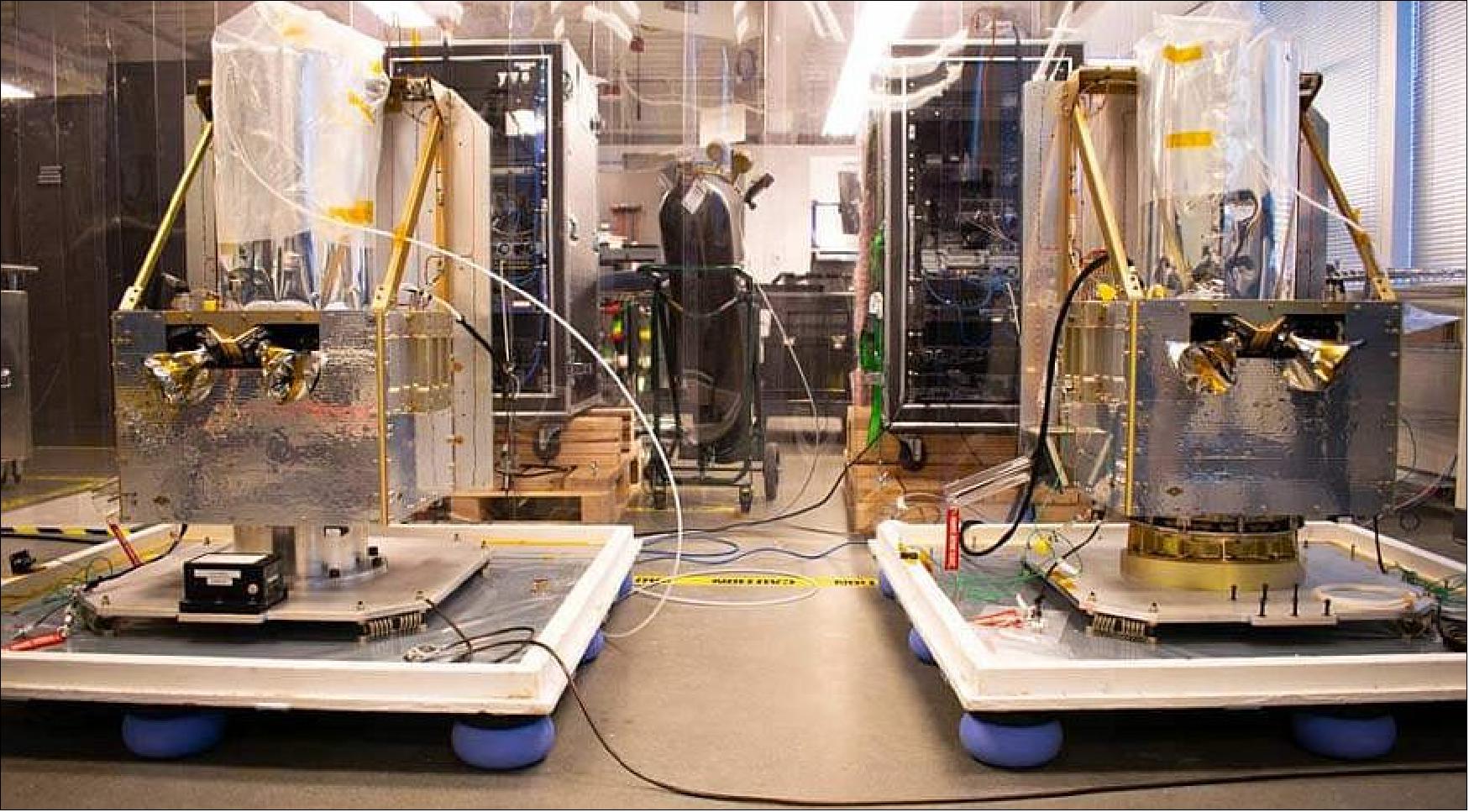
The BlackSky microsatellite buses have been developed and constructed by Spaceflight Industries and are based on existing designs for the SENTRY-4000 bus, which has dimensions 0.4 x 0.46 x 0.84 m. Each microsatellite has a mass of 56 kg and is equipped with a propulsion system for orbit maintenance.
BlackSky Global Commercial Imaging Constellation
Spacecraft Launch Mission Status Sensor Complement References
BlackSky Global (BSG) of Seattle, WA, USA, a startup company founded in 2013, plans to launch a constellation of 60 Earth observation satellites to enable revisit times of a few hours or less. The company has already raised capital to fully fund its first six spacecraft, which are planned for launch in 2016 and will pave the way for the rest of the fleet (with initial operating capability in 2017). BlackSky Global is a new “satellite imaging as a service” provider aimed at commercializing access to high-performance satellite imagery. BlackSky is an independent company owned by Seattle’s Spaceflight Industries, which specializes in launching small satellites as secondary payloads.
The first two satellites, Pathfinder 1 and Pathfinder 2, are in the process of final testing and checkout. They will precede the rest of the constellation as experimental satellites. After the first two satellites, BlackSky Global plans to launch the four additional funded satellites, which would start generating revenue by the end of 2016. 1) 2) 3)
By 2019, BlackSky Global aims to have its full constellation in orbit, providing 1meter resolution color imagery of the planet to a myriad of different customers. The satellites would be able to provide video as well at a speed of one frame per second, and the company is also planning to offer premium services. BlackSky Global has satellite imagery providers and data analytics companies as customers today, and uses a pay-per-picture business model for service from its satellites.
BlackSky Global’s satellites are designed for a three-year mission life at a fairly low altitude of 450 km. The spacecraft will include propulsion systems to reach this service life at such an orbit. The satellites are designed with pre-planned obsolescence in mind, as the lifespan of each spacecraft offers enough time to provide services and then rapidly refresh with new technology.
In June 2015, BlackSky Global revealed its content partnership with commercial imagery intelligence provider AllSource Analysis of Longmont, CO. BlackSky will provide high-resolution, rapid-revisit, cost-effective satellite imaging data to AllSource for incorporation into its multisource analytics capabilities and product development. The partnership will support a variety of analyses across multiple industries such as agriculture, forestry, civil government, non-governmental organizations, defense, finance, engineering, energy and others. Governments and organizations can leverage the combined imagery and analytics capabilities to monitor the worldwide economy, environment and trends to gain valuable business insights and intelligence. 4)
In May 2016, BlackSky announced that it has established an official partnership with UNITAR (United Nations Institute for Training and Research). UNITAR, created in 1965, is an autonomous body within the United Nations that was formed to develop capacities to enhance global decision-making and support country-level action for shaping a better future. "With BlackSky's constellation, we not only have access to more information, but we also have access to it much faster than ever before," said Nikhil Seth, United Nations Assistant Secretary-General, and Executive Director of UNITAR. 5)
About BlackSky Technology Inc.
- BlackSky is a leading provider of real-time geospatial intelligence. Leveraging its own satellite constellation and harnessing the world’s emerging sensor network, the Company monitors the activities and locations worldwide that matter most to its customers. BlackSky’s on-demand constellation of proprietary satellites, together with the sensors in its partners’ constellations, are capable of imaging targeted locations on Earth multiple times a day in a variety of conditions. The data collected from BlackSky’s satellites and other sources populates BlackSky’s proprietary data lake and platform. Cutting-edge computer techniques, including machine learning and artificial intelligence, allow BlackSky’s customers to derive unique and commercially valuable insights, providing them with a first-to-know advantage. BlackSky’s suite of real-time geospatial intelligence products can be integrated into a customer’s system or made available through BlackSky’s Spectra platform using a laptop and internet connection. The Company’s variety of pricing and utilization options enables customers to customize their first-to-know experience.
Spacecraft
The BlackSky-1 pathfinder microsatellite was built by Spaceflight Industries (Spaceflight) of Seattle, WA, USA. The objective of BlackSky-1 Pathfinder mission is to validate the imaging system and data processing chain.
According to BlackSky, the spacecraft of the constellation will be launched into orbits of about 450 km to achieve high-resolution imagery of 1 m GSD (Ground Sample Distance). The microsatellites have a mass of about 44 kg, they will be equipped with a propulsion system to stay in orbit for about 3 years.
A spacecraft description will be provided when the information becomes available.
BlackSky Development Status
• June 21, 2022: BlackSky Technologies Inc. (NYSE: BKSY) was awarded a basic order agreement from the Joint Artificial Intelligence Center (JAIC) to create and optimize data sets for use in DoD AI models and applications. The JAIC agreement has a ceiling value of $241 million over five years. 6)
- “With demonstrated AI expertise in space-based dynamic monitoring, this agreement will open even more doors for BlackSky to contribute its unique value to the diverse national security challenges faced by the wider DoD community,” said Patrick O’Neil, BlackSky chief innovation officer.
- “From automatically tasking satellites to the low-latency delivery and analysis of high-frequency geospatial imagery and non-imagery data, our unique, data-rich platform brings a strong source of core AI-enabled end-to-end capabilities to the DoD’s mission sets,” said O’Neil.
- The JAIC, Defense Digital Service, and Office of Advancing Analytics were merged into a single organization called the Office of the Chief Digital and Artificial Intelligence Officer.
About BlackSky
- BlackSky is a leading provider of real-time geospatial intelligence. BlackSky delivers on-demand, high frequency imagery, monitoring and analytics of the most critical and strategic locations, economic assets, and events on Earth.
- BlackSky designs, owns and operates one of the industry’s leading low earth orbit small satellite constellations, optimized to capture imagery cost-efficiently where and when our customers need it. BlackSky's Spectra AI software platform processes data from BlackSky's constellation and from other third-party sensors to develop the critical insights and analytics that our customers require.
- BlackSky is relied upon by U.S. and international government agencies, commercial businesses, and organizations around the world. BlackSky is headquartered in Herndon, VA, and is publicly traded on the New York Stock Exchange as BKSY.
• April 7, 2022: Amid a surge in demand for satellite imagery, BlackSky is looking to expand its national security and defense business, CEO Brian O’Toole told SpaceNews. 7)
- “The Defense Department is interested in tactical ISR [intelligence, surveillance and reconnaissance] from space,” he said. “There’s quite a bit of opportunity there. ISR is clearly becoming a priority and commercial capabilities have a role to play.”

- The U.S. government is seeing the benefits of commercial capabilities for high-resolution and frequent revisit imagery, he said. It also is realizing that “there are only a few of us that can do what we’re doing right now.”
- “We’re demonstrating that it’s easy for any one of our partners to log into our platform, they can point and click and task a satellite, and get an image back in 90 minutes with analytics,” said O’Toole.
- To help grow its defense and intelligence business, BlackSky on April 4 announced it has formed a strategic advisory group led by former undersecretary of defense for intelligence and retired Navy vice admiral Joseph Kernan, former associate director for military affairs at the CIA and retired Army general John Mulholland, and former Space Force chief architect, retired Air Force colonel Michael Dickey.
- BlackSky last October tapped former principal deputy director of national intelligence Sue Gordon to serve on its board of directors.
- The company recently added two more satellites to its constellation, for a total of 14. Rocket Lab’s Electron rocket on April 2 launched the two satellites from New Zealand.
- O’Toole said he expects BlackSky to be one of the companies selected by the National Reconnaissance Office as primary providers of commercial imagery for the U.S. intelligence community. The NRO this year will select providers for its Electro-Optical Commercial Layer contract.
- “We also have efforts going on with the Army and the Space Force and others,” he said. Some military organizations are interested in services that combine traditional imagery collection with on-demand satellite tasking.
- BlackSky’s constellation will remain at 14 for now, although there are a couple more launches planned for later this year with Rocket Lab.
- Current satellites have less than one-meter resolution. Next year BlackSky plans to start launching a new generation that will bring the imaging resolution down to 35 cm at nadir – looking straight down – and 50 cm on average, said O’Toole. These satellite also will have infrared sensors, inter-satellite links and on-board data processing enabled by artificial intelligence.
Market Challenges
- BlackSky in September became a publicly traded company after closing a merger with a special purpose acquisition company, or SPAC. BlackSky and other space companies that went public over the past year through mergers with SPACs have suffered sharp declines in share prices and thus their valuations.
- O’Toole insisted the SPAC deal benefited BlackSky because it provided the capital to fund its next-generation satellites and other projects. “And it’s also given us the growth capital to expand our sales force and our product teams.”
- He said the SPAC method for taking a company public is “well suited for companies like ours.”
- Markets have soured on SPACs in general but not all companies are equal, he said. “We happen to be a company that had revenue and customers. There were a lot of SPACs that were very much early stage. We’ve been caught up in that but it’s accomplishing what we wanted.”
• November 12, 2021: U.S. government contracts are boosting the financial performance of Earth observation company BlackSky, executives said Nov. 12 during the company’s first earnings call since going public. 8)
- BlackSky released its third-quarter financial results, showing a revenue jump of $7.9 million, up 49% from a year ago. The company generated an operating loss of $48.9 million in the third quarter, up from a loss of $12.5 million in the prior year period. It ended the third quarter with $198 million of cash on its balance sheet.
- The satellite imagery and geospatial data provider began trading on the NYSE in September after closing a SPAC merger with a special purpose acquisition company.
- CEO Brian O’Toole said during the earnings call that BlackSky is revising its 2021 revenue forecast from $40 million to a range of $30 to $34 million. This is “primarily driven by the timing of new contract start dates and supply chain impacts due to the COVID-19 pandemic.”
- O’Toole announced a new contract award from NASA, a five-year, sole source blanket purchase agreement to provide high revisit satellite imagery in support of NASA’s Earth observation research.
- “This gives NASA the ability to buy imagery from us on an annual basis at the scale of multiple millions of dollars per year,” O’Toole said. “They’ve been increasing their interest in commercial imagery and analytics for climate change and other research.”
- The company is pursuing new commercial business in the mining, financial and transportation sectors. But BlackSky’s main customers are U.S. government agencies, particularly defense and intelligence. “We are winning and extending multi-year contracts, which strengthens our visibility into out-year revenues,” said O’Toole.
- The National Reconnaissance Office (NRO) extended an existing contract, he said. “Imagery deliveries under the contract increased 100% from the second quarter to the third quarter.”
- The company also won a $30 million, five-year indefinite delivery indefinite quantity contract with the National Geospatial-Intelligence Agency (NGA) for artificial intelligence enabled economic monitoring, and signed a strategic commercial agreement with Palantir Technologies to support Palantir’s government customers.
- BlackSky is competing for an NRO contract under the Electro-Optical Commercial Layer procurement, with proposals due in early December and awards expected in spring 2022.
- O’Toole said the company is looking to expand its constellation of imaging satellites from six currently to 12 by year’s end, pending the timing of planned launches from Rocket Lab’s pad in New Zealand. Two BlackSky satellites are scheduled to fly next week on Rocket Lab’s Electron vehicle. Two BlackSky satellites were lost earlier this year in a launch failure.
• September 9, 2021: BlackSky Holdings, Inc. (“BlackSky”), a leading technology platform providing real-time geospatial intelligence and global monitoring, today announced it has completed its previously announced business combination with Osprey Technology Acquisition Corp. (“Osprey”) to take BlackSky public. The combined company has been renamed “BlackSky Technology Inc.” and its shares will commence trading on the New York Stock Exchange (NYSE) on September 10, 2021, under the ticker symbol “BKSY” for BlackSky common stock and “BKSY.W” for BlackSky warrants. 9)
- Upon closing, the combined company received approximately $283 million in gross proceeds, comprised of approximately $103 million in cash held in trust by Osprey and the proceeds of a $180 million PIPE. Osprey’s shareholders approved the transaction at a shareholder meeting on September 8, 2021.
- “Our team is excited that we have reached this major milestone on our first-to-know mission to lead a new era of real-time global intelligence. We are looking forward to this next chapter as a public company and the many opportunities that lie ahead in the new space economy,” said BlackSky CEO Brian O’Toole. “We welcome our new shareholders to join our journey as we provide global customers with critical insights to see and understand important changes that impact their business.”
- As a public company, BlackSky’s position as a leading geospatial data, analytics and monitoring services company is further strengthened. CEO Brian O’Toole will continue to lead the combined company with Will Porteous remaining as chairman of the board. In connection with the business combination, Magid Abraham, Timothy Harvey and James Tolonen will join BlackSky’s board. David DiDomenico, a partner at JANA Partners who heads its SPAC initiative and, in such role, serves as president, CEO and a director of Osprey, will continue to serve on the combined company’s board of directors.
- “The Osprey team is very excited for Brian O’Toole and the BlackSky organization. We look forward to watching them execute on BlackSky’s strategic growth plan as a public company,” said Osprey Co-Executive Chairman Jonathan Z. Cohen.
- To memorialize the completion of the business combination, BlackSky will be ringing the opening bell at the NYSE at 9:30 a.m. EDT on September 13, 2021.
• April 20, 2018: DSI (Deep Space Industries), headquartered in Silicon Valley, California, announced that it has signed a contract with Astro Digital to provide several CometTM water-based satellite propulsion systems. Comet is a simple, launch-safe, and cost-effective electrothermal propulsion system that uses water as a propellant and can be customized for nearly any small satellite application. 10)
- “We chose DSI’s propulsion solution because of the team’s ability to deliver a unique and relatively large microsat propulsion system on an incredibly aggressive schedule,” explained Chris Biddy, chief executive officer of Astro Digital. “We are quite impressed by the Comet’s scalable nature and ease of integration.”
- Comet is unique in that it uses water as propellant. This is especially important for Deep Space Industries’ future asteroid mining plans, as water will be among the first resources mined from asteroids. In the meantime, this propulsion system is efficient, affordable, and easy to use for small satellites that will stay much closer to home, for customers such as Astro Digital.
- “Astro Digital is a fantastic organization. We are proud to partner with their team on this and many other projects in the future, “commented Bill Miller, chief executive officer of Deep Space Industries. “Comet has been very successful in the market and we are adding new customers almost monthly at this point.”

This announcement comes on the heels of Spaceflight Industries’ recent $150 million funding and the development of LeoStella LLC, a joint venture between Spaceflight Industries and Thales Alenia Space. LeoStella is developing a Seattle-based facility to manufacture the low-cost, high-performance BlackSky satellites and is tasked with building the next 20 spacecraft with the Comet propulsion technology between now and 2020.
These smallsats are part of an ultimate constellation of 60 satellites that provide high revisit rate Earth imagery and when combined with other space and terrestrial based sensors, will enable delivery of innovative global monitoring solutions and geospatial activity-based intelligence services.
Launch
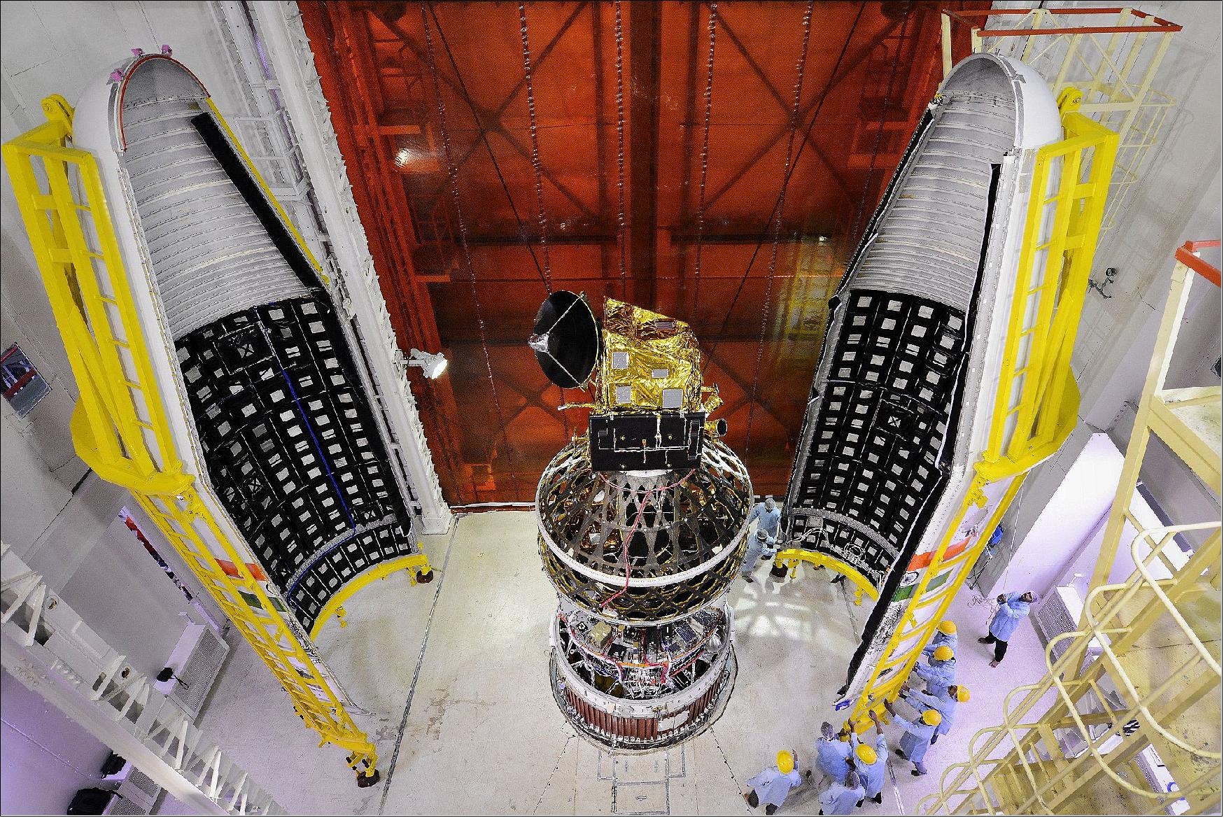
Launch: The BlackSky-1 pathfinder microsatellite was launched as a secondary payload on Sept. 26, 2016 (03:42:00 UTC) on the PSLV-C35 vehicle of ISRO. The launch site was SDSC (Satish Dhawan Space Center) on the east coast of India. The primary payload on this flight was SCATSat-1(Scatterometer Satellite-1) of ISRO. 12) 13) 14)
Orbit: Sun-synchronous orbit of SCATSat-1, altitude = 720 km, inclination = 98.1º, LTAN = 9:20 hours.
All secondary payloads were deployed into an orbit of 670 km altitude.
This was ISRO's first multi-orbit mission. It was the longest ever PSLV flight which lasted for more than 2 hours 15 minutes. According to ISRO, PSLV-C35 successfully placed all satellites into their respective orbits.
• Pratham, a student-built nanosatellite (~10 kg) of IIT (Indian Institute of Technology) Bombay, India to study the ionosphere.
• PISAT, a student-built nanosatellite (5.3 kg) of PES University in Bengaluru, India. PISAT is a joint initiative of PES University and five other colleges. 15)
• BlackSky Pathfinder-1, a high-resolution (1 m) imaging microsatellite (~44 kg) of BlackSky Global. BlackSky Global is a commercial company of Seattle, WA, USA. The goal of BlackSky Global is to build a constellation of 60 satellites by 2019.
• AlSat-1N, AlSat-1B and AlSat-2B of ASAL (Algerian Space Agency), Algiers, Algeria. The three satellites were manufactured at SSTL partnership with Algerian engineers, ALSAT-1B is a 103 kg microsatellite based on the SSTL-100 bus. It carries an Earth imaging payload with panchromatic and multispectral cameras. AlSat-2B (117 kg) carries the NAOMI (New AstroSat Optical Modular Instrument). AlSat-1N (AlSat-Nano) is a 3U CubeSat which carries a technology demonstration payload as part of a partnership between ASAL and the UKSA (UK Space Agency).
• CanX-7, a nanosatellite (3U CubeSat, 8 kg) of UTIAS/SFL (University of Toronto’s Institute of Aerospace Studies/Space Flight Laboratory), Canada.
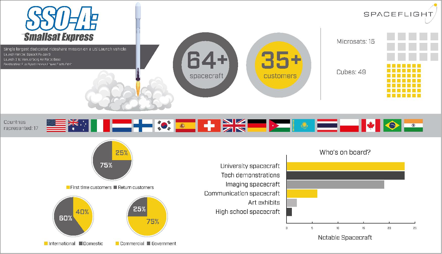
Launch: The BlackSky-2 microsatellite (56 kg) of BlackSky Global was launched on the rideshare mission of Spaceflight Industries (Seattle, WA) on 3 December 2018 (18:34 GMT) on a SpaceX Falcon-9 Block 5 vehicle from VAFB (Vandenberg Air Force Base) in California. 16) 17)
SpaceX statement: On Monday, December 3rd at 10:34 a.m. PST (18:34 GMT), SpaceX successfully launched Spaceflight SSO-A: SmallSat Express to a low Earth orbit from Space Launch Complex 4E (SLC-4E) at Vandenberg Air Force Base, California. Carrying 64 payloads, this mission represented the largest single rideshare mission from a U.S.-based launch vehicle to date. A series of six deployments occurred approximately 13 to 43 minutes after liftoff, after which Spaceflight began to command its own deployment sequences. Spaceflight’s deployments are expected to occur over a period of six hours. 18)
This mission also served as the first time SpaceX launched the same booster a third time. Falcon 9’s first stage for the Spaceflight SSO-A: SmallSat Express mission previously supported the Bangabandhu Satellite-1 mission in May 2018 and the Merah Putih mission in August 2018. Following stage separation, SpaceX landed Falcon 9’s first stage on the “Just Read the Instructions” droneship, which was stationed in the Pacific Ocean.
Orbit: Sun-synchronous circular orbit with an altitude of 575 km, inclination of ~98º, LTDN (Local Time of Descending Node) of 10:30 hours.
List of payloads on the Spaceflight SSO-A rideshare mission
The layout of the list follows the alphabetical order of missions as presented on the Wikipedia page ”2018 in spaceflight” https://en.wikipedia.org/wiki/2018_in_spaceflight#November — as well as with the help of Gunter Krebs's short descriptions at https://space.skyrocket.de/doc_sdat/skysat-3.htm
This mission enabled 34 organizations from 17 different countries to place spacecraft on orbit. It’s also special because it was completely dedicated to smallsats. Spaceflight launched 15 microsatellite and 49 CubeSats from government and commercial entities including universities, startups, and even a middle school. The payloads vary from technology demonstrations and imaging satellites to educational research endeavors.
• AISTechSat-2, a 6U CubeSat for Earth observation of AISTech (Access to Intelligent Space Technologies), Barcelona, Spain.
• Al Farabi-2, a 3U CubeSat technology demonstration mission of the Al-Farabi Kazakh National University, Kazakhstan.
• Astrocast-0.1, a 3U CubeSat technology demonstration mission of Astrocast, Switzerland, dedicated to the Internet of Things (IoT)
• Audacy-0, a 3U CubeSat technology demonstration mission of Audacy, Mountain View, CA, built by Clyde Space.
• BlackSky-2, a microsatellite (56 kg) of BlackSky Global (Seattle, WA) which will provide 1 m resolution imagery with improved geolocation accuracy.
• BRIO, a 3U CubeSat of SpaceQuest Ltd. of Fairfax, VA to test a novel communications protocol that uses SDR (Software Defined Radio).
• Capella-1, a microsatellite (37 kg) of Capella Space, San Francisco, CA featuring a X-band SAR (Synthetic Aperture) payload.
• Centauri-1, a 3U CubeSat of Fleet Space Technologies, Adelaide, South Australia. Demonstration of IoT technologies.
• CSIM-FD (Compact Spectral Irradiance Monitor-Flight Demonstration), a 6U CubeSat of LASP (Laboratory for Atmospheric and Space Physics) at the University of Boulder, CO, USA. The goal is to measure solar spectral irradiance to understand how solar variability impacts the Earth’s climate and to validate climate model sensitivity to spectrally varying solar forcing.
• Eaglet-1, the first 3U CubeSat (5 kg) of OHB Italia SpA for Earth Observation.
• Elysium Star-2, a 1U CubeSat of Elysium Space providing space burial services.
• ESEO (European Student Earth Orbiter) sponsored by ESA, a microsatellite of ~40 kg with 6 instruments aboard.
• Eu:CROPIS (Euglena and Combined Regenerative Organic-Food Production in Space), a minisatellite (230 kg) of DLR, Germany. The objective is to study food production in space in support of future long-duration manned space missions (life sciences). The main payloads are two greenhouses, each maintained as a pressurized closed loop system, simulating the environmental conditions of the Moon or of Mars.
• eXCITe (eXperiment for Cellular Integration Technology), a DARPA (Defense Advanced Research Projects Agency) mission to demonstrate the 'satlets' technology. Satlets are a new low-cost, modular satellite architecture that can scale almost infinitely. Satlets are small modules that incorporate multiple essential satellite functions and share data, power and thermal management capabilities. Satlets physically aggregate in different combinations that would provide capabilities to accomplish diverse missions.Built by NovaWurks, eXCITE has a mass of 155 kg. eXCITE also carries the See Me (Space Enabled Effects for Military Engagements), a prototype microsatellite (~22 kg) built by Raytheon for DARPA to obtain on-demand satellite imagery in a timely and persistent manner for pre-mission planning.
• ExseedSat-1, a 1U CubeSat mission by the Indian company Exseed Space. The goal is to provide a multifunction UHF/VHF NBFM (Narrow Band Frequency Modulation) amateur communication satellite.
• FalconSat-6, a minisatellite (181 kg) of the USAFA (U.S. Air Force Academy) and sponsored by AFRL. FalconSat-6 hosts a suite of five payloads to address key AFSPC (Air Force Space Command) needs: SSA (Space Situational Awareness) and the need to mature pervasive technologies such as propulsion, solar arrays, and low power communications.
• Flock-3, three 3U CubeSats (5 kg each) of Planet Labs to provide Earth observation.
• Fox-1C, a radio amateur and technology research 1U CubeSat developed by AMSAT and hosting several university developed payloads.
• HawkEye, a formation-flying cluster of three microsatellites (13.4 kg each) of HawkEye 360, Herndon, VA, USA. The goal is to demonstrate high-precision RFI (Radio Frequency Interference) geolocation technology monitoring.
• Hiber-1 and-2, these are 6U CubeSats, a pathfinder mission of Hiber Global, Noordwijk, The Netherlands, for Hiber Global's planned (IoT) communications CubeSat constellation.
• ICE-Cap (Integrated Communications Extension Capability), a 3U CubeSat of the US Navy. The objectives are to demonstrate a cross-link from LEO (Low Earth Orbit) to MUOS (Mobile User Objective System) WCDMA (Wideband Code Division Multiple Access) in GEO (Geosynchronous Orbit). The objective is to send to users on secure networks.
• ICEYE-X2, a X-band SAR (Synthetic Aperture Radar) microsatellite (~ 80 kg) of Iceye Ltd, a commercial satellite startup company of Espoo, Finland.
• Irvine 02, a 1U CubeSat educational mission by the Irvine Public School Foundation, Irvine, CA. The Irvine CubeSat STEM Program (ICSP) is a multi-year endeavor that directly impacts over a hundred students from six high schools and two school districts.
• ITASAT-1 (Instituto Tecnológico de Aeronáutica Satellite), a Brazilian 6U Cubesat (~8kg) built by the Instituto Tecnológico de Aeronáutica (ITA). A former rescoped microsatellite mission.
• JY1-Sat, a 1U CubeSat of Jordan developed by students of various universities. The satellite will carry a UHF/VHF amateur radio.
• KazSTSAT (Kazakh Science and Technology Satellite), a microsatellite (<100 kg) of Ghalam LLP, Astana, Kazakhstan. Developed by SSTL on a SSTL-50 platform including an SSTL EarthMapper payload designed for global commercial wide-area imaging with a resolution of 17.5 m on a swath of 250 km.
• KNACKSAT (KMUTNB Academic Challenge of Knowledge SATellite) of Thailand, a 1U technology demonstration CubeSat, the first entirely Thai-built satellite, developed by students of King Mongkut’s University of Technology North Bangkok (KMUTNB). Use of an amateur radio for communication.
• Landmapper-BC (Corvus BC 4), a 6U CubeSat (11 kg) of Astro Digital (formerly Aquila Space), Santa Clara, CA, USA. The satellite features a broad coverage multispectral (Red, Green, NIR) imaging system with a resolution of 22 m.
• MinXSS-2 (Miniature X-ray Solar Spectrometer-2), a 3U CubeSat(4 kg) of LASP (Laboratory for Atmospheric and Space Physics) at the University of Colorado at Boulder,CO, USA. The objective is to study the energy distribution of solar flare SXR (Soft X-ray) emissions and its impact on the Earth’s ITM (Ionosphere, Thermosphere, and Mesosphere) layers.MinXSS-2 is a copy of the MinXSS-1 but with some improvements. — MinXSS-1 was launched on 06 December 2015 onboard of Cygnus CRS-4 to the ISS, were it was deployed into orbit on 16 May 2016. It reentered Earth's atmosphere on 6 May 2017.
• NEXTSat-1, a multi-purpose microsatellite (~100 kg) of Korea designed and developed at SaTReC (Satellite Technology Research Center) of KAIST (Korea Advanced Institute of Science and Technology). The goal is to conduct scientific missions such as star formation and space storm measurements and also technology demonstration in space. Instruments: ISSS (Instrument for the Study of Space Storms) developed at KAIST to detect plasma densities and particle fluxes of 10 MeV energy range near the Earth. NISS (NIR Imaging Spectrometer for Star formation history), developed at KASI (Korean Astronomy and Space Science Institute).
• Orbital Reflector, a 3U CubeSat project (4 kg) of the Nevada Museum of Art and artist Trevor Paylon. The Orbital Reflector is a 30 m sculpture constructed of a lightweight material similar to Mylar. On deployment, the sculpture self-inflates like a balloon. Sunlight reflects onto the sculpture making it visible from Earth with the naked eye — like a slowly moving artificial star as bright as a star in the Big Dipper.
• ORS-7 (Operationally Responsive Space 7), two 6U CubeSats (-7A and -7B) of the USCG (US Coast Guard) in cooperation with DHS (Department of Homeland Security), the ORS (Operationally Responsive Space Office) of DoD, and NOAA. The objective is to detect transmissions from EPIRBs (Emergency Position Indicating Radio Beacons), which are carried on board vessels to broadcast their position if in distress.
• PW-Sat 2 (Politechnika Warszawska Satellite 2), a 2U CubeSat of the Institute of Radioelectronics at the Warsaw University of Technology, Warsaw, Poland. The objective is to demonstrate a deorbitation system - a drag parachute opened behind the satellite - which allows faster removal of satellites from their orbit after it completes its mission.
• RAAF-M1 (Royal Australian Air Force-M1), an Australian 3U CubeSat (~4 kg) designed and built by UNSW (University of New South Wales) for the Australian Defence Force Academy, Royal Australian Air Force. RAAF-M1 is a technology demonstration featuring an AIS receiver, and ADS-B receiver, an SDR (Software Defined Radio).
• RANGE-A and -B (Ranging And Nanosatellite Guidance Experiment), two 1.5 CubeSats of Georgia Tech (Georgia Institute of Technology), Atlanta, GA, USA, flying in a leader-follower formation with the goal of improving the relative and absolute positioning capabilities of nanosatellites.
• ROSE-1, a 6U CubeSat of Phase Four Inc., El Segundo, CA, USA. ROSE-1 is an experimental spacecraft designed to provide an orbital test-bed for the Phase Four RFT (Radio Frequency Thruster), the first plasma propulsion system to fly on a nanosatellite.
• SeaHawk-1, a 3U CubeSats of UNCW (University of North Carolina, Wilmington), NC. The goal is to measure the ocean color in project SOCON (Sustained Ocean Observation from Nanosatellites). SeaHawk is considered a prototype for a larger constellation. The SOCON project is a collaboration between Clyde Space Ltd (spacecraft bus), the University of North Carolina Wilmington, Cloudland Instruments, and NASA/GSFC (Goddard Space Flight Center).
• See Me (Space Enabled Effects for Military Engagements), a prototype microsatellite (~22 kg) built by Raytheon for DARPA to obtain on-demand satellite imagery in a timely and persistent manner for pre-mission planning.
• SkySat-14 and -15. Planet of San Francisco has 13 SkySats in orbit. The commercial EO satellites were built by Terra Bella of Mountain View, CA, which Planet acquired from Google last year. At the time of the purchase, there were 7 SkySats in orbit. On 31 October 2017, Planet launched an additional six on a Minotaur-C rocket. The 100 kg SkySats are capable of sub-meter resolution – making them the most powerful in the constellation. Customers can request to have these high-resolution satellites target their locations of interest.
• SNUGLITE, a 2U CubeSat designed by the SNU (Seoul National University) for technology demonstrations and amateur radio communication.
• SpaceBEE, four picosatellites of Swarm Technologies (a US start-up), built to the 0.25U form factor to make up a 1U CubeSat.
• STPSat-5 is a science technology minisatellite of the US DoD STP (Space Test Program), managed by the SMC of the USAF. STPSat-5 will carry a total of five technological or scientific payloads to LEO (Low Earth Orbit) in order to further the DoD’s understanding of the space environment. The satellite was built by SNC (Sierra Nevada Corporation) on the modular SN-50 bus with a payload capacity of 50-100 kg and compatible with ESPA-class secondary launch adaptors.
• THEA, a 3U CubeSat built by SpaceQuest, Ltd. of Fairfax, VA to demonstrate a spectrum survey payload developed by Aurora Insight, Washington DC. The objective is to qualify Aurora’s payload, consisting of a proprietary spectrometer and components, and demonstrate the generation of relevant measurements of the spectral environment (UHF, VHF, S-band). The results of the experiment will inform future development of advanced instrumentation by Aurora and component development by SpaceQuest.
• VESTA is a 3U CubeSat developed at SSTL in Guildford, UK. VESTA is a technology demonstration mission that will test a new two-way VHF Data Exchange System (VDES) payload for the exactEarth advanced maritime satellite constellation. Honeywell Aerospace is providing the payload. VESTA is a flagship project of the National Space Technology Program, funded by the UK Space Agency and managed by the Center for EO Instrumentation and Space Technology (CEOI-ST).
• VisionCube-1, a 2U CubeSat designed by the Korea Aerospace University (KAU) to perform research on Transient Luminous Events in the upper atmosphere. The image processing payload consists of a multi-anode photon multiplier tube(MaPMT), a camera, and a real-time image processing engine built by using SoC (System-on-Chip) FPGA technologies.
Spaceflight has contracted with 64 spacecraft from 34 different organizations for the mission to a Sun-Synchronous Low Earth Orbit. It includes 15 microsatellites and 49 CubeSats from both commercial and government entities, of which more than 25 are from international organizations from 17 countries, including United States, Australia, Italy, Netherlands, Finland, South Korea, Spain, Switzerland, UK, Germany, Jordan, Kazakhstan, Thailand, Poland, Canada, Brazil, and India. 19)
Spacecraft | Launch Date | Description |
Global-19, Global-5 | 24 Mar. 2023, 20:18 UTC | RocketLab launched BlackSky 18 and 19 into orbit aboard an Electron launch vehicle from Launch Complex 1, New Zealand |
Global-17 | 02 Apr. 2022 | Rocket Lab launched two microsatellites (each 55 kg) for BlackSky on an Electron |
Global-15 | 09Dec. 2021 | Rocket Lab launched two microsatellites (each 55 kg) for BlackSky on an Electron |
Global-13 | 02 Dec. 2021 | Two microsatellites (each 55 kg) of BlackSky's Earth observation constellation were launched |
Global-11 | 18. Nov. 2021 | Rocket Lab launched two microsatellites (each 56 kg) for BlackSky on an Electron mission |
Global-9 Global-8 Launch | 15 May 2021 | Two satellites for BlackSky’s Earth observation constellation were lost today when the second |
Global-7 | 22 Mar. 2021 | Rideshare launch of a microsatellite (56 kg) on an Electron mission of Rocket Lab from |
Global-6 | 07 Aug. 2020 | Rideshare launch (each 55 kg) of SpaceX Falcon-9 vehicle with batch 10 of 57 Starlink |
Global-4 | 19 Aug. 2019 | Launch on Rocket Lab Electron rideshare mission (wih 3 other payloads) from Mahia |
Global-3 | 29 June 2019 | Launch on Rocket Lab Electron rideshare mission from Mahia Peninsula, New Zealand. |
Global-2 | 03. Dec. 2018 | Launch of a Spaceflight Industries rideshare mission from VAFB (CA) on a SpaceX Falcon-9 |
| Global-1 | 26 Sept. 2016 (03:42 UTC) | Launch as secondary payload on the PSLV-C35 vehicle of ISRO, India (demonstration mission).SSO orbit of 670 km, inclination of 98º. S/C mass = 44 kg |
Mission Status
• March 24, 2023: RocketLab launched Global-5 and Global-19 into orbit from its Launch Complex 1 in New Zealand, aboard an Electron launch vehicle.
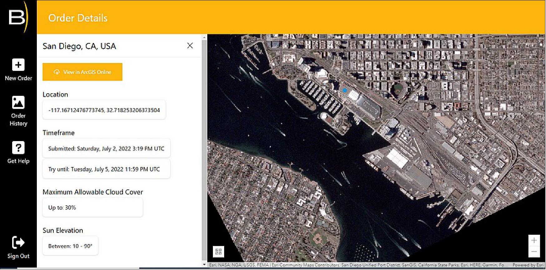
• July 12, 2022: BlackSky Technology unveiled satellite tasking on July 12 through Esri’s ArcGIS Online geographic mapping platform at the Esri (Environmental Systems Research Institute) User Conference in San Diego. 25)After working closely together, BlackSky and Esri released BlackSky Tasking, a cloud-based application that allows Esri and BlackSky customers to task a satellite and receive the imagery in ArcGIS Online.
- Earth observation companies are reinventing satellite tasking to appeal to new and established customers. BlackSky joined forces with Esri due in part to ArcGIS Online’s millions of users in 300,000 organisations. BlackSky operates a constellation of 14 Earth observation satellites. The company offers customers access to data from its own constellations and other sources through its cloud-based Spectra AI platform.
• April 4, 2022: BlackSky‘s newest satellites successfully began revenue-generating commercial operations for customers, taking high-resolution images and creating analytics within a company record of 12 hours after launch. 26)The company expanded its constellation from 12 to 14 high-resolution satellites following the successful RocketLab launch “Without Mission a Beat” on Saturday, April 2. This mission marks the fourth BlackSky satellite launch mission in the last four months.
- The company’s expanded constellation enhances its ability to monitor and analyze the most strategic activities, locations, and economic assets in the world for its customers around the globe. The expansion of its constellation improves BlackSky’s daily dawn-to-dusk site monitoring and increases the frequency at which the company can image and analyze a particular site with an average daily revisit rate of eight to ten times a day in most locations in the world.
• December 13, 2021: Satellite imagery and data analytics provider BlackSky over the past 30 days launched six satellites on three different missions. 28)Reaching 12 satellites was a key goal for the company following the loss of two spacecraft in May in a failed Rocket Lab mission. BlackSky had originally planned to start deploying its new Gen-3 satellites in 2022 but is now targeting the first launch in 2023. Gen-3 satellites will produce images with 50-cm resolution, compared to the current Gen-2 version that provides one-meter imagery. Some of the company’s current satellites can capture images of the same location 15 times a day, which helps track economic trends and monitor areas of interest to national security agencies.

- BlackSky, which entered the market seven years ago, is competing against established players like Planet and faces emerging competitors in the remote-sensing industry. Investors have shown an appetite for companies in the satellite imagery business. Both BlackSky and Planet are now publicly traded. The company submitted a bid for a National Reconnaissance Office (NRO) imagery contract that the agency plans to award in mid-2022 to multiple commercial providers. The NRO, which currently buys most of its commercial satellite imagery from Maxar, is expected to select new providers to diversify its supplier base. BlackSky also expects to increase sales of data analytics services to the National Geospatial-Intelligence Agency (NGA) which recently announced plans to rely more on commercial providers. The U.S. Space Force (USSF) and the Space Development Agency are potential customers as well, but there is less demand from military buyers.
• December 7, 2021: BlackSky plans to add another two satellites to its constellation Wednesday (Dec. 8 in USA) with the Rocket Lab mission titled “A Data with Destiny.” Two satellites from the successful SpaceX mission Thursday (Dec. 2) began delivering revenue-generating insights for customers less than 24 hours following launch and increased constellation revisit rates to six consistent visits per day in key markets during daylight hours. 29)
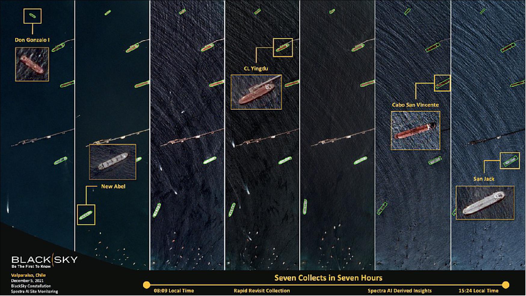
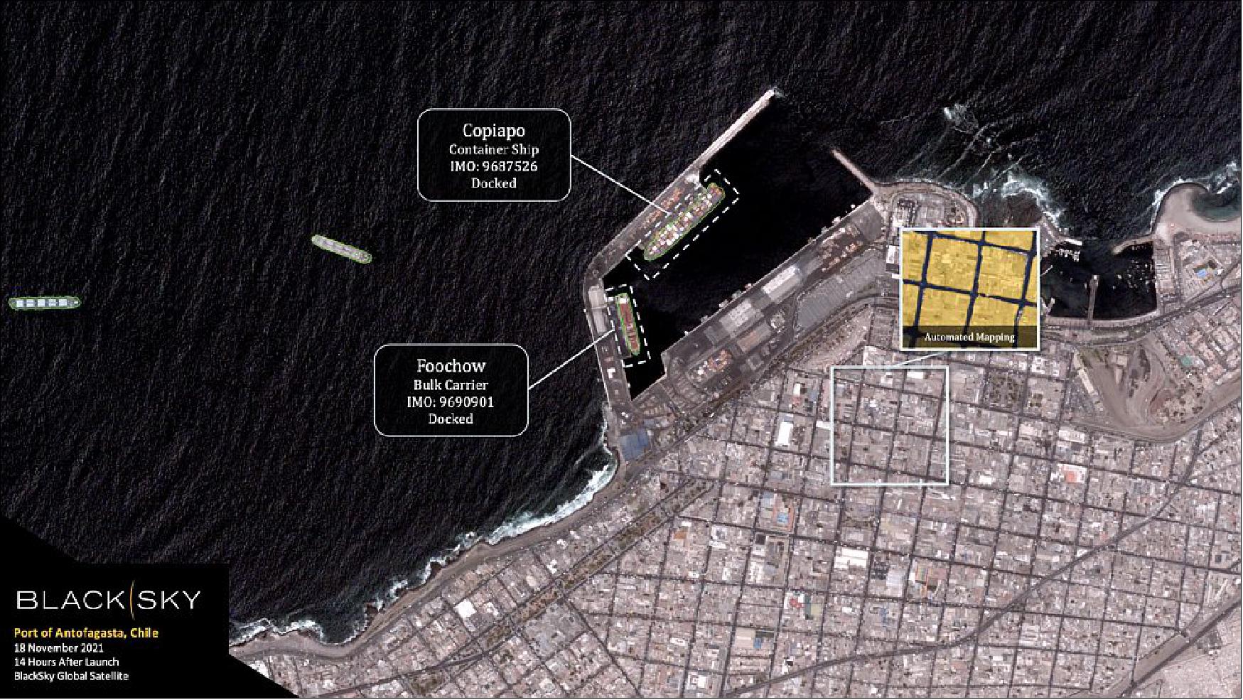
• November 18, 2021: BlackSky’s latest microsatellites (Global-8 and Global-9), launched with the Electron rocket of Rocket Lab, reached orbit and delivered first insights within 14 hours of launch. The company’s constellation growth signals a return to space and an increased capacity for global customers. 30) Through its growing constellation of high-revisit satellites, BlackSky’s real-time global intelligence services provides enhanced situational awareness for commercial and government customers around the world.
• August 17, 2021: BlackSky today announced that it has been awarded a contract modification from the National Reconnaissance Office (NRO) to provide on-demand satellite imagery through a monthly subscription. The requirements and funding for this effort will be transferred to NRO’s Electro-Optical Commercial Layer program. 31)
- BlackSky’s high-resolution satellite constellation will generate imagery for defense and intelligence communities to support homeland defense, national security, disaster and emergency response missions. BlackSky’s real-time imagery offers timely and relevant information on pattern-of-life anomalies that meet critical mission requirements and enable warfighters to make informed decisions.
- BlackSky’s satellites provide high, intraday revisit capabilities, allowing customers to receive multiple images a day, throughout the day, rather than just one image collected at roughly the same time each day. BlackSky seeks to build its constellation to 30 high-resolution multi-spectral satellites capable of monitoring the most important locations on Earth every 30 minutes, day or night. Early 2021, BlackSky announced a planned business combination with Osprey Technology Acquisition Corp. BlackSky currently anticipates closing the transaction during the third quarter of 2021.
• August 11, 2021: BlackSky was set add six satellites to its constellation through three dedicated missions via Rocket Lab and launch services provider, Spaceflight Inc. The first mission, called "Love at First Insight," was scheduled to occur in late-August and will be quickly followed by the next two missions. 32) BlackSky's existing constellation of satellites captures and delivers imagery and information to customers worldwide. The company's pace of launches and swift commissioning process is expanding its ability to deliver real-time insights that enable customers to make informed decisions with confidence.
- With more satellites on orbit, BlackSky would be able to provide deeper data and analytics on pattern-of-life anomalies and situational awareness for government and commercial entities who rely on its intelligence. BlackSky expects to achieve a 14-smallsat constellation by the end of 2021. The upcoming missions are part of a multi-launch agreement between BlackSky, Spaceflight Inc. and Rocket Lab announced earlier this year. BlackSky's satellite development and manufacturing partner, LeoStella, utilised its high throughput satellite factory to produce these six satellites at an accelerated pace and shipped them to Rocket Lab's launch site in New Zealand. Collectively, BlackSky, LeoStella, Spaceflight, and Rocket Lab are demonstrating how established expertise, shared understanding of systems, and innovative technologies work together to help accelerate speed to space.
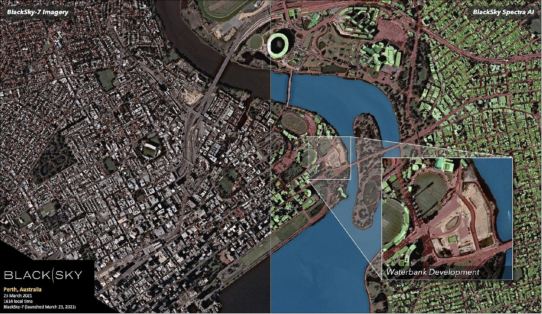
• March 25, 2021: BlackSky reported it has secured five Rocket Lab missions to deploy nine satellites between March and the end of 2021. The first of these launches took place on March 22, 2021. The company accelerated the deployment of its constellation of Gen-2, high-revisit, high-resolution imaging satellites and expects to deliver capabilities in 2021 that were originally planned for delivery in 2022. 33)These launch missions enable BlackSky to fast-track its plans to offer one-hour average dawn-to-dusk imaging revisits and 90-minute average delivery times for its customers. In 2023, BlackSky expects to begin including its recently announced Gen-3 satellites, which are intended to have 50 cm resolution and short-wave infrared (SWIR) for low light and nighttime imaging capabilities, moving toward the completion of its projected 30-spacecraft constellation.
- The multi-launch agreement, inked with launch services provider Spaceflight Inc. who will manage the integration and launch services for BlackSky, includes the launch of nine BlackSky satellites across five Electron missions this year. Collectively, BlackSky, Spaceflight and Rocket Lab are demonstrating how established expertise, shared understanding of systems, and innovative technologies work together to help accelerate speed to space. LeoStella, BlackSky’s smallsat development and manufacturing partner, produced the nine BlackSky Gen-2 satellites that are being delivered to Rocket Lab’s launch site in New Zealand.

- BlackSky’s Gen-2 satellite was designed and manufactured by LeoStella, BlackSky’s smallsat development and manufacturing partner. BlackSky 7 is another satellite off the LeoStella manufacturing line, where an additional 16 BlackSky satellites are in production. Through its growing constellation of high-revisit satellites, BlackSky monitors global events and activities providing enhanced situational awareness for commercial and government customers around the world.
- BlackSky offers geospatial solutions to customers, including optical data and analytics via the company’s Spectra AI platform. Established in Asia, Geo-Insights has the capability to provide geospatial solutions that integrate optical and synthetic aperture radar (SAR) data. Both parties expect to further evaluate options to expand their offerings with a new suite of jointly developed optical/SAR geospatial intelligence products powered by the latest advancements in artificial intelligence and machine learning algorithms.

• February 18, 2021: BlackSky, a provider of satellite imagery and geospatial intelligence, announced Feb. 18 it has signed a deal to go public through a merger with Osprey Technology Acquisition Corp. 36) Osprey is a special purpose acquisition company. SPACs raise money from investors, merge with a privately held company that then becomes publicly traded. The merger with Osprey will bring a $450 million cash infusion to BlackSky, he said. Once the company goes public, its estimated value will be about $1.5 billion. When the deal is completed, O’Toole said, Osprey will own a portion of the company but current BlackSky shareholders will continue to hold majority ownership. BlackSky is the latest player in the space industry to jump on the SPAC bandwagon. These deals provide private companies an easier path to go public and give them access to funding relatively quickly.
- Based in Seattle and in Herndon, Virginia, BlackSky was founded in 2014 as a global monitoring company. It operates a constellation of small imaging satellites that circle the Earth at high revisit rates. It also collects data from other organizations’ satellites and from open sources of information. The company uses artificial intelligence and machine learning software to turn the data into actionable insights. Its satellites are manufactured by LeoStella, joint venture with Thales Alenia Space. BlackSky has five satellites in orbit and plans to deploy 25 more over the next several years. The additional satellites will allow 30-minute revisit cycles. BlackSky also is developing a new satellite that will provide higher resolution imagery.

- BlackSky’s fifth and sixth satellites are already delivering enhanced image performance and growing revisits for BlackSky customers. By flying at lower altitudes than other satellites in BlackSky’s constellation, these latest two satellites can produce images with resolution up to 80 cm — a 20 percent improvement over the existing satellites in the constellation. The position of these satellites at an inclination of 53 degrees will allow additional revisits across all markets with heightened performance in Europe and Asia. These advances will unlock more analytic and data driven opportunities for BlackSky’s customers. The BlackSky constellation now includes six satellites. The company is on track to add 10 more satellites to its constellation by the end of 2021.
• September 24, 2020: BlackSky, a provider of geospatial intelligence, announced Sept. 24 it will add new satellites to its network that will provide high-resolution and nighttime imagery. 38) The new so-called Gen-3 satellites will produce images with 50-centimeter resolution, compared to the current Gen-2 satellites that provide one-meter imagery. The first Gen-3 satellites will launch in 2022.The U.S. Army could be one of the users of Gen-3 satellites. BlackSky in January received a contract to prototype the service from the Defense Innovation Unit, the Pentagon’s outreach organisation that works with commercial tech industries.
- Under the Army’s “tactical geoint” program, military users will be able to task a Gen-3 satellite. The Army can downlink imagery to its existing remote ground terminals. Under the contract, BlackSky will provide analytics services using artificial intelligence and machine learning algorithms. The Gen-3 satellites will have dual optical-infrared sensor payloads that can see at nighttime, in low light conditions and in bad weather. The Gen-3 design is a larger modified version of the 50 kg Gen-2 microsatellites produced by BlackSky’s sister company LeoStella, based in Seattle, Washington. BlackSky had six Gen-2 satellites on orbit in 2020.

• April 22, 2020: BlackSky announced today its new Spectra On-Demand Secure Bundle to support remote work options for intelligence analysts. The new Spectra solution allows analysts to securely share unclassified information. The Spectra On-Demand Secure Bundle includes the ability to review multi-source data feeds, obtain timely access to satellite imagery and gain resources for event analysis. 40)
- The Spectra On-Demand Secure Bundle offers global monitoring and satellite imaging including: Global activity monitoring: Access, coordination and management of a wide range of open and commercial monitoring source, Comprehensive commercial satellite imagery: Fast tasking and delivery with rapid access to image archives, Automated tipping and cueing: Rapid selection and tasking of the right sensor at the right time, Secure online environment for analyst collaboration, publication and dissemination: Internet accessible and unclassified resources. Strategic focus for the new Spectra On-Demand Secure Bundle includes site, activity and crisis monitoring while leveraging ad-hoc imagery ordering.
• November 12, 2019: An industry first will create a strategic relationship that pairs Earth observation with a global communications infrastructure. The companies are BlackSky, provider of geospatial intelligence, satellite imaging and global monitoring services, and a $50 million senior secured loan from the global satellite communications company, Intelsat . BlackSky currently has four 1-meter satellites in orbit with another four slated for launch in early 2020, and plans to have 16 satellites in its constellation by early 2021. 41) 42)
- The new capital enables BlackSky to further its existing assets and alliances to remain competitive in delivering Earth intelligence faster, with greater accuracy and more affordably. The objective is that over time, BlackSky could incorporate access to Intelsat’s global communications infrastructure, delivering first-to-know insights to customers anywhere in the world. With an established manufacturing capability, mission operations center and sales channels in place, BlackSky is in the process of expanding its constellation of smallsats. The company is also leading the industry in fusing AI/ML (Artificial Intelligence/Machine Learning)-powered computer vision, high revisit rate imagery from orbital assets and open-source intelligence to provide customers with comprehensive, deep insights about the locations in the world they care about.
• June 6, 2019: The NRO (National Reconnaissance Office’s) friendly outreach to commercial suppliers of satellite imagery that for years have felt shut out of the market. 43) The NRO announced June 3 that the agency in 2020 will start a new procurement that will include multiple companies. To begin the process, it awarded one-year contracts to Maxar and two other suppliers - Planet and BlackSky - to allow the NRO to study the companies’ products and gain insight into the projected size and capacity of their satellite constellations. The NRO calls these “study contracts” because the information they receive from vendors will be used by the agency to examine the companies’ abilities to task, collect process and deliver satellite imagery. A newly created Commercial Systems Program Office at the NRO will oversee the procurement of imagery.
- Both Planet and BlackSky are commercial players that have been eager for a shot at the biggest imagery buy from the U.S. government. When BlackSky was formed in 2015, several of its employees were GeoEye and DigitalGlobe alumni. At the same time, BlackSky is rapidly building a commercial business. Based in Seattle, BlackSky is owned by Spaceflight Industries, a space services firm. BlackSky has two Earth imaging satellites in operation and plans to have eight in service by year’s end, Herman said. The company’ long-term goals are to deploy 30 satellites by 2023, and possibly 60 in the years after, depending on the market demand. BlackSky supplies high-revisit imagery but primarily sees itself as a provider of global monitoring and alerting services that combine pictures — taken by its own satellites and other companies’ satellites — with other sources of intelligence such as social media, news and other data feeds.
• March 6, 2018: BlackSky, the geospatial intelligence service of Spaceflight Industries, today announced the first of its next generation of small Earth observation satellites is complete, qualified, and awaiting launch. This spacecraft, called Global-1, is the first of four smallsats that are scheduled to launch in the next year on both US and foreign launch vehicles. 44) The Global series of spacecraft builds on the success of BlackSky’s initial technology demonstration spacecraft, called Pathfinder, which was launched in September 2016. The Global spacecraft provides 1-meter resolution and features improved image quality, geolocation accuracy, and on-orbit lifetime. The spacecraft is complemented by an enhanced ground system to minimize the latency between image tasking and receipt.
- BlackSky’s Global smallsats will join the virtual constellation of commercial imaging satellites accessible through the BlackSky geospatial platform. Within the platform, users can access BlackSky Spectra’s on-demand imagery service to search, purchase, task, and download visual imagery and multi-spectral data from a global collection network. They can also subscribe to BlackSky Events, the platform’s global event monitoring service that fuses news, social media, industry data services, and physical sensor networks to provide early warning and insights on risks, threats, and opportunities that can impact their business. The platform is currently in use by several large government and commercial organizations to actively monitor global assets.
• September 15, 2017: The Space Alliance, formed by Thales Alenia Space (Thales 67%, Leonardo 33%) and Telespazio (Leonardo 67%, Thales 33%), today signed a partnership with the US-based company Spaceflight Industries of Seattle, WA, which includes the following elements: 45) A minority investment in Spaceflight Industries, which through its BlackSky business, has developed a geospatial platform and plans to build and operate a constellation of 60 small high-resolution observation satellites featuring very short revisit times. The creation of an industrial Joint Venture in the United States between Thales Alenia Space and Spaceflight Industries specialized in the production of small satellites. The implementation of a Joint Cooperation and Marketing Agreement between Telespazio and BlackSky enhancing their respective product and analytics portfolios on the market.
• December 14, 2016: Spaceflight Industries today announced the availability of its BlackSky global intelligence platform, as well as its EAP (Early Adopter Program) participants, and the diverse partner ecosystem fueling the platform. The highly scalable, cloud-based platform enables organizations to observe, analyze and act on global events as they happen. The BlackSky platform integrates diverse sensors and data – including satellite imagery, social media and other data feeds – to reveal timely and relevant insights around specific topics or locations. 46)
Currently, the platform is in early adoption with a select group of customers, including the World Bank, RS Metrics, United Nations, and others. The BlackSky platform offers two major capabilities:
1) Imagery: Customers can discover, purchase and download imagery via the BlackSky platform, which currently provides access to more than 10 high-resolution imaging spacecraft including those from 21AT’s TripleSat constellation, SIIS’s (SI Imaging Services) KOMPSAT, and UrtheCast’s Deimos-2. Additionally, customers can acquire real-time images by tasking partner satellite systems and soon the BlackSky constellation.
2) Insights: The platform fuses the satellite imagery with information from other sources including news outlets and social media to create curated data feeds by location (ex: port, pipeline, border) or theme (ex: geopolitical conflict, natural disasters, energy, or health/outbreak).
Key features of the BlackSky global intelligence platform include:
- Ease of use: BlackSky’s easy-to-use web-based interface speeds and simplifies the viewing, purchasing and downloading of geospatial products. Users can securely log on, search the archive of images, task or request a new image (complete with “add to shopping cart” functionality), analyze and store data via the secure Web portal.
- Rapid revisit: Through its vast partner satellite systems, the platform provides access to the largest virtual commercial constellation with industry-leading revisit abilities. The deployment of the 60-satellite BlackSky satellite constellation will provide a rapid revisit rate with the ability to pass over key zones hourly, making images fresher to provide a more comprehensive story.
- Affordability: BlackSky holds a unique market position as a product offering of Spaceflight Industries, which develops launch capabilities, innovative spacecraft, communications networks and cloud-based software services.
• November 14, 2016: Following the launch, the Spaceflight Industries’ operations team has conducted extensive spacecraft level testing and is currently in the process of working through payload calibration as well as transitioning to automated operations. Pathfinder-1 is presently operating in a 690 km circular orbit because it was launched as a rideshare spacecraft, while the future BlackSky constellation will operate at 450 km - providing 1 m resolution. 47) 48)
- The following first sample images of the BlackSky Pathfinder-1 spacecraft were presented by the BlackSky project on Nov. 14, 2016. Even at the present altitude of 690 km the project at Spaceflight Industries is pleased with the detail and performance. Each image spans an area measuring about 10 km x 3 km, with a resolution of ~2 m/pixel. 49)


• Sept. 27, 2016: BlackSky Global announced the successful launch of Pathfinder-1 and the subsequent first communication 50)
Sensor Complement
SpaceView 24™
The spacecraft is equipped with a SV-24 (SpaceView 24™) imaging telescope, built by Harris Corporation, allowing it to image an area approximately 30 km2 at high resolution.
Harris SpaceView™ payloads provide high-resolution imagery in a small, lightweight form factor. With apertures ranging from 0.24 m to 0.7 m, SpaceView™ systems meet imaging and size, weight and power requirements for nanosats, microsats, and smallsats with high-resolution imaging ranging from 0.24 m – 1.1 m GSD (Ground Sample Distance). SpaceView™models 24, 36, and 42 are high-resolution payloads that even offer the potential to capitalize on standard ESPA(EELV Secondary Payload Adapter) APL envelope configurations. 51)
SpaceView 24™ imaging telescope parameters:
- Aperture: 24 cm diameter
- Payload mass: < 10 kg
- Resolution @500km (GSD): 0.9-1.1 m.
- Sensor capabilities: • Staring, • Motion, Imagery/ Video, • Low Light.
- Bands: Visible Pan / Color.

References
1) Caleb Henry, “BlackSky Global Details Plans for 60 Satellite Earth Observation Constellation,” June 16, 2015, URL: http://www.satellitetoday.com/technology/2015/06/16/blacksky-global-details-plans-for-60-satellite-earth-observation-constellation/
3) ”A Revolutionary Change in Earth Observation,” BlackSky Global, URL: http://geosmartasia.org/2015/pdf/jHornsby.pdf
4) “AllSource and BlackSky Global Create Content Partnership,” AllSource Analysis, June 23, 2015, URL: http://allsourceanalysis.com/wp-content/uploads/2015/07/BlackSkyAllSource.pdf
5) ”BlackSky inks US deal to enhance global decision-making,” Space Daily, May 2, 2016, URL: http://www.spacedaily.com/reports/BlackSky_Inks_Partnership_with_United_Nations_to_Enhance_Global_Decision_Making_999.html
6) ”BlackSky Awarded Five-Year Joint Artificial Intelligence Center Contract for AI Data Readiness,” BlackSky Press Release, 21 June 2022, URL: https://ir.blacksky.com/news-events/press-releases/detail/71/blacksky-awarded-five-year-joint-artificial-intelligence
7) Sandra Erwin, ”BlackSky looks to expand its military business amid growing interest in commercial satellite imagery,” SpaceNews, 7 April 2022, URL: https://spacenews.com/blacksky-looks-to-expand-its-military-business-amid-growing-interest-in-commercial-satellite-imagery/
8) Sandra Erwin, ”U.S. government contracts lift BlackSky’s financial performance,” SpaceNews, 12 November 2021, URL: https://spacenews.com/u-s-government-contracts-lift-blackskys-financial-performance/
9) ”BlackSky Announces Completion of Merger with Osprey Technology Acquisition Corp.,” BlackSky, 9 September 2021, URL: https://www.blacksky.com/2021/09/09/blacksky-announces-completion-of-merger-with-osprey-technology-acquisition-corp/
10) ”Deep Space Industries to provide Comet satellite propulsion for Astro Digital,” DSI, April 2018, URL: https://web.archive.org/web/20180719230104/http://deepspaceindustries.com:80/deep-space-industries-to-provide-comet-satellite-propulsion-for-astro-digital/
11) ”Deep Space Industries' 'Wet and Wild' Solutions Will Use Comet's Water-Based Satellite Propulsion for BlackSky's Satellites,” Satnews Daily, 3 April 2018, URL: http://www.satnews.com/story.php?number=914232479
12) ”PSLV-C35 / SCATSAT-1, ISRO, Sept. 26, 2016, URL: http://www.isro.gov.in/launcher/pslv-c35-scatsat-1
13) ”PSLV-C35 / SCATSAT-1 Brochure,” ISRO, URL: http://www.isro.gov.in/pslv-c35-scatsat-1/pslv-c35-scatsat-1-brochure-0
14) ”Spaceflight Industries Celebrates Successful Launch of the BlackSky Pathfinder Satellite Aboard India’s PSLV,” BlackSky, 26 Sept. 2016, URL: https://web.archive.org/web/20180309211612/https://www.blacksky.com/2016/09/26/spaceflight-industries-celebrates-successful-launch-of-the-blacksky-pathfinder-satellite-aboard-indias-pslv/
15) ”PISAT nanosatellite ready for space launch in July 2016,” PES News, April 20, 2016, URL: http://news.pes.edu/pisat-nanosatellite-ready-for-space-launch-in-july-2016/
16) Stephen Clark, ”Spaceflight’s 64-satellite rideshare mission set to last five hours,” Spaceflight Now, 3 December 2018, URL: https://spaceflightnow.com/2018/12/03/spaceflights-64-satellite-rideshare-mission-set-to-last-five-hours/
17) ”Spaceflight Successfully Launches 64 Satellites on First Dedicated Rideshare Mission,” BlackSky Press Release, 3 December 2018, URL: https://www.spaceflightindustries.com/category/blacksky-press-releases/
18) ”Spaceflight SSO-A: SmallSat Express Mission,” SpaceX, 3 December 2018, URL: https://web.archive.org/web/20181204085402/https://www.spacex.com/news/2018/12/03/spaceflight-sso-smallsat-express-mission
19) ”Spaceflight - Introducing SSO-A: The smallsat express,” Spaceflight, 3 December 2018, URL: http://spaceflight.com/sso-a/
20) ”Rocket Lab successfully launches seventh Electron mission, deploys seven satellites to orbit,” Rocket Lab, 29 June, 2019, URL: https://www.rocketlabusa.com/news/updates/rocket-lab-successfully-launches-seventh-electron-mission-deploys-seven-satellites-to-orbit/
21) ”Rocket Lab successfully launches ninth Electron mission, deploys payload to highest orbit yet,” Rocket Lab, 17 October, 2019, URL: https://www.rocketlabusa.com/news/updates/rocket-lab-successfully-launches-ninth-electron-mission-deploys-payload-to-highest-orbit-yet/
22) ”BlackSky Earth-observing satellites lost due to anomaly during Rocket Lab launch,” GeekWire, 15 May 2021, URL: https://www.geekwire.com/2021/blacksky-earth-observing-satellites-lost-due-anomaly-rocket-lab-launch/
23) ”A Data With Destiny,” Rocket Lab, 9 December 2021, URL: https://www.rocketlabusa.com/missions/completed-missions/a-data-with-destiny/
24) ”Without Mission A Beat,” Rocket Lab, 2 April 2022, URL: https://www.rocketlabusa.com/missions/completed-missions/without-mission-a-beat/
25) Debra Werner, ”BlackSky and Esri unveil tasking through ArcGIS Online,” SpaceNews, 12 July 2022, URL: https://spacenews.com/blacksky-esri-tasking/
26) ”BlackSky Expands Constellation to 14 Satellites and Increases Capacity Over Critical Locations,” BlackSky, 4 April 2022, URL: https://www.blacksky.com/2022/04/04/blacksky-expands-constellation/
28) Sandra Erwin, ”BlackSky to begin transition to higher-resolution imaging satellites in 2023,” SpaceNews, 13 December 2021, URL: https://spacenews.com/%e2%80%a8blacksky-to-begin-transition-to-higher-resolution-imaging-satellites-in-2023/
29) ”BlackSky Continues Operational Momentum with Two Back-to-Back Launches in Six Days,” BlackSky, 7 December 2021, URL: https://www.blacksky.com/2021/12/07/blacksky-continues-operational-momentum-with-two-back-to-back-launches-in-six-days/
30) ”BlackSky On Track to Significantly Expand its Constellation this Year Meeting an Expanding Demand for Real-time Global Intelligence,” BlackSky Press Release, 18 November 2021, URL: https://www.blacksky.com/2021/11/18/blacksky-on-track-to-significantly-expand-its-constellation-this-year-meeting-an-expanding-demand-for-real-time-global-intelligence/
31) ”NRO Expands BlackSky Commercial Imagery for Security, Defense and Intelligence,” BlaykSky , 17 August 2021, URL: https://www.blacksky.com/2021/08/17/nro-expands-blacksky-commercial-imagery-for-security-defense-and-intelligence/
32) ”BlackSky to expand constellation with three back-to-back missions,” Space Daily, 11 August 2021, URL: https://www.spacedaily.com/reports/BlackSky_to_expand_constellation_with_three_back_to_back_missions_999.html
33) ”BlackSky Accelerates Constellation Deployment with Five Rocket Lab Launches,” BlackSky, 25 March 2021, URL: https://www.blacksky.com/2021/03/25/blacksky-accelerates-constellation-deployment-with-five-rocket-lab-launches/
34) ”BlackSky’s Newest Satellite Delivers First Insights Within 24 Hours,” BlackSky, 25 March 2021, URL: https://www.blacksky.com/2021/03/25/blackskys-newest-satellite-delivers-first-insights-within-24-hours/
35) ”ST Engineering Geo-Insights partners with BlackSky to offer expanded satellite imaging and analytics insights portfolio for customers in Southeast Asia,” BlackSky, 1 March 2021, URL: https://www.blacksky.com/2021/03/01/st-engineering-geo-insights-partners-with-blacksky-to-offer-expanded-satellite-imaging-and-analytics-insights-portfolio-for-customers-in-southeast-asia/
36) Sandra Erwin, ”Satellite imagery and data firm BlackSky to go public in latest SPAC deal,” SpaceNews, 18 February 2021, URL: https://spacenews.com/satellite-imagery-and-data-firm-blacksky-to-go-public-in-latest-spac-deal/
37) ”BlackSky’s Newest Satellites Have Completed Commissioning and Entered Into Commercial Operations,” BlackSky, 5 October 2020, URL: https://www.blacksky.com/2020/10/05/blackskys-newest-satellites-completed-commissioning-commercial-operations/#
38) Sandra Erwin, ”BlackSky to add high-resolution satellites in 2022, signs deal with U.S. Army,” SpaceNews, 24 September 2020, URL: https://spacenews.com/blacksky-to-add-high-resolution-satellites-in-2022-signs-deal-with-u-s-army/
39) ”New BlackSky Satellites Deliver First Images Within 58 Hours of Launch,” BlackSky, 17 August 2020, URL: https://blacksky.com/2020/08/17/new-blacksky-satellites-deliver-first-images-within-58-hours-of-launch/
40) ”BlackSky Launches Spectra On-Demand Secure Bundle for Intelligence Analysts,” BlackSky Press Release, 22 April 2020, URL: https://blacksky.com/2020/04/22/blacksky-launches-spectra-on-demand-secure-bundle-for-intelligence-analysts/
41) ”Industry First ... $50M in Funding for EO to BlackSky from Intelsat,” Satnews Daily, 12 November 2019, URL: http://www.satnews.com/story.php?number=1726919997
42) ”BlackSky secures $50M in funding from Intelsat,” BlackSky News, 12 November 2019, URL: https://web.archive.org/web/20200105144356/https://www.blacksky.com/2019/11/12/blacksky-secures-50m-funding-intelsat/
43) Sandra Erwin, ”Satellite imagery startups to challenge Maxar for big government contracts,” Space News, 6 June 2019, URL: https://spacenews.com/satellite-imagery-startups-to-challenge-maxar-for-big-government-contracts/
44) ”BlackSky Completes Its First Next-Generation Earth Imaging Smallsat, Readies for Launch and Commercial Availability,” BlackSky News, 6 March 2018, URL: https://web.archive.org/web/20200511104400/https://blacksky.com/2018/03/06/blacksky-completes-its-first-next-generation-earth-imaging-smallsat-readies-for-launch-and-commercial-availability/
45) ”Thales Alenia Space, Telespazio and Spaceflight Industries Partner to Accelerate the BlackSky Geospatial Platform and High Revisit Rate Constellation,” Spaceflight Industries Press Release, Sept. 15, 2017, URL: http://tinyurl.com/yasxwmvk
46) ”Spaceflight Industries Unveils its BlackSky Platform for Observing the Planet,” BlackSky, Dec. 14, 2016, URL: https://www.blacksky.com/2016/12/14/spaceflight-industries-unveils-its-blacksky-platform-for-observing-the-planet
47) ”Spaceflight Industries Shares First Images from BlackSky Pathfinder Satellite, Claims Mission Success,” BlackSky Press Release, Nov. 14, 2016, URL: https://www.blacksky.com/2016/11/14/spaceflight-industries-shares-first-images-blacksky-pathfinder-satellite-claims-mission-success/
48) ”Spaceflight's BlackSky Pathfinder-1 Satellite Has Its First 'Show And Tell' Photos,” Satnews Daily, Nov. 15, 2016, URL: http://www.satnews.com/story.php?number=1358925533
49) Jason Andrews, ”Hello beautiful! Our first pictures from Pathfinder-1 represent complete mission success,” Spaceflight Industries, Nov. 14, 2016, URL: https://web.archive.org/web/20161115092038/https://www.blacksky.com/2016/11/14/hello-beautiful-first-pictures-pathfinder-1-represent-complete-mission-success/
50) Hilary Meyerson, ”Confirmed Communication from Pathfinder-1,” BlackSky News, Sept. 27, 2016, URL: http://www.blacksky.com/2016/09/27/confirmed-communication-pathfinder-1/
51) ”SpaceViewTM Small Satellite Imaging Solutions,” Harris brochure, URL: https://www.harris.com/sites/default/files/downloads/solutions/55523_spaceview_brochure_4_v8_mv_final_web.pdf
52) “BlackSky 1, ..., 60.” Gunter's Space Page, URL: https://space.skyrocket.de/doc_sdat/blacksky-global.htm
Spacecraft Launch Mission Status Sensor Complement References Back to top