GLORIA (Gimballed Limb Observer for Radiance Imaging of the Atmosphere)
Airborne Sensors
GLORIA (Gimballed Limb Observer for Radiance Imaging of the Atmosphere)
Overview Instrument Concept and measurement modes Campaigns References
GLORIA is a German airborne imaging FTS (Fourier Transform Spectrometer) which is capable of operating on various airborne platforms. The main scientific focus is on the dynamics and chemistry of the UTLS (Upper Troposphere and Lower Stratosphere) region. The instrument is capable of measuring in limb and nadir geometry and has flexibility in terms of spatial and spectral sampling. The limb sounding mode is used to explore transport processes between different compartments of the atmosphere that takes place on scales satellite instruments are not able to resolve. 1) 2) 3)
Mode | Dynamics | Chemistry |
Lower limit of FOV | -3.27º (4 km) | -3.27º (4 km) |
Horizontal FOV | 4.07º | 4.07º |
Vertical sampling | 140 m | 560 m |
Horizontal sampling | 2.2 km | 17.9 km |
Planning | 45º - 135º | 90º |
Spectral coverage | 780-1400 cm-1 (or 7-13 µm) | 780-1400 cm-1 |
Spectral resolution | 1.25 cm-1 | 0.1 cm-1 |
NESR (Noise-Equivalent Spectral Radiance) | 3.5 nW/(cm2 sr cm-1) | 2 nW/(cm2 sr cm-1) |
Acquisition time | ~3 s | ~36 s |
The instrument is a joint development of the research centers KIT (Karlsruher Institut für Technologie) and the Forschungszentrum (Research Center) Jülich. The University of Wuppertal is also a partner in the project. 5) 6) 7)
Sensor Complement
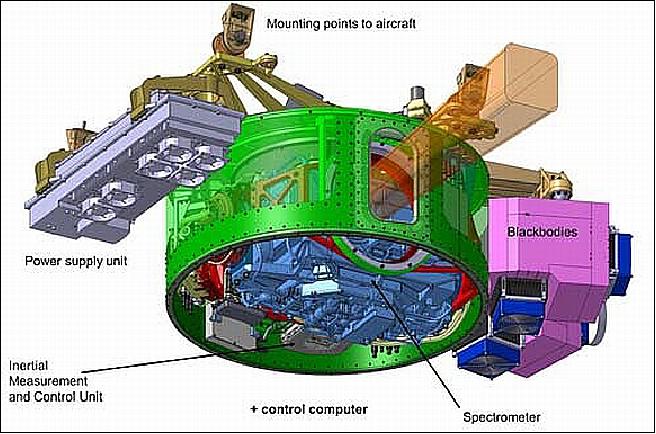
The heart of the instrument is a Michelson interferometer with a maximum optical path difference of ± 8 cm. The interferometer is a single linear slide design with hollow cube corners. The interferometer is cooled to 215 K with the help of solid carbon dioxide. The infrared signal coming through the interferometer is imaged with an infrared lens system on the MCT (Mercury Cadmium Telluride) focal plane array (FPA). The detector is cooled to 60 K or less with a Stirling cooler. The detector has 256 x 256 elements. Depending on the scientific needs only a subset of the full array is used for performing the measurements Ref. 1).
The FOV (Field of View) is freely configurable from 8 x 8 to 128 x 128 pixels; typically 48 (horizontal) x 128 (vertical) pixels are used, corresponding to a FOV of 1.5° x 4°. The spectral coverage of the instrument in its current configuration is from 780 cm-1 to 1400 cm-1 (corresponding to 7-13 µm). The spectrometer is mounted inside a gimballed frame which ensures agility to move the instrument in three axes (elevation, azimuth and image rotation).
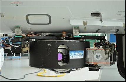
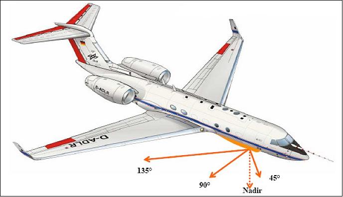
The spectrometer is mounted inside a gimballed frame which ensures agility to move the instrument in three axes (elevation, azimuth and image rotation). The scene can be stabilized on the FPA by compensating the aircraft roll, pitch and yaw movements. In limb mode, the horizontal viewing direction can be chosen freely within an angle range from 45° to 132° to the flight direction, to allow tomographic sampling of the atmosphere (so-called dynamics mode). The necessary altitude information for the system is generated by a dedicated high precision INS (Inertial Navigation System).
Calibration: Two large blackbodies with very high emissivity and thermoelectric temperature control are used for radiometric calibration. The blackbodies are operated in the range from 15 K below and at least 30 K above ambient temperature (Ref. 1).
The in-flight calibration system consists of two identical high-precision blackbodies (GBB-C and GBB-H), which are independently controlled at two different temperatures in the range of the atmospheric infrared radiance emissions. In order to operate GBB-C at 10 K below ambient temperature and GBB-H at 30 K above ambient temperature, respectively, TECs (Thermoelectric Coolers) are used offering the advantage of avoiding cryogens and mechanical coolers. An additional benefit of the TECs is the dual utilization for cooling and heating, by just switching the direction of the electrical current. For temperature control, PRTs (Platinum Resistance Thermometers) of type DIN B/10 are used with a nominal temperature uncertainty of 0.03 K at 0 °C. 8)
The GLORIA in-flight calibration system has been comprehensively characterized for its spatially (full aperture) and spectrally (7 µm to 13 µm) resolved radiation properties in terms of radiation temperature traceable to the international temperature scale (ITS-90) at the national metrology institute of Germany, PTB (Physikalisch-Technische Bundesanstalt), Braunschweig, Germany.
The instrument can be operated autonomously on the aircraft. A satellite link (Iridium) to a supervising ground station has been implemented for reacting to unforeseen problems and adapting the measurement plan. Alternatively, an instrument operator onboard may take care of the instrument operations.
GLORIA Instrument Concept and Measurement Modes
The GLORIA instrument takes limb images of the atmosphere from the flight altitude of HALO or M55-Geophysica down to 4 km, using a vertical sampling step of about 150 m at 10 km tangent height. Individual images contain 128 pixels (spectra) in the vertical dimension and 48 pixels in the horizontal dimension. The spectral range of the observations currently extends from about 780 to 1400 cm-1. The list of measurable quantities includes temperature, H2O, HDO, O3, CH4, N2O, CFC-11, CFC-12, HCFC-12, SF6, HNO3, N2O5, ClONO2, HO2NO2, PAN, C2H6, H2CO, NH3, and cirrus cloud quantities like effective radii and IWC (Ice Water Content). 9)
GLORIA is operated in a high-spectral, medium-spatial sampling ("chemistry") mode and a medium-spectral, high-spatial sampling ("dynamics") mode. The spectral samplings are 0.065 cm-1 for the chemistry mode and 0.65 cm-1 for the dynamics mode. Other combinations of spectral and spatial resolution can be used, if desirable for a specific scientific objective. In the dynamics mode, the time saved by running the interferometer at a much shorter optical path difference (i.e. lower spectral resolution) is used for panning the line of sight from about 45º to 135º with respect to the aircraft flight direction.
An illustration of the panning, which allows for tomographic applications, is given in the left panel of Figure 3. An illustration of the panning, which allows for tomographic applications, is given in the left panel of Figure 3. The overlap of different viewing angles in the same air volume can be used for tomographic retrievals, also in the case of a linear flight pattern (left panel of Figure 3). These tomographic capabilities can even be enhanced by choosing a closed flight pattern as illustrated in the right panel of Figure 3 for a circle. The high spatial density of tangent points resulting from the large range of viewing angles in a closed-path tomography is illustrated in Figure 4.
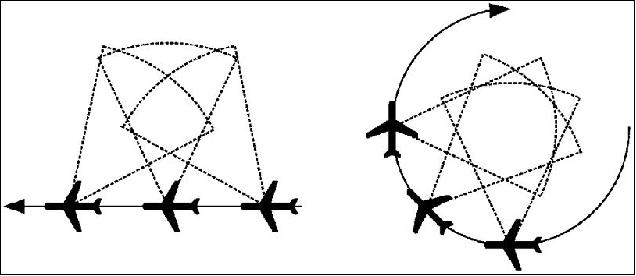
Legend to Figure 3: The panning range of the instrument is illustrated by dashed lines. LOS (Line-of-Sight) panning allows for tomographic measurements even during linear flights (left), since a fraction of the air volume covered is observed from different directions. The tomographic capabilities can be further enhanced by choosing a closed flight pattern like a circle (right).
The GLORIA chemistry mode is optimized in terms of spectral instead of horizontal resolution. The high-spectral sampling of about 0.065 cm-1 allows for the retrieval of trace gases which cannot (or less reliably) be derived in the dynamics mode. The larger interferometer sweep time needed for one limb image at maximum spectral resolution results in a reduced along-track sampling while maintaining the same vertical sampling at a fixed azimuth angle. The chemistry mode is especially suited for the reconstruction of 2D distributions (curtains) of a huge number of trace gases along the flight track rather than tomographically resolved 3D temperature or trace gas fields.
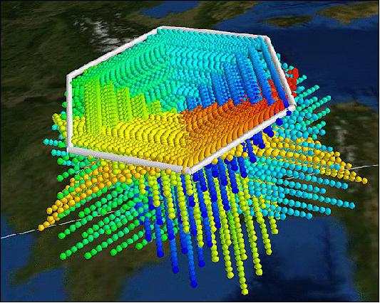
Legend to Figure 4: Each color corresponds to limb observations obtained for one flight segment. For example, red points correspond to measurements made during the first flight segment and blue points correspond to measurements made during the last flight segment. The tangent point density is highest in a 2–3 km thick layer below the flight level.
As an example, Figure 5 shows measurements of ethane (C2H6) retrieved from chemistry mode measurements on 18 September 2012 for a flight between the Maldives and Cyprus during the ESMVal (Earth System Model Validation) campaign. C2H6 is a typical tracer for polluted air, being produced by biomass burning and fossil fuel production with a tropospheric lifetime of a few months. The enhancements of C2H6 in Figure 5 point to transport of polluted air into the free troposphere and the UTLS either from local source or large-scale advection from the monsoon area.
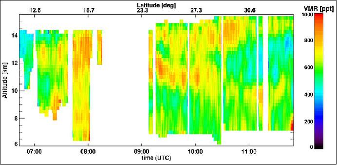
Figure 6 shows the HALO flight pattern south of Cape Town (South Africa) for 12 September 2012 during the ESMVal campaign. GLORIA encountered a situation with highly variable trace gas fields resulting from a planetary wavebreaking event, which is indicated by a large northward displacement of polar air at 12 km altitude. Polar vortex air can be identified by large absolute values of potential vorticity. The HALO flight track including the position of the tomographic hexagon and indications of tangent point locations is also shown in Figure 6.
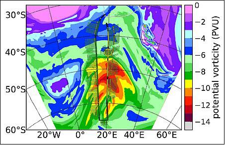
Legend to Figure 6: Colored areas indicate potential vorticity (PV) values at 12 km altitude. The flight path is shown by the colored line. Operation phases in the dynamics mode and chemistry mode are shown in yellow and green, respectively. The tomographic measurement, indicated by the hexagon, was made in an area of strong wave activity as reflected in the PV field.
First tomographic observations: The first tomographic observations took place during the TACTS and ESMVal aircraft campaign in summer/autumn 2012. Due to operational aircraft constraints, hexagons with a typical segment length of 200 km were chosen as closed paths instead of circles for enhanced tomographic applications. The high tangent point density results in a horizontal resolution of about 30 km x 30 km for temperature structures and atmospheric trace species such as ozone, HNO3, CFC-11, and water vapor.
First observations during the HALO missions TACTS and ESMVal in summer/autumn 2012 demonstrate the capability of GLORIA to resolve small-scale transport structures related to wave-breaking events. Figure 7 shows a baroclinic filamentary structure originating from shallow tropopause folds in the core of the jet stream and brought into the UTLS by a breaking Rossby wave. Dedicated studies of this quasi-horizontal transport are planned for the WISE (Wave-driven ISentropic Exchange) campaign (HALO) in the autumn of 2017. Imaging the structure and composition of filaments, ideally measuring it at multiple times during its evolution, in combination with trajectory analysis of its genesis and further evolution will provide case studies to benchmark model simulations against.
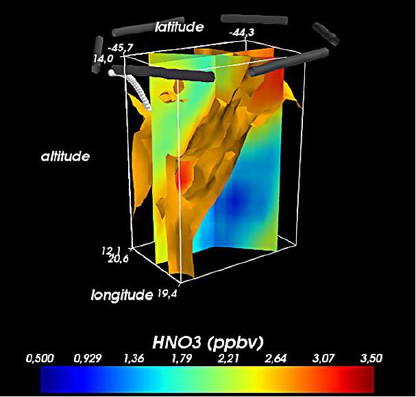
Legend to Figure 7: The HALO flight track at about 14 km is indicated by dark grey bars, which form a hexagon. The geographical location of this hexagon is shown in Fig. 7. The tomographic measurement volume below the flight track extends down to about 12 km. Individual tangent points are presented by small white spheres. The most prominent feature is a filament of stratospheric air (enhanced HNO3 values) that is surrounded by tropospheric air. The filament is illustrated by the 2.7 ppbv contour of enhanced HNO3 values. In addition, some cross sections of HNO3 values through the tomographic volume are displayed.
Measurement Campaigns
• In summer/autumn 2012, GLORIA was deployed on HALO during the TACTS (Transport and Composition in the Upper Troposphere/Lowermost Stratosphere) campaign: The first of six TACTS flights started in the last week of August, 2012: TACTS is a measurement campaign over several weeks coordinated by the University of Frankfurt. Measurements between Europe and Africa (Cape Verde) are planned. 10)
The GLORIA experiment is a central constituent of the HALO-TACTS scientific measurement campaign that is aimed at studying the composition of the upper troposphere and lowermost stratosphere along with exchange processes between such atmospheric compartments.
• The second campaign was done in April 2012 for test, certification and performance flights with the new HALO (High Altitude and LOng range), research aircraft of DLR (German Aerospace Center).
• The first measurement campaign, called ESSenCe (ESA Sounder Campaign), was conducted in December 2011 in Kiruna, Sweden. Two flights were performed during the campaign with the Russian research aircraft Geophysica M55.
Some Background on the HALO Aircraft
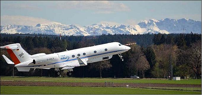
HALO is a modified aircraft, based on the Gulfstream G 550 ultra long range business jet. The aircraft performance permits payloads of up to 3000 kg and a range of well over 8000 km at cruising altitudes of 15 km (15.5 km max). HALO is the first aircraft capable of taking measurements on a continental scale. Any region from the poles to the tropics and remote areas of the Pacific can be reached in this research aircraft. As a result, it will be possible to answer scientific questions relating to areas that were inaccessible to previous research aircraft, especially the Falcon, operated by DLR (German Aerospace Center), Oberpfaffenhofen. 11) 12)
The HALO research aircraft was delivered on 21 January 2009 and landed at Oberpfaffenhofen after a non-stop transatlantic flight from Savannah, GA, USA. In 2012, it is available to both DLR – as the keeper of the aircraft – other research centers in the Helmholtz Association (Helmholtz-Gemeinschaft; HGF), universities, institutes of the Max Planck Society (Max-Planck-Gesellschaft; MPG) and other scientific establishments for investigations in the field of atmospheric research.
The HALO project was made possible by the Max Planck Society, members of the Helmholtz Association of German Research Centers (Helmholtz-Gemeinschaft Deutscher Forschungszentren) and a number of other scientific institutes from the field of atmospheric research. In total, 32 research institutes are participating in the project. The BMBF (Ministry of Education and Research) covered 70% of the total costs for HALO. The remaining costs are shared between the Helmholtz Association of German Research Centers and the Max Planck Society.
The following modifications differentiate HALO from the standard G 550 ultra-long range business jet:
• Apertures in the fuselage for trace substance inlets, as sample collectors and for meteorological measurement sensors. Temperature, pressure and humidity and wind speed will be measured.
• Special side view ports for remote measurements.
• Special view ports on the top and underside of the fuselage that enable the use of cameras and LIDAR (Light Detection and Ranging) systems for distance and speed measurement and for remote measurement of atmospheric properties. A LIDAR transmits a laser pulse and receives the signal back-scattered by the atmosphere. The concentration profiles of water vapor, ozone or aerosol particles above or below the flying altitude can be derived from this.
• Payload hardpoints on the fuselage and under the wings for the accommodation of scientific instruments.
• Nose boom with built-in flow sensors for wind measurements.
• Mounting rails in the cabin for up to 15 racks and 5 seats.
• Power supply rated up to 40 kW for scientific instruments.
Under the operational responsibility of DLR, as keeper of the aircraft, HALO will primarily be used for the following foci of atmospheric research:
• Chemistry and transport of trace substances in the troposphere and lower stratosphere.
• Ozone destruction in the stratosphere.
• Integrated investigations of the interactions between chemistry, climate, biosphere and humanity.
• Transport characteristics and chemical conversions in convective and turbulent systems.
• Investigations of the distribution of sea ice in the context of polar research.
• Research into the effects of air traffic on the tropopause region.
• Earth and remote sensing with particular focus on the carbon cycle.
On August 20, 2012, the new HALO research aircraft was handed over to the scientific community and brought into service by the German Minister for Education and Research, Annette Schavan. Right after the ceremonial act, the aircraft was prepared to perform the scientific mission TACTS, which amongst other locations, will be held at the Cape Verde Islands. 13)
References
1) Mahesh Kumar Sha for the GLORIA team, "GLORIA - An Airborne Imaging FTS," Proceedings of the ICSO (International Conference on Space Optics), Ajaccio, Corse, France, Oct. 9-12, 2012, paper: ICSO-101, URL: http://congrex.nl/icso/2012/papers/FP_ICSO-101.pdf
2) J. Ungermann, J. Blank, J. Lotz, K. Leppkes, L. Hoffmann, T. Guggenmoser, M. Kaufmann, P. Preusse, U. Naumann, M. Riese, "A 3-D tomographic retrieval approach with advection compensation for the airborne limb-imager GLORIA," Atmospheric Measurement Techniques, Vol. 4, Nov. 2011, pp. 2509-2529, URL: http://www.atmos-meas-tech.net/4/2509/2011/amt-4-2509-2011.pdf
3) Felix Friedl-Vallon, Hermann Oelhaf, Peter Preusse, Martin Riese, "Limb sounding with imaging FTS: The status of the GLORIA and IMIPAS projects," URL: http://gloria.fzk.de/attachments/FrontPage/Koordination/Ver%C3%
B6ffentlichungen/GLORIA_OSAFTS2007-1.pdf
4) J. Ungermann, M. Kaufmann, L. Hoffmann, P. Preusse, H. Oelhaf, F. Friedl-Vallon, M. Riese, "Towards a 3-D tomographic retrieval for the airborne limb-imager GLORIA," Atmospheric Measurement Techniques, Vol. 3, Nov. 2010, pp. 1647-1665, URL: http://www.atmos-meas-tech.net/3/1647/2010/amt-3-1647-2010.pdf
5) "GLORIA-BB - Two Blackbodies for Infrared Interferometer Calibration," University of Wuppertal, July 19, 2012, URL: http://www.atmos.physik.uni-wuppertal.de/en/research/gloria-bb.html
6) E. Kretschmer, M. Bachner, J. Blank, R. Dapp, A. Ebersoldt, F. Friedl-Vallon, T. Guggenmoser, T. Gulde, V. Hartmann, R. Lutz, G. Maucher, T. Neubert, H. Oelhaf, P. Preusse, G. Schardt, C. Schmitt, A. Schönfeld, V. Tan, "In-flight control and communication architecture of the GLORIA imaging limb sounder on atmospheric research aircraft," Atmospheric Measurement Techniques, Vol. 8, 23 June 2015, pp: 2543-2553, URL: http://www.atmos-meas-tech.net/8/2543/2015/amt-8-2543-2015.pdf
7) C. von Savigny, J. Notholt, "Atmospheric limb imaging with GLORIA," AMT (Atmospheric Measurement Techniques) Special Issue, URL: http://www.atmos-meas-tech.net/special_issue59.html
8) F. Olschewski, C. Rolf, P. Steffens, A. Kleinert, C. Piesch, A. Ebersoldt, C. Monte, B. Gutschwager, J. Hollandt, P. Preusse, F. Friedl-Vallon, R. Koppmann, "Large-Area Radiation Sources for the In-flight Calibration of the GLORIA Interferometer," URL: http://bibliothek.fzk.de/zb/veroeff/87400.pdf
9) M. Riese, H. Oelhaf, P. Preusse, J. Blank, M. Ern, F. Friedl-Vallon, H. Fischer, T. Guggenmoser, M. Höpfner, P. Hoor, M. Kaufmann, J. Orphal, F. Plöger, R. Spang, O. Suminska-Ebersoldt, J. Ungermann, B. Vogel, W. Woiwode, "Gimballed Limb Observer for Radiance Imaging of the Atmosphere (GLORIA) scientific objectives," Atmospheric Measurement Techniques, Vol. 7, 2 July 2014, pp: 1915-1928, URL: http://www.atmos-meas-tech.net/7/1915/2014/amt-7-1915-2014.pdf
10) "Climate Research: High-tech at 15 Kilometers Height," URL: http://www.kit.edu/visit/pi_2012_11633.php
11) "HALO Gulfstream G 550," DLR, Aug. 9, 2012, URL: http://www.dlr.de/dlr/en/desktopdefault.aspx/tabid-10203/339_read-268
12) "HALO: One-of-a-Kind Research Aircraft Ready for Takeoff," DFG, Press Release No. 44, August 20, 2012, URL: http://www.dfg.de/en/service/press/press_releases/2012/press_release_no_44/index.html
13) "Start of HALO mission TACTS," Aug. 20, 2012, KIT Press Release, URL: http://www.kit.edu/downloads
/pi/KIT_PI_2012_129_engl_Climate_Research_High-tech_at_15_Kilometers_Height.pdf
The information compiled and edited in this article was provided by Herbert J. Kramer from his documentation of: "Observation of the Earth and Its Environment: Survey of Missions and Sensors" (Springer Verlag) as well as many other sources after the publication of the 4th edition in 2002. Comments and corrections to this article are always welcome for further updates (eoportal@symbios.space).
Overview Instrument Concept and measurement modes Campaigns References Back to top