Satellite Vu's MWIR Imaging Constellation / HotSat
EO
Planned
Satellite Vu
UK-based startup company Satellite Vu plans to launch a seven-satellite constellation of MWIR (Mid Wave InfraRed) thermal imagers to monitor climate change. The first satellite, also termed “the world’s thermometer”, is due to launch in June 2023.
Quick facts
Overview
| Mission type | EO |
| Agency | Satellite Vu |
| Mission status | Planned |
Summary
Mission Capabilities
Satellite Vu’s MWIR satellites will feature a thermal imager developed by Surrey Satellite Technology Ltd. (SSTL) to monitor the heat emissions of any structure on Earth in near-real time to determine insights into economic activity, energy efficiency and carbon footprint. The data acquired by the satellites will provide invaluable information to identify “greenwashing” – the process of companies supplying misleading information to customers about how their products are environmentally sound.
Satellite Vu’s infrared satellite imagery will eliminate the expensive and long process of assessing buildings manually, and provide information and insights quickly to aid in economical decarbonisation.
Performance Specifications
The MWIR imager aboard Satellite Vu’s constellation will provide 3.5 m spatial resolution imagery as well as video capability. The imager is designed and supplied by the Italian company Leonardo, and has an array of pixels on an 8 μm pitch – the smallest thermal MWIR pixels commercially available at time of construction.
Video capability will provide unique advantages over standard MWIR imagery, allowing the capture of dynamic events such as 3D profiles, movement tracking, and speed measurement useful for a range of applications concerning defence and security as well as disaster monitoring. Funding for Satellite Vu’s MWIR imager was provided by the UK’s Centre for Earth Observation Instrumentation.
Space and Hardware Components
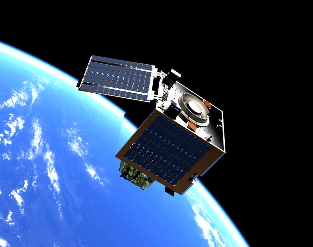
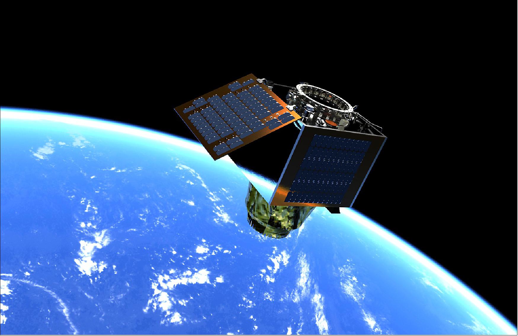
Satellite Vu’s MWIR satellite is based on SSTL’s DarkCarb satellite bus, a 100 kg microsatellite platform designed and built for rapid delivery at ultra-low cost. The spacecraft will fly a water propulsion system capable of providing more than 130 m/s ΔV, allowing traversal to lower orbits to gain a higher ground sample distance (GSD) as well as other orbital manoeuvers such as altitude maintenance or phasing. The water-based system reduces launch site handling costs and schedule, while the modular nature of the system creates flexibility as the number of tanks can be reduced depending on the customer’s needs.
Overview
The London-based startup company Satellite Vu is developing a MWIR (Mid Wave InfraRed) thermal imaging satellite which will pave the way for a planned constellation of seven MWIR spacecraft. The constellation will have the ability to measure the heat signature of any building anywhere on Earth multiple times a day, enabling real time insights into building emissions, energy use and insulation.
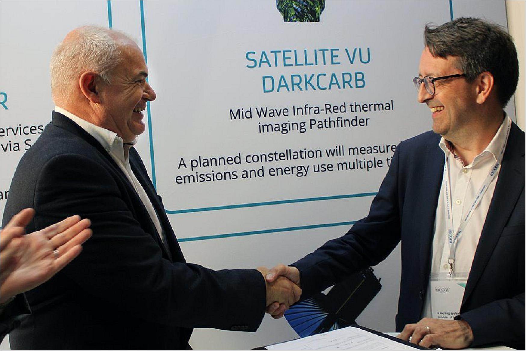
In December 2021, the companies SSTL (Surrey Satellite Technology Ltd) and Satellite Vu signed a contract for the development of the first MWIR satellite.1) SSTL’s Managing Director, Phil Brownnett, said “I am extremely pleased to be partnering with UK start up Satellite Vu. Our partnership is an ideal blend of SSTL’s pioneering approach and years of small satellite expertise with Satellite Vu’s entrepreneurial approach and strong business case. It’s a game-changing climate change mission and SSTL is very proud to be involved.”
The first MWIR satellite – or as Satellite Vu calls it, “the world’s thermometer” – is due for launch in June 2023, and will be the agency’s pathfinder mission for their constellation. The mission will collect thermal data regarding the Earth’s natural and built environment.
Satellite Vu’s CEO, Anthony Baker, said: “After months of careful planning and development, we’re excited to have formally signed this agreement with Surrey Satellite Technology Ltd to build the first of our seven planned satellites which will offer a view into temperatures across cities and around the world. Satellite Vu will become the thermometer of the world. With the climate change emergency reaching critical levels, our insights will enable any business, building owner or government on the planet to obtain an independent, ongoing assessment of their energy wastage, efficiency and including the ability to monitor water pollution. Getting access to this data will enable organisations to take immediate action to improve their green credentials, as well as giving shareholders and investors a unique view into their company’s environmental, social and governance (ESG) performance.”
Satellite Vu plans to launch a constellation of infrared satellites to monitor the heat emissions of any structure on Earth in near real-time to determine insights into economic activity, energy efficiency and carbon footprint. The satellites’ acquired data will provide invaluable insights into “greenwashing” – the process of companies supplying misleading information to customers about how their products are environmentally sound.
The MWIR satellite will have the ability to identify specific companies that are exaggerating their emission reduction efforts or are unaware of their building’s inefficiency. A high priority to reduce emissions will arise amongst companies, with use of city maps with different insight layers and 3D thermal models, Satellite Vu will help companies increase their energy efficiency. Satellite Vu’s infrared satellite imagery will eliminate the expensive and long process of assessing buildings manually, and provide information and insights quickly to aid in economical decarbonisation. While existing satellite technology can estimate carbon from large features such as wildfires or other greenhouse gas emissions like methane, the International Energy Agency (IEA) roadmap to Net Zero8) reports the energy efficiency of the built environment is far more important in the reduction of greenhouse gases than the reduction of methane emissions from the energy sector.
Satellite Vu’s deal with SSTL followed their £15 million series A funding round, plus an additional £1 million grant from the UK Space Agency’s National Space Innovation Programme (NSIP). Head of NSIP, Elizabeth Seaman, said: “The National Space Innovation Programme is supporting our most ambitious innovators who are developing first-of-a-kind technologies to help solve some of our greatest challenges. This exciting partnership between SSTL and Satellite Vu will develop the first of a series of new satellites to provide real-time data on the energy efficiency of buildings, an important source of information that will help organisations respond to climate change.”
Background
With the increasing availability of high spatial and temporal resolution Earth observation and remote sensing data, applications have grown rapidly. However, much of the available satellite imagery is captured in the visible spectrum and at either mid-morning or mid-afternoon local time due to the dependence of high illumination.
MWIR imagery overcomes this limitation as observations depend on temperature at the scene, enabling imaging at any local time, including at night. Thermal imaging will enable Satellite Vu’s constellation to differentiate between objects and surfaces of different temperatures and provide utility in the mapping of heat islands in urban areas, including the detection of buildings or installations emitting a significant level of heat. Other applications include detection of waste and pollution spills or discharge (assuming the pollutants are warmer than the surrounding water bodies), and assistance with disaster support activities for wildfires, volcanic eruptions and flooding.
The temperature data collected by Satellite Vu will pinpoint the worst energy wasting buildings so that planned and targeted investment in energy efficiency measures can be made based on measurement data. These observations will aid the UK Government’s 10-point plan for a ‘Green Industrial Revolution’, highlighting the challenge of greening homes and public buildings, as well as developing technologies to achieve new energy ambitions.
The latest Intergovernmental Panel for Climate Change (IPCC) report 9) stressed evidence of humans being the cause behind the 1.09°C global temperature increase – a “code red for humanity”. IPCC author Professor Piers Forster from the University of Leeds, UK, stated that near-term emission reduction can “really reduce the rate of unprecedented warming”, although the report fails to provide quantitative guidance and measurements resulting in uncertainty for the right first step for consumers and businesses towards the green recovery. The International Energy Agency states: “Energy efficiency is the ‘first fuel’ for achieving high ambition climate goals". 2)
Spacecraft
Satellite Vu’s first MWIR satellite is based on SSTL’s DarkCarb satellite bus, a 100 kg microsatellite platform from SSTL’s Carbonite series designed with a 3.5 m resolution MWIR imager with video capability.
The spacecraft will utilise a water propulsion system capable of providing more than 130 m/s ΔV, allowing traversal to lower orbits to gain a higher ground sample distance (GSD) as well as other orbital manoeuvers such as altitude maintenance or phasing. The water-based system reduces launch site handling costs and schedule, and the modular nature of the system creates flexibility as the number of tanks can be reduced depending on the customer’s needs.
SSTL’s Carbonite Satellite Range
SSTL’s Carbonite series are small, ultra low-cost, capable satellite platforms designed and built for rapid-delivery. Launched in 2015 and the first of the Carbonite series, Carbonite-1 demonstrated 1 m GSD high resolution imagery as well as video capability with a shortened delivery schedule. Carbonite-1 was built in only 6 months with extensive use of commercial off-the-shelf (COTS) components as well as commercial technology, protocols and processes, and SSTL’s automated production to demonstrate video imagery from space, opening new applications for the commercial space sector.
Launched in 2018 and the second technology demonstration mission in the Carbonite series, Carbonite-2 featured several new improvements and objectives to its predecessor. Carbonite-2’s data has been supplied to the UK’s Royal Air Force (RAF) for use by the Joint Force Command National Centre for Geospatial Intelligence to demonstrate how low cost data from small satellites can create and improve intelligence products used for strategic decision making, and to support Armed Forces operations and training. 1)
Launch
The first of Satellite Vu’s planned constellation is set to launch aboard a SpaceX Falcon 9 rocket in June 2023.
The second satellite is expected to be launched aboard another SpaceX Falcon 9 rocket in early 2024, to respond to market demand for greater capacity and more frequent revisit times.
Mission Status
- December 16, 2021: Satellite Vu signed a contract with SSTL to build its first satellite. Development of the satellite has been supported by the UK Space Agency, via two National Space Innovation Grants and a European Space Agency (ESA) General Support Technology Programme (GSTP) grant. 1)
- July 21, 2022: Satellite Vu commissioned a new clone of its original satellite in collaboration with SSTL to double its data collection capacity. The news comes after Satellite Vu recently completed their funding via the UKSA National Space Innovation Programme (NSIP), helping to implement de-risking technology and make significant operational improvements. 7)
- September 21, 2022: Satellite Vu became a supporter of the Terra Carta, the guiding mandate for the Sustainable Markets Initiative (SMI) in which Satellite Vu aims to align their operations with. 6)
- September 22, 2022: Satellite Vu signed a second launch contract with SpaceX for their second satellite, to launch aboard a Falcon 9 rocket in early 2024. 5)
- 28 September, 2022: Satellite Vu partnered with Viasat, operators of the Real-Time Earth global ground service network of world-class antenna systems to ensure rapid command, reception and dissemination of satellite imagery. Viasat will give Satellite Vu the capability for rapid and regular contact with its constellation to ensure maximum responsivity to customers for imagery tasking, low latency, and high-speed delivery of thermal imagery. 4)
- 22 November, 2022: Japan Space Imaging Corporation (JSI) signed a multi-million pound purchase with Satellite Vu’s Early Access Option Programme (EAOP), providing preferred access to satellite imagery, products and services, as well as the opportunity to secure satellite capacity to support their requirements. JSI is the leading provider of geospatial information including satellite data, serving both defence and intelligence customers as well as civil and commercial markets in Japan. With use of Satellite Vu’s MWIR imagery, JSI will expand their global imaging portfolio with high-resolution thermal data anywhere on Earth. Partners of the EAOP can influence the location of Satellite Vu’s sample data gathered by an aerial campaign. This will give partners access to Satellite Vu’s data ahead of the satellite’s launch. The EAOP also enables access to sample imagery during the commissioning phase from Satellite Vu’s delivery platform and API, while reserving satellite delivery capacity. 3)
Sensor Complement
MWIR (Mid Wave InfraRed) Imager
The instrument is designed and supplied by the Italian company Leonardo, and has an array of pixels on an 8 μm pitch – the smallest thermal MWIR pixels commercially available at the time of development. Video capability will provide unique advantages over standard MWIR imagery, allowing the capture of dynamic events such as 3D profiles, movement tracking, and speed measurement useful for a range of applications concerning defence and security as well as disaster monitoring. Funding for Satellite Vu’s MWIR imager was provided by the UK’s Centre for Earth Observation Instrumentation.
MWIR Instrument Flight Trials
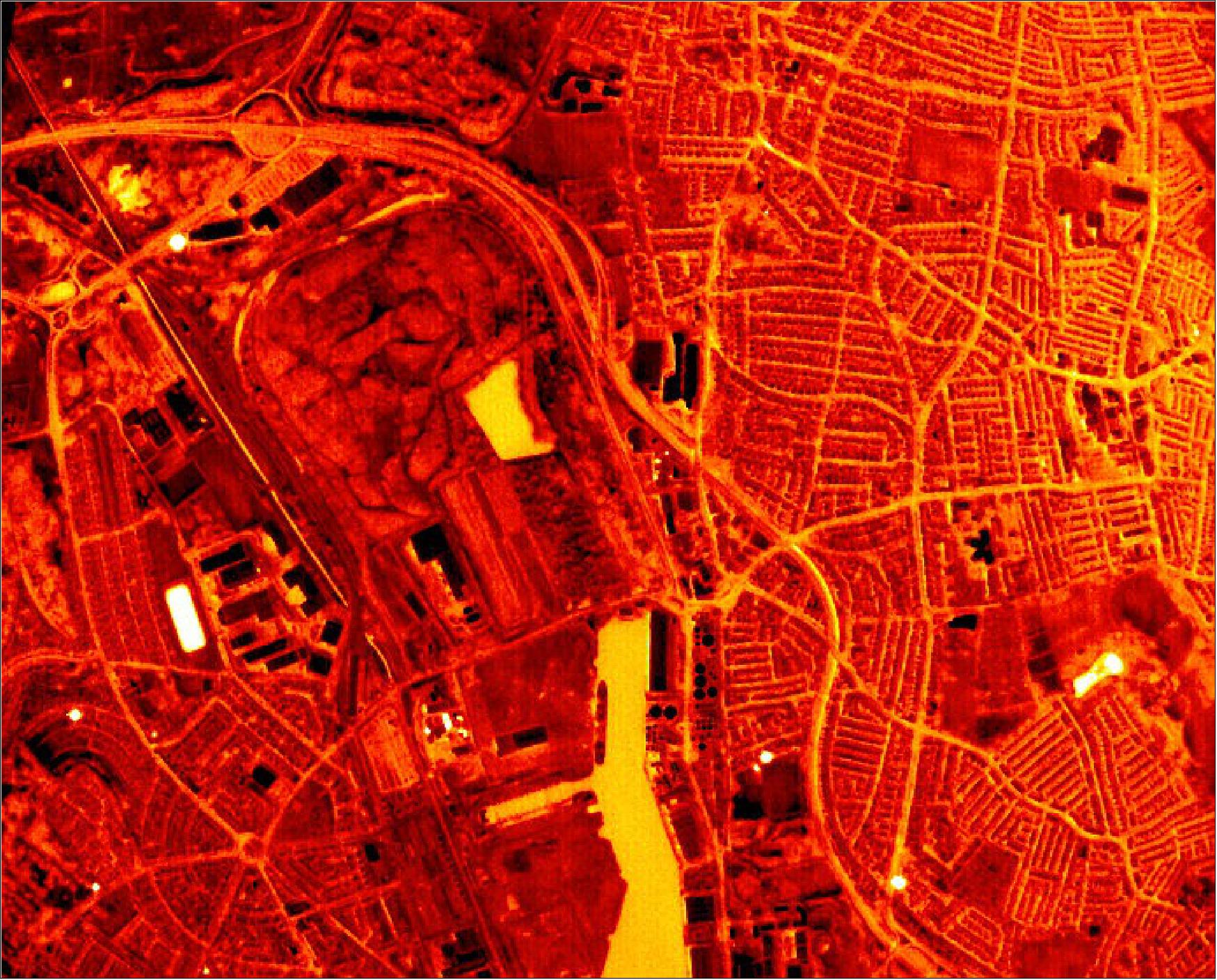
The instrument developed by SSTL has been systematically tested in flight trials on a light aircraft at 2400 m in altitude. Images were captured at night from an extended acquisition taken at a rate of 25 frames per second, and can be seen in Figures 3 & 4. Darker areas in the image are cool or have low emissivity, and brighter areas are warm and have higher emissivity. Image processing was performed to highlight detail in the colder areas for easier visual interpretation, resulting in a saturation of hotspots in the image.
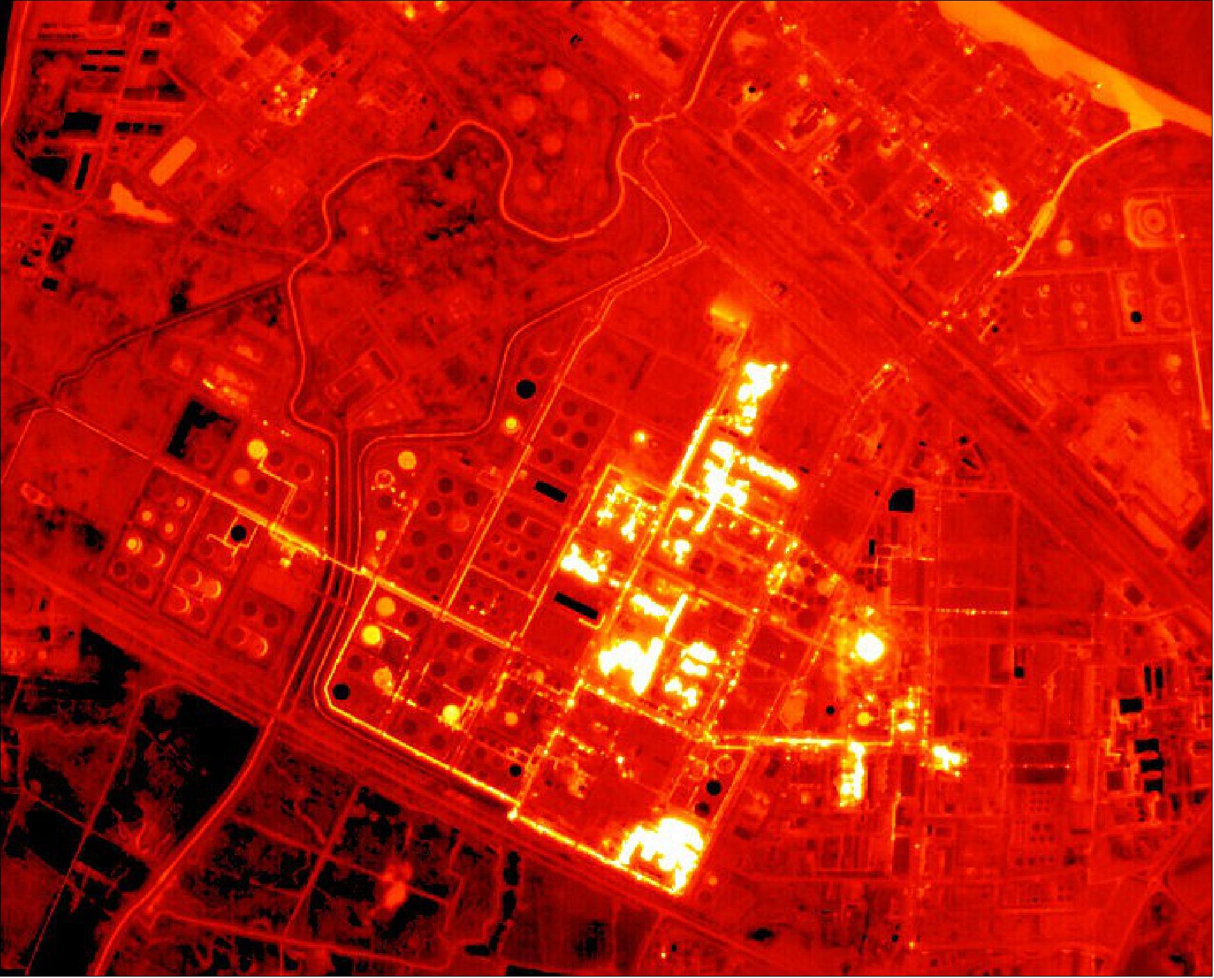
Figure 3 highlights areas of the Stanlow Refinery with higher emission of heat compared to other cooler (darker) areas. The two black rectangles near the image centre are buildings with low emissivity and heat loss compared to other areas with high emissivity. In the top right of the image, warm water from a side channel can be seen mixing with cooler river water. 1)
References
1) ”SSTL Signs Contract With Satellite Vu for Mid Wave Infra-Red Satellite,” SSTL Press Release, 16 December 2021, URL: https://www.sstl.co.uk/media-hub/latest-news/2021/sstl-signs-contract-with-satellite-vu-for-mid-wave
2) Tobias Reinicke, ”Satellite Vu confronts climate change, offering a solution for reducing carbon emissions,” Satellite Vu, 31 August 2021, URL: https://web.archive.org/web/20211011233726/https://www.satellitevu.com/press/satellite-vu-confronts-climate-change-offering-a-solution-for-reducing-carbon-emissions
3) Zena Holmes, “Japan Space Imaging Corporation signs up to Satellite Vu’s Early Access Option Programme,” Satellite Vu, 22 November 2022, URL: https://web.archive.org/web/20230517124638/https://www.satellitevu.com/press/japan-space-imaging-corporation-signs-up-to-satellite-vus-early-access-option-programme
4) Zena Holmes, “Satellite Vu partners with Viasat to ensure rapid service to customers,” Satellite Vu, 28 September 2022, URL: https://web.archive.org/web/20230406100806/https://www.satellitevu.com/press/viasat-partnership
5) Zena Holmes, “Satellite Vu signs second SpaceX launch contract to accelerate deployment of thermal monitoring capabilities from space,” Satellite Vu, 22 September 2022, URL: https://web.archive.org/web/20221205051306/https://www.satellitevu.com/press/satellite-vu-signs-second-spacex-launch-contract
6) Zena Holmes, “Satellite Vu becomes a supporter of the Terra Carta - Sustainable Markets Initiative,” Satellite Vu, 21 September 2022, URL: https://web.archive.org/web/20221004140448/https://www.satellitevu.com/press/satellite-vu-becomes-a-supporter-terra-carta-smi
7) “Satellite Vu and SSTL commission satellite clone to double climate data collection,” SSTL Press Release, 21 July 2022, URL: https://www.sstl.co.uk/media-hub/latest-news/2022/mwir-constellation-satvu
8) IEA (2021), Net Zero by 2050, IEA, Paris https://www.iea.org/reports/net-zero-by-2050, License: CC BY 4.0
9) IPCC, 2022: Climate Change 2022: Mitigation of Climate Change. Contribution of Working Group III to the Sixth Assessment Report of the Intergovernmental Panel on Climate Change [P.R. Shukla, J. Skea, R. Slade, A. Al Khourdajie, R. van Diemen, D. McCollum, M. Pathak, S. Some, P. Vyas, R. Fradera, M. Belkacemi, A. Hasija, G. Lisboa, S. Luz, J. Malley, (eds.)]. Cambridge University Press, Cambridge, UK and New York, NY, USA. doi: 10.1017/9781009157926
The information compiled and edited in this article was provided by Herbert J. Kramer from his documentation of: "Observation of the Earth and Its Environment: Survey of Missions and Sensors" (Springer Verlag) as well as many other sources after the publication of the 4th edition in 2002. - Comments and corrections to this article are always welcome for further updates (eoportal@symbios.space).