IRS (Indian Remote Sensing Satellites)
EO
Atmosphere
Ocean
Cloud type, amount and cloud top temperature
The IRS was a series of optical imaging satellites operated by the ISRO. The first IRS was launched in 1988, and continued to observe and manage India’s natural resources until 2019.
Quick facts
Overview
| Mission type | EO |
| Agency | ISRO |
| Mission status | Mission complete |
| Launch date | 17 Mar 1988 |
| End of life date | 01 Jan 1994 |
| Measurement domain | Atmosphere, Ocean, Land, Snow & Ice |
| Measurement category | Cloud type, amount and cloud top temperature, Ocean colour/biology, Aerosols, Multi-purpose imagery (land), Vegetation, Albedo and reflectance, Landscape topography, Snow cover, edge and depth |
| Measurement detailed | Ocean chlorophyll concentration, Aerosol optical depth (column/profile), Cloud type, Aerosol Extinction / Backscatter (column/profile), Land surface imagery, Aerosol effective radius (column/profile), Vegetation type, Earth surface albedo, Land surface topography, Snow cover |
| Instruments | MOS, LISS-I, LISS-II, WiFS, X-ray astronomy payload |
| Instrument type | Imaging multi-spectral radiometers (vis/IR), High resolution optical imagers, Other |
| CEOS EO Handbook | See IRS (Indian Remote Sensing Satellites) summary |
Summary
Mission Capabilities
The first IRS, IRS-1A, was nearly identical to its successor, IRS-1B. Both had three high-resolution optical imagers onboard, all multispectral cameras: LISS-I (Linear Imaging Self Scanner) and two LISS-II. The next in the series was IRS-1E/P1, which was equipped with LISS-I and a single spectral band camera MEOSS (Monocular Electro-Optical Stereo Camera). However, IRS-1E/P1 failed to reach orbit. Its replacement was IRS-P2, which had two modified LISS-II onboard.
The IRSs were all built to monitor soil, crops, forests and land use.
Performance Specifications
LISS-I had four spectral bands: blue, green, red, and near-infrared (NIR). Each band had a spatial resolution of 72.5 m and a swath width of 148 km. LISS-II had the same four spectral bands but with a resolution of 36.25 m and a swath of 2 m x 74 m, while the modified LISS-II had a resolution of 32 m x 37 m and a swath of 131 km. MEOSS was a single spectral band spanning 0.57 µm - 0.7 µm, with a resolution of 50 m x 158 m and a swath of 510 km.
IRS-1A and 1B maintained a sun-synchronous orbit with an altitude of 904 km, an inclination of 99.08°, and a repeat cycle of 22 days. IRS-P2 was similarly in a sun-synchronous orbit with an altitude of 904 km, but with an inclination of 98.68° and a repeat cycle of 24 days.
Space and Hardware Components
Neither IRS-1A, IRS-1B or IRS-P1 contained data storage capabilities and thus provided real-time downlink services. IRS-1A and 1B provided downlink from LISS-I in S-band at a rate of 5.4 Mbit/s, and downlink from each LISS-II in X-band at a rate of 10.4 Mbit/s. Telemetry, Tracking, and Command (TT&C) transferred data via VHF (Very High Frequency). Similarly, IRS-P2 provided each LISS-II downlink in X-band, and TT&C operated in S-band.
IRS-1A launched in March 1988 and operated until January 1994, while IRS-1B operated from August 1991 to August 2002. IRS-1E/P1 launched in September 1993 and failed to achieve orbit, however, IRS-P2 successfully launched and operated from October 1994 until December 1997. Successors of this series include IRS-1C, -1D, -P3, -P4, -P5 (CARTOSAT-1), and -P6 (RESOURCESAT-1).
|
IRS (Indian Remote Sensing Satellites) - Overview and early LEO Program of ISRO
Following the successful demonstration flights of Bhaskara-1 and Bhaskara-2 - experimental Earth observation satellites developed and built by ISRO (Indian Space Research Organization) - and launched respectively in 1979 and 1981, India began the development of an indigenous IRS (Indian Remote Sensing Satellite) program. India soon realised that sustaining its space program in the long run would depend on indigenous technological capabilities, particularly in the context of US export restrictions.
Therefore, in addition to building satellites, India also undertook satellite launch vehicle development in the early 1970s. As a consequence, India has two launch systems at the start of the 21st century, namely PSLV (Polar Satellite Launch Vehicle) and GSLV (Geosynchronous Satellite Launch Vehicle). 1)
IRS was the integrated LEO (Low Earth Orbit) element of India's NNRMS (National Natural Resources Management System) with the objective to provide a long-term spaceborne operational capability to India for the observation and management of the country's natural resources (applications in agriculture, hydrology, geology, drought and flood monitoring, marine studies, snow studies, and land use).
The intent of the program was to create an environment of new perspectives for the Indian research community as a whole, to stimulate the development of new technologies and applications, and to utilize the Earth resources in more meaningful ways.
The IRS program started in the mid 1980s. Eventually, a continuous supply of synoptic, repetitive, multispectral data of the Earth's land surfaces was obtained (similar to the US Landsat program). In 1995, IRS imagery was made available to a larger international community on a commercial basis. The availability of Landsat imagery generated interest in the science community. The Hyderabad ground station started receiving Landsat data on a regular basis in 1978. The Landsat program served as a model for the IRS program.
The initial program of Earth-surface imaging was extended by the addition of sensors for complementary environmental applications. This started with the IRS-P3 satellite which is flying MOS (Multispectral Optoelectronic Scanner) for the measurement of ocean color. The IRS-P4 mission is dedicated to ocean monitoring. 2) 3) 4)
The first generation satellites IRS-1A and 1B were designed, developed and launched successfully during 1988 and 1991 with multispectral cameras with spatial resolutions of 72.5 m and 36 m, respectively. These early satellites were launched by Russian Vostok boosters from the Baikonur Cosmodrome. Subsequently, the second generation remote sensing satellites IRS-1C and -1D with improved spatial resolutions have been developed and successfully launched in 1995 and 1997, respectively. IRS-1C/1D data has been used for cartographic and town planning applications.
Satellite | Launch date | Sensor complement | Spectral Bands (µm) | Spatial resolution (m) | Swath width (km) | Repeat cycle (days) |
IRS-1A | 17.03.1988 | LISS-I, and LISS-II A/B | 0.45-0.52 | 72.5 m LISS-I | 148 | 22 |
IRS-1B | 29.08.1991 | LISS-I and LISS-II A/B | same as for IRS-1A |
| 148 | 22 |
IRS-P2 | 15.10.1994 | LISS-II M | 0.45-0.52 | 32 m x 37 m | 66 x 2 | 24 |
IRS-1C | 28.12.1995 | LISS-III | 0.52-0.59 | 23.5 | 142 | 24 |
PAN | 0.50-0.75 | 5.8 | 70 | 24 (5) | ||
WiFS | 0.62-0.68 | 188 | 804 | 5 | ||
IRS-P3 | 21.03.1996 | WiFS | 0.62-0.68 | 188 | 804 | 5 |
MOS-A | 0.75-0.77 | 1500 | 195 | Ocean surface | ||
IXAE | Indian X-ray Astronomy Experiment | |||||
IRS-1D | 29.09.1997 | Satellite and instruments are identical to those of IRS-1C | ||||
IRS-P4 (OceanSat-1) | 26.05.1999 | OCM | 0.4-0.9 | 360 x 236 | 1420 | 2 |
IRS-P6 | 17.10.2003 | LISS-IV | 0.52-0.59 | 5.8 | 70 | 24 (5) |
LISS-III* | 0.52-0.59 | 23.5 | 140 | 24 | ||
AWiFS | 0.62-0.68 | 70 | 740 | 5 | ||
IRS-P5 | 05.05.2005 | PAN-F | 0.50-0.75 | 2.5 | 30 | 2-line stereo camera |
CartoSat-2 | 10.01.2007 | PAN camera | 0.50-0.85 | < 1 | 9.6 |
|
OceanSat-2 | 23.09.2009 | OCM | 0.40-0.90 8 bands | 360 x 236 | 1420 | 2 |
RISAT | 2011 | SAR instrument | 5.350 GHz (C-band) | < 2 m to 50 m | 100 - 600 |
|
Megha | 2011 | MADRAS | 5 chan. radiometer | 40 km x 60 km | 1700 | 2 |
SARAL | 2011 | AltiKa | 35.75 GHz Ka-band altimeter | |||
IRS-1A (Indian Remote Sensing Satellite-1A)
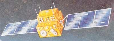
The spacecraft bus is box-shaped (1.6 m x 1.6 m x 1.5 m) with two solar panels (8.6 m2) as shown in Figures 1 and 4. The S/C structure is made of aluminum/aluminum honeycomb. The satellite is three-axis stabilized utilizing a zero momentum system. Hydrazine thrusters (80 kg fuel) are also used for control and momentum dumping.
The IRS series satellites are built around a zero-momentum reaction wheel based system.
Gyro-based attitude reference using quaternion propagation with attitude updates from Earth sensors and sun sensors (CCD-based is used for yaw angle measurements) provide the high-pointing accuracy and stability required for the imaging payload. Attitude is sensed by Earth sensor, sun sensor, star sensor and dynamically tuned gyros. The actuators are reaction wheels (4), magnetic torquers, and hydrazine thrusters (sixteen 1-newton thrusters). The spacecraft had a pointing accuracy of 0.3º in pitch/roll and 0.5º in yaw, an attitude determination accuracy of ±0.1º, a total mass of 975 kg (at launch), and 700 W of power. Deployable solar panels provided power in sunlight and two NiCd batteries (40 Ah) provided power for the eclipse phase of the orbit. The mission's design life was three years. 5) 6)

Launch
March 17, 1988 on a Russian launch vehicle Vostok-2M from the Baikonur Cosmodrome, Kazhakstan.
Orbit
IRS-1A flew in a Sun-synchronous orbit with nominal altitude of 904 km, an inclination of 99.049º, a period of 103.2 minutes, a repeat cycle of 22 days, and an equator crossing at 10:26 hours on descending node.
The mission had applications in land use, agriculture, forestry, hydrology, soil classification, coastal wetland mapping, natural resources (in particular pinpointing likely groundwater locations), disaster monitoring, and cartography.
RF communications included payload downlink in S-band and X-band. The satellite carried a real time LISS-2A/B data downlink in X-band with a transfer rate of 10.4 Mbit/s (2 links). The data was downlinked to a 10 m dish antenna at Shadnagar on 20 W. The LISS-I data downlink was on 5 W S-band at a rate of 5.4 Mbit/s. There was no onboard recorder and the payload data were PCM/BPSK modulated.
The IRSO S/C control center is in Bangalore. TT&C function is provided by ISTRAC (ISRO Tracking Network), supported by DLR (GSOC, Weilheim), NOAA (Fairbanks), ESA (Malindi) and the USSR (Bearslake) ground stations.
Mission Status
Spacecraft operations were ended in 1992.
Sensor Complement
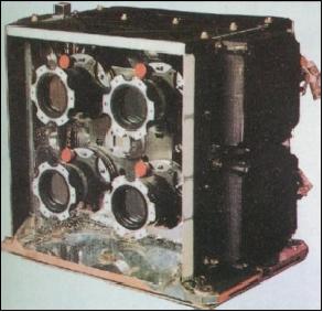
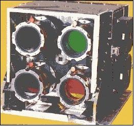
LISS-I, -II (Linear Imaging Self-Scanning Sensor)
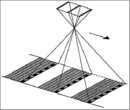
LISS-I and LISS-2 with a total of three cameras. LISS-I and LISS-II are two multispectral camera assemblies, each with a different resolution providing a swath of about 150 km. Each LISS camera consists of the collecting optics, imaging detectors, inflight calibration system, the processing electronics, and data formatting electronics.
LISS-I employs four 2048-element linear CCD detector arrays with spectral filters (Fairchild CCD 143A). All cameras use refractive type collecting optics with spectral selection by appropriate filters. The refractive optics were chosen to obtain a large FOV (Field of View). A lens assembly for each spectral band is used for better performance and effective utilization of the full dynamic range of the CCDs. Two LEDs (Light Emitting Diodes) per band are provided for inflight calibration.
A LISS-I scene is 148 km x 174 km. The LISS-II A/B assembly features eight 2048-element linear CCD detector arrays with spectral filters (2 parallel swaths of 74 km each for the LISS-II A/B assembly with 3 km overlap, the total swath is 145 km). Four LISS-II scenes cover the area of one LISS-I scene. 7) 8) 9) 10)
Parameter | LISS-I | LISS-II A/B |
Focal length | 162.2 mm | 324.4 mm |
FOV, IFOV | 9.4º, 80 µrad | 4.7º+ 4.7º, 40 µrad |
Spectral bands (µm) | 0.46 - 0.52 (blue) | 0.46 - 0.52 (blue) |
Integration time | 11.2 ms | 5.6 ms |
Ground resolution | 72.5 m (each band) | 36.25 m (each band) |
Swath width | 148 km | 2 x 74 km |
Radiometric resolution | 7 bit | 7 bit |
Detector, elements | CCD, 2048 | CCD, 2048 |
Data rate | 5.2 Mbit/s | 2 x 10.4 Mbit/s |
Instrument mass, power | 38.5 kg, 34 W | 2 x 80.8 kg, 2 x 34 W |
IRS-1A data products are being acquired, processed and disseminated by NRSA (National Remote Sensing Agency) Data Center, Hyderabad. These data products compete directly with Landsat TM and MSS data as well as with SPOT Image data on the market.
IRS-1B (Indian Remote Sensing Satellite-1B)
IRS-1B is a follow-up satellite of IRS-1A. The IRS-1B spacecraft and instruments are practically identical with those of IRS-1A (satellite mass = 975 kg).
Launch
Launch of the S/C was by a Russian Vostok-2M vehicle from Baikonur on August 29, 1991 (same tracking support configuration as for IRS-1A).
Orbit
Polar sun-synchronous orbit; altitude = 904 km, inclination = 99.09º, period = 103.2 minutes. Repeat cycle: 22 days.
ISRO's policy allows ground stations from other countries to have direct access to the Indian satellite imagery. Any existing ground station equipped to receive data from SPOT or from Landsat will be able to receive IRS-1B satellite data with very minor changes (ISRO can supply the upgrade). 11) 12)
Mission Status
The IRS-1B satellite outlived its design live of 3 years - being operational on its 10th anniversary after launch (August 29, 2001). 13)
Afterwards, the S/C was being used for conducting various experiments including studying the design margins of the various subsystems and to test different modes of operation using the available fuel.
IRS-1E (Indian Remote Sensing Satellite-1E), (P1)
A technological mission with the primary objective to test an ISRO-developed launch vehicle by the name of PSLV-D1 (Polar Satellite Launch Vehicle-Developmental flight 1). The IRS-1E spacecraft is a modified IRS-1A engineering model. 14)
Launch
The launch occurred on Sept. 20 1993 from SHAR (Sriharikota Launching Range, Andhra Pradesh, ISRO's main launch site, India, located on India's east coast at 13.57º N, 80.293º E, about 100 km north of Chennai). Unfortunately, the satellite failed to achieve orbit (PSLV failure of 2nd stage, a newly developed launch vehicle of ISRO - the PSLV control software prevented attaining orbit). The mission ended in the ocean.
Orbit
Sun-synchronous polar orbit with equatorial crossing at 10:30 AM on descending node, altitude = 904 km, period = 103 min, repeat cycle = 22 days.
Sensor Complement
LISS-I (Linear Imaging Self-Scanning System)
Same definition as under IRS-1A.
MEOSS (Monocular Electro-Optical Stereo Scanner)
MEOSS is a DLR (Germany) experimental sensor with pushbroom CCD technology. MEOSS is a stereo camera system capable of recording three images simultaneously with a single lens by means of linear scanning (3-line stereo system). MEOSS has a single lens with a focal length of 61.6 mm and 3 CCD line sensor arrays. Each CCD array comprises 3236 sensor elements with 10.7 µm in size. The scanner operates in the spectral range of 0.57-0.7 µm. Resolution = 50 m along track, 158 m in cross-track, 45 m in vertical direction; swath width = 510 km, 8 bit quantization. Application: stereo view capability to study topography, geology, terrain analysis and modeling, snow/ice mapping, meteorology (cloud height and movement), etc. 15) 16) 17) 18)
The MEOSS concept had already been demonstrated on an airborne platform of DLR in 1986 and in 1989. Prior to the IRS-1E flight, MEOSS was also launched on the SROSS-2 (Stretched Rohini Satellite Series) mission of ISRO (July 13, 1988 on ISRO's ASLV launcher). However, SROSS-2 experienced also a launcher failure.
Number of linear CCD arrays | 3 |
Nominal focal length nadir/stereo | 61.6 mm |
CCD element size | 10.7 µm |
Number of active pixels per array nadir/stereo | 3236 |
Stereo angle | ±23.5º |
IRS-P2 (Indian Remote Sensing Satellite-P2)
An ISRO mission with the objective to acquire remote sensing data for oceanographic, land, and atmospheric applications (demonstration of the IRS-1C/1D bus). The spacecraft is three-axis stabilized using conically scanning Earth sensors and dynamically tuned gyros for attitude sensing, and reaction wheels, magnetic torquers and monopropellent hydrazine thrusters as actuators. Inertial attitude referencing with the star sensor updates is one of the major ISRO developments for astronomical X-ray observations. The attitude control system of IRS-P2 provides multipurpose functions by pointing for remote sensing, and inertial pointing for the X-ray observations. S/C mass = 870 kg, solar power = 510 W, two 21 Ah NiCd batteries. 19)
Launch
October 15, 1994 from SHAR (Sriharikota Launching Range) with a PSLV-D2 launcher. A major objective of this launch was to demonstrate/qualify the newly developed launch vehicle PSLV (Polar Satellite Launch Vehicle) of ISRO. This time around, the PSLV functioned correctly, allowing IRS-P2 to assume its orbit.
Orbit
Sun-synchronous circular orbit with an equatorial crossing at 10:30 AM descending node, altitude = 817 km, inclination = 98.7º, repeat cycle = 24 days, period = 101.35 min.
RF communications: No onboard data storage capability. Downlink broadcast of R/T science data in X-band (8.316 GHz, PCM/QPSK/PM modulation, data rate = 2 x 10.4 Mbit/s) to a dedicated ground station network and to a general user community. TT&C operations in S-band.
Mission Status
The IRS-P2 spacecraft continued in operations until September 1997. 20)
Sensor Complement
LISS-IIM (Linear Imaging Self-Scanning System-II Modified)
Same definition as under IRS-1A. The LISS-IIM instruments (there are two just as LISS-II A/B) are realized with a single optical feed utilizing the full ±5º FOV (there are 4 lenses in one optical head). The instrument employs pushbroom scanning and a linear CCD line detector array with 4 spectral bands in VNIR (0.45-0.52 µm, 0.52-0.59 µm, 0.62-0.68 µm, 0.77-0.86 µm. Focal length = 324.4 mm. The ground resolution is 32 m (cross-track) x 37 m (along-track). The combined swath is 131 km. The instrument mass is 80.8 kg (x 2), the instrument power is 34 W (x 2).
References
1) P. Kumar Sangatramani, K. Sangatramani, “India in Space - 2020,” 2003, https://web.archive.org/web/20150405205658/http://www.bharat-rakshak.com/MONITOR/Space%20Essay/entry5.htm
2) G. Joseph, B. L. Deekshatulu, “Evolution of Remote Sensing in India,” Space in Pursuit of New Horizon, National Academy of Sciences publication, (editor: R. K. Verma and others), Allahabad, 1992, pp. 331-354
3) K. Kasturirangan, G. Joseph, et al., “IRS Mission,” Current Science, Vol. 61, No. 3 and 4, Aug. 25, 1991, pp. 136-151
4) P. S. Goel, “Spacecraft Technology Development in India,” Space Forum, Vol. 5, No 1-3, 2000, pp. 5-38
5) “Indian Remote Sensing Satellite and Associated Data Products,” A.K.S. Gopalan, Proceedings of the Twenty-Third International Symposium of Remote Sensing of the Environment, Vol. I, p. 71, ERIM, Ann Arbor, MI, 1990
6) IRS NewsLetter, ISRO, Vol. 2 No. 1, March 1991
7) G. Joseph, IRS-1A Camera - Its Evolution and Realization,” brochure of NNRMS (National Natural Resources Management System), Bangalore, India
8) Note: At the time of project initiation, CCD arrays with maturity of production were limited to 2048 elements. Hence the swath of LISS-I was limited to about 150 km. Since LISS-II has a better resolution by a factor of two compared to the LISS-I camera, two LISS-II cameras were needed to produce a swath similar to that of LISS-I.
9) J. Kirshnamurthy, A. S Padmavathy, V. Jayaraman, Uday Raj, “Inter Sensor Comparison of Indian Remote Sensing Satellite - 1A Linear Imaging Self Scanning Sensors for Radiometric behavior,” ACRS (Asian Conference on Remote Sensing) 1991, Oct. 30-Nov. 5, 1991, Singapore, http://www.gisdevelopment.net/aars/acrs/1991/mapfs/mapfs04pf.htm
10) http://www.csre.iitb.ac.in/isro/irs-1b.html
11) “India Expands Access to Imagery,” Space News Aug. 26 - Sept. 8, 1991, p. 22
12) “India Calls IRS-1B Launch a Success,” Space News, September 9-15, 1991, p. 12
13) “IRS-1B Completes 10 years of Remote Sensing Mission,” Aug. 29, 2001, URL: [web source no longer available]
14) Note: The satellite designations P1, P2, P3, etc. stand for the launches carried out by the PSLV (Polar Satellite Launch Vehicle), the launch vehicle developed by ISRO
15) IRS-1E MEOSS Utilization Plan, ISRO, July 1991
16) F. Lanzl, “The Monocular Electro-Optical Stereo Scanner (MEOSS) satellite experiment,” ISPRS Vol. 26-I, pp. 617-620, Stuttgart, 1986
17) M. Lehner, “Triple stereoscopic imagery simulation and digital image correlation for Monocular Electro-optical Stereo Scanner (MEOSS) project,” ESA Proceedings of the International Symposium on Progress in Imaging Sensors, Nov. 1986, pp. 477-484 (SEE N87-24738 18-43)
18) F. Lanzl, “The Monocular Electro-optical Stereo Scanner (MEOSS) satellite experiment,” 38th IAF (International Astronautical Congress), England, Oct. 10-17, 1987
19) Document on Configuration of IRS-P2 and MOS and their Interfaces, ISAC, Bangalore, Nov. 1992
20) http://database.eohandbook.com/database/missionsummary.aspx?missionID=234