GOSAT-GW (Global Observing SATellite for Greenhouse gases and Water cycle)
EO
JAXA
Atmosphere
Ocean
The Global Observing SATellite for Greenhouse gases and Water cycle (GOSAT-GW) is a Japanese Earth observation satellite that is a collaboration between the Japanese Ministry of Environment (MOE), National Institute for Environmental Studies (NIES) and the Japanese Aerospace Exploration Agency (JAXA). The mission, which is planned to launch in 2024, will aid in the understanding of the rate of climate change by monitoring greenhouse gases in the atmosphere, as well as improve our understanding of the water cycle which is essential for Numerical Weather Prediction (NWP).
Quick facts
Overview
| Mission type | EO |
| Agency | JAXA, MOE (Japan), NIES (Japan) |
| Mission status | Approved |
| Measurement domain | Atmosphere, Ocean, Land, Snow & Ice |
| Measurement category | Liquid water and precipitation rate, Atmospheric Temperature Fields, Cloud particle properties and profile, Vegetation, Surface temperature (ocean), Atmospheric Humidity Fields, Ozone, Trace gases (excluding ozone), Sea ice cover, edge and thickness, Soil moisture, Snow cover, edge and depth, Ocean surface winds |
| Measurement detailed | Atmospheric pressure (over sea surface), Precipitation intensity at the surface (liquid or solid), Cloud liquid water (column/profile), Atmospheric specific humidity (column/profile), O3 Mole Fraction, Sea surface temperature, CH4 Mole Fraction, Sea-ice cover, Soil moisture at the surface, Wind speed over sea surface (horizontal), Snow water equivalent, CO2 Mole Fraction, CO Mole Fraction, Atmospheric pressure (over land surface), HDO (column/profile), Chlorophyll Fluorescence from Vegetation on Land |
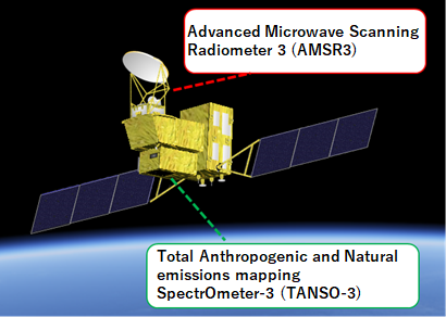
| Instruments | AMSR3, TANSO-3 |
| Instrument type | Atmospheric chemistry, Imaging multi-spectral radiometers (passive microwave) |
| CEOS EO Handbook | See GOSAT-GW (Global Observing SATellite for Greenhouse gases and Water cycle) summary |
Summary
Mission Capabilities
GOSAT-GW will carry two instruments onboard: the Total Anthropogenic and Natural emissions mapping SpectrOmeter-3 (TANSO-3), and the Advanced Microwave Scanning Radiometer 3 (AMSR3). TANSO-3 is a high-resolution nadir-scanning infrared spectrometer which will monitor whole-atmosphere monthly mean concentrations of greenhouse gases while AMSR3 is a multi-spectral imaging radiometer which will help to understand water cycle variation and its impact on climate change, as well as improving NWP.
Performance Specifications
TANSO-3 will have two imaging modes: Focus Mode, with a spatial resolution of 1-3 km at a swath width of 90 km, and Wide Mode, with a spatial resolution of 10 km and a swath width of 911 km. It will measure in three spectral bands, 0.45 μm and 0.7 μm at a spectral resolution less than 0.5 nm, and 1.6 μm at a spectral resolution less than 0.2 nm corresponding to carbon dioxide, methane and nitrogen dioxide absorption spectra respectively.
AMSR3 measures in 10 channels between 6.925 GHz and 183.3 GHz with a bandwidth ranging from 200 MHz to 4000 MHz depending on the frequency. It will have a swath width of 1535 km and its spatial resolution, which will also depend on the frequency, will range from 3 km x 5 km to 34 km x 58 km.
GOSAT-GW will be in a sun-synchronous orbit at an altitude of 666 km with a repeat cycle of three days. It will be in an ascending orbit with an inclination of 98.06°.
Space and Hardware Components
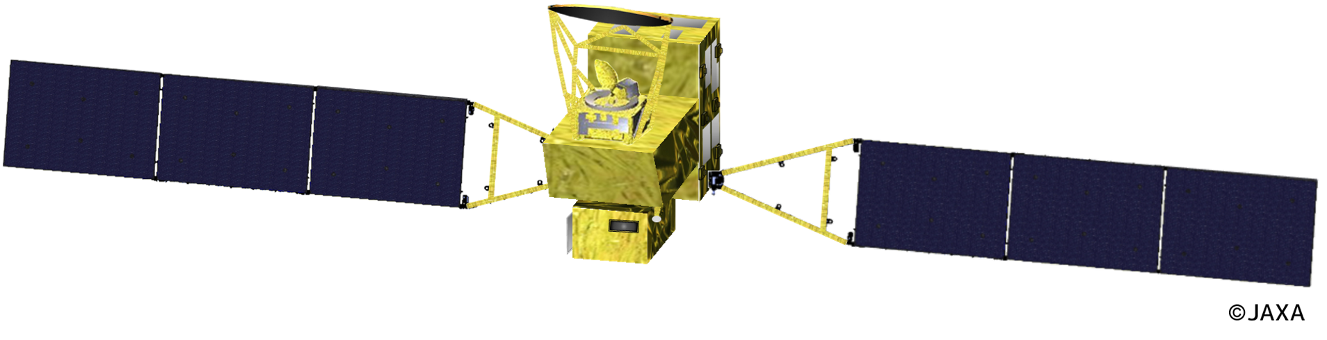
GOSAT-GW will be constructed by the Mitsubishi Electric Corporation under contract by JAXA. It will be a medium sized spacecraft with a mass of roughly 2900 kg and a power generation capability of 5.0 kW.
Overview
The Global Observing SATellite for Greenhouse gases and Water cycle (GOSAT-GW) is a Japanese Earth observation satellite that is responsible for the Greenhouse Gases Observing Mission, led by the Ministry of the Environment (MOE) and the National Institute for Environmental Studies (NIES), and the Water Cycle Change Observing Mission led by the Japanese Aerospace Exploration Agency (JAXA). It is the third satellite in the GOSAT series for observations of Greenhouse gases (GHGs), such as carbon dioxide and methane, from space, and is a successor to the Greenhouse gases Observing SATellite (GOSAT), launched in 2009, and GOSAT-2, launched in 2018. GOSAT-GW is scheduled to be launched in 2024. 1)
Spacecraft
The GOSAT-GW satellite will be a medium-sized spacecraft with a power generation capability of 5.0 kW. It will have a mass of roughly 2900 kg. 1)
The Mitsubishi Electric Corporation has been contracted by JAXA to construct the spacecraft.
Launch
The satellite is planned to launch in March 2024 by the H-IIA rocket from Tanegashima Space Centre. 1)
Orbit: The satellite will be in a sun-synchronous orbit at an altitude of 666 km with a repeat cycle of three days. It will be in an ascending orbit with an inclination of 98.06 and local solar time of 13:30. 3)
Mission Status
- December 2019: The GOSAT-GW project was started after 16 months of internal reviews on the system requirements and mission definitions. 3)
- March 30, 2020: Mitsubishi Electric Corporation announced that it has been designated by JAXA as the contractor of GOSAT-GW and has already initiated development activities. 6)
- October 2021: Based on the results of the critical design and development tests, the AMSR3 CDR was held, and the flight model is now being manufactured and tested. 2)
- April 26, 2022: The official GOSAT-GW website was launched. 1)
- December 27, 2022: The planned launch year of GOSAT-GW has been changed from JFY 2023 to 2024. 1)
Sensor Complement
The satellite will carry two instruments: the Total Anthropogenic and Natural emissions Spectrometer (TANSO-3) and Advanced Microwave Scanning Radiometer 3 (AMSR3). 1)
Total Anthropogenic and Natural emissions mapping SpectrOmeter-3 (TANSO-3)
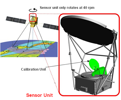
GOSAT-GW will carry a grating imaging spectrometer named TANSO-3. In contrast to the instruments on GOSAT and GOSAT-2, which were Fourier Transform Spectrometers (FTS), gratings were chosen instead of FTS to realise imaging of greenhouse gas concentrations with a smaller footprint and a wider swath than FTS which is necessary for emission source observations. 1)
The TANSO-3 instrument and its ground systems are being jointly developed by the Japanese Ministry of the Environment (MOE) and the National Institute for Environmental Studies (NIES). JAXA is also involved in the development and operation of TANSO-3 under a contract with MOE.
TANSO-3 has three mission objectives which will contribute to the mitigation of climate change driven by the increase of Greenhouse gases (GHGs) in the Earth’s atmosphere:
- To monitor whole-atmosphere monthly mean concentrations of carbon dioxide.
- To validate national anthropogenic GHG inventories reported by each country.
- To monitor large emission sources of GHGs such as urban areas, power plants, and permafrost.
TANSO-3 will observe carbon dioxide (CO2) and methane (CH4), two major greenhouse gases, and nitrogen dioxide (NO2). The NO2 information will be utilised to locate CO2 emission sources by fossil fuel burning and obtain the precise shape of plumes emitted from the sources. TANSO-3 will have three spectral bands: Band 1 at around 0.45 µm for NO2, Band 2 at around 0.76 µm for O2, and Band 3 at around 1.6 µm for CO2 and CH4. These gases cause distinct absorption features in the sunlight reflected at the land or ocean surface and observed by TANSO-3. Through the detailed characterization of these physical features using mathematical methods such as "optimal estimation," the column abundances of these gases (CO2 and CH4) and surface pressure will be obtained. These data will be finally converted to column-averaged dry-air mole fractions of CO2 and CH4 (known as XCO2 and XCH4, respectively). The column amount of NO2 will be calculated from the conventional Differential Optical Absorption Spectroscopy (DOAS) approach. Bands 1 and 2 will also be used for cloud detection. Solar Induced chlorophyll Fluorescence (SIF), an important indicator of photosynthetic activity of the terrestrial vegetation, will be obtained from Band 2 data. 1)
TANSO-3 will observe sunlight reflection when the satellite is on the dayside of Earth. During the nighttime, TANSO-3 will collect calibration data occasionally.
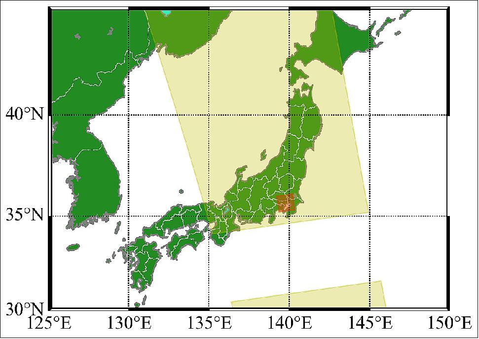
TANSO-3 will have two imaging modes: Wide Mode and Focus Mode. The characteristics of these modes are shown in table 1. It will be a nadir-scanning push-broom type spectrometer with its footprint size of 10 km and swath of 911 km.
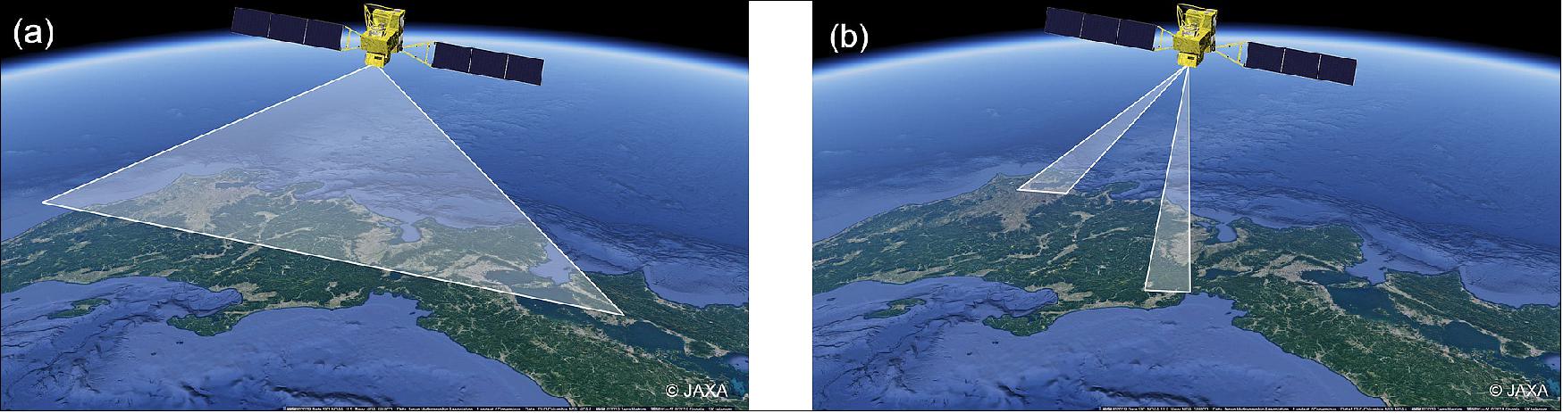
The default observation mode of TANSO-3 will be Wide Mode, whereas Focus Mode observation will be made based on observation requests from specific users. Focus Mode observations are expected to target urban regions and large emission sources such as power plants and oil/gas facilities, in addition to validation sites. TANSO-3 will have optional imaging capabilities in Focus Mode with smaller footprint sizes. 1)
Parameter | Focus Mode | Wide Mode |
Major Observation Targets | CO2, CH4, NO2 | |
Spectral bands | 0.45 μm, 0.7 μm, 1.6 μm | |
Spectral resolution | <0.5 nm @ 0.45 μm, <0.5 nm @ 0.7 μm, <0.2 nm @ 1.6 μm | |
Swath | 90 km | 911 km |
Footprint size, nadir | 1-3 km | 10 km |
Pointing | ± 40° along-track, ± 34.4° cross-track | |
Advanced Microwave Scanning Radiometer 3 (AMSR3)
The Advanced Microwave Scanning Radiometer 3 (AMSR3) to be mounted on GOSAT-GW is the successor to the AMSR2 sensor mounted on GCOM-W, and aims to achieve the world's top performance and functionality as a microwave radiometer. Microwave radiometers can observe physical quantities related to water on the ground surface, sea surface, and in clouds, through the clouds. AMSR3 is also capable of nighttime observations, making it possible to perform observations at any time of the day or night, regardless of weather conditions. AMSR3 is equipped with the new 166 GHz and 183 GHz bands, which will improve the accuracy of analysis and enable observations of snowfall and water vapour on land. 2)
The mission targets of AMSR3 include:
- Understanding water cycle variation and impact of climate change.
- Improvements in numerical weather prediction, typhoon analysis, etc.
- Contributions to fisheries near coast
- Contribution to navigation support in polar oceans.
AMSR3 is an upgrade to the AMSR series and will include two new standard data products while improving on the five products currently offered by the series. It will include four new research products in addition to those already offered by the AMSR series. 2)
Frequency (GHz) | 6.925 | 7.3 | 10.25 | 10.65 | 18.7 | 23.8 | 36.5 | 89.0 | 165.5 | 183.3 |
Bandwidth (MHz) | 350 | 350 | 500 | 100 | 200 | 400 | 840 | 3000 | 4000 | 2000 |
Beam width | 1.8° | 1.8° | 1.2° | 1.2° | 0.65° | 0.75° | 0.35° | 0.15° | 0.3° | 0.27° |
Spatial resolution | 34 km x 58 km | 34 km x 58 km | 22 km x 39 km | 22 km x 39 km | 12 km x 21 km | 14 km x 24 km | 7 km x 11 km | 3 km x 5 km | 4 km x 9 km | 4 km x 8 km |
Swath width | 1535 km | |||||||||
Standard products included on AMSR3 | Research products included on AMSR3 |
Brightness Temperature (6-183 GHz) | FOV-centre Matched Brightness Temperature |
Resampled Brightness Temperature (6-183 GHz) | High resolution Brightness Temperature |
Total Precipitable Water (over ocean and land) | High-resolution Sea Surface Temperature (20 km resolution) |
Integrated Cloud Liquid Water Content (over ocean) | Sea Ice Motion Vector |
Precipitation (liquid and solid) | Land Surface Temperature |
Sea Surface Temperature (6 GHZ and 4-frequency) | Vegetation Water Content |
Sea Surface Wind Speed | Thin Ice Detection |
All Weather Sea Surface Wind Speed | Soil Moisture Content and Vegetation Water Content by Land Data Assimilation |
Sea Ice Concentration | Climate Data Record for each parameter |
High-resolution Sea Ice Concentration |
|
Soil Moisture Content |
|
Snow Depth (snow depth & SWE) |
|
Ground Segment
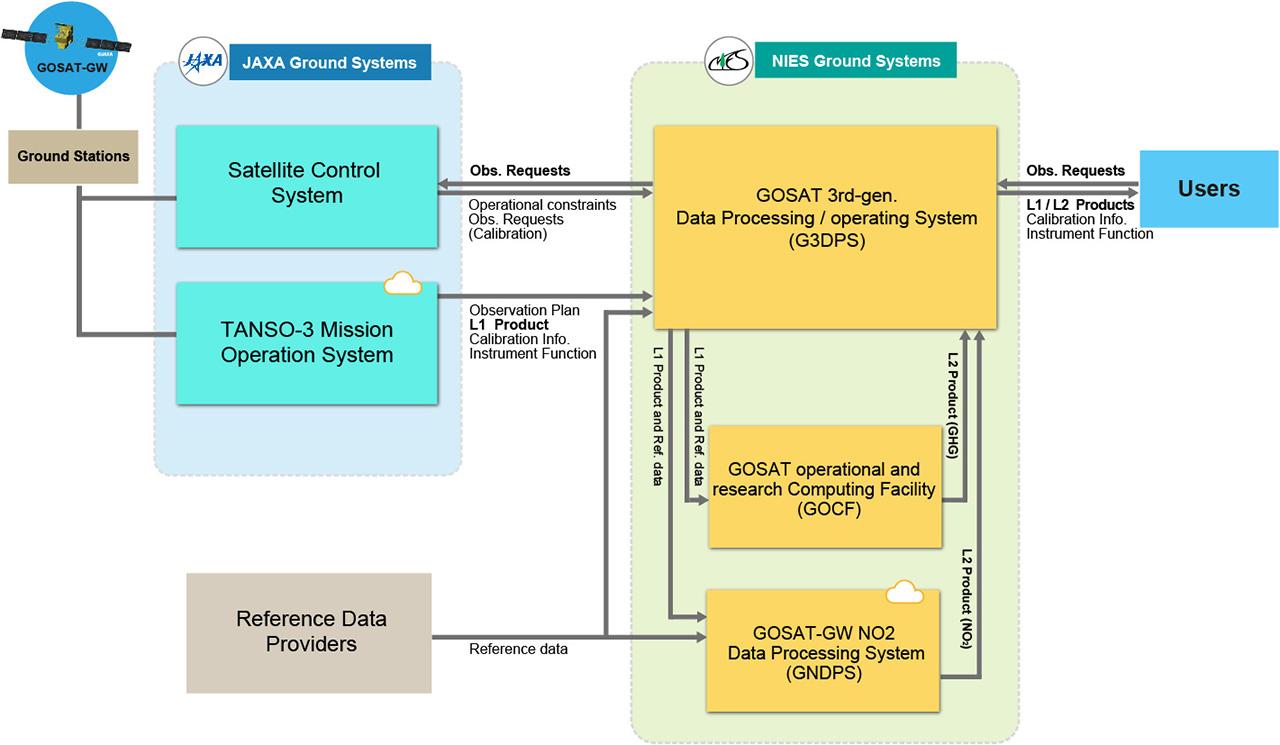
TANSO-3 observation data ground segment
TANSO-3 observation data will be transmitted by the GOSAT-GW satellite to JAXA via ground stations in the Arctic region. JAXA will generate TANSO-3 Level 1 products which contain spectral radiance data at the top of the atmosphere, and transfer them to NIES. The gas amount and concentration products generated at NIES will be categorised as "Level 2 products". NIES plans to generate monthly-basis Level 2 products for Wide Mode and Focus Mode, which contain XCO2, XCH4, SIF, NO2, etc. "Quick Delivery" Level 2 products, which are less accurate but distributed faster than monthly-basis products, are also planned to be generated for a limited number of Focus Mode observations. 1)
TANSO-3 standard products, both Level 1 and Level 2, will be available for free from NIES. Details will be described in TANSO-3 Data Policy.
NIES ground systems for the GOSAT-GW TANSO-3 mission mainly consist of three systems:
- GOSAT 3rd-generation Data Processing/operating System (G3DPS) receives, manages, distributes, and archives TANSO-3 products. It also handles observation requests.
- GOSAT operational and research Computing Facility (GOCF) is a supercomputer system that supports data processing by G3DPS. It processes TANSO-3 Level 2 products of CO2 and CH4.
- GOSAT-GW NO2 Data Processing System (GNDPS) manages data processing of TANSO-3 Level 2 products of NO2.
References
1) NIES, 2022. “GW Project: Satellite Observation Center”. URL: https://gosat-gw.nies.go.jp/en/index.html.
2) Kachi, M., Usuki, S. and Taga, M., 2022. “Status of GCOM-W and GOSAT-GW/AMSR3”, JAXA. URL: https://earth.jaxa.jp/files/research/PI_meeting/FY2021/3_FY2021PIWS_Plenary_AMSRs_rev4.pdf
3) Kachi, M., Murukami, H. and Kubota, T., 2019. “Current status and future plan of JAXA Earth observation missions for Climate Studies and Operational Applications”. JAXA. URL: http://www.bom.gov.au/research/aomsuc-10/presentations/S1-P11-KACHI.pdf
4) Kachi, M. and Fujii, H., 2020. “The Advanced Microwave Scanning Radiometer 3 (AMSR3) updates”. JAXA. URL: http://gsics.atmos.umd.edu/pub/Development/20210121/AMSR3_GSICS_MWSG_20210121_M.Kachi.pdf
5) JAXA / EORC, 2021. “AMSR-related Satellite Catalog #8211; AMSR web at Jaxa Earth Observation Research Center (EORC)”, AMSRs web. URL: https://www.eorc.jaxa.jp/AMSR/satellite/gosat-gw_en.html#satellite-spec
6) Mitsubishi Electric, 2020. “Mitsubishi Electric Begins Developing the GOSAT-GW Satellite for Greenhouse Gases and Water Cycle Observation”. URL: https://www.mitsubishielectric.com/news/2020/0330.html