Ikonos-2
EO
Atmosphere
Cloud type, amount and cloud top temperature
Cloud type
Launched by Space Imaging in 1999, Ikonos-2 was the world’s first commercial high-resolution imaging satellite. Ikonos-2 was built in parallel with and as an identical twin to Ikonos-1, however failure to launch Ikonos-1 led to the renaming of Ikonos-2 to Ikonos following its launch. Ikonos-2 was decommissioned in March 2015, ending a 15-year mission life.
Quick facts
Overview
| Mission type | EO |
| Agency | GeoEye |
| Mission status | Mission complete |
| Launch date | 24 Sep 1999 |
| End of life date | 31 Mar 2015 |
| Measurement domain | Atmosphere, Land |
| Measurement category | Cloud type, amount and cloud top temperature, Multi-purpose imagery (land), Vegetation, Albedo and reflectance |
| Measurement detailed | Cloud type, Land surface imagery, Vegetation type, Earth surface albedo |
| Instruments | MS, PAN |
| Instrument type | Imaging multi-spectral radiometers (vis/IR), High resolution optical imagers |
| CEOS EO Handbook | See Ikonos-2 summary |
Related Resources

Summary
Mission Capabilities
Ikonos-2 carried the Optical Sensor Assembly (OSA) instrument, which had four multispectral bands and one panchromatic band offering simultaneous imaging in both panchromatic and multispectral modes. The instrument also had pushbroom detector technology that generated 6500 lines/s of panchromatic image data.
Its applications include many aspects of environmental and resource monitoring.
Performance Specifications
OSA had a primary mirror aperture of 70 cm and a folded optical focal length of 10 m. Using five mirrors, it captured imagery across a swath of 11-13 km. The multispectral bands corresponded to those of Thematic Mapper (TM) on Landsat in the visible range of the spectrum.
The satellite was in a sun-synchronous near-polar circular orbit, at an altitude of 681-709 km and inclination of 98.1o. The revisit cycle was 1-3 days for observations at 40o latitude or higher. The LTDN (Local Time on Descending Node) was at 1030 hours, and the period was 98 minutes.
Space and Hardware Components
Ikonos-2 used the LM900 satellite bus system (also referred to as Block-1), which was based on the Commercial Remote Sensing System (CRSS) imaging bus designed by Eastman Kodak Co. Ikonos-2 long outlasted its design life of 7 years, collecting 0.82 m resolution black-and-white imagery and multispectral data with a resolution of 3.28 m.
The spacecraft operations of Ikonos-2 were unique among the commercial imaging satellites as it allowed each international affiliate to operate its own ground stations. These ground stations were assigned blocks of time on the satellite during which they could directly task Ikonos-2, and immediately receive the downlinked imagery for which they were tasked. It allowed each affiliate to make the best use of local weather data, in addition to receiving data almost instantly. This capacity, however, was only available when the ground station was in communication with Ikonos-2.
Ikonos-2
Overview Spacecraft Launch Mission Status Sensor Complement References
Ikonos-2 is a commercial high-resolution imaging satellite of DigitalGlobe, Longmont, CO, USA, providing high-resolution imagery on a commercial basis. With Ikonos-2, a new era of 1 m spatial resolution imagery began for spaceborne instruments in the field of civil Earth observation. The Ikonos project was managed by LMMS (Lockheed Martin Missiles & Space) with HQ in Sunnyvale, CA; the satellite was designed and built by Lockheed Martin Commercial Space Systems.
Overview
• Initially, CRSS (Commercial Remote Sensing System) was a remote sensing imaging satellite project of Lockheed Martin that started in 1991. In 1994 a new company was formed for this venture, namely Space Imaging Inc. with the following partners: LMMS: (space segment, satellite operations, and tasking of ground segment), Raytheon/E-Systems (Garland TX: communications, image processing and customer service center). Eastman Kodak Co. of Rochester, NY designed and built the digital camera/sensor. The overall objective was to offer commercial high-resolution (1 m GSD panchromatic and 4 m GSD multispectral) imagery with excellent location knowledge in near real-time and offline.
• In Aug. 1995, Space Imaging was awarded a license by the FCC (Federal Communications Commission) to construct, launch and operate a commercial remote sensing satellite system comprised of two satellites. In 1997 the CRSS satellite was renamed by Space Imaging to "Ikonos-1," supposedly a variant of the Greek word `eikon' (icon), meaning "image." Note: Space Imaging acquired EOSAT (a joint venture of Lockheed Martin and Hughes Aircraft) in 1995. The new company was subsequently renamed into: Space Imaging EOSAT. Eventually, it became simply: Space Imaging Inc. 1)
• Launch: A launch of Ikonos-1 took place on April 27, 1999 from VAFB aboard an Athena 2 launcher. Unfortunately, the rocket's nose cone failed to separate as planned at 4 minutes, 27 seconds into the flight - resulting in a complete loss of the satellite. With the protective shroud still attached, the rocket's upper stage and satellite did not have enough speed to reach a stable orbit around Earth. The vehicle then reentered the atmosphere over the South Pacific Ocean.
• Launch of Ikonos-2: The spacecraft was launched successfully on Sept. 24, 1999 from VAFB, CA aboard an Athena 2 launcher of Lockheed Martin. Space Imaging began to sell Ikonos-2 imagery on January 1 2000.
• In 2000, Space Imaging was awarded one of the most coveted prizes for technological achievement in the space industry - "The Industry Innovation Award in the Technology Category" - from the Society of Space Professionals International, due to the excellent performance of Ikonos-2.
• As of Sept. 2005, Lockheed Martin and Raytheon, the parent companies of Space Imaging, have agreed to sell Space Imaging to OrbImage Inc. of Dulles, VA.
• On January 12, 2006, the commercial imaging company GeoEye was established (merger completed), made up of former Orbimage of Dulles VA, and of Space Imaging of Thornton, CO (Orbimage acquired Space Imaging and gave the merged company the new name of GeoEye). The new company has HQs in Dulles, VA. - Hence, the Ikonos-2 spacecraft is now owned and operated by GeoEye (the company operates in 2008 also the imaging missions OrbView-2 and OrbView-3, the GeoEye-1spacecraft was launched on Sept. 6, 2008). 2)
• In July 2012, DigitalGlobe, Inc. and GeoEye, Inc. (Dulles, VA) have announced that the boards of directors of both companies have unanimously approved a definitive merger agreement under which the companies will combine in a stock and cash transaction. The combined company will be named DigitalGlobe. The combination of DigitalGlobe and GeoEye creates a global leader in earth imagery and geospatial analysis. 3)
• The merger was realized on January 31, 2013. The current (2013) constellation of DigitalGlobe includes the following missions: Ikonos-2 (launch 1999), QuickBird (2001), WorldView-1 (2007), GeoEye-1 (2008), and WorldView-2 (2009). 4)
Spacecraft
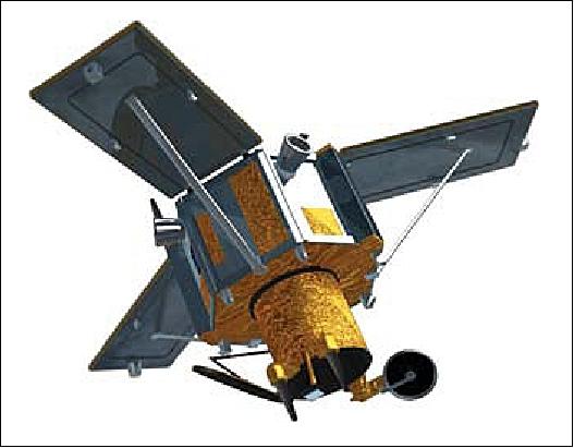
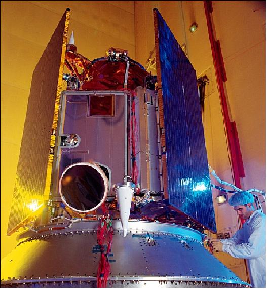
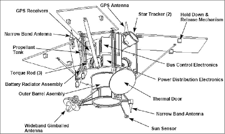
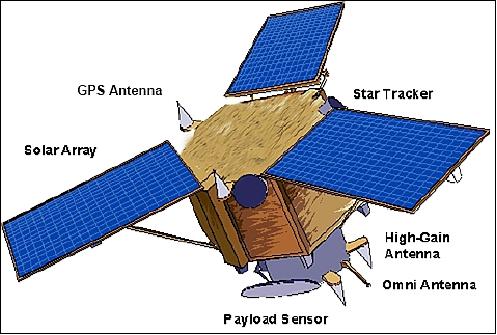
Ikonos-2 is a 3-axis stabilized spacecraft, using the LM900 satellite bus system (also referred to as Block-1). The LM900 spacecraft design was based on the CRSS imaging bus. The attitude is measured by two star trackers and a sun sensor and controlled by four reaction wheels (actuators); location knowledge is provided by a GPS receiver. The spacecraft provides precision pointing on an ultra-stable highly agile platform. The spacecraft features a body-pointing technique permitting a field of regard (FOR) of ±30º into any direction. This provides excellent observation capabilities. The design life is 7 years; S/C body size=1.83 m x 1.57 m (hexagonal configuration); S/C mass = 817 kg; power = 1.5 kW provided by 3 solar panels. 5)
Launch
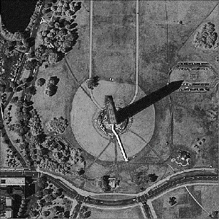
Ikonos-2, (identical to Ikonos-1 and built in parallel to Ikonos-1), was launched successfully on Sept. 24, 1999 from VAFB, CA aboard an Athena 2 launcher of Lockheed Martin. - On Oct. 12, 1999, Space Imaging released the world's first high-resolution commercial satellite image of the Earth - a 1 m resolution black-and-white image of Washington, D.C. (see Figure 18).
RF communications: The downlink of all imaging data is in X-band (8345.968-8346.032 MHz) at a rate of 320 Mbit/s to dedicated ground stations located around the world (on-board data recording capacity is 64 Gbit in solid-state memory). The TT&C function is provided in S-band (2025-2110 MHz, uplink of tasking and command data at 2 kbit/s, downlink of housekeeping data and metadata at 32 kbit/s). 6)
The spacecraft operations of Ikonos-2 is unique among the current commercial imaging satellites in that it allows each international affiliate to operate its own ground station(s). These ground stations are assigned blocks of time on the satellite during which they can directly task Ikonos, and immediately receive the downlinked imagery for which they tasked. In addition to virtually instant data receipt, this allows each affiliate to make the best use of local weather data. However, this capability is only available when the ground station is in contact with Ikonos-2.
Orbit: Sun-synchronous near-polar circular orbit, altitude = 681-709 km, inclination = 98.1º, period = 98 min, repeat cycle = 14 days (max), revisit cycle = 1-3 days (for observations at 40º latitude or higher). The local equator crossing time is at 10:30 AM on the descending node.
Mission Status
• May 28, 2015: Prior to the launch of Ikonos on September 24, 1999, only a small number of people around the world were able to see high-quality images of Earth taken by spacecraft, according to Walter Scott, DigitalGlobe's chief technology officer and founder. "A large percentage of the human race now has the ability to see the world from the comfort of their smartphone or their desktop essentially anywhere on the planet" thanks to satellite data, Scott told Mashable in an interview. 7)
- In all, Ikonos took 597,802 public images in its lifetime, covering more than 400 millionkm2 — about three times the size of Earth's land surface area, according to DigitalGlobe.
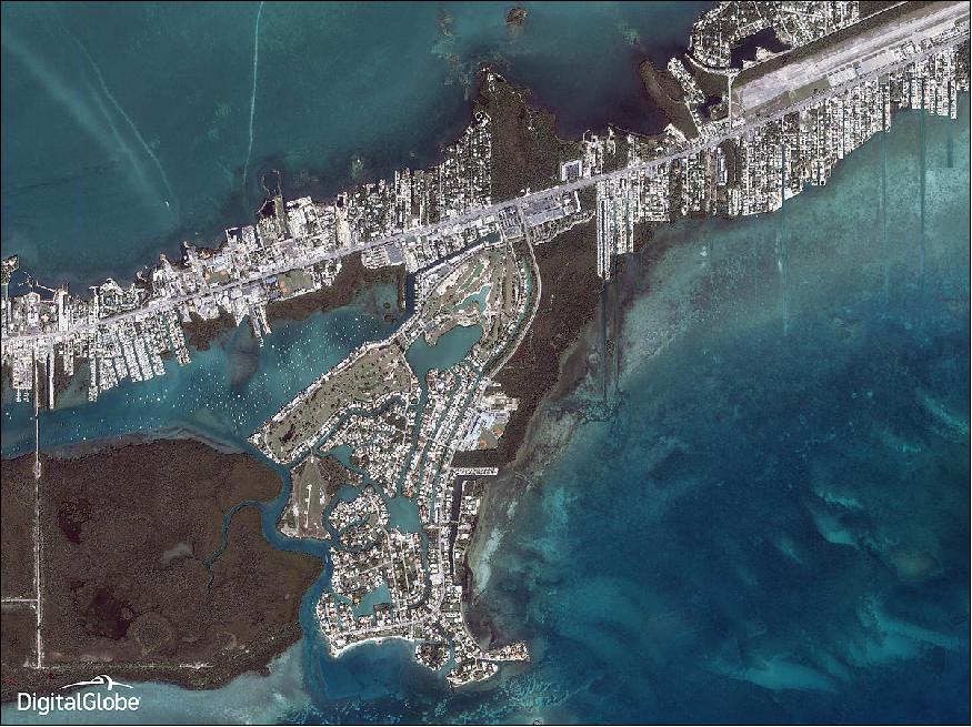
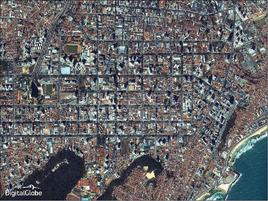
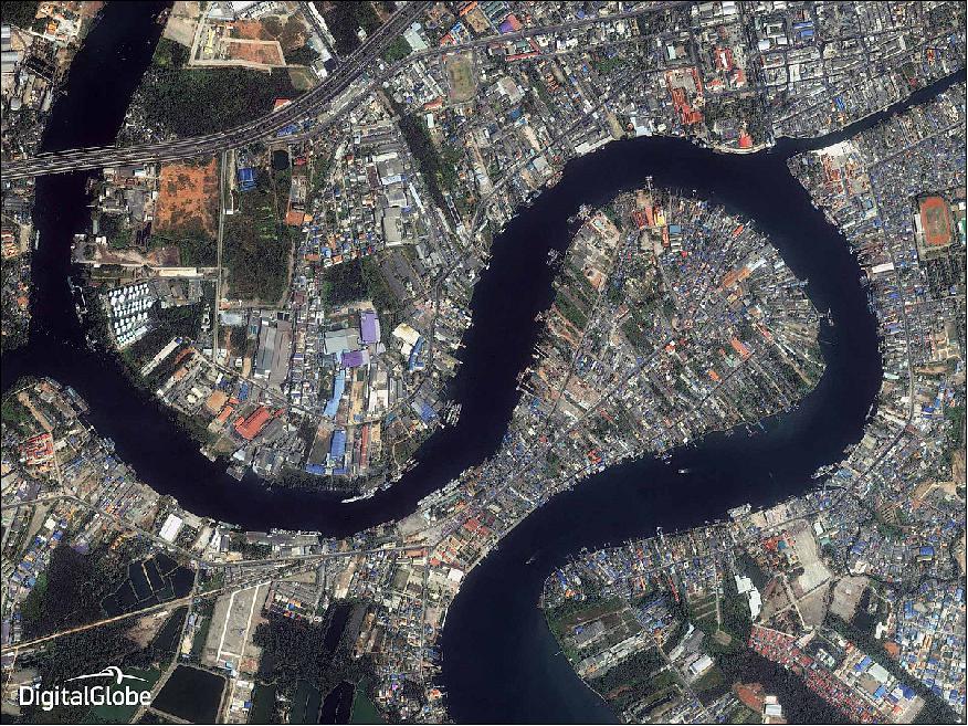
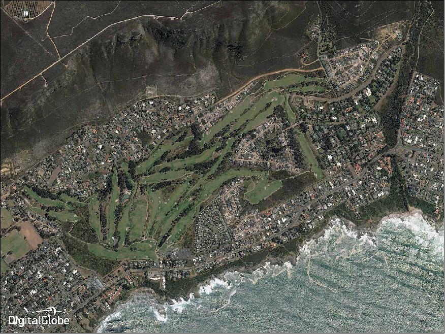
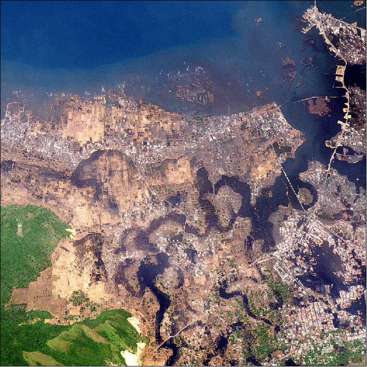
- The satellite took its last photos in December 2014, and they span the globe. The four images (Figure 5 through 8) show four different countries. A photo of Marathon, Florida puts the deep and light blues of the ocean on display next to the bright, white developments of the city. Another picture shows the roads and red-roofed houses of Natal, Brazil. A river snakes through Thailand in the third photo, and waves lap against the coast of South Africa in the fourth.
- March 31, 2015 marked a significant milestone for the commercial satellite industry, as DigitalGlobe officially retired Ikonos, the world's first high-resolution commercial imaging satellite.
• May 14, 2015: DigitalGlobe's IKONOS-2 commercial imaging satellite, built by Lockheed Martin, was retired (and decommissioned) on March 31, 2015 after a more than 15-year service life. The satellite was owned and operated by DigitalGlobe, Inc., and performed on-orbit for more than double its original design life. 8)
- IKONOS was the world's first sub-meter commercial earth imaging satellite, kick-starting what would become a multi-billion dollar industry for high resolution satellite imagery and geospatial products and services. Over its lifetime, IKONOS-2 collected more than 400 million km2 of Earth imagery. 9)
• The Ikonos-2 spacecraft and its payload are operating 'nominally' in 2015. A decommissioning of Ikonos-2 is planned for late 2015. 10) 11)
- Ikonos-2 satellite sensor status update: On January 22, 2015 DigitalGlobe announced that during recent maintenance activities, DigitalGlobe attempted to resolve an irregularity in the accuracy of imagery collected by the IKONOS satellite sensor. After extensive testing, DigitalGlobe has determined that the accuracy of IKONOS imagery does not meet DigitalGlobe's product quality specifications, and subsequently, the established A3C (Accuracy, Currency, Completeness, and Consistency) quality standards. — During this evaluation period, DigitalGlobe will not accept new IKONOS tasking orders. Customers will still be able to order IKONOS Archive imagery, as archive imagery has not been affected by the recent change in accuracy and continues to meet the core product specifications and quality standards. 12)
• On Sept. 24, 2014, the Ikonos-2 spacecraft, built by Lockheed Martin, was 15 years on orbit. Ikonos continues to perform more than seven years beyond its initial design life, collecting 0.82 m resolution black-and-white imagery and multispectral data with a resolution of 3.28 m. 13)
• Ikonos-2 of DigitalGlobe is operating nominally in 2014 in its 15th year on orbit. 14)
EUSI (European Space Imaging) of Munich, Germany (since 2002), is a DigitalGlobe Alliance partner. This gives EUSI more freedom than just a regular distributor, such as being able to set its own license terms and pricing. EUSI is currently (2014) tasking and receiving data from the WorldView-1 and-2 satellites and is discussing re-activating the tasking and receiving station for Ikonos-2. Both are based at DLR Oberpfaffenhofen. EUSI owns the data it receives via its stations. 15)
ESA receives also Ikonos-2 data via its ground stations in a 'Third Party Mission' license agreement with DigitalGlobe. These data are being used to test and demonstrate various aspects for the future services of the Copernicus satellite series.
In April 2010, EUSI started operating EDAF (European Direct Access Facility) for the acquisition of WorldView-1/2 data. In 2013, EDAF is providing imagery of the following satellites: Ikonos-2, Quickbird-2, WorldView-1/2, GeoEye-1, and EROS-B. EDAF is located at DLR, Oberpfaffenhofen and is jointly operated by EUSI and DLR. 16) 17)
• Ikonos-2 is operating nominally in 2013.
Merger of DigitalGlobe and GeoEye 18) 19) 20)
• On January 31, 2013, DigitalGlobe and GeoEye have completed their merger, creating a global leader in Earth imagery and geospatial analysis. Hence, Ikonos-2 is now being owned and operated under the label of DigitalGlobe. 18) 19)
- The merger was forced by the government's decision to reduce funding for commercial satellite imagery purchases in light of budget constraints and reduced demand for this type of satellite imagery. 20)
- Though referred to as commercial companies, both GeoEye and DigitalGlobe have been heavily dependent on the government as a market for their high resolution satellite imagery. A series of contracts over the past decade under the auspices of the National Geospatial-Intelligence Agency (NGA), part of the Intelligence Community, assured the companies of sufficient revenue to build new satellites and remain solvent as they sought to develop non-government markets.
- Last year, however, NGA informed GeoEye that it would not continue supporting the company under the most recent contract, EnhancedView, signed in 2010. The Senate Armed Services Committee attempted to come to GeoEye's rescue, but by the time the FY2013 National Defense Authorization Act reached the final stages of negotiation in late December, the die was cast.
- From a space policy perspective the government's decision to discontinue its arrangement with GeoEye is an opportunity to extract lessons learned about public-private partnerships in commercial space. The growing number of companies looking to the government to help fund their space systems and serve as a market for their wares also might be well served to recalibrate expectations. Policies are good, but they are often trumped by budgets.
• Ikonos-2 is operating nominally in 2012 (and completed 13 years on orbit on Sept. 24, 2012).
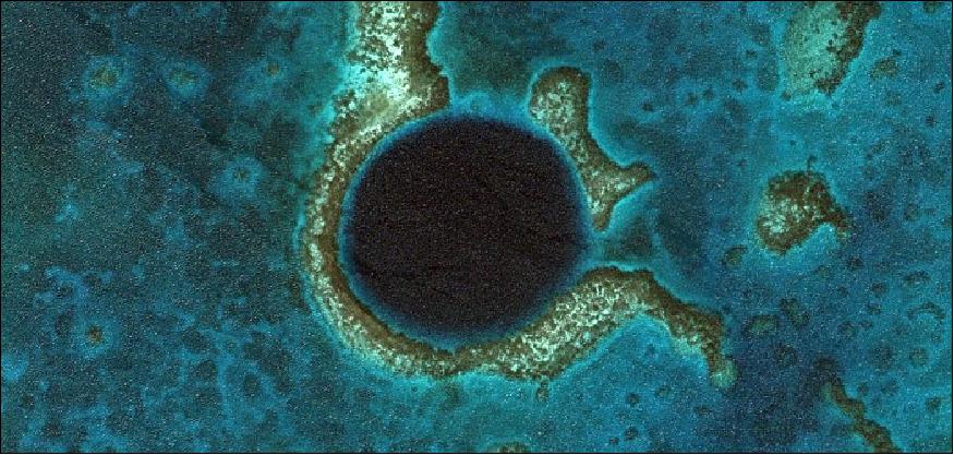
Legend to Figure 10: This IKONOS image (with a spatial resolution of 0.82 m) shows the Great Blue Hole, a near perfect circle off the coast of Belize mainland. It is a submarine sinkhole surrounded by the shallow waters of the Lighthouse Reef Atoll, a small atoll 80 km from the mainland. The hole is over 300 m across and 124 m deep. The Great Blue Hole, which became a World Heritage Site in 1997, is a part of the larger Belize Barrier Reef Reserve System, a World Heritage Site of the United Nations Educational, Scientific and Cultural Organization (UNESCO).

• Ikonos-2 is operating nominally in 2011 (the spacecraft is on-orbit in its 12th year). A mission end is estimated to be at the end of 2011.
- Geolocation accuracy of Ikonos-2: The geolocation accuracy is regularly tested by imaging Big Spring, TX. A painted target and multiple other checkpoints are measured from the image. The difference between the position measured in the image and predicted by the RPC camera model is plotted in Figure 12. The charts show absolute accuracy, as difference from zero, and relative accuracy, as coincidence of multiple target measurements from the same scene. Ikonos calibrations were recently updated to correct a southward drift in calibrations since the last update in 2007. 22)
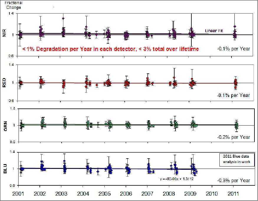
- Ikonos-2 radiometric stability: Standard calibration stars have been imaged each year (with the exception of 2010) and used to measure degradation in detector response. IKONOS continues to show excellent stability with < 1% degradation per year and < 3% degradation over its entire life to date, and no failed detectors.
- Ikonos-2 focus assessment: A yearly focus assessment is performed by imaging the same target multiple times while moving the focus mirror from an out-of-focus position through its ideal focus. The latest "through-focus" assessment in the fall of 2010, resulted in no need for a focus adjustment. Focus adjustments have not been needed since 2006, consistent with an asymptotic leveling-off of telescope growth (Ref. 22).
• On Sept. 24, 2009, the Ikonos-2 spacecraft marked 10 years in orbit. The world's first high-resolution satellite continues to provide imagery of the Earth to commercial and government customers around the world. 23)
• In October 2008, Telespazio (Finmeccanica/Thales) signed an agreement with GeoEye to sell imagery from the GeoEye-1 and the Ikonos-2 satellites in Europe and North Africa. Telespazio is the new European Commercial Regional Affiliate (CRA), with exclusive distribution rights for both GeoEye-1 and Ikonos satellites. The multiyear agreement applies for imagery acquired from January 1, 2009 onwards. 24)

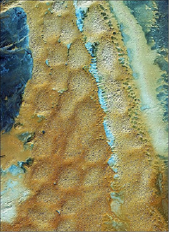
Legend to Figure 14: This image was featured by ESA on Jan. 20, 2012 in its series "Earth from Space: Golden curves." This image shows clays and sand soils which have a high surface salt content owing to the concentration of minerals from high summer evaporation. Iran is one of the world's most important mineral producers. Earth-observing satellites are useful for finding and monitoring natural resources like minerals. 25)
ESA supports Ikonos-2 as a Third Party Mission, which means that the Agency uses its multi-mission European ground infrastructure and expertise to acquire, process and distribute data from the satellite to its wide scientific user community.
• Ikonos-2 is operating nominally in 2008 - and there are no signs of data deterioration or component failure. Ikonos-2 continues to perform almost flawlessly in terms of quantity and quality of imagery that it collects. GeoEye estimates that Ikonos-2 may continue its operational life into the next decade (the analysis on the life expectancy was performed Lockheed Martin Corporation in the fall of 2007). 27)
• The company GeoEye distributes Ikonos-2 imagery under the trade name of CARTERRA (same name as was used by Space Imaging).
• August 2003: The IKONOS satellite simultaneously collects 1-m panchromatic and 4-m multispectral images, providing the commercial and scientific community with a dramatic improvement in spatial resolution over previously available satellite imagery. 28)
• The Ikonos-2 spacecraft became operational in December 1999.
• On Oct. 12, 1999, Space Imaging released the world's first high-resolution commercial satellite image of the Earth. The 1 m resolution black-and-white image of Washington, D.C., observed by Ikonos (Figure 18). 30) 31)
Sensor Complement
OSA (Optical Sensor Assembly)
OSA was designed and custom-built by Kodak Co. of Rochester, NY (Space Imaging owns the design of OSA). The instrument features a Cassegrain-type telescope with a 70 cm diameter primary mirror, a 10 m focal length (folded optics design). The OTA (Optical Telescope Assembly) captures imagery across a swath of 11-13 km, it uses five mirrors to reflect the imagery to the imaging sensor arrays at the back end of the telescope. Three of the mirrors are powered (curved), and are of TMA (Three Mirror Anastigmatic) design. Note: TMA refers to lenses that are able to form approximately point images of target (object) points. The other two mirrors are flat, and serve to `fold' or bounce the imagery across the width of the telescope.
Pushbroom detector technology (a large focal plane detector array, generation of 6500 lines/s of panchromatic image data) is employed. Simultaneous imaging in panchromatic and multispectral modes is provided. The pixel size on the detector array is 12 µm for the panchromatic (PAN), and 48 µm for the multispectral (MS) detectors.
The MS bands correspond to those of TM on Landsat in the visible range of the spectrum. The instrument light level is governed by a 70 cm aperture and a choice of 10, 13, 18, 24, or 32 TDI (Time Delay Integration) stages for panchromatic (gray-scale) imaging. The detector array offers a cumulative exposure concept for panchromatic imaging. 32)
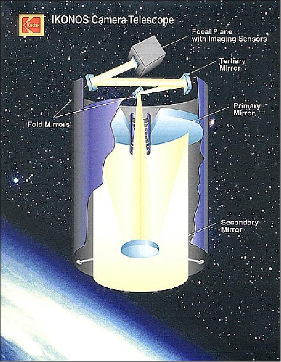
On-board electronics provide low-loss data compression of the original 11-bit data using ADPCM (Adaptive Differential Pulse Code Modulation). - The OSA instrument design features lightweight materials and advanced manufacturing techniques. The mass of the primary mirror was reduced by cutting a honeycomb pattern into its core using abrasive waterjet technology, and fusing thin mirror plates to each face.
Optical telescope assembly | Assembly size: 1.524 m x 0.787 m (1 m3 volume) |
Imaging detectors & electronics | Focal plane unit, unit size: 25 cm x 23 cm x 23 cm |
Digital processing unit | Unit size: 46 cm x 19 cm x 31 cm |
Power supply unit | Unit size: 18 cm x 20 cm x 41 cm |
Total instrument mass, power | 171 kg, 350 W |
A body-pointing technique with antenna gimbals and reaction wheels is employed for instrument pointing (the entire S/C is pointed into the desired direction), permitting a field of regard of ±30º into any direction. The angular slew rate is sufficient to perform both wide-area monoscopic and same-pass stereo collections. The location knowledge accuracy of the imagery is 2 m horizontal (relative) i.e. with ground control points, and 12 m (absolute), i.e. without the use of ground control points. Smooth scanning is provided with accurate gyros, low disturbance torques (smooth antenna gimbals and reaction wheels), and a rigid high-frequency structure of the satellite.
The S/C may also be rotated about its imaging axis for proper (broadside) detector array orientation. This technique permits, for instance, the full-swath imaging of a particular feature of interest on the Earth's surface, such as a coastline, which traverses under some angle through the in-track direction.
Parameter | Value | Parameter | Value |
Spectral range PAN | 0.45 - 0.90 µm | Off-nadir pointing angle | ±30º in any direction |
Spectral range MS (µm) | 0.45-0.53, (blue) | Stereo capability | along-track |
Spatial resolution | 1 m PAN (0.82 m at nadir), 4 m MS (3.2 m at nadir) | Swath width (single image) | 11.3 km x 11.3 km |
Pixel quantization | 11 bit | Field of regard (FOR) | ±350 km at 1 m GSD |
The data acquisitions of PAN and MS imagery data are simultaneous and fully co-registered; mono or stereo. 35) 36)
Instrument calibration: The agile pointing capability of Ikonos is being utilized for instrument calibration. Solar, lunar and stellar scenes serve as radiometric instrument calibration sources. The ecliptic portion of the orbit is being used for stellar calibration. Absolute calibration of the Ikonos sensors is performed by comparing the total digital numbers found in the stellar image, to the absolute in-band spectral radiance of several radiometrically characterized stars. The radiometric calibration provides relative and absolute corrections for detector channel responsivity differences. 37) 38)
Since launch, the Ikonos-2 satellite has undergone a series of geometric calibrations. The Ikonos geometric sensor model includes the interior orientation parameters, i.e. the Field Angle Map (FAM), and the elements of the exterior orientation parameter set, namely the interlock angles. The initial values of the interlock angles and the FAM parameters were determined by pre-launch measurements. They were subsequently refined by a series of on-orbit geometric calibrations.
Ground image data processing provides geocoding along with image compensation algorithms [misregistration, image motion, radiometric correction, MTF (modulation transfer function) compensation, etc.]. Space Imaging Inc. introduced a global archive (of digital imagery and services) under the trade name CARTERRA, which in turn is made up of regional archives, operated by regional partners. A great variety of image products and services are provided. Standard products are:
• Radiometrically corrected images
• Geometrically corrected images
• Orthorectified images and mosaics
• Digital terrain model (DTM) data
• Multispectral images
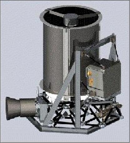
Kodak Model 1000 Camera System
As of July 1999, Kodak/C&GS (Commercial & Government Systems) is offering a "Model 1000™ camera system" of OSA camera heritage as an off-the-shelf product - at a 30% discount, deliverable within 24 months of order placement. This Model 1000 system design is owned by Kodak, containing some design changes with respect to OSA (reduced telescope aperture and instrument mass to fit onto minisatellites). 39) 40) 41)
The Model 1000 camera system consists of the following elements: OTU (Optical Telescope Unit), FPU (Focal Plane Unit), DPU (Digital Processing Unit), PSU (Power Supply Unit), and CU (Cabling Unit). The total mass of the system is <100 kg.
• The OTU is an all-reflective three mirror anastigmatic design with two flat fold mirrors to decrease package volume (Korsch TMA telescope design). The optical components are made from high quality, low thermal expansion glass substrates. The metering and mounting structures are made from low thermal expansion materials to match the expansion properties of the glass components. OTU has a mass of 45 kg, the power consumption is 15 W.
• The FPU includes the PAN and MS detectors and A/D converters. Timing and command signals are received from the DPU, power is received from the PSU. The mass of FPU is 16 kg, power = 85 W.
• The DPU generates the timing for the sensor electronics via a master clock. DPU accepts S/C commands over a standard 1553 bus and routes the information to the FPU and PSU. The DPU compresses the 11 bit digitized image data to about 2.5 bits/pixel using the Kodak proprietary algorithms of ADPCM (Advanced Differential Pulse Code Modulation). The DPU can format data for interface with an on-board storage unit and data downlink. DPU mass = 14 kg, power = 130 W.
• The PSU filters, regulates and generates the unregulated S/C power to the DPU and PSU. Mass = 8 kg, power 75 W. There is full redundancy.
• The CU provides the cabling between the various electronic boxes. Mass = 5kg, power = 10W.
Spectral range PAN (panchromatic) | 0.45 - 0.90 µm |
Spectral range MS (multispectral) | 0.45-0.52 µm, 0.52-0.60 µm, 0.63-0.69 µm, 0.69-0.90 µm |
Spatial resolution (GSD) | 0.82 m PAN, 3.2 m MS, orbital altitude of 600 km |
Swath width | 12.2 km |
Design life | 5 years |
Optical system parameters | |
Clear aperture of primary mirror | 44.8 cm diameter |
Effective focal length; Focal ratio (f/number) | 8.0 m / f/17.9 |
FOV along-track, FOV cross-track | 0.75º, 1.19º |
Panchromatic focal plane detector array |
|
Multispectral focal plane detector array |
|
Imaging performance parameters | |
MTF @ Nyquist PAN (41.6 lp/mm) | 0.09 (camera geometric mean of in- and cross-track) |
SNR (80% scene reflectance, 20% background reflectance, 2.66 mW/cm2 sr µm, 30º sun angle), PAN (24 TDI stages) | >45 |
Data quantization | 11 bits |
Data compression technique | ADPCM, 2.5 bits/pixel |
References
1) Information provided by S. Kilston, formerly of Lockheed Martin, Palo Alto, CA
2) "ORBIMAGE Completes Acquisition of Space Imaging; Changes Brand Name to GeoEye ," GeoEye, January 12, 2006
3) "Digitalglobe And Geoeye Combine To Create A Global Leader," Space Daily, July 26, 2012, URL: http://www.spacedaily.com/reports/Digitalglobe_And_Geoeye_Combine_To_Create_A
_Global_Leader_999.html
4) Brett Thomasie, "Digitalglobe Incorporated Corporate and Satellite Program Update," 12th Annual JACIE (Joint Agency Commercial Imagery Evaluation) Workshop , St. Louis, MO, USA, April 16-18, 2013, URL: https://calval.cr.usgs.gov/wordpress/wp-content/uploads/DigitalGlobeOverview_-JACIE2013.pdf
5) "Ikonos Data Sheet," DigitalGlobe, URL: https://dg-cms-uploads-production.s3.amazonaws.com/uploads/document/file/96/DG_IKONOS_DS.pdf
6) W. Martin, "Satellite image collection optimization," Optical Engineering, Vol. 41, No 9, Sept. 2001, pp.2083-2087
7) Miriam Kramer, "The life and death of Ikonos, a pioneering commercial satellite," Mashable, May 28, 2015, URL: http://mashable.com/2015/05/28/ikonos-satellite-digitalglobe/
8) "DigitalGlobe's IKONOS Satellite Retired After 15 Years of On-Orbit Operation," Lockheed Martin, May 14, 2015, URL: http://www.lockheedmartin.com/us/news/press-releases/2015/may/SSC-021415-ikonos-retirement.html
9) "Ikonos decommissioned," European Space Imaging, March 31, 2015, URL: http://www.euspaceimaging.com/category-news/item/ikonos-2
10) "Ikonos-2," CEOS Database, 2015, URL: http://database.eohandbook.com/database/missionsummary.aspx?missionID=666
11) "Ikonos," Geoimage, 2015, URL: http://www.geoimage.com.au/satellite/ikonos
12) "Ikonos Satellite Sensor," Satellite Imaging Corporation, 2015, URL: http://www.satimagingcorp.com/satellite-sensors/ikonos/
13) "Ikonos Imaging Satellite Achieves 15 Years of On-Orbit Operation," Lockheed Martin, Sept. 24, 2014, URL: http://www.lockheedmartin.com/us/news/press-releases/2014/september/0924-space-IKONOS.html
14) https://earth.esa.int/web/guest/missions/3rd-party-missions/current-missions/ikonos-2
15) Information provided by Adrian Zevenbergen, Managing Director of EUSI (European Space Imaging)
16) "European Space Imaging's optical satellite services help keep the seas safe and clean," July 11, 2013, URL: http://www.directionsmag.com/pressreleases/european-space-imagings-optical-satellite-services-help-keep-the-seas-safe-/339225
17) Ansgar Kornhoff, "WorldView Alliance -European Access to WorldView-1/2 and QuickBird," Ground Segment Coordination Body (GSCB) Workshop, 6-7 June 2012, ESA/ESRIN, Frascati, Italy, URL: http://earth.esa.int/gscb/papers/2012/31-European_access_worldview_quickbird.pdf
18) "DigitalGlobe and GeoEye Complete Combination," DigitalGlobe, Press Release, Jan. 31, 2013, URL: [web source no longer available]
19) "DigitalGlobe and GeoEye Complete Combination," Space Daily, Feb. 6, 2013, URL: http://www.spacedaily.com/reports/DigitalGlobe_and_GeoEye_Complete_Combination_999.html
20) Marcia S. Smith, "DigitalGlobe and GeoEye Complete Merger," Space Policy Online.com, Jan. 31, 2013, URL: http://www.spacepolicyonline.com/news/digitalglobe-and-geoeye-complete-merger
21) "Great Blue Hole, World Heritage Site, Off the Coast of Belize," GeoEye, Dec. 28, 2012, URL: http://ambergriscaye.com/photogallery/121228.html
22) Martin H. Taylor, Gene Dial, "GeoEye's Imagery Collection and Production Services Current Performance and Future Systems," 10th Annual JACIE ( Joint Agency Commercial Imagery Evaluation) Workshop, March 29-31, 2011, Boulder CO, USA, URL: http://calval.cr.usgs.gov/JACIE_files/JACIE11/Posters/11.140_Taylor_JACIE2011_Poster.pdf
23) Klaus Schmidt, "IKONOS Satellite Marks 10 Years In Operations," URL: http://spacefellowship.com/news/art13608/ikonos-satellite-marks-10-years-in-operations.html
24) http://www.telespazio.com/docs/PressRel_GeoEye_en.pdf
25) "Earth from Space: Golden curves," ESA, January 20, 2012, URL: http://www.esa.int/esaEO/SEMLFANXDXG_index_0.html
26) "Earth from Space: Algerian sands," ESA 'Image of the week', March 9, 2012, URL: http://www.esa.int/esaEO/SEMZA68YBZG_index_0.html
27) Gene Dial, "GeoEye: Remote Sensing & Production Services," March 26, 2008, URL: http://calval.cr.usgs.gov/JACIE_files/JACIE08/2008_JACIE_DVD/Wednesday_PM/Dial_GeoEye.pdf
28) Gene Dial, Howard Bowen, Frank Gerlach, Jacek Grodecki, Rick Oleszczuk, "IKONOS satellite, imagery, and products," Remote Sensing of Environment, Vol. 88, 2003, pp. 23-26, URL: https://www.researchgate.net/publication/222571448_IKONOS_satellite_imagery_and_products
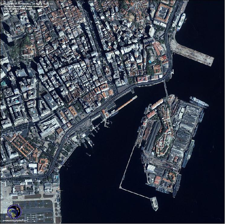
29) http://www.satimagingcorp.com/gallery/ikonos-rio-de-janeiro-port-brasil.html
30) "First Image from the IKONOS Satellite Shows Washington, D.C.," Oct. 12, 1999
31) http://www.geog.ucsb.edu/~jeff/115a/history/ikonos.html
32) "IKONOS Instrument/Product Description," GeoEye, 2009, URL: http://gmesdata.esa.int/geonetwork_gsc/srv/en/resources.get?id=376&fname=IKONOS_Product_guide_v2.pdf&access=private
33) http://uregina.ca/piwowarj/Satellites/IKONOS.html#Camera
34) http://cobweb.ecn.purdue.edu/~bethel/pictureperfect.pdf
35) Adrian Zevenbergen, "Ikonos and GeoEye-1," Ground Segment Coordination Body workshop, Frascati, Italy, June 19-20, 2007, URL: http://earth.esa.int/gscb/papers/20_Zevenbergen.pdf
36) "Ikonos Imagery Products," URL: http://www.glcf.umd.edu/library/guide/IKONOS_Product_Guide_jan06.pdf
37) Special Ikonos issue: Remote Sensing of Environment (Elsevier Science), Vol. 88, No 1, Nov. 30, 2003, ISSN 0034-4257,
38) H. S. Bowen, "Absolute Radiometric Calibration of the Ikonos Sensor Using Radiometrically Characterized Stellar Sources," Pecora 15/Land Satellite Information IV Conference, ISPRS Commission I Mid-term Symposium/FIEOS (Future Intelligent Earth Observing Satellites), Nov. 10-14, 2002, Denver, CO
39) Information provided by Michael J. Richardson of Eastman Kodak Company, Rochester, NY
40) "Kodak Introduces 1-Meter-Resolution Remote Sensing Camera In An Off-The-Shelf, Fixed Price Configuration," Kodak press release of July 19, 1999
41) T. Delaney, "Satellite Imagery in Land Development Applications," EOM, Oct. 1999, pp. 47-48
The information compiled and edited in this article was provided by Herbert J. Kramer from his documentation of: "Observation of the Earth and Its Environment: Survey of Missions and Sensors" (Springer Verlag) as well as many other sources after the publication of the 4th edition in 2002. - Comments and corrections to this article are always welcome for further updates (eoportal@symbios.space).
Overview Spacecraft Launch Mission Status Sensor Complement References Back to top